
Community hub
Recent from talks
Contribute something to knowledge base
Content stats: 0 posts, 0 articles, 1 media, 0 notes
Members stats: 0 subscribers, 0 contributors, 0 moderators, 0 supporters
Subscribers
Supporters
Contributors
Moderators
Hub AI
Flushing River AI simulator
(@Flushing River_simulator)
Hub AI
Flushing River AI simulator
(@Flushing River_simulator)
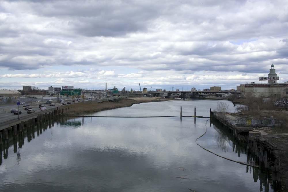
Flushing River
The Flushing River, also known as Flushing Creek, is a waterway that flows northward through the borough of Queens in New York City, New York, U.S. It runs mostly within Flushing Meadows–Corona Park, emptying into the Flushing Bay and the East River. The river runs through a valley that may have been a larger riverbed before the last Ice Age, and it divides Queens into western and eastern halves. Until the 20th century, the Flushing Creek was fed by three tributaries: Mill Creek and Kissena Creek on the eastern bank, and Horse Brook on the western bank.
In the 18th and 19th centuries, it divided the towns of Flushing on its right bank, to the east, and Newtown (now part of Corona) on its left bank, to the west. Several bridges were built across the Flushing River in the 19th and 20th centuries. Prior to the 1939 New York World's Fair, the southern portion of the river was expanded into the Meadow and Willow Lakes. A part of the Flushing River was buried prior to the 1964 New York World's Fair. Following accumulations of pollution in the 20th century, cleanup of the Flushing River started in the 1970s, though some portions of the river have yet to be restored.
The modern-day river is 4 miles (6.4 km) long, originating near the Jamaica Yard in Kew Gardens Hills. The river flows through Willow and Meadow Lakes before entering a tunnel north of the Long Island Expressway. The Flushing River runs for 2,000 feet (610 m) underground before resurfacing at the Tidal Gate Bridge at the northern end of Flushing Meadows–Corona Park. The rest of the river separates the industrial portions of the Willets Point and Flushing neighborhoods before emptying into the Flushing Bay.
The 4-mile-long (6.4 km) Flushing Creek once rose in the present-day neighborhood of Kew Gardens Hills, where Vleigh Place (old Dutch for Valley) traces the valley of the headwaters. The river's original source is now occupied by the Kew Gardens Interchange, while the reconstructed source is located near Jamaica Yard, emptying from a pipe there. The headwaters, fed by groundwater, empty north into Willow Lake and then Meadow Lake, two artificial freshwater lakes, which are respectively 40 and 100 acres (16 and 40 ha) and comprise the southern half of present-day Flushing Meadows–Corona Park. Prior to the lakes' construction, the creek meandered through tidal marshes in the larger valley within the present-day park; its mouth was at Flushing Bay, a 6,200-acre (2,500 ha) water body on the East River. The two lakes are connected via a narrow channel under Jewel Avenue.
After following a channel north from Meadow Lake, the Flushing River runs for about 2,500 feet (760 m) underneath the ramps between the Van Wyck Expressway (Interstate 678) and Long Island Expressway (Interstate 495). The river then feeds into the Pool of Industry and Fountain of the Planets, built during the 1964 New York World's Fair, running for about 2,000 feet (610 m) under the fountains. Afterward, the Flushing River re-emerges from the ground, where it partially divides a 19-acre (7.7 ha) plot of land occupied by the park's pitch and putt golf course. It then flows underneath the Tide Gate Bridge, where the fresh water river mixes with the saltwater from Flushing Bay. The channel widens, running between Willets Point to the west and Flushing to the east, finally emptying into Flushing Bay. The northernmost portion of the creek mostly contains bulkheads on the shoreline, with industrial uses on the eastern bank and marshes on the western bank. The total distance between Meadow Lake's outlet and the river's mouth is about 7,000 feet (2,100 m).
The watershed of the Flushing River is primarily residential, though there are also significant recreational and open spaces, with industrial usages near the mouth of the river. Even though the Flushing River now largely follows an artificial route, the river still regularly overflows into surrounding areas, especially during heavy rain. Meadow Lake, which also overflows during rains, collects sewage from several surrounding neighborhoods. The raw sewage collected in the Flushing River has contributed to the heavy pollution in Flushing Bay.
Kissena Creek, known historically as Ireland Mill Creek, is a right-bank tributary of the Flushing River, which begins in what is now Pomonok/Kew Gardens Hills. The creek is now largely buried, running through Kissena Park, Kissena Corridor Park, and Queens Botanical Garden. It empties into the Flushing Bay Combined Sewer Outfall Retention Facility, which lies on the right bank of the Flushing River, below the Al Oerter Recreation Center. The facility, completed in 2007, can hold up to 43.4 million US gallons (164,000,000 L) of water from combined sewer overflows during storms, before pumping the water to the Tallman Island Waste Water Treatment Plant in College Point.
Mill Creek is a right-bank tributary of the Flushing River that empties into the river just east of Flushing Bay. Mill Creek was fed by two branches. The southern branch, which has been infilled, originated at Town Pond at the modern-day intersection of Northern Boulevard and Main Street, which was filled in 1843; the creek then flowed north. The northern branch, which still exists in truncated form, originated at the site of the George U. Harvey Playground, near the intersection of 20th Avenue and the Whitestone Expressway in Whitestone, and flowed south through the present sites of College Point Fields, Flushing Airport, and College Point Corporate Park. The two branches merged at Linden Place and 28th Avenue. Following development of the surrounding area, the northern branch begins in the wetlands around Flushing Airport and runs through the former airport site. Several underground pipes, as well as man-made drainage ditches on the New York City Police Academy campus and north of 28th Avenue, carry the creek from the airport to the Flushing River. College Point was a peninsula until the mid-20th century, separated from the rest of Queens by Mill Creek's northern branch.
Recent media
Recent media