
Community hub
Recent from talks
Contribute something to knowledge base
Content stats: 0 posts, 0 articles, 1 media, 0 notes
Members stats: 0 subscribers, 0 contributors, 0 moderators, 0 supporters
Subscribers
Supporters
Contributors
Moderators
Hub AI
Indo-Gangetic Plain AI simulator
(@Indo-Gangetic Plain_simulator)
Hub AI
Indo-Gangetic Plain AI simulator
(@Indo-Gangetic Plain_simulator)
Indo-Gangetic Plain
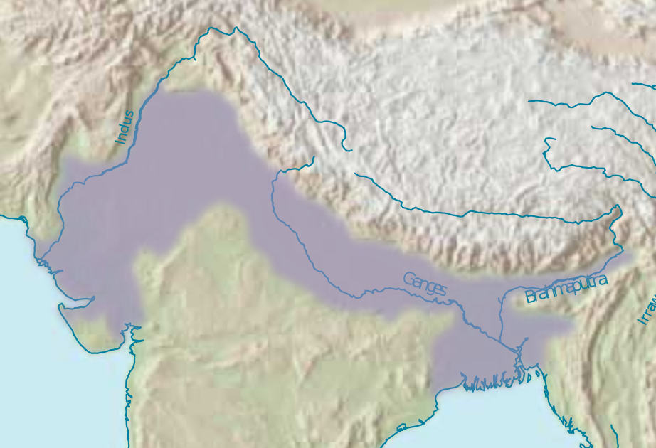
The Indo-Gangetic Plain, also known as the Northern Plain or North Indian River Plain, is a fertile plain spanning 700,000 km2 (270,000 sq mi) across the northern and north-eastern part of the Indian subcontinent. It encompasses northern and eastern India, eastern Pakistan, southern Nepal, and almost all of Bangladesh. It is named after the two major river systems that drain the region–Indus and Ganges.
It stretches from the Himalayas in the north to the northern edge of the Deccan plateau in the south, and extends from North East India in the east to the Iranian border in the west. The region is home to many major cities and nearly one-seventh of the world's population. As the region was formed by the deposits of the three major rivers–Indus, Ganges and Brahmaputra, the plains consists of the world's largest expanse of uninterrupted alluvium. Due to its rich water resources, it is one of the world's most densely populated and intensely farmed areas.
The region was home to the Indus Valley civilisation in 3000 BCE, which was one of the earliest human settlements in the Indian subcontinent. During the Vedic period (c. 1500 – 600 BCE), the region was referred to as "Aryavarta" (Land of the Aryans). According to Manusmṛti (2.22), 'Aryavarta' is "the tract between the Himalaya and the Vindhya ranges, from the Eastern Sea (Bay of Bengal) to the Western Sea (Arabian Sea)". The region was part of what was historically referred to as Hindustan, a term used to refer to the whole of the Indian subcontinent. The term "Hindustani" is also commonly used to refer to the people, music, and culture of the region.
The fertile terrain facilitated the rise and expansion of various empires such as the Mauryas, Kushan, Guptas, all of whom had their demographic and political centers in the Indo-Gangetic plain. The Maurya Empire existed from 4th to 2nd century BCE and unified most of the Indian subcontinent into one state, and was the largest empire ever to exist on the Indian subcontinent. The Kushan Empire expanded out of what is now Afghanistan into the northwest of the Indian subcontinent in the middle of the 1st century CE. Maritime trade along the Silk Road flourished during the period. The Gupta period existed from the 4th to 7th century CE and is noted for its arts, architecture and science.
In the 12th century CE, much of the region was ruled by the Rajputs. In 1191 CE, the Rajput king Prithviraj Chauhan unified several Rajput states and defeated the invading army of Shihabuddin Ghori in the First Battle of Tarain. However, Shihabuddin defeated the Rajputs in the Second Battle of Tarain, which led to the rise of the Delhi Sultanate in the region in the 13th century CE. In 1526 CE, Babur swept across the Khyber Pass and established the Mughal Empire, which ruled for almost the next three centuries.
The Maratha Empire founded by Chatrapati Shivaji, briefly captured the region in the early 18th century CE. The Sikh Empire was established by Ranjit Singh around the same time in the north western part of the region. The Europeans arrived in the end of the 15th century CE in peninsular India. The English East India company's in the Battle of Plassey (1757) and Battle of Buxar (1764) consolidated the company's power in the lower Gangetic plain. With the defeat of the Marathas, the entire region came under the control of British Raj and remained same until the Indian Independence in 1947.
The plains were named after the two major river systems that drain the region–Indus and Ganges. The region was formed as a result of continuous deposition of silt by the major river systems of Indus, Ganges and Brahmaputra in the depression that existed between the Himalayas in the north and Deccan plateau in the south. There are different theories about how the depression was formed. Darashaw Wadia, said the depression was a furrow that existed since the formation of the plateau in the south and the mountains in the north. Edward Suess suggested that the depression was a large syncline that was formed when the southward advance of the Himalayas was blocked by the Indian landmass.
Sydney Burrard opined that the region was a deep rift that existed in the earth's crust, which was subsequently filled with alluvium. He also pointed out the existence of other rift valleys in the Himalayan and Deccan plateau region. However, geologists such as Ferdinand Hayden and Richard Oldham have rejected this stating that there is no evidence of existence of a rift valley and that the existence of such a large rift valley is not possible. According to the recent research, sediment deposited at the bed of the pre-historic Tethys Sea folded towards the northern end due to the northward drift of the Indian plate and a trough was formed later due to the emergence of the Himalayas in the north. Beneath the silt deposition, the region rests on hard crystalline rocks which connect the Himalayan region with the peninsula. As the region was formed by the deposits of major rivers, the plains consists of the world's largest expanse of uninterrupted alluvium.
Indo-Gangetic Plain
The Indo-Gangetic Plain, also known as the Northern Plain or North Indian River Plain, is a fertile plain spanning 700,000 km2 (270,000 sq mi) across the northern and north-eastern part of the Indian subcontinent. It encompasses northern and eastern India, eastern Pakistan, southern Nepal, and almost all of Bangladesh. It is named after the two major river systems that drain the region–Indus and Ganges.
It stretches from the Himalayas in the north to the northern edge of the Deccan plateau in the south, and extends from North East India in the east to the Iranian border in the west. The region is home to many major cities and nearly one-seventh of the world's population. As the region was formed by the deposits of the three major rivers–Indus, Ganges and Brahmaputra, the plains consists of the world's largest expanse of uninterrupted alluvium. Due to its rich water resources, it is one of the world's most densely populated and intensely farmed areas.
The region was home to the Indus Valley civilisation in 3000 BCE, which was one of the earliest human settlements in the Indian subcontinent. During the Vedic period (c. 1500 – 600 BCE), the region was referred to as "Aryavarta" (Land of the Aryans). According to Manusmṛti (2.22), 'Aryavarta' is "the tract between the Himalaya and the Vindhya ranges, from the Eastern Sea (Bay of Bengal) to the Western Sea (Arabian Sea)". The region was part of what was historically referred to as Hindustan, a term used to refer to the whole of the Indian subcontinent. The term "Hindustani" is also commonly used to refer to the people, music, and culture of the region.
The fertile terrain facilitated the rise and expansion of various empires such as the Mauryas, Kushan, Guptas, all of whom had their demographic and political centers in the Indo-Gangetic plain. The Maurya Empire existed from 4th to 2nd century BCE and unified most of the Indian subcontinent into one state, and was the largest empire ever to exist on the Indian subcontinent. The Kushan Empire expanded out of what is now Afghanistan into the northwest of the Indian subcontinent in the middle of the 1st century CE. Maritime trade along the Silk Road flourished during the period. The Gupta period existed from the 4th to 7th century CE and is noted for its arts, architecture and science.
In the 12th century CE, much of the region was ruled by the Rajputs. In 1191 CE, the Rajput king Prithviraj Chauhan unified several Rajput states and defeated the invading army of Shihabuddin Ghori in the First Battle of Tarain. However, Shihabuddin defeated the Rajputs in the Second Battle of Tarain, which led to the rise of the Delhi Sultanate in the region in the 13th century CE. In 1526 CE, Babur swept across the Khyber Pass and established the Mughal Empire, which ruled for almost the next three centuries.
The Maratha Empire founded by Chatrapati Shivaji, briefly captured the region in the early 18th century CE. The Sikh Empire was established by Ranjit Singh around the same time in the north western part of the region. The Europeans arrived in the end of the 15th century CE in peninsular India. The English East India company's in the Battle of Plassey (1757) and Battle of Buxar (1764) consolidated the company's power in the lower Gangetic plain. With the defeat of the Marathas, the entire region came under the control of British Raj and remained same until the Indian Independence in 1947.
The plains were named after the two major river systems that drain the region–Indus and Ganges. The region was formed as a result of continuous deposition of silt by the major river systems of Indus, Ganges and Brahmaputra in the depression that existed between the Himalayas in the north and Deccan plateau in the south. There are different theories about how the depression was formed. Darashaw Wadia, said the depression was a furrow that existed since the formation of the plateau in the south and the mountains in the north. Edward Suess suggested that the depression was a large syncline that was formed when the southward advance of the Himalayas was blocked by the Indian landmass.
Sydney Burrard opined that the region was a deep rift that existed in the earth's crust, which was subsequently filled with alluvium. He also pointed out the existence of other rift valleys in the Himalayan and Deccan plateau region. However, geologists such as Ferdinand Hayden and Richard Oldham have rejected this stating that there is no evidence of existence of a rift valley and that the existence of such a large rift valley is not possible. According to the recent research, sediment deposited at the bed of the pre-historic Tethys Sea folded towards the northern end due to the northward drift of the Indian plate and a trough was formed later due to the emergence of the Himalayas in the north. Beneath the silt deposition, the region rests on hard crystalline rocks which connect the Himalayan region with the peninsula. As the region was formed by the deposits of major rivers, the plains consists of the world's largest expanse of uninterrupted alluvium.
Recent media
Recent media