Recent from talks
Gaua
Knowledge base stats:
Talk channels stats:
Members stats:
Gaua
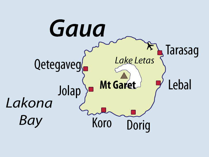
Gaua [gawa] (formerly known as Santa Maria Island) is the largest and second most populous of the Banks Islands in Torba Province in northern Vanuatu. It covers 342 km2.
Gaua is subject to frequent earthquakes and cyclones. The climate is humid tropical; the average annual rainfall exceeds 3500 mm. It has rugged terrain, reaching up to Mount Gharat (797 m), the peak of the active stratovolcano which lies at the center of the island. Its most recent eruption was in 2013. The volcano has a 6 × 9 km caldera, within which lies a crater lake, known as Lake Letas, which is the largest lake in Vanuatu. To the east of the lake is Siri Waterfall (120 m drop).
Gaua's geology is fairly typical of an immature volcanic island arc. The oldest part of the island is the southwestern corner, which consists largely of primitive basalts and ankaramites. Most of the island is covered by the Santa Maria Pyroclastic Series, a mafic ignimbrite unit that was produced by the eruption that formed the caldera. Gaua is rare in hosting a mafic ignimbrite, as most similarly explosive eruptions are more silicic; other examples include Masaya in Nicaragua, and on Ambrym, and Tanna, also in Vanuatu. The eruption of the SMPS was also associated with the activation of ring faults, and the production of parasitic volcanic cones around the upper slopes of the volcano.
The upper slopes of the island have been recognised as an Important Bird Area (IBA) by BirdLife International, because they support populations of Vanuatu megapodes, Vanuatu imperial pigeons, Tanna fruit doves, red-bellied fruit doves, palm lorikeets, cardinal myzomelas, fan-tailed gerygones, long-tailed trillers, streaked fantails, Melanesian flycatchers, southern shrikebills, Vanuatu white-eyes, and red-headed parrotfinches. Other animals found there include long-tailed fruit bats, Vanuatu flying foxes, and coconut crabs.
In 2009, the island had a population of 2,491, and an annual growth rate of 2.0 percent. The inhabitants are scattered among various coastal villages on the western, southern and northeastern sides of the island. The eastern side has a few hamlets with an immigrant community, the members of which have come from the two smaller islands Merig and Merelava, that lie southeast of Gaua. The largest village on Gaua is Jolap [ʧʊlap], on the west coast.
In addition to Mwerlap (the language of the immigrant population), there are five languages traditionally spoken on Gaua: Lakon (also called Vuré), Olrat, Koro, Dorig, and Nume.
The livelihood of the people of Gaua is based on the agricultural economy that is traditional throughout of Melanesia: a combination of fishing and horticulture. Their principal exports are copra and cacao.
The island is served by Gaua Airport, which is located in the northeast corner of the island.
Hub AI
Gaua AI simulator
(@Gaua_simulator)
Gaua
Gaua [gawa] (formerly known as Santa Maria Island) is the largest and second most populous of the Banks Islands in Torba Province in northern Vanuatu. It covers 342 km2.
Gaua is subject to frequent earthquakes and cyclones. The climate is humid tropical; the average annual rainfall exceeds 3500 mm. It has rugged terrain, reaching up to Mount Gharat (797 m), the peak of the active stratovolcano which lies at the center of the island. Its most recent eruption was in 2013. The volcano has a 6 × 9 km caldera, within which lies a crater lake, known as Lake Letas, which is the largest lake in Vanuatu. To the east of the lake is Siri Waterfall (120 m drop).
Gaua's geology is fairly typical of an immature volcanic island arc. The oldest part of the island is the southwestern corner, which consists largely of primitive basalts and ankaramites. Most of the island is covered by the Santa Maria Pyroclastic Series, a mafic ignimbrite unit that was produced by the eruption that formed the caldera. Gaua is rare in hosting a mafic ignimbrite, as most similarly explosive eruptions are more silicic; other examples include Masaya in Nicaragua, and on Ambrym, and Tanna, also in Vanuatu. The eruption of the SMPS was also associated with the activation of ring faults, and the production of parasitic volcanic cones around the upper slopes of the volcano.
The upper slopes of the island have been recognised as an Important Bird Area (IBA) by BirdLife International, because they support populations of Vanuatu megapodes, Vanuatu imperial pigeons, Tanna fruit doves, red-bellied fruit doves, palm lorikeets, cardinal myzomelas, fan-tailed gerygones, long-tailed trillers, streaked fantails, Melanesian flycatchers, southern shrikebills, Vanuatu white-eyes, and red-headed parrotfinches. Other animals found there include long-tailed fruit bats, Vanuatu flying foxes, and coconut crabs.
In 2009, the island had a population of 2,491, and an annual growth rate of 2.0 percent. The inhabitants are scattered among various coastal villages on the western, southern and northeastern sides of the island. The eastern side has a few hamlets with an immigrant community, the members of which have come from the two smaller islands Merig and Merelava, that lie southeast of Gaua. The largest village on Gaua is Jolap [ʧʊlap], on the west coast.
In addition to Mwerlap (the language of the immigrant population), there are five languages traditionally spoken on Gaua: Lakon (also called Vuré), Olrat, Koro, Dorig, and Nume.
The livelihood of the people of Gaua is based on the agricultural economy that is traditional throughout of Melanesia: a combination of fishing and horticulture. Their principal exports are copra and cacao.
The island is served by Gaua Airport, which is located in the northeast corner of the island.
Recent media