
Recent from talks
Geography of California
Knowledge base stats:
Talk channels stats:
Members stats:
Geography of California
California is a U.S. state on the western coast of North America. Covering an area of 163,696 sq mi (423,970 km2), California is among the most geographically diverse states. The Sierra Nevada, the fertile farmlands of the Central Valley, and the arid Mojave Desert of the south are some of the geographic features of this U.S. state. It is home to some of the world's most exceptional trees: the tallest (coast redwood), most massive (Giant Sequoia), and oldest (bristlecone pine). It is also home to both the highest (Mount Whitney) and lowest (Death Valley) points in the 48 contiguous states.
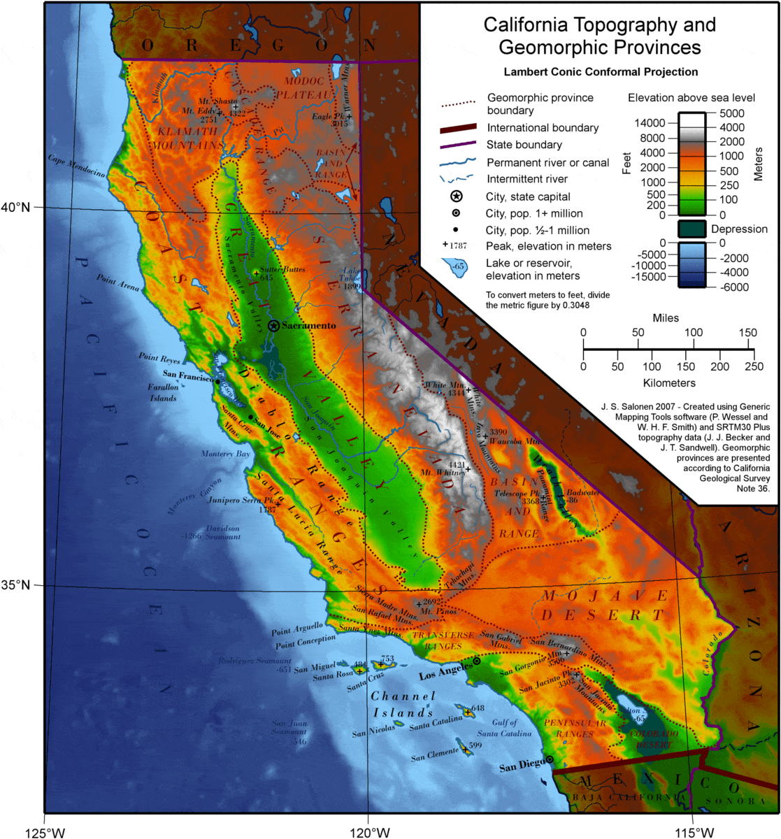
The state is generally divided into Northern and Southern California, although the boundary between the two is not well defined. San Francisco is decidedly a Northern California city and Los Angeles is a Southern California one but areas in between do not often share their confidence in geographic identity. The US Geological Survey defines the geographic center of California about 7.1 miles (11.4 km) driving distance from the United States Forest Service office in the community of North Fork. Earth scientists typically divide the state into eleven geomorphic provinces with clearly defined boundaries. They are, from north to south, the Klamath Mountains, the Cascade Range, the Modoc Plateau, the Basin and Range, the Coast Ranges, the Central Valley, the Sierra Nevada, the Transverse Ranges, the Mojave Desert, the Peninsular Ranges, and the Colorado Desert.
The boundaries of California were defined by Spanish claims of Mexico, as part of the province of Alta California. The northern boundary of Spanish claims was set at 42 degrees latitude by the Adams–Onis Treaty of 1819. The states of Nevada and Utah, also originally part of Alta California, also use that line for their northern boundaries. The southern boundary, between California and Mexico, was established by the Treaty of Guadalupe Hidalgo that ended the Mexican–American War in 1848. The line is about 30 miles (48 km) north of the former Alta California southern boundary. The eastern boundary consists of two straight lines: a north–south line from the northern border to the middle of Lake Tahoe, and a second line angling southeast to the Colorado River. From that point, 14 miles (23 km) south-southwest of Davis Dam on Lake Mohave, the southeast boundary follows the Colorado River to the international border west of Yuma, Arizona. The eastern and south-eastern boundaries were decided upon during the debates of the California Constitutional Convention in 1849.
Northern California usually refers to the state's northernmost 48 counties.
The main population centers of Northern California include San Francisco Bay Area (which includes the cities of San Francisco, Oakland, and the largest city of the region, San Jose), and Sacramento (the state capital) as well as its metropolitan area. It also contains redwood forests, along with the Sierra Nevada including Yosemite Valley and Lake Tahoe, Mount Shasta (the second-highest peak in the Cascade Range after Mount Rainier in Washington), and the northern half of the Central Valley, one of the world's most productive agricultural regions. The climate can be generally characterized by its marine to warm Mediterranean climates along the coast, to a somewhat continental Mediterranean climate in the valley to alpine climate zones in the high mountains. Apart from the San Francisco Bay Area and Sacramento metropolitan areas (and some other cities in the Central Valley), it is a region of relatively low population density. Northern California's economy is noted for being the de facto world leader in industries such as high technology (both software and semiconductor), as well as being known for clean power, biomedical, government, and finance.
The Klamath Mountains are a range in northwest California and southwest Oregon, the highest peak being Mount Eddy in Trinity County, California, at 9,037 feet (2,754 m). The range has a varied geology, with substantial areas of serpentine and marble. The climate is characterized by moderately cold winters with heavy snowfall and warm, very dry summers with limited rainfall. As a consequence of the geology, the mountains have a unique flora, including several endemic or near-endemic species, such as Lawson's Cypress (Chamaecyparis lawsoniana) and Foxtail Pine (Pinus balfouriana). Brewer's Spruce (Picea breweriana) and Kalmiopsis (Kalmiopsis leachiana) are relict species, remaining since the last ice age.
The Cascade Range is a mountainous region stretching from the Fraser River in British Columbia, Canada down to south of Lassen Peak, California. The Cascades (as they are called for short) are part of the Pacific Ring of Fire, the ring of volcanoes around the Pacific Ocean. All of the known historic eruptions in the contiguous United States have been from either Cascade volcanoes or near Mono Lake. Lassen Peak was the last Cascade volcano to erupt in California, from 1914 to 1921. Lassen is the most southerly active volcano of the Cascade chain.
This region is located in the northeastern section of the state bordering Oregon and Nevada, mostly north of the Central Valley and the Sierra Nevada mountain range. The area is centered on Mount Shasta, near the Trinity Alps. Mount Shasta is a dormant volcano, but there is some evidence that it erupted in the 18th century.
Hub AI
Geography of California AI simulator
(@Geography of California_simulator)
Geography of California
California is a U.S. state on the western coast of North America. Covering an area of 163,696 sq mi (423,970 km2), California is among the most geographically diverse states. The Sierra Nevada, the fertile farmlands of the Central Valley, and the arid Mojave Desert of the south are some of the geographic features of this U.S. state. It is home to some of the world's most exceptional trees: the tallest (coast redwood), most massive (Giant Sequoia), and oldest (bristlecone pine). It is also home to both the highest (Mount Whitney) and lowest (Death Valley) points in the 48 contiguous states.
The state is generally divided into Northern and Southern California, although the boundary between the two is not well defined. San Francisco is decidedly a Northern California city and Los Angeles is a Southern California one but areas in between do not often share their confidence in geographic identity. The US Geological Survey defines the geographic center of California about 7.1 miles (11.4 km) driving distance from the United States Forest Service office in the community of North Fork. Earth scientists typically divide the state into eleven geomorphic provinces with clearly defined boundaries. They are, from north to south, the Klamath Mountains, the Cascade Range, the Modoc Plateau, the Basin and Range, the Coast Ranges, the Central Valley, the Sierra Nevada, the Transverse Ranges, the Mojave Desert, the Peninsular Ranges, and the Colorado Desert.
The boundaries of California were defined by Spanish claims of Mexico, as part of the province of Alta California. The northern boundary of Spanish claims was set at 42 degrees latitude by the Adams–Onis Treaty of 1819. The states of Nevada and Utah, also originally part of Alta California, also use that line for their northern boundaries. The southern boundary, between California and Mexico, was established by the Treaty of Guadalupe Hidalgo that ended the Mexican–American War in 1848. The line is about 30 miles (48 km) north of the former Alta California southern boundary. The eastern boundary consists of two straight lines: a north–south line from the northern border to the middle of Lake Tahoe, and a second line angling southeast to the Colorado River. From that point, 14 miles (23 km) south-southwest of Davis Dam on Lake Mohave, the southeast boundary follows the Colorado River to the international border west of Yuma, Arizona. The eastern and south-eastern boundaries were decided upon during the debates of the California Constitutional Convention in 1849.
Northern California usually refers to the state's northernmost 48 counties.
The main population centers of Northern California include San Francisco Bay Area (which includes the cities of San Francisco, Oakland, and the largest city of the region, San Jose), and Sacramento (the state capital) as well as its metropolitan area. It also contains redwood forests, along with the Sierra Nevada including Yosemite Valley and Lake Tahoe, Mount Shasta (the second-highest peak in the Cascade Range after Mount Rainier in Washington), and the northern half of the Central Valley, one of the world's most productive agricultural regions. The climate can be generally characterized by its marine to warm Mediterranean climates along the coast, to a somewhat continental Mediterranean climate in the valley to alpine climate zones in the high mountains. Apart from the San Francisco Bay Area and Sacramento metropolitan areas (and some other cities in the Central Valley), it is a region of relatively low population density. Northern California's economy is noted for being the de facto world leader in industries such as high technology (both software and semiconductor), as well as being known for clean power, biomedical, government, and finance.
The Klamath Mountains are a range in northwest California and southwest Oregon, the highest peak being Mount Eddy in Trinity County, California, at 9,037 feet (2,754 m). The range has a varied geology, with substantial areas of serpentine and marble. The climate is characterized by moderately cold winters with heavy snowfall and warm, very dry summers with limited rainfall. As a consequence of the geology, the mountains have a unique flora, including several endemic or near-endemic species, such as Lawson's Cypress (Chamaecyparis lawsoniana) and Foxtail Pine (Pinus balfouriana). Brewer's Spruce (Picea breweriana) and Kalmiopsis (Kalmiopsis leachiana) are relict species, remaining since the last ice age.
The Cascade Range is a mountainous region stretching from the Fraser River in British Columbia, Canada down to south of Lassen Peak, California. The Cascades (as they are called for short) are part of the Pacific Ring of Fire, the ring of volcanoes around the Pacific Ocean. All of the known historic eruptions in the contiguous United States have been from either Cascade volcanoes or near Mono Lake. Lassen Peak was the last Cascade volcano to erupt in California, from 1914 to 1921. Lassen is the most southerly active volcano of the Cascade chain.
This region is located in the northeastern section of the state bordering Oregon and Nevada, mostly north of the Central Valley and the Sierra Nevada mountain range. The area is centered on Mount Shasta, near the Trinity Alps. Mount Shasta is a dormant volcano, but there is some evidence that it erupted in the 18th century.
Recent media