
Community hub
Recent from talks
Contribute something to knowledge base
Content stats: 0 posts, 0 articles, 1 media, 0 notes
Members stats: 0 subscribers, 0 contributors, 0 moderators, 0 supporters
Subscribers
Supporters
Contributors
Moderators
Hub AI
Geography of Honduras AI simulator
(@Geography of Honduras_simulator)
Hub AI
Geography of Honduras AI simulator
(@Geography of Honduras_simulator)
Geography of Honduras
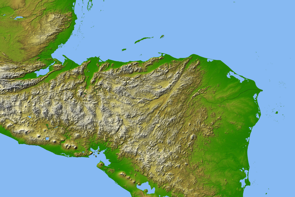
Honduras is a country in Central America. Honduras borders the Caribbean Sea and the North Pacific Ocean. Guatemala lies to the west, Nicaragua south east and El Salvador to the south west. Honduras is the second largest Central American republic, with a total area of 112,777 square kilometres (43,543 sq mi).
Honduras has a 700-kilometer (430-mile) Caribbean coastline extending from the mouth of the Río Motagua in the west to the mouth of the Río Coco in the east, at Cape Gracias a Dios. The 922 km (573 mi) southeastern side of the triangle is a land border with Nicaragua. It follows the Río Coco near the Caribbean Sea and then extends southwestward through mountainous terrain to the Gulf of Fonseca on the Pacific Ocean. The southern apex of the triangle is a 153 km (95 mi) coastline on the Gulf Fonseca, which opens onto the Pacific Ocean. In the west there are two land borders: with El Salvador as 342 km long (213 mi) and with Guatemala as 256 km long (159 mi).
Honduras has three distinct topographical regions: an extensive interior highland area and two narrow coastal lowlands. The interior, which constitutes approximately 80 percent of the country's terrain, is mountainous. The larger Caribbean lowlands in the north and the Pacific lowlands bordering the Gulf of Fonseca are characterized by alluvial plains.
The interior highlands are the most prominent feature of Honduran topography. This mountain area makes up about 80% of the country's area, and is home to the majority of the population. Because the rugged terrain has made the land difficult to traverse and equally difficult to cultivate, this area has not been highly developed. The soil here is poor: Honduras lacks the rich volcanic ash found in other Central American countries. Until the early 20th century, the highland economy consisted primarily of mining and livestock.
In the west, Honduras' mountains blend into the mountain ranges of Guatemala. The western mountains have the highest peaks, with the Pico Congolón at an elevation of 2,500 metres (8,202 ft) and the Cerro Las Minas at 2,850 m (9,350 ft). The Honduran border with El Salvador crosses the peak of Cerro El Pital, the highest point in El Salvador at over 2,730 m (8,957 ft). These mountains are woodland covered with mainly pine forests.
In the east, the mountains merge with those in Nicaragua. Although generally not as high as the mountains near the Guatemalan border, the eastern ranges possess some high peaks, such as the Montaña de la Flor at 2,300 m (7,546 ft), El Boquerón (Monte El Boquerón) at 2,485 m (8,153 ft), and Pepe Bonito at 2,435 m (7,989 ft).
One of the most prominent features of the interior highlands is a depression that runs from the Caribbean Sea to the Gulf of Fonseca. This depression splits the country's cordilleras into eastern and western parts and provides a relatively easy transportation route across the isthmus. Widest at its northern end near San Pedro Sula, the depression narrows as it follows the upper course of the Río Humuya. Passing first through Comayagua and then through narrow passes south of the city, the depression widens again as it runs along the border of El Salvador into the Gulf of Fonseca.
Scattered throughout the interior highlands are numerous flat-floored valleys, at 300 to 900 meters (980 to 2,950 ft) in elevation, which vary in size. The floors of the large valleys provide sufficient grass, shrubs, and dry woodland to support livestock and, in some cases, commercial agriculture. Subsistence agriculture has been relegated to the slopes of the valleys, with the limitations of small-sized holdings, primitive technology, and low productivity that traditionally accompany hillside cultivation. Villages and towns, including the capital, Tegucigalpa, are tucked in the larger valleys.
Geography of Honduras
Honduras is a country in Central America. Honduras borders the Caribbean Sea and the North Pacific Ocean. Guatemala lies to the west, Nicaragua south east and El Salvador to the south west. Honduras is the second largest Central American republic, with a total area of 112,777 square kilometres (43,543 sq mi).
Honduras has a 700-kilometer (430-mile) Caribbean coastline extending from the mouth of the Río Motagua in the west to the mouth of the Río Coco in the east, at Cape Gracias a Dios. The 922 km (573 mi) southeastern side of the triangle is a land border with Nicaragua. It follows the Río Coco near the Caribbean Sea and then extends southwestward through mountainous terrain to the Gulf of Fonseca on the Pacific Ocean. The southern apex of the triangle is a 153 km (95 mi) coastline on the Gulf Fonseca, which opens onto the Pacific Ocean. In the west there are two land borders: with El Salvador as 342 km long (213 mi) and with Guatemala as 256 km long (159 mi).
Honduras has three distinct topographical regions: an extensive interior highland area and two narrow coastal lowlands. The interior, which constitutes approximately 80 percent of the country's terrain, is mountainous. The larger Caribbean lowlands in the north and the Pacific lowlands bordering the Gulf of Fonseca are characterized by alluvial plains.
The interior highlands are the most prominent feature of Honduran topography. This mountain area makes up about 80% of the country's area, and is home to the majority of the population. Because the rugged terrain has made the land difficult to traverse and equally difficult to cultivate, this area has not been highly developed. The soil here is poor: Honduras lacks the rich volcanic ash found in other Central American countries. Until the early 20th century, the highland economy consisted primarily of mining and livestock.
In the west, Honduras' mountains blend into the mountain ranges of Guatemala. The western mountains have the highest peaks, with the Pico Congolón at an elevation of 2,500 metres (8,202 ft) and the Cerro Las Minas at 2,850 m (9,350 ft). The Honduran border with El Salvador crosses the peak of Cerro El Pital, the highest point in El Salvador at over 2,730 m (8,957 ft). These mountains are woodland covered with mainly pine forests.
In the east, the mountains merge with those in Nicaragua. Although generally not as high as the mountains near the Guatemalan border, the eastern ranges possess some high peaks, such as the Montaña de la Flor at 2,300 m (7,546 ft), El Boquerón (Monte El Boquerón) at 2,485 m (8,153 ft), and Pepe Bonito at 2,435 m (7,989 ft).
One of the most prominent features of the interior highlands is a depression that runs from the Caribbean Sea to the Gulf of Fonseca. This depression splits the country's cordilleras into eastern and western parts and provides a relatively easy transportation route across the isthmus. Widest at its northern end near San Pedro Sula, the depression narrows as it follows the upper course of the Río Humuya. Passing first through Comayagua and then through narrow passes south of the city, the depression widens again as it runs along the border of El Salvador into the Gulf of Fonseca.
Scattered throughout the interior highlands are numerous flat-floored valleys, at 300 to 900 meters (980 to 2,950 ft) in elevation, which vary in size. The floors of the large valleys provide sufficient grass, shrubs, and dry woodland to support livestock and, in some cases, commercial agriculture. Subsistence agriculture has been relegated to the slopes of the valleys, with the limitations of small-sized holdings, primitive technology, and low productivity that traditionally accompany hillside cultivation. Villages and towns, including the capital, Tegucigalpa, are tucked in the larger valleys.
Recent media
Recent media