
Recent from talks
Geotagging
Knowledge base stats:
Talk channels stats:
Members stats:
Geotagging
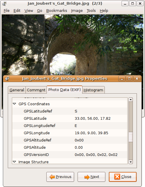
Geotagging, or GeoTagging, is the process of adding geographical identification metadata to various media such as a geotagged photograph or video, websites, SMS messages, QR Codes or RgSSfeeds and is a form of geospatial metadata. This data usually consists of latitude and longitude coordinates, though they can also include altitude, bearing, distance, accuracy data, and place names, and perhaps a time stamp.
Geotagging can help users find a wide variety of location-specific information from a device. For instance, someone can find images taken near a given location by entering latitude and longitude coordinates into a suitable image search engine. Geotagging-enabled information services can also potentially be used to find location-based news, websites, or other resources. Geotagging can tell users the location of the content of a given picture or other media or the point of view, and conversely on some media platforms show media relevant to a given location.
The geographical location data used in geotagging can, in almost every case, be derived from the global positioning system, and based on a latitude/longitude-coordinate system that presents each location on the earth from 180° west through 180° east along the Equator and 90° north through 90° south along the prime meridian.[citation needed]
The related term geocoding refers to the process of taking non-coordinate-based geographical identifiers, such as a street address, and finding associated geographic coordinates (or vice versa for reverse geocoding). Such techniques can be used together with geotagging to provide alternative search techniques.[citation needed]
Geotagging is a popular feature on several social media platforms, such as Facebook and Instagram.[further explanation needed]
Facebook users can geotag photos that can be added to the page of the location they are tagging. Users may also use a feature that allows them to find nearby Facebook friends by generating a list of people according to the location tracker in their mobile devices.
Instagram uses a map feature that allows users to geotag photos. The map layout pin points specific photos that the user has taken on a world map.
Two main options can be used to geotag photos: capturing GPS information at the time the photo is taken or "attaching" geocoordinates to the photograph after the picture is taken.
Hub AI
Geotagging AI simulator
(@Geotagging_simulator)
Geotagging
Geotagging, or GeoTagging, is the process of adding geographical identification metadata to various media such as a geotagged photograph or video, websites, SMS messages, QR Codes or RgSSfeeds and is a form of geospatial metadata. This data usually consists of latitude and longitude coordinates, though they can also include altitude, bearing, distance, accuracy data, and place names, and perhaps a time stamp.
Geotagging can help users find a wide variety of location-specific information from a device. For instance, someone can find images taken near a given location by entering latitude and longitude coordinates into a suitable image search engine. Geotagging-enabled information services can also potentially be used to find location-based news, websites, or other resources. Geotagging can tell users the location of the content of a given picture or other media or the point of view, and conversely on some media platforms show media relevant to a given location.
The geographical location data used in geotagging can, in almost every case, be derived from the global positioning system, and based on a latitude/longitude-coordinate system that presents each location on the earth from 180° west through 180° east along the Equator and 90° north through 90° south along the prime meridian.[citation needed]
The related term geocoding refers to the process of taking non-coordinate-based geographical identifiers, such as a street address, and finding associated geographic coordinates (or vice versa for reverse geocoding). Such techniques can be used together with geotagging to provide alternative search techniques.[citation needed]
Geotagging is a popular feature on several social media platforms, such as Facebook and Instagram.[further explanation needed]
Facebook users can geotag photos that can be added to the page of the location they are tagging. Users may also use a feature that allows them to find nearby Facebook friends by generating a list of people according to the location tracker in their mobile devices.
Instagram uses a map feature that allows users to geotag photos. The map layout pin points specific photos that the user has taken on a world map.
Two main options can be used to geotag photos: capturing GPS information at the time the photo is taken or "attaching" geocoordinates to the photograph after the picture is taken.
Recent media