Hubbry Logo
GithuraiGithuraiMain
Open search
Githurai
Community hub
Githurai
logo
8 pages, 0 posts
0 subscribers
Be the first to start a discussion here.
Githurai
Githurai
from Wikipedia

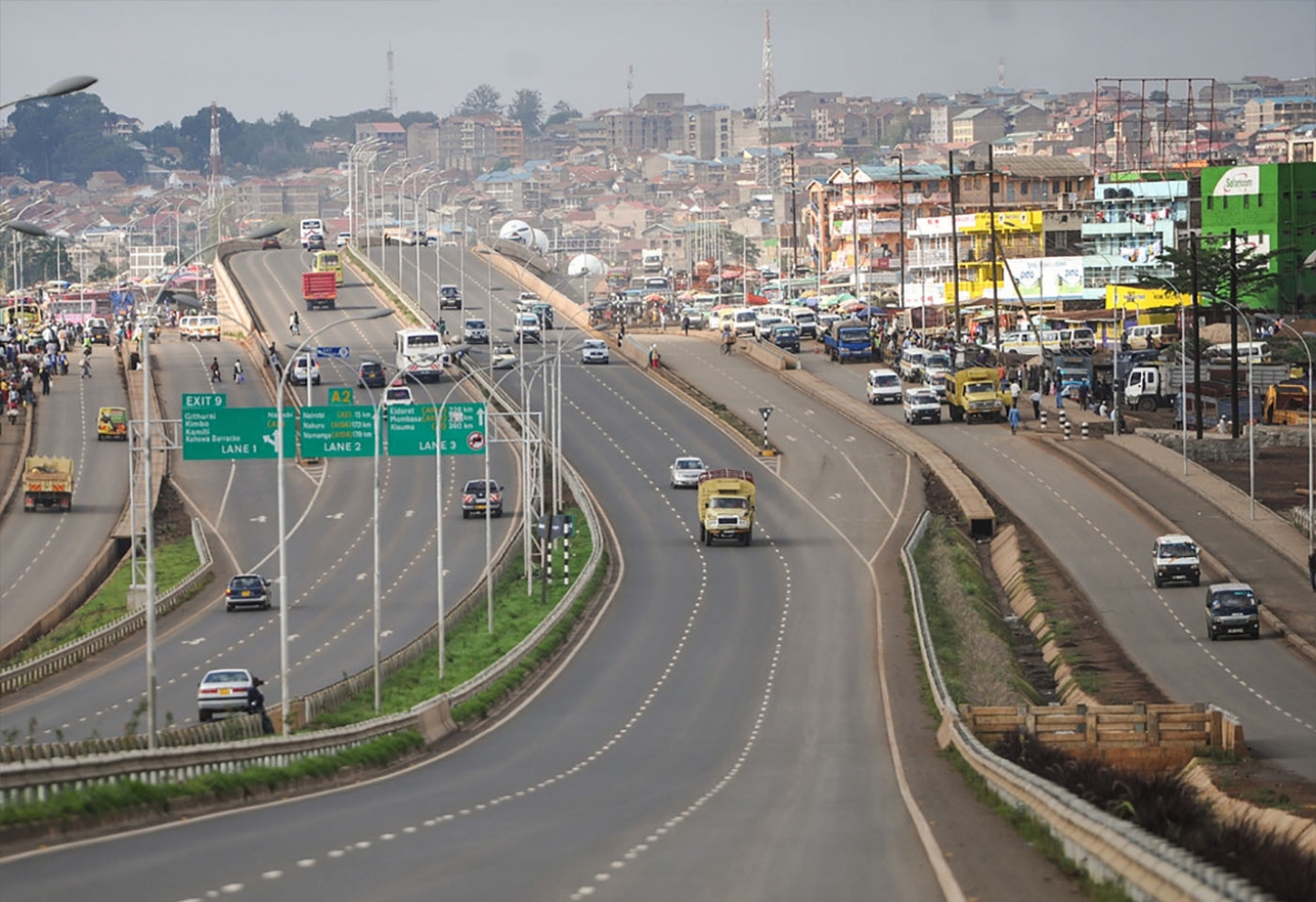
Githurai is a composition of densely populated, urban, mixed-use settlements located at the border of Nairobi County and Kiambu County along the Thika Road. Githurai is divided into two; Githurai 45 (also known as Githurai Kimbo) and Githurai 44. Githurai 45 falls under Ruiru Municipality in the Githurai Sub-county of Kiambu County with the boundary being the Thika Road reserve and River Kasarani (also known as River Gathara-ini) downstream. Githurai 44 is domiciled in the Kasarani Sub-county of Nairobi County. Githurai 44 neighbours Kahawa West, Zimmerman and Njatha-ini Village.

Key Information

Infrastructure

[edit]

Githurai is home to St Lucie Kiriri Girls High School and Kiriri Women's University of Science and Technology,[2] Lily Academy and St. Kizito Vocational Training Institute.[3][4] Githurai is served by the Thika Road Super Highway and a branch of the Kenya-Uganda Railway from Nairobi to Thika via Ruiru. There exists a Kenya Army Amoury belonging to the Kahawa Garrison/Barracks in Githurai Kimbo. A Githurai Shopping Centre exists.[5] Githurai Community Clinic is near, but not in Githurai.[6] Other residential areas in Nairobi include Kahawa, Kasarani, Dandora, Ongata Rongai and Ruai.[7] Githurai is extremely urban and heavily dominated by the Kikuyu tribe who are proficient in business. The presence of multiple campuses in the vicinity of the town has also increased the population exponentially.

Politics

[edit]

Githurai is widely regarded as the "gateway" to the Mount Kenya political bedrock. Politicians looking to cement their presence in the vote-rich mountain region often use the Githurai area as a launching pad for their politics.[8][9]

See also

[edit]

References

[edit]
Revisions and contributorsEdit on WikipediaRead on Wikipedia
from Grokipedia
Githurai is a densely populated urban settlement comprising residential, commercial, and mixed-use areas, situated along the Thika Superhighway at the boundary between Nairobi County and Kiambu County in Kenya, roughly 15 kilometers northeast of Nairobi's central business district. The area, divided into sections such as Githurai 44 and 45, functions primarily as a dormitory suburb for Nairobi workers, with a 2019 census population for its sub-locations estimated at 265,863 by local summaries referencing Kenya National Bureau of Statistics data. Its economy revolves around informal trade, including bustling markets and matatu transport hubs that facilitate daily commuting, contributing to a 24-hour operational rhythm amid low-income conditions and high entrepreneurial activity. Githurai exemplifies rapid peri-urban growth in Kenya, marked by infrastructure developments like modern markets alongside persistent challenges from overcrowding, limited services, and periodic unrest tied to broader national protests.

Geography and Location

Boundaries and Topography

Githurai straddles the administrative boundary between and , with its southern section, Githurai 44, falling under Nairobi's Sub-County within Roysambu Constituency, and the northern section, Githurai 45, under Kiambu's Constituency in Githurai Sub-County. The county boundary primarily follows the reserve and the Kasarani River, creating a jurisdictional divide that affects local governance, taxation, and service provision despite the area's seamless urban continuity. To the south and west, Githurai 44 adjoins suburbs including Kahawa West, Zimmerman, and Njatha-ini Village, while northward expansion integrates with settlements in Kiambu. Topographically, Githurai occupies a portion of the central Kenyan plateau, with an average elevation of approximately 1,542 meters above . The is predominantly flat, supporting dense urban development but featuring shallow soils that are poorly drained, contributing to occasional flooding risks during heavy rains. This level plateau-like landscape aligns with the broader region's highland characteristics, lacking significant relief variations within the immediate vicinity.

Proximity to Nairobi and Regional Context

Githurai is located approximately 15 kilometers northeast of Nairobi's central business district, accessible primarily via the A2 Thika Superhighway, a major arterial road that links the capital to northern Kenya. This proximity positions Githurai as a key commuter hub, with travel times to Nairobi CBD typically ranging from 20 to 45 minutes by matatu or bus, depending on traffic conditions. The settlement straddles the administrative boundary between Nairobi County and , with Githurai 44 situated in Nairobi's Kasarani Sub-County under Roysambu Constituency, while Githurai 45 lies in Kiambu's Ruiru Sub-County. This division reflects broader patterns of urban expansion in the Nairobi Metropolitan Region, where serves as a peri-urban extension characterized by rapid informal settlement growth and integration into Nairobi's economic orbit. In the regional context, Githurai forms part of the densely populated corridor along , facilitating connectivity to industrial zones in town, about 40 kilometers further north, and contributing to the socioeconomic ties between and the Mount Kenya agricultural heartland in and beyond. The area's strategic location has driven infrastructure investments, including the Thika Superhighway expansion completed in phases between 2012 and 2015, enhancing accessibility but also exacerbating urban pressures like congestion and informal trading.

History

Pre-Independence Origins

Prior to Kenya's in 1963, the area encompassing modern Githurai consisted primarily of a owned and operated by British colonial John Voice. This was located along the route of the corridor in District, within the fertile central highlands designated for European agricultural settlement under British Crown Lands Ordinance policies that alienated indigenous Kikuyu lands starting in the early 1900s. Such estates focused on cash-crop and production, including , to supply growing colonial urban centers like , with Thika Road itself developed as an extension of the infrastructure completed in 1901 to facilitate transport of goods and labor. The name "Githurai" likely originates from Kikuyu linguistic roots, with local accounts suggesting it arose from colonial-era instructions to African laborers dropped off at the site by white settlers to "go thurari," interpreted as "go and look for yourselves" or explore independently. Prior to intensive settler farming, the broader region featured dispersed Kikuyu agrarian communities engaged in subsistence cultivation and , though specific pre-colonial settlement patterns in the exact Githurai locale remain undocumented in available records. No formal urban or market structures existed, as the area functioned as rural farmland under colonial administration until post-independence land subdivisions initiated urban transformation.

Post-Independence Expansion and Urban Migration

Following Kenya's independence on December 12, 1963, Githurai underwent rapid expansion as a peri-urban settlement, driven primarily by rural-to-urban migration amid the lifting of colonial-era restrictions on African mobility into urban areas. This influx was exacerbated by economic disparities, with rural poverty and limited agricultural opportunities pushing migrants toward Nairobi's industrial and service sectors, particularly along the corridor where Githurai is located. Migration accounted for a substantial portion of urban in the and , outpacing natural increase in areas like Nairobi's periphery. The settlement's development was characterized by informal land occupation and , as migrants sought near hubs without formal . Proximity to —approximately 15 kilometers northeast—facilitated daily commuting via matatus and emerging road infrastructure, attracting low-wage workers to factories, markets, and construction sites. By the late , this unplanned growth had transformed Githurai into a dense mixed-use area, blending residential plots with commercial activity, though lacking adequate services due to the pace of expansion. Urban sprawl from further accelerated Githurai's population influx from the 1970s onward, with migrants from rural Central and beyond settling in informal structures on underutilized land in . This pattern reflected broader national trends, where urban population shares rose from about 7% in 1960 to over 25% by the 2000s, largely via net migration rather than internal growth alone. By 2019, Githurai's sub-locations hosted an estimated 265,863 residents, underscoring decades of sustained demographic pressure.

Demographics

Population Size and Density

According to the 2019 Kenya Population and Housing Census conducted by the Kenya National Bureau of Statistics (KNBS), the combined population of Githurai sub-locations—spanning parts of Nairobi and Kiambu counties—was 265,863. This figure encompasses Githurai 44 (in Roysambu Constituency, Nairobi County) and Githurai 45 (in Ruiru Constituency, Kiambu County), reflecting rapid urban influx driven by proximity to Nairobi's employment centers. The area of Githurai covers approximately 25.5 square kilometers, characterized by informal settlements and mixed-use development along . This yields a of about 10,425 persons per square kilometer, indicative of intense urban pressure and limited land availability for expansion. Comparable estimates from aggregated data place the 2019 population slightly lower at 262,327, underscoring the area's status as one of Nairobi's denser peri-urban zones. Post-2019 growth, aligned with Kenya's national urban increase of around 2.2% annually, suggests the current exceeds 300,000 as of 2025, though no official update exists. High exacerbates challenges like overcrowding in and strain on utilities, with much of the expansion occurring through unplanned settlements accommodating migrants from rural areas.

Ethnic and Socioeconomic Composition

Githurai's ethnic composition is dominated by the Kikuyu people, Kenya's largest ethnic group at 17.1% of the national population according to 2019 demographic profiles, owing to the area's proximity to Kikuyu ancestral regions in Kiambu County and heavy internal migration from central Kenya. As a peri-urban hub along Thika Superhighway, it also attracts diverse migrants, including Luhya (14.3% nationally) and Kamba (9.8% nationally) workers drawn to Nairobi's economic opportunities, alongside smaller communities such as Somali traders and urban refugees from Congo. Detailed ward-level ethnic breakdowns from the 2019 Kenya Population and Housing Census are not disaggregated publicly by the Kenya National Bureau of Statistics (KNBS), but constituency-level migration patterns confirm substantial inflows from Kikuyu-heavy counties like Kiambu. Socioeconomically, Githurai exemplifies low- to lower-middle-income urban living, with residents predominantly engaged in informal sector activities such as street vending, operations, and jua kali mechanics, reflecting broader peri-urban dynamics where formal employment is limited. Poverty incidence is elevated compared to 's county average of 11.4% rate in 2019, driven by high —approximately 262,327 residents in 2019—and factors like intermittent utilities, in slums such as Githurai 44 (), and inflation pressures on underclass households. Baseline assessments highlight as a core challenge, with limited access to improved sources exacerbating and productivity issues amid rapid . Wages in sectors like domestic services remain low, averaging below national urban medians, underscoring causal links to rural-urban migration without commensurate skill upgrading or infrastructure investment.

Economy

Informal Sector Dominance

The informal sector constitutes the backbone of Githurai's economy, absorbing the majority of the local workforce amid limited formal employment opportunities in this densely populated suburb. In , informal activities account for approximately 83% of total employment and contribute around 24% to national GDP, employing over 15 million people—five times more than the formal sector—predominantly in urban areas like Githurai where migration and population growth outpace industrial development. Local economic patterns mirror this national trend, with residents relying on unregulated, small-scale enterprises that thrive due to low entry barriers and proximity to major transport routes like . Key activities include street vending, hawking, and market trading at hubs like Githurai Market, which serves a extending to and supplies essentials such as fresh produce, secondhand clothing, and household goods to thousands daily. Jua kali artisans—informal mechanics, welders, and fabricators—operate roadside workshops along key intersections, capitalizing on the high volume of s (informal minibuses) and private vehicles passing through the area's matatu stages. These operations often extend into a 24-hour , driven by necessity for some residents facing chronic and by choice for others seeking flexible income streams, though this exposes workers to risks like erratic earnings and lack of legal protections. Despite efforts to formalize segments, such as the of a modern market structure completed around to consolidate vendors and boost local business, the informal sector's dominance persists due to its adaptability and the of capital-intensive formal jobs. Informal associations and social networks among workers provide mutual support, including credit and , compensating for absent state regulation, but productivity remains constrained by factors like poor and vulnerability to shocks, as evidenced during the when Nairobi's informal traders faced severe income disruptions.

Markets, Trade, and Transport Hubs

Githurai functions as a vital node in the of the metropolitan region, characterized by bustling markets and extensive networks. The Githurai 45 Market, a modern facility costing 400 million Kenyan shillings, supports up to 1,200 traders divided into seven segments: Migingo/Muiguithania, Post Bank, Kwa Nyanya, Jubilee, New Jubilee, Gateway, and Pamoja. Officially opened on August 4, 2023, by President , the market addressed longstanding trader protests and enabled over 1,000 vendors to occupy allocated stalls by November 6, 2024, under County's oversight. Trade in Githurai centers on daily commodities, with an estimated 500 vendors handling onions alone amid volatile prices that squeeze margins, as reported in October 2025. Produce often originates from regional suppliers, including in southern and in eastern , underscoring cross-border supply dependencies that expose traders to transport cost fluctuations. The area's informal trading fosters resilient , though political interference has historically delayed upgrades like the Githurai 45 facility. Transport hubs amplify Githurai's connectivity, positioning it as a key terminus along the Thika Superhighway. Route 45 links Githurai 45 directly to Nairobi's , departing from stages like Ronald Ngala opposite the Posta, with services operating every five minutes and journeys averaging 30-32 minutes. This route, integral to daily commuter flows, traverses high-traffic corridors serving northeastern suburbs and beyond, contributing to Githurai's role as a gateway despite challenges like rogue operator regulations proposed in January 2025. The Githurai Stage facilitates broader public transit integration, including bus options to areas like Ngara, reinforcing the suburb's status as a dynamic interchange for urban mobility.

Infrastructure and Urban Development

Housing and Settlement Patterns

Githurai exhibits dense, unplanned settlement patterns dominated by informal housing clusters aligned along transport arteries like Thika Superhighway and proximity to railway stations, facilitating commuter access while exacerbating overcrowding. The area's sub-locations, such as Githurai 2, record population densities reaching 26,357 persons per square kilometer, driven by rural-urban migration and limited formal land allocation. Informal settlements like Githurai village and typify these patterns, with spanning roughly 13 acres yet accommodating approximately 10,000 residents, yielding extreme densities of over 700 persons per acre. stock primarily features low-rise tenements and single-room rentals, often built incrementally using affordable materials including corrugated iron sheets for roofing and walls made of , wood, or stone blocks. In encompassing Kiambu County portions, 48.3% of dwellings use stone walls, 4.8% mud or wood, and 87.5% corrugated iron roofs, though informal zones prioritize temporary mabati (iron sheet) structures and kiosks that frequently encroach on public reserves. Rental tenure prevails, with tenants occupying shared facilities like flush toilets and septic systems, underscoring the informal sector's role in absorbing low-income populations amid constrained formal housing supply. This configuration sustains high vulnerability to environmental hazards and infrastructural deficits, as evidenced by indicators including child labor in settlement peripheries.

Utilities and Basic Services

Water supply in Githurai is managed primarily by the Nairobi City Water and Sewerage Company (NCWSC) for core areas, with extensions handled by the Ruiru-Juja Water and Sewerage Company (RUJUWASCO) in peripheral wards like Githurai 44 and 45, but coverage remains limited due to high losses exceeding 40% from leaks and theft, alongside erratic distribution pressures. Residents frequently face shortages, relying on vendors, boreholes, or contaminated surface sources like the Ruiru River, which exacerbates health risks including diarrhea cases linked to poor , , and hygiene (WASH) practices in 58% of informal settlement incidents. Mitigation efforts include the Sh300 million RUJUWASCO-led Ruiru-Juja-Githurai project initiated in 2021, which extended reticulation to over 50,000 residents in Mwihoko A and B through new pipelines funded partly by the Nairobi Satellite Towns Water and Sanitation Development Programme, though implementation lags due to revenue collection shortfalls. Sanitation infrastructure is severely deficient, with sewerage connectivity below 20% in the Metropolitan Area as of 2020, leading to widespread use of pit latrines, septic tanks, and in denser informal zones, resulting in frequent overflows, leaks, and odors reported by over 51% of low-income households. Githurai records Kenya's highest annual incidences, attributable to contaminated water sources and inadequate waste disposal, compounded by unpassable roads during rains that hinder service access. Proposed solutions include simplified systems and pilots under RUJUWASCO strategies, but enforcement of regulations remains weak amid rapid densification. Electricity access, supplied by (), reaches approximately 75% of Kenya's population nationally as of 2025, with urban suburbs like Githurai benefiting from higher grid proximity, yet informal settlements endure frequent outages—often lasting days—due to overloaded transformers, , and illegal connections that strain the network. 's Last Mile Connectivity Project has targeted low-income since 2016, installing poles and transformers in peri-urban areas including Githurai extensions, but resident complaints highlight persistent blackouts in zones like Githurai 45, linked to exceeding 2,300 MW citywide in 2025. Solid waste management lags, with informal dumping prevalent and formal collection by county services covering under half of households, contributing to and disease vectors in flood-prone sections.

Roads and Public Transport

Githurai's road network is anchored by the , an 8-lane dual carriageway forming part of Kenya's A2 highway that links to over approximately 50 kilometers. This , expanded between 2008 and 2012 at a cost of KSh 32 billion, includes sections widened to 12 lanes and features interchanges to alleviate bottlenecks. The highway divides Githurai into sections 44 (in ) and 45 (in , near ), with the roadway serving as a boundary that complicates pedestrian crossings and local access. Public transport in Githurai relies heavily on matatus, unregulated minibuses operating on numbered routes from 's . Route 45 matatus, boarding along Ronald Ngala Street opposite the , provide frequent service to Githurai via the Thika Superhighway, connecting residential areas to employment hubs in the city center. Services run every few minutes during peak hours, with fares around $1 for trips to stages like Ngara, though travel times average 30 minutes amid variable conditions. Traffic challenges persist despite upgrades from the Nairobi-Thika Highway Improvement Project, which aimed to enhance urban mobility along the corridor. The highway experiences recurrent congestion, particularly between Muthaiga and Githurai, exacerbated by accidents such as bus overturns and pedestrian collisions at black spots like Githurai 45. Vehicle-to-pedestrian incidents dominate safety concerns, with barriers and diversions occasionally implemented following protests or spills, further disrupting matatu operations and commuter flows. Local efforts, including community-led traffic management during closures, highlight reliance on informal resolutions amid strained formal policing.

Social Issues

Poverty and Its Causal Factors

Githurai, an informal settlement in , displays pronounced poverty indicators despite the county's overall poverty rate of 19.9% in 2022, including high , child labor, , drug abuse, elevated school dropout rates, and restricted healthcare access. These conditions persist amid rapid , from 80,775 residents in 2015 to a projected 190,239 by 2030, straining local resources and amplifying deprivation. A core causal factor is overwhelming reliance on the informal sector for livelihoods, where residents engage in unstable, low-productivity activities such as small-scale trading, jua kali , and services, yielding insufficient income to escape traps. This dependency arises from limited formal job opportunities, exacerbated by rural-urban migration that floods the area with low-skilled labor outpacing economic absorption capacity. compounds the issue, fostering idleness and pushing individuals toward as a mechanism, as evidenced by a analysis linking poverty-driven joblessness in Githurai to heightened criminality. Inadequate further entrenches by inflating living costs and curtailing economic participation; poorly maintained roads become impassable during rains, causing flooding, business disruptions, and issues like respiratory infections, while limiting access to markets, schools, and employment hubs in nearby . Low and skills mismatches perpetuate intergenerational transmission, as dropouts enter the workforce unprepared for higher-value roles, sustaining a cycle of low and dependency.

Crime, Security, and Community Dynamics

Githurai is recognized as one of 's high-crime neighborhoods, with prevalent incidents of muggings, armed robberies, and burglaries, particularly along major routes like . Local police assessments identify Githurai as a key area for street-level and violent assaults, driven by its dense population and informal economic activities that facilitate opportunistic crimes. Official data from Nairobi County indicates that stealing and rank among the most perceived crimes, with rates exceeding national averages in urban fringes like Githurai. Recent violent episodes underscore the persistence of with violence. In February 2025, two officers from Githurai Police Post were arrested alongside a civilian accomplice during an attempted along the Githurai-Soweto route, highlighting internal security challenges within . Similarly, on August 25, 2025, a 21-year-old man was fatally stabbed during a in Githurai Kimbo, prompting investigations into involvement. Such cases reflect broader patterns where perpetrators, sometimes including rogue elements from security forces, exploit vulnerabilities in high-traffic zones. Community dynamics in Githurai revolve around self-organized security responses amid distrust in state policing, which is often viewed as under-resourced and prone to corruption. Residents in informal settlements like Githurai frequently form vigilante groups or participate in mob justice to deter thieves, as formal police protection proves inadequate in addressing everyday threats. These informal mechanisms, while providing immediate deterrence, can escalate into extrajudicial violence, with communities tolerating aggressive tactics due to chronic under-protection by official forces. Government-backed community policing initiatives exist but struggle against entrenched patterns of ethnic homogeneity fostering localized militias over coordinated state efforts.

Education, Health, and Family Structures

Githurai features several , including Githurai Primary School, which enrolled 1,850 pupils across 25 classes with 40 permanent teachers as of recent records. Other institutions, such as Lily Academy's Githurai campus, offer mixed day and boarding education under the competence-based . However, as an informal , the area mirrors broader Kenyan challenges in low secondary transition rates, with national primary-to-secondary progression below 100% in 2024 due to economic barriers and dropout factors like and early . and resource shortages contribute to suboptimal learning outcomes, exacerbating despite Kenya's adult literacy rate of 82.88% in 2022. Health services in Githurai rely on a mix of public and private facilities, including the Githurai 44 Centre for basic and Trans Marigold , located off Kamiti , offering general and specialized services. Private providers like Penda Health and Bliss Medical Centre supplement these, focusing on outpatient and maternal care in the densely populated zones. Residents in such informal settlements face elevated risks of communicable diseases due to poor and high population density, with patterns of underutilization of public facilities stemming from perceived quality issues and preference for private options despite costs. Family structures in Githurai predominantly consist of nuclear households supplemented by extended kin networks, reflecting urban Kenyan norms where average household size aligns with the national figure of 3.9 persons per household from the 2019 census. Polygamous arrangements persist among some Kikuyu-dominated communities, legalized under Kenya's 2014 Marriage Act, though they correlate with resource strain and child neglect in low-income settings. Fertility rates remain above replacement levels, contributing to larger families amid economic pressures, with extended family support aiding single mothers in informal settlements like Githurai.

Politics and Governance

Administrative Structure

Githurai's administrative framework reflects its position astride the boundary between and , resulting in bifurcated governance and service delivery. The neighborhood is segmented into Githurai 44 and Githurai 45, with the former integrated into Nairobi's urban administration and the latter forming a distinct sub-county in . This split, formalized through national gazette notices and county boundaries established post-2010 , necessitates coordination between two county governments for cross-boundary issues such as and . In , Githurai 44 operates under Sub-County within Roysambu Constituency, where Githurai Ward serves as the primary political and administrative unit. This ward, encompassing densely populated residential and commercial zones along , is headed by a ward administrator and represented by a Member of Assembly (MCA), with oversight from the sub-county deputy county commissioner for national functions. As of September 2025, the ward's MCA position became vacant following the of Deonysias Mwangi Waithira, who cited stalled development projects amid tensions with county leadership. Nairobi's structure aligns wards with locations for revenue collection and service provision, though specific sub-divisions like locations within Githurai Ward are not distinctly delineated in beyond polling and administrative offices. Githurai 45, conversely, constitutes Kiambu County's Githurai Sub-County, a unit carved out as part of the county's 12 sub-counties under the national administrative hierarchy. This sub-county includes 1 division, 3 locations, and 7 sub-locations, spanning 151.4 square kilometers and falling politically within Constituency. Governed by a deputy county commissioner for administrative matters and integrated into Municipality for , it handles local functions like land allocation and by-law enforcement separately from Nairobi's portion. The sub-county's establishment, gazetted around 2022, aimed to enhance localized administration amid rapid , though it has amplified jurisdictional disputes over shared resources.

Electoral Patterns and Tribal Influences

Githurai, as a ward within Roysambu Constituency in Nairobi County, features a predominantly composed of Kikuyu individuals, reflecting broader settlement patterns of Central Kenyan ethnic groups in peri-urban Nairobi areas. This demographic dominance fosters electoral preferences aligned with Kikuyu political interests and alliances, consistent with Kenya's national trend where ethnic identity significantly influences voter behavior, often overriding policy considerations in selection. Academic analyses of Kenyan voting indicate that ethnic loyalties account for a substantial portion of vote shares, with voters favoring co-ethnics or partners from dominant local groups. In the 2022 general elections, Roysambu Constituency, encompassing Githurai, recorded 154,711 registered voters, with 91,022 valid votes cast for the presidency; William Ruto of the Kenya Kwanza alliance secured a majority, outperforming Raila Odinga of Azimio la Umoja by a wide margin, signaling a shift toward Ruto's ticket bolstered by his Kikuyu running mate, Rigathi Gachagua. The parliamentary seat went to United Democratic Alliance (UDA) candidate Augustine Kamande Mwafrika with 45,221 votes, defeating incumbent Jubilee Party MP Isaac Waihenya Ndirangu's 40,140 votes, highlighting intra-Kikuyu competition amid the national Uhuru Kenyatta-William Ruto fallout. This outcome exemplifies how tribal alliances can redirect bloc voting, as Kikuyu voters in such areas pivoted from traditional Jubilee support to a perceived stronger ethnic representation within Kenya Kwanza. Tribal influences manifest in resistance to non-aligned candidates, as evidenced by violent disruptions during Raila Odinga's January 2021 visit to Githurai 45, where local residents protested the ODM leader's incursion into a perceived Kikuyu stronghold, underscoring limited appeal for Luo-led coalitions. Ward-level contests for Member of County Assembly similarly feature predominantly Kikuyu candidates, reinforcing ethnic homogeneity in local . While urban migration introduces some ethnic diversity, voting patterns in Githurai persist as a microcosm of Kenya's ethnic arithmetic, where coalitions incorporating Kikuyu figures dominate, though economic grievances occasionally temper strict tribal fidelity.

Government Interventions and Policy Impacts

The Kenyan national and governments have implemented infrastructure-focused interventions in Githurai, primarily through programs like the Nairobi Metropolitan Services Improvement Project (NaMSIP) and the Kiambu Integrated Slum Improvement Programme (KISIP II), targeting access roads, , and to address the area's informal settlement challenges. Under NaMSIP, of access roads to Githurai Station—spanning alignment extensions in —aimed to enhance connectivity to the Superhighway and support public-sector reforms aligned with Vision 2030 priorities. These efforts have contributed to gradual improvements in transport efficiency, reducing congestion at key junctions. Water infrastructure has seen targeted upgrades, with the commissioning of the Githurai water supply project in August 2023 providing expanded access to piped in previously underserved sections of the . This intervention, part of broader efforts, has mitigated chronic shortages that exacerbate risks in dense informal areas, though sustained remains a challenge amid rapid . Complementing this, KISIP II allocated approximately KSh 1 billion (about $7.7 million USD as of 2025 exchange rates) starting in 2024-2025 for upgrading five informal settlements in , including elements in Githurai such as paving muddy paths into modern streets, installing street lighting, and issuing title deeds to enhance tenure security. These measures have fostered incremental economic activity by improving mobility and property formalization, though community displacement risks persist, as evidenced by a May 2025 eviction notice issued by for structures on the Githurai Phase 2 development site to clear land for housing and market expansions. Broader national policies under the National Slum Upgrading and Prevention Strategy (NSUPS) 2024-2034 influence Githurai indirectly by promoting integrated approaches to land regularization, , and , building on earlier frameworks like the Kenya Slum Upgrading Programme (KENSUP). Impacts include heightened resident optimism for long-term habitability, with reports of reduced flooding and better in upgraded zones, but implementation gaps—such as uneven enforcement and funding delays—have limited scalability, perpetuating vulnerabilities in non-prioritized pockets. County's 2025-2026 Annual Development Plan further integrates Githurai-specific revenue enhancements, like modernizing the Githurai market office, to boost local fiscal capacity for ongoing projects. Overall, while these policies have yielded tangible gains, their efficacy hinges on addressing displacement concerns and ensuring equitable benefits amid Githurai's high-density demographics.

Controversies and Recent Events

2024 Finance Bill Protests and Police Response

The 2024 Finance Bill protests in Githurai, a densely populated informal settlement in Nairobi, erupted as part of nationwide demonstrations against proposed tax increases in the Finance Bill 2024, including hikes on bread, sanitary products, and digital services, aimed at raising approximately 2.7 billion Kenyan shillings for government revenue. Local residents, primarily youth, blocked roads along Thika Superhighway and engaged in chants against the legislation, viewing it as burdensome amid high living costs and youth unemployment exceeding 30 percent in urban slums. Protests intensified on June 25, 2024, coinciding with the storming of Kenya's parliament in central Nairobi, where Githurai demonstrators clashed with security forces attempting to clear barricades and restore traffic flow. Kenyan police, deployed under orders to maintain public order, responded in Githurai with canisters and to disperse crowds, as protests disrupted major transport routes and led to sporadic stone-throwing and of nearby businesses. The Independent Policing Oversight Authority (IPOA) later documented instances of officers firing live rounds in suburbs, including areas near Githurai, resulting in injuries from gunshot wounds among protesters fleeing the scene. Nationwide, at least 22 deaths were reported from June 25 clashes, with attributing several to direct police shootings into crowds, though specific Githurai fatalities remain unconfirmed beyond general injury tallies of over 200 across on that date. Police justified the force as necessary against escalating violence, including arson attempts on vehicles and , while President William Ruto's administration initially defended the response as proportionate before withdrawing the bill on June 26 amid mounting pressure. Social media amplified unverified claims of a "massacre" in Githurai, with videos and posts alleging police executed dozens or hundreds of unarmed protesters, prompting international concern and demands for investigations. A verification effort, cross-checking hospital records, eyewitness accounts, and geolocated footage from June 25-27, found no evidence supporting mass killings in the area—no mass graves, unexplained body disposals, or disproportionate death tolls at local facilities like Kenyatta National Hospital, which reported fewer than five related fatalities from Githurai. These findings highlighted the rapid spread of amid chaotic unrest, contrasting with confirmed police excesses elsewhere, such as abductions of protest leaders documented post-June by monitors. The National Commission on (KNCHR) urged accountability for any unlawful force, noting systemic issues in police and command structures, while IPOA probes continued into specific Githurai deployments as of late 2024.

Allegations of Exaggerated Violence and Media Narratives

During the anti-Finance Bill protests on June 25, 2024, clashes erupted in Githurai between demonstrators and , prompting widespread claims of a police-orchestrated "" involving dozens to over 200 civilian deaths, with unverified videos depicting bodies allegedly loaded into police trucks and disposed of secretly. These narratives rapidly amplified across platforms, attributing the supposed killings to excessive police force, including live , amid broader accusations of state repression during the protests. Subsequent investigations, including a probe involving interviews with over 20 Githurai residents, visits to local hospitals and morgues, and reviews of medical records, uncovered no substantiation for mass casualties; only four deaths were confirmed in the area that night, with two attributed to road accidents, one to a shooting unrelated to protests, and one possibly protest-linked but not part of systematic killings. Residents acknowledged violent confrontations, including the burning of a police vehicle and gunfire exchanges, but described the events as chaotic skirmishes rather than a targeted slaughter, with no evidence of body disposals or the inflated victim counts. A local social worker interviewed post-event corroborated hearing gunshots and witnessing police aggression but emphasized the absence of a , attributing higher death tolls to with nationwide fatalities. Critics, including Kenyan media analysts, alleged that initial reporting by some outlets and heavy reliance on unverified social media content constituted a failure of journalistic , exacerbating and eroding public trust in legacy media amid pressures from and post-2007 election violence sensitivities. Police statements and an internal further contradicted resident accounts of indiscriminate shootings, claiming defensive actions against stone-throwing protesters and vehicle , while noting discrepancies in casualty figures that social media had inflated without forensic or eyewitness corroboration. This episode highlighted vulnerabilities in rapid-response coverage during unrest, where sensational claims outpaced verification, potentially fueling disproportionate to documented evidence of localized violence.

References

Add your contribution
Related Hubs
User Avatar
No comments yet.