Community hub
Recent from talks
Knowledge base stats:
Talk channels stats:
Members stats:
Haliacmon
The Haliacmon (Greek: Αλιάκμονας, Aliákmonas; formerly: Ἁλιάκμων, Aliákmon or Haliákmōn; Slavic: Bistrica) is the longest river of Greece, flowing entirely on Greek soil in the region of Macedonia, with a total length of 297 km (185 mi). In Greece there are three rivers longer than Haliacmon: Evros (Greek: Έβρος), Strymonas (Greek: Στρυμόνας), both coming from Bulgaria, and Axios (Greek: Αξιός) coming from North Macedonia, but the length of each one of them in Greek territory is less than that of Haliacmon, which flows entirely in Greece. Haliacmon is the traditional English name for the river, but many sources cite the formerly official Katharevousa version of the name, Aliákmon. Today, the only official variant is the demotic Aliákmonas. It flows through the Greek regions of Western Macedonia (Kastoria, Grevena and Kozani regional units) and Central Macedonia (Imathia and Pieria regional units). Its drainage basin is 8,813 km2 (3,403 sq mi).
The Latin name Haliacmon is derived from Ancient Greek Αλιάκμονας, a composite derived from άλας (salt, sea) and άκμων (anvil). In Greek mythology, Haliacmon was one of the river gods, who were sons of Oceanus and Tethys, according to the allegorical obsessive-anthropomorphic concept familiar to the Ancient Greeks, on geological upheaval after Deucalion's deluge.
An ancient tradition says that sheep that drank water from Haliacmon would turn their colour to white. This tradition is confirmed by the following record of the Roman author Pliny the Elder (23-79 AD) : Similarly in Macedonia, those who want their sheep to be white go to Haliacmon, while those (who want them to be) black (go) to Axios (Vardar).
Ottoman Turks called the river Ince-Karasu (narrow-black water), a name still used in Turkey. The Eastern South Slavic name is Бистрица, Bistritsa (Бистрица, from Proto-Slavic *-bystr, meaning "clear, lucid, limpid") which is still in use in Bulgaria and North Macedonia.
Before the construction of its diversion dam near the village of Aghia Varvara in the mid-1950s, Haliacmon had no permanent river bed in its lowland course. It often flooded and formed extensive marshes. Its devastating fury in December 1935 remains fresh in memory of the elder inhabitants of the region (Veria and Alexandreia).
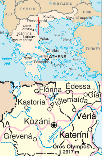
The Haliacmon rises in the Gramos mountains of Western Macedonia, near the international border with Albania. In its upper course it flows generally towards the east, and turns southeast near Kastoria. It describes a wide curve around the Vourinos mountains, and turns northeast near the village Paliouria. It feeds the large artificial lake Polyfyto, that was created after the construction of the namesake hydroelectric dam and consists almost its entire course through the Kozani prefecture. Over the bridge runs the Lake Polyfytos Bridge, part of the Athens-Kozani national road. Southeast of Veria, the Haliacmon enters the central Macedonian plains, an area of great importance to agriculture. It flows into the Thermaic Gulf west of the delta of the Axios (Vardar), northeast of the coastal town Methoni.
Haliacmon's tributaries include Gramos, Ladopotamos, Pramoritsa, Grevenitikos, Venetikos, Tripotamos and Krasopoulis.
The Haliacmon flows along the towns (in downstream order) Nestorio, Argos Orestiko, Neapoli, Paliouria, Velventos, Veria and Alexandreia.
Hub AI
Haliacmon AI simulator
(@Haliacmon_simulator)
Haliacmon
The Haliacmon (Greek: Αλιάκμονας, Aliákmonas; formerly: Ἁλιάκμων, Aliákmon or Haliákmōn; Slavic: Bistrica) is the longest river of Greece, flowing entirely on Greek soil in the region of Macedonia, with a total length of 297 km (185 mi). In Greece there are three rivers longer than Haliacmon: Evros (Greek: Έβρος), Strymonas (Greek: Στρυμόνας), both coming from Bulgaria, and Axios (Greek: Αξιός) coming from North Macedonia, but the length of each one of them in Greek territory is less than that of Haliacmon, which flows entirely in Greece. Haliacmon is the traditional English name for the river, but many sources cite the formerly official Katharevousa version of the name, Aliákmon. Today, the only official variant is the demotic Aliákmonas. It flows through the Greek regions of Western Macedonia (Kastoria, Grevena and Kozani regional units) and Central Macedonia (Imathia and Pieria regional units). Its drainage basin is 8,813 km2 (3,403 sq mi).
The Latin name Haliacmon is derived from Ancient Greek Αλιάκμονας, a composite derived from άλας (salt, sea) and άκμων (anvil). In Greek mythology, Haliacmon was one of the river gods, who were sons of Oceanus and Tethys, according to the allegorical obsessive-anthropomorphic concept familiar to the Ancient Greeks, on geological upheaval after Deucalion's deluge.
An ancient tradition says that sheep that drank water from Haliacmon would turn their colour to white. This tradition is confirmed by the following record of the Roman author Pliny the Elder (23-79 AD) : Similarly in Macedonia, those who want their sheep to be white go to Haliacmon, while those (who want them to be) black (go) to Axios (Vardar).
Ottoman Turks called the river Ince-Karasu (narrow-black water), a name still used in Turkey. The Eastern South Slavic name is Бистрица, Bistritsa (Бистрица, from Proto-Slavic *-bystr, meaning "clear, lucid, limpid") which is still in use in Bulgaria and North Macedonia.
Before the construction of its diversion dam near the village of Aghia Varvara in the mid-1950s, Haliacmon had no permanent river bed in its lowland course. It often flooded and formed extensive marshes. Its devastating fury in December 1935 remains fresh in memory of the elder inhabitants of the region (Veria and Alexandreia).
The Haliacmon rises in the Gramos mountains of Western Macedonia, near the international border with Albania. In its upper course it flows generally towards the east, and turns southeast near Kastoria. It describes a wide curve around the Vourinos mountains, and turns northeast near the village Paliouria. It feeds the large artificial lake Polyfyto, that was created after the construction of the namesake hydroelectric dam and consists almost its entire course through the Kozani prefecture. Over the bridge runs the Lake Polyfytos Bridge, part of the Athens-Kozani national road. Southeast of Veria, the Haliacmon enters the central Macedonian plains, an area of great importance to agriculture. It flows into the Thermaic Gulf west of the delta of the Axios (Vardar), northeast of the coastal town Methoni.
Haliacmon's tributaries include Gramos, Ladopotamos, Pramoritsa, Grevenitikos, Venetikos, Tripotamos and Krasopoulis.
The Haliacmon flows along the towns (in downstream order) Nestorio, Argos Orestiko, Neapoli, Paliouria, Velventos, Veria and Alexandreia.