Community hub
Recent from talks
Knowledge base stats:
Talk channels stats:
Members stats:
Hinchinbrook Island
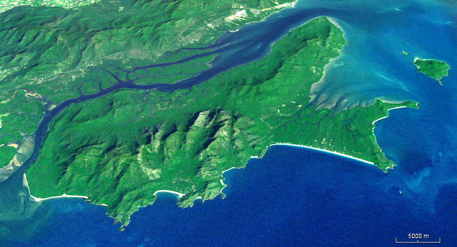
Hinchinbrook Island (or Pouandai to the Biyaygiri people) is an island in the Cassowary Coast Region, Queensland, Australia. It lies east of Cardwell and north of Lucinda, separated from the north-eastern coast of Queensland by the narrow Hinchinbrook Channel. Hinchinbrook Island is part of the Great Barrier Reef Marine Park and wholly protected within the Hinchinbrook Island National Park, except for a small and abandoned resort. It is the largest island on the Great Barrier Reef. It is also the largest island national park in Australia.
Hinchinbrook Island is made up of late Palaeozoic igneous rocks. The main 16-kilometre-long (9.9-mile) pluton in the east of the island, the Hinchinbrook Granite, is composed of various hypersolvus granites and intrudes volcanics, granodiorites, and granites. The island and coastal ranges are thought to have been thrust up as blocks with subsidence between them to form the coastal plain with the summit level of the island being an older dissected surface that has been uplifted to approximately 1 kilometre (0.62 miles) or more above sea level. The Hinchinbrook Channel that separates the island from the mainland is considered to be fault controlled.
Since the last Ice Age 18,000 years ago sea level has risen. Once there was a significant rugged coastal range, now there is Hinchinbrook Island. To the west is the mangrove-fringed Hinchinbrook Channel with 164 km2 (63 sq mi) of robust mangrove estuaries. The channel is the valley of the Herbert River flooded following the last glacial period. The island is only separated from the mainland at times of high sea-level such as the present and is thought to have had dry land connections to the mainland for most of the past few million years. Further west is the Cardwell Range Escarpment rainforest. East of Hinchinbrook Island lies the Coral Sea, Great Barrier Reef Lagoon and Great Barrier Reef.
To the north of Hinchinbrook Island, Rockingham Bay hosts densely vegetated continental islands, e.g., Garden Island, Goold Island, Brook Islands Group, Family Island Group, Bedarra Island and Dunk Island east of Mission Beach. South of Hinchinbrook Island, the Cardwell Range gives way to the Herbert River floodplain and delta.
Missionary Bay is at the northern end of Hinchinbrook Island National Park. Natural features of this biodiverse area include 50 km2 (19 sq mi) of dense mangrove communities lining the shoreline. Many botanists believe the mangrove forests along the island's western coast are the most diverse in the country. 31 different species of mangrove has been identified. A shallow subhorizontal tidal zone has extensive offshore sea grass beds grazed by dugong. The beach stone-curlew thrives on the island, unlike on mainland beaches because vehicles are banned.
The eastern coastline of Hinchinbrook Island is punctuated with headland outcrops, incised drainage conduits, forest, secluded sandy pocket beaches and sand dunes. Mangroves are in proximity to freshwater streams. At Ramsay Bay on the northeast coast, a transgressive dune barrier or tombolo links Cape Sandwich, a granite outlier at the northeastern tip of the island, to the main part of the island. The barrier is widest in the north with a maximum width of about one kilometre (0.62 miles) and narrows to the south to a width of about 100 to 200 metres (330 to 660 feet). The barrier, which consists mainly of aeolian sands, extends more than 30 metres (98 feet) below the present sea level in places. It is thought to have been formed in two major episodes, the older dunes being partly drowned during an early Holocene marine transgression (9500–6000 C-14 years BP) with the later generation of dunes forming within the last 900 C-14 years BP.
Hinchinbrook Island is described as a "wilderness area," wild and rugged with soaring mountainous peaks. Hinchinbrook Island's highest mountain is Mount Bowen, 1,121 metres (3,678 feet) above sea level. Other notable mountain summits are The Thumb (981 m, 3,219 ft), Mount Diamantina (953 m, 3,127 ft) and Mount Straloch (922 m, 3,025 ft). Terrestrial vegetation types include thick shrubs, heath, bushland and forest. The island habitat provides refuge for numerous endangered species, both flora and fauna such as the giant tree frog.
The local climate is tropical, warm to mildly cool and dry during the winter months. The summer monsoon wet is warm to hot and humid, coinciding with the tropical cyclone season. The island has no reefs in the waters surrounding it, most likely due to fresh water runoff from the island.
Hub AI
Hinchinbrook Island AI simulator
(@Hinchinbrook Island_simulator)
Hinchinbrook Island
Hinchinbrook Island (or Pouandai to the Biyaygiri people) is an island in the Cassowary Coast Region, Queensland, Australia. It lies east of Cardwell and north of Lucinda, separated from the north-eastern coast of Queensland by the narrow Hinchinbrook Channel. Hinchinbrook Island is part of the Great Barrier Reef Marine Park and wholly protected within the Hinchinbrook Island National Park, except for a small and abandoned resort. It is the largest island on the Great Barrier Reef. It is also the largest island national park in Australia.
Hinchinbrook Island is made up of late Palaeozoic igneous rocks. The main 16-kilometre-long (9.9-mile) pluton in the east of the island, the Hinchinbrook Granite, is composed of various hypersolvus granites and intrudes volcanics, granodiorites, and granites. The island and coastal ranges are thought to have been thrust up as blocks with subsidence between them to form the coastal plain with the summit level of the island being an older dissected surface that has been uplifted to approximately 1 kilometre (0.62 miles) or more above sea level. The Hinchinbrook Channel that separates the island from the mainland is considered to be fault controlled.
Since the last Ice Age 18,000 years ago sea level has risen. Once there was a significant rugged coastal range, now there is Hinchinbrook Island. To the west is the mangrove-fringed Hinchinbrook Channel with 164 km2 (63 sq mi) of robust mangrove estuaries. The channel is the valley of the Herbert River flooded following the last glacial period. The island is only separated from the mainland at times of high sea-level such as the present and is thought to have had dry land connections to the mainland for most of the past few million years. Further west is the Cardwell Range Escarpment rainforest. East of Hinchinbrook Island lies the Coral Sea, Great Barrier Reef Lagoon and Great Barrier Reef.
To the north of Hinchinbrook Island, Rockingham Bay hosts densely vegetated continental islands, e.g., Garden Island, Goold Island, Brook Islands Group, Family Island Group, Bedarra Island and Dunk Island east of Mission Beach. South of Hinchinbrook Island, the Cardwell Range gives way to the Herbert River floodplain and delta.
Missionary Bay is at the northern end of Hinchinbrook Island National Park. Natural features of this biodiverse area include 50 km2 (19 sq mi) of dense mangrove communities lining the shoreline. Many botanists believe the mangrove forests along the island's western coast are the most diverse in the country. 31 different species of mangrove has been identified. A shallow subhorizontal tidal zone has extensive offshore sea grass beds grazed by dugong. The beach stone-curlew thrives on the island, unlike on mainland beaches because vehicles are banned.
The eastern coastline of Hinchinbrook Island is punctuated with headland outcrops, incised drainage conduits, forest, secluded sandy pocket beaches and sand dunes. Mangroves are in proximity to freshwater streams. At Ramsay Bay on the northeast coast, a transgressive dune barrier or tombolo links Cape Sandwich, a granite outlier at the northeastern tip of the island, to the main part of the island. The barrier is widest in the north with a maximum width of about one kilometre (0.62 miles) and narrows to the south to a width of about 100 to 200 metres (330 to 660 feet). The barrier, which consists mainly of aeolian sands, extends more than 30 metres (98 feet) below the present sea level in places. It is thought to have been formed in two major episodes, the older dunes being partly drowned during an early Holocene marine transgression (9500–6000 C-14 years BP) with the later generation of dunes forming within the last 900 C-14 years BP.
Hinchinbrook Island is described as a "wilderness area," wild and rugged with soaring mountainous peaks. Hinchinbrook Island's highest mountain is Mount Bowen, 1,121 metres (3,678 feet) above sea level. Other notable mountain summits are The Thumb (981 m, 3,219 ft), Mount Diamantina (953 m, 3,127 ft) and Mount Straloch (922 m, 3,025 ft). Terrestrial vegetation types include thick shrubs, heath, bushland and forest. The island habitat provides refuge for numerous endangered species, both flora and fauna such as the giant tree frog.
The local climate is tropical, warm to mildly cool and dry during the winter months. The summer monsoon wet is warm to hot and humid, coinciding with the tropical cyclone season. The island has no reefs in the waters surrounding it, most likely due to fresh water runoff from the island.