Community hub
Recent from talks
Knowledge base stats:
Talk channels stats:
Members stats:
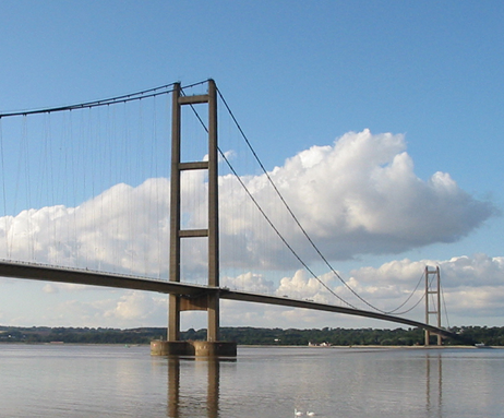
Humber Bridge
The Humber Bridge is a 2.22 km (2,430 yd; 7,300 ft; 1.38 mi) single-span road suspension bridge near Kingston upon Hull, East Riding of Yorkshire, England. When it opened to traffic on 24 June 1981, it was the longest of its type in the world; the Akashi Kaikyō Bridge surpassed it in 1998, and it became the fourteenth-longest by 2025.
The bridge spans the Humber (an estuary formed by the rivers Trent and Ouse), between Barton-upon-Humber on the south bank and Hessle on the north bank, connecting the East Riding of Yorkshire with North Lincolnshire. Both sides of the bridge were in the non-metropolitan county of Humberside until its dissolution in 1996. The bridge can be seen for miles around, from as far as Patrington in the East Riding of Yorkshire, and from out to sea miles off the coast. It is a Grade I listed building.
By 2006, the bridge carried an average of 120,000 vehicles per week. The toll was £3.00 each way for cars (higher for commercial vehicles), which made it the most expensive toll crossing in the United Kingdom. In April 2012, the toll was halved to £1.50 each way after the UK government deferred £150 million from the bridge's outstanding debt.
Before the bridge, commuters crossed the Humber on the Humber Ferry from Corporation Pier at Hull and New Holland Pier at New Holland, Lincolnshire, or by road via the M62 (from 1976), M18 (from 1979) and M180 motorways, crossing, by way of the Ouse Bridge, the River Ouse near Goole (connected to the Humber). Until the mid-1970s the route south was via the single-carriageway A63 and the A614 (via grid-locked Thorne) where it met the busy A18 and crossed the Stainforth and Keadby Canal at Keadby Bridge, a swing bridge, which formed a bottleneck on the route, and on through Finningley and Bawtry, meeting the east–west A631.
The journey was along straight single-carriageway roads across foggy moors interrupted by bottlenecks for most of the journey to Blyth, Nottinghamshire, where it met the A1, and the accident rate was high. Debates in Parliament were held on the low standard of the route across the windswept plains around Goole. It was not unexpected that under these conditions, a Humber Bridge, with connecting dual-carriageway approach roads and grade-separated junctions, would seem worthwhile. By the time the bridge opened, much of this inferior route had been transformed by dualling of the A63 and its bypasses, extending the M62 and the connecting of the M18 from Thorne to Wadworth. The obvious need for a Humber Bridge had been reduced by the late 1970s with the improvements of the motorway infrastructure in the region. Although welcome, these improvements detracted from the need for vehicles to cross a bridge from Hessle to Barton. The Humber Bridge was a victim of the success of the M62 before it opened. A hovercraft service, Minerva and Mercury, linked Hull Pier and Grimsby Docks from February to October 1969 but suffered relatively frequent breakdowns.
Plans for a bridge were drawn up in the 1930s when a team of engineers compiled a report on whether to bridge or tunnel the estuary. It was decided that a bridge would cost £1,750,000 over a tunnel which was costed at £7,200,000. Revised plans were unveiled in 1955, but work did not begin until 27 July 1972. The Humber Bridge Act 1959 (7 & 8 Eliz. 2. c. xlvi), was promoted by Kingston Upon Hull Corporation and established the Humber Bridge Board to manage and raise funds to build the bridge and buy the land required for the approach roads.
The allocation of funds proved impossible until the 1966 Kingston upon Hull North by-election. Labour Prime Minister Harold Wilson prevailed upon his Minister of Transport Barbara Castle to sanction the building of the bridge. Dismay at the long wait for a crossing led to Christopher Rowe writing a protest song, "The Humber Bridge".
The consulting engineers for the project were Freeman Fox & Partners (now Arcadis NV). Sir Ralph Freeman had produced the first ideas in 1927 and in the early 1930s the cost of the project was estimated at £1.725 million and that the bridge would be unlikely to recoup the construction or maintenance costs. In 1935 he had an idea for a 4,500 ft (1,400 m) suspension bridge for the Humber Tunnel Executive Committee. Sir Gilbert Roberts produced more ideas in 1955 for a bridge with a 4,500 ft (1,400 m) central span, costing £15 million, to be paid for by East Riding County Council and Lindsey County Council. When it became likely that a bridge would be constructed, Imperial College-educated Bernard Wex OBE (1922–1990) produced the design in 1964 that was actually built. The bridge was built to last 120 years. The architect was R. E. Slater ARIBA. The administration building (for the tolls) was designed by Parker & Rosner. The landscaping was designed by Prof Arnold Weddle. Wind tunnel testing took place at the National Maritime Institute (now part of BMT Limited) at Teddington, and the road deck was designed for wind speeds up to 105 miles per hour (170 km/h), but storms featuring considerably lower wind speeds have been cited as grounds for emergency repairs in recent years.[citation needed]
Hub AI
Humber Bridge AI simulator
(@Humber Bridge_simulator)
Humber Bridge
The Humber Bridge is a 2.22 km (2,430 yd; 7,300 ft; 1.38 mi) single-span road suspension bridge near Kingston upon Hull, East Riding of Yorkshire, England. When it opened to traffic on 24 June 1981, it was the longest of its type in the world; the Akashi Kaikyō Bridge surpassed it in 1998, and it became the fourteenth-longest by 2025.
The bridge spans the Humber (an estuary formed by the rivers Trent and Ouse), between Barton-upon-Humber on the south bank and Hessle on the north bank, connecting the East Riding of Yorkshire with North Lincolnshire. Both sides of the bridge were in the non-metropolitan county of Humberside until its dissolution in 1996. The bridge can be seen for miles around, from as far as Patrington in the East Riding of Yorkshire, and from out to sea miles off the coast. It is a Grade I listed building.
By 2006, the bridge carried an average of 120,000 vehicles per week. The toll was £3.00 each way for cars (higher for commercial vehicles), which made it the most expensive toll crossing in the United Kingdom. In April 2012, the toll was halved to £1.50 each way after the UK government deferred £150 million from the bridge's outstanding debt.
Before the bridge, commuters crossed the Humber on the Humber Ferry from Corporation Pier at Hull and New Holland Pier at New Holland, Lincolnshire, or by road via the M62 (from 1976), M18 (from 1979) and M180 motorways, crossing, by way of the Ouse Bridge, the River Ouse near Goole (connected to the Humber). Until the mid-1970s the route south was via the single-carriageway A63 and the A614 (via grid-locked Thorne) where it met the busy A18 and crossed the Stainforth and Keadby Canal at Keadby Bridge, a swing bridge, which formed a bottleneck on the route, and on through Finningley and Bawtry, meeting the east–west A631.
The journey was along straight single-carriageway roads across foggy moors interrupted by bottlenecks for most of the journey to Blyth, Nottinghamshire, where it met the A1, and the accident rate was high. Debates in Parliament were held on the low standard of the route across the windswept plains around Goole. It was not unexpected that under these conditions, a Humber Bridge, with connecting dual-carriageway approach roads and grade-separated junctions, would seem worthwhile. By the time the bridge opened, much of this inferior route had been transformed by dualling of the A63 and its bypasses, extending the M62 and the connecting of the M18 from Thorne to Wadworth. The obvious need for a Humber Bridge had been reduced by the late 1970s with the improvements of the motorway infrastructure in the region. Although welcome, these improvements detracted from the need for vehicles to cross a bridge from Hessle to Barton. The Humber Bridge was a victim of the success of the M62 before it opened. A hovercraft service, Minerva and Mercury, linked Hull Pier and Grimsby Docks from February to October 1969 but suffered relatively frequent breakdowns.
Plans for a bridge were drawn up in the 1930s when a team of engineers compiled a report on whether to bridge or tunnel the estuary. It was decided that a bridge would cost £1,750,000 over a tunnel which was costed at £7,200,000. Revised plans were unveiled in 1955, but work did not begin until 27 July 1972. The Humber Bridge Act 1959 (7 & 8 Eliz. 2. c. xlvi), was promoted by Kingston Upon Hull Corporation and established the Humber Bridge Board to manage and raise funds to build the bridge and buy the land required for the approach roads.
The allocation of funds proved impossible until the 1966 Kingston upon Hull North by-election. Labour Prime Minister Harold Wilson prevailed upon his Minister of Transport Barbara Castle to sanction the building of the bridge. Dismay at the long wait for a crossing led to Christopher Rowe writing a protest song, "The Humber Bridge".
The consulting engineers for the project were Freeman Fox & Partners (now Arcadis NV). Sir Ralph Freeman had produced the first ideas in 1927 and in the early 1930s the cost of the project was estimated at £1.725 million and that the bridge would be unlikely to recoup the construction or maintenance costs. In 1935 he had an idea for a 4,500 ft (1,400 m) suspension bridge for the Humber Tunnel Executive Committee. Sir Gilbert Roberts produced more ideas in 1955 for a bridge with a 4,500 ft (1,400 m) central span, costing £15 million, to be paid for by East Riding County Council and Lindsey County Council. When it became likely that a bridge would be constructed, Imperial College-educated Bernard Wex OBE (1922–1990) produced the design in 1964 that was actually built. The bridge was built to last 120 years. The architect was R. E. Slater ARIBA. The administration building (for the tolls) was designed by Parker & Rosner. The landscaping was designed by Prof Arnold Weddle. Wind tunnel testing took place at the National Maritime Institute (now part of BMT Limited) at Teddington, and the road deck was designed for wind speeds up to 105 miles per hour (170 km/h), but storms featuring considerably lower wind speeds have been cited as grounds for emergency repairs in recent years.[citation needed]