Hubbry Logo
HumberHumberMain
Open search
Humber
Community hub
Humber
logo
8 pages, 0 posts
0 subscribers
Be the first to start a discussion here.
Humber
Humber
from Wikipedia

Humber
A long suspension bridge over a large expanse of water
The Humber Bridge viewed from the south-east
Humber is located in Lincolnshire
Humber
Mouth of the Humber
Location
CountryEngland
Counties
CitiesKingston upon Hull
TownsBrough, Grimsby, Immingham, Barton upon Humber, Cleethorpes
Physical characteristics
Source 
 • locationTrent Falls
 • coordinates53°42′03″N 0°41′28″W / 53.7008°N 0.6911°W / 53.7008; -0.6911
Mouth 
 • location
North Sea, between Spurn Head
 • coordinates
53°32′34″N 0°05′32″E / 53.5427°N 0.0923°E / 53.5427; 0.0923
Length38.5 mi (62.0 km)[1]
Basin size24,240 km2 (9,360 sq mi)[1]
Discharge 
 • locationfreshwater inflow[1]
 • average250 m3/s (8,800 cu ft/s)[1]
 • maximum1,500 m3/s (53,000 cu ft/s)[1]
Basin features
Tributaries 
 • leftRiver Ouse, River Hull
 • rightRiver Trent, River Ancholme, River Freshney
Designation
Official nameHumber Estuary
Designated28 July 1994
Reference no.663[2]

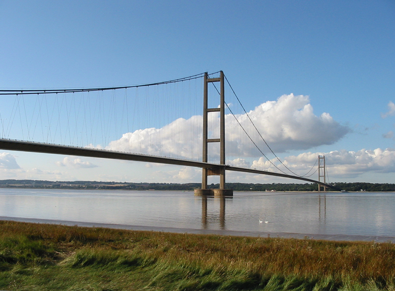
The Humber /ˈhʌmbər/ is a large tidal estuary on the east coast of Northern England. It is formed at Trent Falls, Faxfleet, by the confluence of the tidal rivers Ouse and Trent. From there to the North Sea, it forms part of the boundary between the East Riding of Yorkshire on the north bank and North Lincolnshire on the south bank. Also known as the River Humber, it is tidal its entire length.[3]

Below Trent Falls, the Humber passes the junction with the Market Weighton Canal on the north shore, the confluence of the River Ancholme on the south shore; between North Ferriby and South Ferriby and under the Humber Bridge; between Barton-upon-Humber on the south bank and Kingston upon Hull on the north bank (where the River Hull joins), then meets the North Sea between Cleethorpes on the Lincolnshire side and the long and thin headland of Spurn Head to the north.

Ports on the Humber include the Port of Hull, the Port of Grimsby and the Port of Immingham; there are lesser ports at New Holland and North Killingholme Haven. The estuary is navigable for the largest of deep-sea vessels. Inland connections for smaller craft are extensive but handle only a quarter of the goods traffic handled in the Thames.[4]

Names

[edit]

There are numerous theories for how the hydronym of Humber is derived from Celtic or Pre-Celtic languages. For example, it may be a Brittonic formation containing -[a]mb-ṛ, a variant of the element *amb meaning "moisture", with the prefix *hu- meaning "good, well" (cf. Welsh hy-, in Hywel, etc).[5]

The first element may also be *hū-, with connotations of "seethe, boil, soak", of which a variant forms the name of the adjoining River Hull.[5]

The estuary appears in some Latin sources as Abus, a name used by Edmund Spenser in The Faerie Queene. This is possibly a Latinisation of the Celtic form Aber (Welsh for river mouth or estuary) but is erroneously given as a name for both the Humber and The Ouse as one continuous watercourse.[6] Both Abus and Aber may record an older Indo-European word for water or river, (as in the 'Five Rivers' of the Punjab). An alternative derivation may be from the Latin verb abdo meaning "to hide, to conceal". The successive name Humbre/Humbri/Umbri may continue the meaning via the Latin verb umbro also meaning "to cover with shadows".[7]

Geography

[edit]
The Humber from the International Space Station

Although it is now an estuary its entire length, the Humber had a much longer freshwater course during the Ice Age, extending across Doggerland, which is now submerged beneath the North Sea.[8]

History

[edit]

The Humber features regularly in medieval British literature. In the Welsh Triads, the Humber is (together with the Thames and the River Severn) one of the three principal rivers of Britain, and is continually mentioned throughout the Brut y Brenhinedd as a boundary between the southern kingdom (Lloegyr) and various northern kingdoms. In Geoffrey of Monmouth's 12th-century historically unreliable chronicle (Historia Regum Britanniae), the Humber is named for "Humber the Hun", an invader who drowned there during battle in the earliest days of the chronicle.

The Humber remained an important boundary throughout the Anglo-Saxon period, separating Northumbria from the southern kingdoms. The name Northumbria derives from the Anglo-Saxon Norðhymbre (plural) = "the people north of the Humber".[9]

The Humber is recorded with the abbreviation Fl. Abi (The Abus river, Ancient Greek: Ἄβος) in Ptolemy's Geographia, discharging into the German Ocean (the North Sea) south of Ocelum Promontorium (Spurn Head). Ptolemy also gives the Iron Age tribes of the area as the Coritani south of the Humber and the Parisi to the north.[10][11]

In the 1719 novel Robinson Crusoe, Crusoe leaves England on a ship departing from the Humber.

On 23 August 1921, the British airship R38 crashed into the estuary near Hull, killing 44 of the 49 crew on board.[12]

From 1974 to 1996, the areas now known as the East Riding of Yorkshire, North Lincolnshire and North East Lincolnshire constituted the county of Humberside. The Humber, from 1996, forms a boundary between the East Riding of Yorkshire (to the north) and North Lincolnshire and North East Lincolnshire, to the south.

Fortifications

[edit]

The Humber Forts were built in the mouth of the estuary for the First World War. Planned in 1914, their construction started in 1915 and they were not completed until 1919.[13][14] A coastal battery at Easington, Fort Goodwin or Kilnsea Battery, faced the Bull Sands Fort.[15] They were also garrisoned during the Second World War, and were finally abandoned for military use in 1956.

Fort Paull is further upstream, a Napoleonic-era emplacement replaced in the early 20th century by Stallingborough Battery opposite Sunk Island.[16]

Crossings

[edit]

The Humber Bridge was the longest single-span suspension bridge in the world from its construction in 1981 until 1998. It is now the twelfth longest.

Before the bridge was built, a series of paddle steamers operated from the Corporation Pier railway station[17] at the Victoria Pier in Hull to the railway pier in New Holland. Steam ferries started in 1841, and in 1848 were purchased by the Manchester, Sheffield and Lincolnshire Railway. They, and their successors, ran the ferry until the bridge opened in 1981.[17] Railway passenger and car traffic continued to use the pier until the end of ferry operations.[18]

The line of the bridge is similar to an ancient ferry route from Hessle to Barton upon Humber, which is noted in the Domesday Book and in a charter of 1281. The ferry was recorded as still operating in 1856, into the railway era.[19] The Humber was then one mile (1.6 km) across.[20]

[edit]

Graham Boanas, a Hull man, is believed to be the first man to succeed in wading across the Humber since ancient Roman times. The feat in August 2005 was attempted to raise cash and awareness for the medical research charity, DebRA. He started his trek on the north bank at Brough; four hours later, he emerged on the south bank at Whitton. He is 6 feet 9 inches (2.06 m) tall and took advantage of a very low tide.[21] He replicated this achievement on the television programme Top Gear (Series 10 Episode 6) when he beat James May who drove an Alfa Romeo 159 around the inland part of the estuary in a race without using the Humber Bridge.

Swimming

[edit]

On Saturday 26 August 1911, Alice Maud Boyall became the first recorded woman to swim the Humber. Boyall, then aged 19 and living in Hull, was the Yorkshire swimming champion. She crossed the Humber from Hull to New Holland Pier swimming the distance in 50 minutes, 6 minutes slower than the existing men's record.[22]

Since 2011, Warners Health have organised the 'Warners Health Humber Charity Business Swim'. Twelve swimmers from companies across the Yorkshire region train and swim in an ellipse from the south bank to the north bank of the estuary under the Humber Bridge over a total distance of approximately 1+12 miles (2.4 km).[23] Since then, an organised group crossing at the Humber Bridge has become an annual event, with a small number of pre-selected swimmers crossing in a 'pod' which remains close together, in aid of Humber Rescue.[24]

In 2019, Hull-based competitive open water swimmer Richard Royal became the first person to attempt and complete a two-way swim across the estuary,[25] beginning and finishing at Hessle foreshore, with Barton on the south bank as the mid-way point, fulfilling the land-to-land criteria, covering a total of 4,085 m (4,467 yd). Royal holds the record for the fastest one-way swim across the Humber (35 minutes 11 seconds) and the fastest two-way swim (1 hour, 13 minutes, 46 seconds), certified by Guinness World Records and the World Open Water Swimming Association.[26] He raised over £900 for Humber Rescue, who provided safety support during the swim.

Ecology

[edit]

The Humber is home both to resident fish and those returning from the sea to their spawning grounds in Yorkshire,[27] Lincolnshire and Derbyshire. Salmon, sole, cod, eel, flounder, plaice, sprat, lamprey and sand goby have all been caught within the estuary.[28] It is also used by over-wintering birds,[29] is a good breeding ground for bitterns, marsh harriers, little terns and avocets,[30] and forms part of the Severn-Trent flyway, a route used by migratory birds to cross Great Britain.[31]

In 2019 the Yorkshire Wildlife Trust and the University of Hull re-introduced the river oyster[which?] into the Humber after a sixty-year absence.[32]

See also

[edit]

References

[edit]
[edit]
Revisions and contributorsEdit on WikipediaRead on Wikipedia
from Grokipedia
The Humber is a major tidal on the east coast of , formed at Trent Falls near Faxfleet by the confluence of the tidal Rivers Ouse and Trent, and extending approximately 62 km eastward to its mouth at Spurn Head where it meets the . As the second-largest in the and the largest on Britain's east coast, it spans about 370 km² and features a macro-tidal with high suspended concentrations derived from its feeder rivers. The Humber plays a critical role in the regional and national economy, serving as the UK's busiest port complex by tonnage handled, with key facilities at Hull, , and supporting trade, energy, and manufacturing sectors. Its surrounding low-lying lands include extensive intertidal mudflats, saltmarshes, and reedbeds that form vital habitats for migratory birds and marine species, making it a designated (SAC), (), and Ramsar site of international importance. The estuary's dynamic , influenced by strong tidal currents and fluvial inputs from the Ouse, Trent, Don, and other tributaries, has shaped its evolution over millennia, while ongoing flood management strategies address risks from tidal surges and . Historically, the Humber has been a gateway for settlement and trade since prehistoric times, with evidence of human activity dating back to the period, and it continues to influence the cultural and industrial landscape of region. Today, conservation efforts balance its ecological value—supporting diverse populations of birds, including internationally important numbers of waterfowl and waders, and unique benthic communities—with , including projects and restoration initiatives like the Alkborough Flats managed realignment scheme.

Names and Etymology

Origin of the Name

The name "Humber" originates from a Brittonic (early Celtic) compound, reconstructed as *hu-amb-ṛ, combining the prefix *hu- meaning "good" or "well," derived from Proto-Indo-European (PIE) *[h₁]su-, with *amb- denoting "moisture" or "wetness," from PIE *h₂embʰ- (related to concepts of surrounding or flowing ), and the suffix *ṛ indicating "flowing" or a river, from PIE *h₃er- (to move or flow). This form evolved through Celtic linguistic stages, reflecting prehistoric perceptions of the estuary as a beneficial, moist, and dynamic . The earliest written attestation of the name appears in Claudius Ptolemy's Geographia (c. 150 AD), where it is recorded as "Abus" (or "Fl. Abi"), identifying the as a significant feature discharging into the near the of Ocelum (modern Head). This Roman-era reference preserves the ancient , suggesting continuity from pre-Roman Celtic usage. Archaeological findings link the region's prehistoric habitation to the likely era of the name's formation, with (c. 2500–800 BC) settlements and artifacts along the Humber's banks indicating sustained human presence. Notable evidence includes the Ferriby Boats, three sewn-plank vessels discovered at on the estuary's south bank, dating to around 2000–1500 BC and representing Europe's oldest known plank-built boats, which imply advanced maritime activity tied to the waterway's role in early communities. Such sites underscore the estuary's importance in Bronze Age life, providing contextual support for the antiquity of hydronyms like *hu-amb-ṛ.

Historical and Alternative Names

During the Roman period, the Humber estuary was known as Abus Fluvius, a Latinization of the Brittonic name Abus, meaning a river or flowing water. This name appears in Ptolemy's Geography (2nd century CE), where it is listed as Abus among the rivers of , marking the boundary between tribal territories such as the to the north and the Parisi to the south. A legendary origin appears in Geoffrey of Monmouth's Historia Regum Britanniae (c. 1136), where the estuary is named after Humber, a king of the Huns who drowned there during an invasion attempt. In the Anglo-Saxon era, the Venerable Bede referred to the river in his Historia Ecclesiastica Gentis Anglorum (completed around 731 CE) as Humbre, using the genitive form to describe its role as a southern boundary for the kingdom of Northumbria. This spelling, derived from Old English Humbre, appears frequently in the text to denote geographical and political divisions, such as the extent of King Edwin's realm "from the Humber to the sea." Medieval Norse influences in the region, stemming from Viking settlements in during the 9th and 10th centuries, contributed to the stabilization and widespread adoption of the name "Humber" by the time of the in 1086. The survey records numerous settlements along the estuary, such as , using the form Humber or variants like Humbre, reflecting the integration of linguistic elements in local nomenclature amid the Danelaw's cultural impact. In the , the estuary serves as a key reference for landholdings in and , underscoring its enduring administrative significance. Local dialects, particularly in the East Riding, have historically pronounced the name as "the 'Umber," dropping the initial 'H' in a characteristic feature of the regional accent. This phonetic variation, documented in glossaries of East Yorkshire speech from the 19th and 20th centuries, persists in informal usage around Hull and the estuary's shores, distinguishing it from . In the , the name inspired the of , established on April 1, 1974, under the Local Government Act 1972, encompassing areas on both sides of the estuary including Hull, , and parts of and . The county was abolished on April 1, 1996, following recommendations by the Local Government Commission for England, which replaced it with four unitary authorities: the , , , and , restoring pre-1974 boundaries to better reflect local identities.

Geography

Physical Characteristics

The Humber Estuary forms at Trent Falls through the confluence of the tidal Rivers Ouse and Trent, extending approximately 62 km eastward to its mouth at Head. The estuary is funnel-shaped, with a width of about 1.5 km near its head, widening to roughly 13 km at the mouth. Classified as a macro-tidal , it experiences a spring tidal range of up to 7.4 m, the second largest in the . Geologically, the estuary occupies a drowned system shaped by post-glacial sea-level rise following the , when rising waters flooded ancient freshwater channels that traversed —a now-submerged lowland plain connecting Britain to . This flooding, occurring primarily between 10,000 and 6,000 years ago, transformed the pre-Holocene riverine landscape into the current environment. The estuary borders the to the north and to the south, with surrounding terrain dominated by low-lying marshes and the flat plain, a glacial landscape prone to .

Hydrology and Basin

The Humber's , encompassing the Humber River Basin District, covers an area of 26,109 km², making it the largest river basin in and draining approximately one-fifth of the country's land surface. This extensive catchment extends from the West Midlands in the south to in the north, and from the eastern to the , collecting runoff from diverse landscapes including urban, agricultural, and upland areas. The system's hydrology is characterized by an average freshwater discharge of 250 m³/s into the , with flows ranging from 60 m³/s during dry periods to peaks exceeding 1,500 m³/s during floods. Major tributaries contributing to this volume include the River Ouse (originating in , with tributaries such as the Rivers Aire, Don, and Wharfe) and the River Trent (from the ), which together channel water from catchments totaling over 20,000 km². Tidal influences extend approximately 40 miles (64 km) upstream from the mouth, affecting the lower reaches of these tributaries and creating a dynamic mixing zone where river flow interacts with brackish waters up to locations like on the Ouse and Gainsborough on the Trent. Sediment processes in the Humber are driven by high fluvial inputs and tidal resuspension, carrying over 1,500 tonnes of fine-grained material (primarily and clay) in suspension per tidal cycle and contributing to ongoing and periodic shifts in channel morphology, necessitating regular of approximately 3 million tonnes annually to maintain .

History

Prehistory and Ancient Periods

The Humber region preserves evidence of human activity dating to approximately 8000 BCE, characterized by submerged forests along the coast near Head that supported communities. These forests, exposed intermittently on the foreshore due to and tidal action, indicate a wooded, landscape rich in resources for foraging, fishing, and hunting. Archaeological artefacts, including lithic tools, from sites between and Head further attest to the exploitation of the estuary's intertidal zones by these early inhabitants. By the , around 2030–1780 BCE, maritime capabilities in the Humber area advanced significantly, as demonstrated by the Ferriby Boats discovered at on the estuary's north bank. These oak-plank vessels, sewn with withies and featuring integrated cleats for structural integrity, are the oldest known plank-built boats in the world, with Ferriby 3 confirmed by AMS radiocarbon dating to 2030–1780 cal BC at 95% confidence. The boats, originally up to 15 meters long, likely enabled cross-estuary transport and early trade networks, highlighting the Humber's role in connecting inland settlements to coastal exchanges during the Early Bronze Age. In the , the occupied the lands surrounding the , leveraging its tidal creeks and inlets for trade with across the . This tribe, associated with the distinctive Culture of square barrow burials and chariot graves, centered economic activities on iron production, with major sites like those in the yielding thousands of kilograms of slag dated 450–250 BCE. Settlements and cemeteries, such as at and , were strategically located near estuary access routes, facilitating the exchange of iron goods, currency bars, and prestige items. The functioned as a natural boundary, delineating the Parisii territory to the north from the Coritani across the southern bank. The Roman invasion elevated the Humber's strategic importance, serving initially as the province's northern frontier. In 71 CE, Governor crossed the estuary, probably at Brough-on-Humber, to launch campaigns subduing the tribe and consolidating control over northern Britain. This military advance, involving the establishment of forts and river crossings during AD 71–72, integrated the Humber into Roman , with early settlements and villas developing along its banks as the empire's limit before further northward expansion.

Medieval to Modern Developments

In the 7th and 8th centuries, the Humber served as a significant boundary in Anglo-Saxon , as described by the Venerable in his Ecclesiastical History of the English People. Bede noted that the river marked the northern limit of the dominions of King , separating the southern English kingdoms from , and later delineating the extent of Mercian overlordship under kings like Æthelbald, whose authority reached "as far as the boundary of the river Humber." This geographical division underscored the Humber's role in shaping political and ecclesiastical boundaries during the early medieval period. The Humber's strategic position facilitated major Viking incursions, most notably the arrival of in 865–866 AD. After wintering in , the Viking force advanced northward overland to capture in November 866, establishing a foothold in . This invasion fragmented Anglo-Saxon resistance, leading to the execution of rival Northumbrian kings Osberht and Ælle, and paved the way for the establishment of the —a region of Viking governance encompassing much of northern and eastern , including the Humber basin, where Scandinavian settlers introduced new legal customs and place names. By the medieval period, the Humber emerged as a vital hub, particularly through the , which was granted a by King I in 1299, renaming it and promoting its role in exports. Hull's deep-water anchorage on the Humber enabled the shipment of vast quantities of —such as 3,922 sacks in the year 1299–1300 alone—to continental markets in and beyond, fueling England's economy and establishing the estuary as a linchpin of medieval commerce. During the Wars of the Roses, the Humber's ports, including Hull, provided crucial logistical support; following the Yorkist victory at the in 1461—the bloodiest clash of the conflict, with up to 28,000 casualties—Yorkist control of the estuary secured supply lines for Edward IV's consolidation of power. The transformed the Humber into a conduit for , with coal and iron from and coalfields transported downstream from the late onward. Ports like Hull handled increasing volumes of these commodities, supporting and factories across the region and contributing to Britain's , as evidenced by the estuary's integration into nascent networks linking it to inland centers. During the Second World War, the Humber's strategic value intensified due to its role in merchant shipping and naval operations; defenses such as batteries at Spurn Point and Sunk Island protected against raids and potential invasion, while the estuary facilitated convoy assembly and Allied logistics, underscoring its importance to the war effort. In the , administrative changes redefined the Humber's governance. The county of was created in 1974 under the Local Government Act 1972, amalgamating parts of , , and northern to streamline regional administration around the estuary. However, due to local opposition, was dissolved on 1 April 1996, replaced by four unitary authorities: , , , and , which continue to manage the Humber's economic and environmental affairs independently.

Military Installations

Early Fortifications

In the , concerns over coastal threats led to the construction of defensive earthworks and batteries to safeguard key ports and navigation routes along the Humber estuary. At Hedon, a significant medieval town and former port on the north bank, urban defenses included a substantial town ditch and bank forming an earthwork enclosure, which protected the settlement and its access to Hedon Haven, a vital connected to the Humber. These earthworks, part of a encompassing the medieval town layout, were likely maintained into the to counter potential raids amid the estuary's strategic trade importance. During the in the 1640s, the Humber region saw intensified use of existing fortifications, particularly around Hull, a major Parliamentarian stronghold holding the kingdom's largest arsenal. Royalist forces under Charles I enhanced Hull's defenses between 1638 and 1642 with additional hornworks, half-moon batteries, breastworks, and an outer ditch to secure the town against parliamentary forces, though these efforts failed to capture it. Hull successfully withstood two sieges in 1642 and 1643, with the fortifications preventing enemy access via the Humber and denying sea-based resupply. Following the war, many structures were slighted—partially demolished and neglected—to prevent future military use, including the barring and later demolition of key gates like Beverley Gate by 1735. Fort Paull, on the north bank downstream from Hull, exemplifies the evolution of Humber defenses into the 19th century. Originally established in 1542 under as a battery for 12 guns to protect Hull's approaches, it was rebuilt in the 1640s under Charles I as a more substantial earthwork battery south of Paull village, only to be destroyed by Parliamentarian ships in 1643. A temporary Paull Cliff Battery followed in 1807 during the to guard against French invasion threats via the estuary's deep-water channel, but it was dismantled around 1815 after the war's end. The current pentagonal fort, constructed between 1861 and 1864 as part of the program, replaced the aging Hull Citadel and mounted 19 rifled muzzle-loading 64-pounder guns to defend the Humber's entrance, reflecting Victorian fears of naval attack. Today, Fort Paull is a visitor attraction that reopened to the public in September 2024. The Humber's strategic role in medieval trade had long exposed it to invasion risks, influencing the placement of these early defenses to control access to inland routes.

20th-Century Defenses

The Humber Forts, consisting of Bull Sand Fort and the smaller Haile Sand Fort, were constructed between 1909 and 1919 as primary sea defenses for the estuary during World War I. Bull Sand Fort, the larger structure located approximately three miles offshore from Grimsby, featured a four-story reinforced concrete design with 12-inch steel armor plating on its seaward face and was armed with four 6-inch breech-loading guns along with searchlights to counter potential German naval incursions. Haile Sand Fort, positioned nearer the south bank, was a circular, steel-armored outpost equipped with two quick-firing guns and served as a complementary battery. These offshore fortifications, built on submerged sandbanks, protected the vital ports of Hull and Grimsby from surface and submarine threats, with an anti-submarine net stretched between them to block underwater approaches. During World War II, the Humber defenses underwent significant expansions to address evolving threats, including the addition of anti-aircraft batteries along the estuary banks and boom defenses to secure the waterway against aerial and naval attacks. The forts were remanned and upgraded, with Bull Sand Fort accommodating up to 200 personnel and armed with two 6-inch guns, two 6-pounder guns, and rapid-fire weapons to support coastal artillery operations. The estuary's strategic importance extended to Allied training exercises in 1944, including river crossing maneuvers by the 1st Canadian Army Troops Engineers on the River Trent in preparation for operations following the D-Day landings. In the post-World War II period, Bull Sand Fort remained in military use until 1956, primarily for residual coastal monitoring, before the army vacated the site. The structure was sold to the Humber Conservancy Board in the early and subsequently partially demolished, leaving it abandoned and exposed to erosion. Haile Sand Fort met a similar fate, with both installations falling into disuse as offshore threats diminished. Bull Sand Fort was sold at auction in 2022. During the Cold War, monitoring stations along the Humber Estuary focused on air defense surveillance, exemplified by the RAF Holmpton Rotor Radar Station near Patrington, constructed in 1952–1953 as part of the UK's program. This underground bunker, equipped with Type 80 systems by 1958, functioned as a master station providing early warning coverage over the east coast, including the Humber approaches, and supported integration with surface-to-air missile defenses until the 1960s. The facility remained operational for training and command functions until 1992, contributing to NATO-aligned aerial threat detection amid tensions with the . As of 2025, RAF Holmpton operates as a museum open to the public.

Crossings

Bridges and Fixed Structures

The , a spanning the Humber Estuary between in and Barton-upon-Humber in , represents the primary fixed crossing over the waterway. Construction began in 1972 under the direction of consulting engineers Freeman Fox & Partners and was completed in 1981, with the bridge opening to traffic on June 24 of that year. At 1,410 meters (4,626 feet), its main span was the longest in the world for single-span suspension bridges until 1998, facilitating a vital road link that replaced earlier ferry services across the estuary. The structure carries the A15 trunk road, with four lanes and pedestrian walkways, and its design accommodates the estuary's navigational needs by providing sufficient clearance for shipping traffic. As of November 2025, tolls fund the bridge's operations and upkeep, with charges set at £1.50 for cars without a HumberTAG account (£1.35 with account), though planned increases to £2.00 without account (£1.50 with) for cars, £5.00 without (£4.00 with) for vans, and £15.00 without (£12.00 with) for heavy goods vehicles are scheduled for February 2026 to coincide with the launch of an automated tolling system delayed from late 2025, aimed at improving efficiency amid ongoing costs associated with the bridge's aging infrastructure. challenges include mitigation and structural inspections, with recent projects such as the delayed implementation of an automated tolling system in 2026 aimed at improving efficiency amid ongoing costs associated with the bridge's aging infrastructure. The bridge's endurance in harsh weather during construction and its Grade I listed status underscore its engineering significance. Minor fixed rail structures exist in association with port facilities along the estuary, such as the rail infrastructure at Dock, completed in 1912 as part of the Great Central Railway's expansion to support coal exports and dock operations on the south bank. This includes light railway lines and associated bridges over internal waterways, though no major rail bridge spans the full width of the estuary, relying instead on historical ferry connections for inter-bank . Proposals for tunnels beneath the Humber have been considered since the but largely abandoned in favor of the bridge. In 1872, an initial plan for a railway tunnel from to , estimated at £960,000, failed to advance due to financial and technical hurdles. Modern feasibility studies, including those post-2000, have focused on utility infrastructure rather than transport, such as the completed Feeder 9 gas replacement project (2018-2021), which constructed a 4.8 km beneath the to replace the aging Number 9 , addressing and ensuring supply reliability for approximately 20% of the UK's gas needs. Engineering the fixed structures across the Humber presented significant challenges due to the estuary's dynamic environment, including an unstable bed composed of deep silty sediments and a shifting deep-water channel influenced by tidal flows. Foundations for the Humber Bridge's towers and anchorages were adapted to local —Chalk on the north bank and Kimmeridge Clay on the south—using caisson techniques to minimize heave and maintain stability in soft soils, while approach viaducts required deep piling to counter instability. Tidal scour, exacerbated by strong currents and , posed risks to substructures, necessitating ongoing and protective measures to prevent around foundations in the silty . These factors, combined with the need for minimal navigational disruption, influenced the selection of suspension design over alternative fixed options.

Ferries, Swimming, and Other Methods

The Hull to ferry service, one of the oldest recorded crossings of the Humber Estuary, began operating in the following a granted by King Edward II in 1315, allowing the Warden and Burgesses of Hull to establish and toll the route. Initially powered by oars or sails, the service evolved with the introduction of steam paddle steamers in the early , facilitating the transport of passengers, horses, , and later vehicles across the from or Hull to Barton or New Holland. The route remained essential for regional connectivity until its discontinuation in June 1981, coinciding with the opening of the , which significantly reduced demand for ferry operations. In contemporary times, limited ferry services persist on the Humber, primarily international routes from Hull to the , such as the daily overnight crossing to Rotterdam's Europoort terminal, accommodating passengers, vehicles, and freight over approximately 12 hours. These services provide an alternative to fixed crossings for longer-distance travel, emphasizing comfort with onboard cabins and entertainment. across the Humber has a notable of endurance feats and recreational events, with the first recorded female crossing achieved by 19-year-old Hull swimming champion Alice Maud Boyall on 26 August 1911, completing the 6-mile (9.7 km) distance in 50 minutes from to Hull. A 1927 crossing by 19-year-old Alice Blowman from New Holland to Hull took 3 hours and 30 minutes, marking an early documented solo effort amid the estuary's strong tides and shipping traffic. Since the early , the annual Humber Swim has become a popular charity event, involving group crossings under the , often supporting organizations like Humber Rescue, with participants navigating the 1.5–4 km route depending on tidal conditions. Other non-permanent crossing methods include historical and , which were primary means during before formalized ferries, as evidenced by pre-19th-century records of small boats ferrying goods and people across the . In modern contexts, and similar small craft activities are regulated under the Humber Navigation Byelaws 1990, enforced by , requiring vessels to display lights, maintain safe speeds to avoid wash, yield to larger shipping, and obtain permissions for launches in designated areas to ensure safety amid commercial traffic.

Ecology and Biodiversity

Flora and Fauna

The Humber supports a diverse avifauna, with an average of approximately 141,600 waterbirds recorded during winter and passage periods between 2017/18 and 2021/22, including nationally and internationally important populations of waders and wildfowl. Latest Bird Survey (WeBS) up to 2023/24 indicate ongoing monitoring, though site-specific averages for recent years require further from the 2025 . Key species include the (Haematopus ostralegus), which shows variable trends with recent sharp declines after earlier increases; the (Vanellus vanellus), stable in the short term but with moderate long-term declines; and the Eurasian golden (Pluvialis apricaria), which fluctuates significantly and supports up to 40% of the site's total in key sectors like Read’s Island Flats. Passage waders such as the (Calidris canutus) utilize the mudflats, with peak occurrences representing around 3% of the north-west European population, while wintering wildfowl like the (Tadorna tadorna) remain stable and comprise over 60% of counts in southern sectors. The estuary also hosts notable numbers of whooper swans (Cygnus cygnus), with counts reaching 4,373 individuals in February counts. The fish community in the Humber Estuary includes both anadromous migrants and estuarine residents, contributing to its ecological richness. Anadromous species such as (Salmo salar) are part of broader stocks that have declined to critically low levels as of 2024, with ongoing conservation efforts focusing on habitat enhancements and management to support recovery. (Salmo trutta) similarly migrate through the estuary, with key presence during spring and summer months as part of conservation-designated populations. Estuarine residents like the (Platichthys flesus) are common, inhabiting the intertidal zones and mudflats as a key component of the local fish assemblage. Vegetation in the Humber Estuary is dominated by saltmarsh habitats, which form extensive stretches along the intertidal areas and provide critical feeding grounds. These saltmarshes feature species such as common cordgrass (Spartina anglica), a rhizomatous grass that stabilizes sediments in the mid to upper marsh zones, alongside sea lavender (Limonium vulgare), which thrives in the more saline lower marsh and adds to the floral diversity of Atlantic salt meadows. The mudflats, often fringed by these saltmarshes, serve as primary foraging areas for birds and support the overall estuarine ecosystem. Invertebrate communities are prominent in the subtidal and intertidal sediments, with notable populations in shellfish beds. Cockle beds (Cerastoderma edule) occur in areas like Horseshoe Point, where historical stocks have supported localized assemblages of bivalves and associated polychaete worms. Native European flat oysters (Ostrea edulis) have been the focus of reintroduction efforts, starting with a 2019 trial project at Spurn Point deploying initial populations to restore reef habitats and enhance . These efforts continue through the Wilder Humber project (launched 2023), which plans to reintroduce 500,000 oysters over five years using innovative remote setting techniques trialed in July 2025.

Environmental Challenges

The Humber Estuary has endured significant from industrial effluents since the , with heavy discharges from , chemical production, and urban wastewater leading to low dissolved oxygen levels, , and widespread ecological degradation throughout the . These effluents, including metals, nutrients, and organic compounds, resulted in hypoxic conditions that severely impacted aquatic life and intertidal habitats. Efforts to address this legacy intensified under the EU Water Framework Directive (WFD), which set objectives for achieving good ecological status by 2021, with extensions into the 2020s. Since 2009, over 300 sewage treatment works in the Humber River Basin District have been upgraded, supported by £520 million in investments from water companies between 2015 and 2020 to reduce point-source pollution such as ammonia and phosphates. These measures, including the Nitrate Pollution Prevention Regulations 2015, have led to moderate improvements in water quality, with ecological status at moderate for the estuary's transitional water bodies as of 2023 and enhanced habitat restoration covering 534 hectares of wetlands. Ongoing WFD monitoring in the 2020s continues to track progress, focusing on reducing nutrient loads to prevent algal blooms and support recovery of sensitive species like fish and invertebrates. Climate change poses escalating threats to the , with projected sea-level rise of approximately 1.0–1.3 meters by 2100 exacerbating tidal inundation and of coastal defenses. This rise, driven by global warming, is expected to increase risks across low-lying areas, with models indicating a shift from current 0.5% annual exceedance probability events to more frequent occurrences by mid-century under higher-emission scenarios. Storm events from 2019 to 2024, including in February 2020, have already demonstrated heightened vulnerability, causing widespread tidal ing along the estuary's shores and affecting over 1,000 properties in the Humber region. To mitigate these pressures, the Humber Estuary was designated as a Ramsar wetland site on 28 July 1994, covering 37,988 hectares to protect its international importance for migratory waterbirds and wetland ecosystems. It also forms a Special Protection Area (SPA) under the EU Birds Directive, classified in 2007 and spanning 37,630 hectares, safeguarding over 30 bird species including knot (Calidris canutus) and dunlin (Calidris alpina) that rely on its intertidal mudflats. As part of the Natura 2000 network, the site integrates these protections to address threats like pollution and habitat loss, with conservation objectives emphasizing maintenance of favorable bird populations and minimal disturbance. Post-2020 monitoring has highlighted emerging challenges, including microplastic accumulation in sediments and water, with UK-wide studies detecting up to 2,700 microplastic particles per kilogram in estuarine environments like the Humber, prompting targeted sampling under the WFD and Marine Strategy Framework Directive. Biodiversity loss remains a concern, with pressures from pollution and climate change contributing to declines in wetland habitats, though restoration initiatives such as the Wilder Humber project aim to enhance resilience by reintroducing native species—including 500,000 European flat oysters and restoring 30 hectares of seagrass meadows at Spurn Point—and monitoring key indicators like bird assemblages since 2021, with significant progress reported in 2024–2025.

Economy and Infrastructure

Ports and Shipping

The Humber estuary is home to a cluster of major ports that form one of the United Kingdom's busiest maritime complexes, facilitating extensive passenger, freight, and operations. The , located on the south bank, stands as the UK's largest port by tonnage, handling approximately 46 million tonnes of cargo each year across its deep-water berths. This port features specialized facilities such as the Immingham Container Terminal with 24/7 operations and ship-to-shore cranes for traffic, alongside the Humber International Terminal capable of accommodating vessels up to 130,000 tonnes for dry bulk handling. The , on the north bank, serves as a vital gateway for both passenger services—including regular routes to and —and freight, with enclosed cargo-handling facilities for weather-sensitive goods like steel coils and bagged products. Meanwhile, the , also on the south bank, retains strong ties to the sector, processing and importing significant volumes of , including 41.6% of the UK's total fish imports, while supporting ancillary . Navigation through the estuary demands ongoing maintenance due to its dynamic regime, with channels regularly dredged to depths of around 10 meters below to accommodate large deep-sea vessels. The Sunk Dredged Channel, providing outer access, is maintained at approximately 8.8 meters, while inner approaches to ports like and Hull are deepened as needed to support traffic exceeding 20,000 vessel movements annually. Key navigational aids include the historic Spurn Head , with records of a on the site dating to 1427 when a was granted dues for its upkeep; the current 128-foot tower, built in and decommissioned in 1985, underwent restoration in 2016 to preserve its structure as a while modern aids like buoys and vessel traffic services ensure safe passage. The ports handle a diverse range of cargoes, dominated by bulk commodities such as coal, aggregates, and oil products, alongside containerized and roll-on/roll-off traffic. Immingham, for instance, processes liquid bulks like refined oil (11.5 million tonnes in 2024) and dry bulks via dedicated terminals, while Hull supports mixed freight including forest products and metals. Since the 2010s, the estuary has emerged as a hub for offshore renewables, with ports like Hull and Immingham assembling and transporting wind turbine components for North Sea projects, leveraging their deep-water capabilities and proximity to existing and planned offshore wind farms with a total capacity exceeding 4.9 gigawatts. Overall traffic through the Humber ports reached approximately 78 million tonnes in 2023, underscoring their role in national supply chains for energy, manufacturing, and food.

Industrial and Commercial Significance

The Humber estuary serves as a hub for major industrial clusters that drive the regional economy. The Saltend Chemicals Park, located on the north bank near Hull, is one of the UK's primary chemical manufacturing sites, spanning over 370 acres and hosting multinational companies producing , polymers, and specialty chemicals, with a focus on sustainable processes including low-carbon integration. On the energy front, the Dimlington gas processing terminal (also known as Easington) near the estuary's mouth processes natural gas from fields, handling reception, treatment, and distribution to the national grid since the , supporting the 's . Further inland, the , accessed via the River Trent's confluence with the Humber, represents a key center for steel production, specializing in long products like rails and beams using from the local Lias deposits, and remains one of the last major sites for operations despite decarbonization pressures and ongoing challenges, including potential closure threats addressed by government intervention in 2025. These industries collectively underpin significant economic activity in the Humber region, supporting tens of thousands of jobs in energy-intensive sectors and contributing substantially to the GDP through , , and related supply chains. The area's industrial output benefits from its strategic , facilitating efficient of raw materials and products, with port tonnages of approximately 78 million tonnes in 2023 providing essential logistical support. In recent years, the Humber has pivoted toward renewables, exemplified by the offshore farms in the , connected to the grid via onshore infrastructure in the region; One achieved full operation in 2019 with 1.2 GW capacity, Two followed in 2022 at 1.3 GW, and Three, expected to be completed in 2027, will add 2.9 GW and establish the area as a global leader in offshore wind generation. Complementing this, post-2022 initiatives, such as the Humber H2ub project at Killingholme and the proposed linking production sites like Saltend to storage and usage points, aim to produce up to 720 MW of blue and for industrial decarbonization and export, backed by government allocation rounds. Commercial fishing has historically been vital, with serving as the world's largest fishing port by the mid-20th century, peaking in the with a fleet landing millions of tonnes of and annually before declining due to and the . Today, the focus has shifted to , with emerging as a center for land-based recirculating aquaculture systems (RAS); notable developments include a planned 5,000-tonne farm approved in 2023, with construction proceeding following resolution of legal challenges in 2025, positioning the port as a hub for production and processing.

References

Add your contribution
Related Hubs
User Avatar
No comments yet.