Recent from talks
Nothing was collected or created yet.
Hessle
View on Wikipedia
Hessle (/ˈhɛzəl/) is a town and civil parish in the East Riding of Yorkshire, England, 5 miles (8 kilometres) west of Kingston upon Hull. Geographically it is part of a larger urban area consisting of the city of Kingston upon Hull, the town of Hessle and a number of other villages but is not part of the city. It is on the north bank of the Humber Estuary where the Humber Bridge crosses.
Key Information
According to the 2011 UK census, Hessle parish had a population of 15,000,[1] an increase on the 2001 UK census figure of 14,767.[2]
Amenities
[edit]

The centre of Hessle is the Square. There are many shops and a small bus station, which was refitted in 2007. Hessle All Saints' Church is located just off the Square and was designated a Grade I listed building in 1967 and is now recorded in the National Heritage List for England, maintained by Historic England.[3] Hessle Town Hall was built in 1897 and is situated at the top of South Lane.[4] Hessle Police Station, which closed in 2014, is next door to the town hall at the top of South Lane and the corner of Ferriby Road.[5]
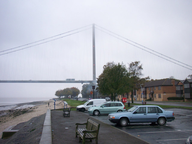
Hessle is home to the world-famous Humber Bridge, which was opened by Queen Elizabeth II in 1981. At the time of its opening, the Humber Bridge was the world's longest single-span suspension bridge. It links Hessle to the town of Barton-upon-Humber on the opposite side of the Humber estuary. In July 2017 the bridge was granted Grade I listed status.[6]
History
[edit]
The place-name 'Hessle' is first attested in the Domesday Book of 1086, where it appears as Hase. It appears as Hesla in a Danelaw Charter from the reign of Henry II between 1154 and 1189, and as Hesel in a Yorkshire Charter of 1157, and in 1242 in the Book of Fees. The name is the Old Scandinavian hesli meaning 'hazel grove'.[7]
In more modern times, Hessle has been a centre for shipbuilding. Before 1897, there was a shipyard building wooden boats, but it was then bought by Henry Scarr who moved there from Beverley, where he had previously been in partnership with his brother Joseph. Scarr produced iron and steel ships[8] until 1932, when the yard was taken over by Richard Dunston.[9] It was the largest shipyard in Hessle, building vessels such as Loch Riddon, a roll-on/roll-off ferry launched in 1986, and one of four built for Caledonian MacBrayne for use in the Hebrides.[10] The company went into liquidation in 1987 and was bought by Damen Shipyards Group in the same year. Dunston's was closed down in 1994. The location is now used as offices, car sales buildings and a dock for scrap metal and other materials for dispatch to other areas, or to be recycled. Richard Dunston's ship repairs still exists further east along the Humber Estuary, with activity remaining high.
Geography
[edit]Hessle is surrounded by the neighbouring villages of Willerby, Anlaby, Kirk Ella, West Ella, North Ferriby and Swanland.

Chalk-quarrying was a major industry at Hessle into the 20th century and quarries can still be seen in the west of the town, the largest being the Humber Bridge Country Park, which is a popular tourist attraction. Part of it is known as Little Switzerland (Little Switz or Switzy for short).
The Humber Bridge Country Park Local Nature Reserve was formerly a chalk quarry and was developed as a country park following the construction of the Humber Bridge. It consists of mixed species of woodland, wild flowers, a spring-fed pond and herb-rich grassland. The park can be explored on several well-signed walking routes.[11]
Hessle is twinned with the French town of Bourg-de-Thizy.[citation needed]
Transport to and from Hessle is convenient, with good access to main roads such as the A15, A63 and M62 (via the A63).[citation needed] It also has a railway station with hourly services to and from Hull and to destinations such as Doncaster and York.[citation needed] Regular bus services provided by East Yorkshire link the town with the surrounding villages, Hull City Centre, Longhill Estate in east Hull as well as further afield places including Brough, Beverley and the seaside resort of Hornsea.[citation needed]
Hessle is at the start of the Yorkshire Wolds Way, a long-distance footpath and designated National Trail, which crosses the Yorkshire Wolds and ends at Filey on the North Sea Coast.[citation needed]
Education
[edit]The site of the town's secondary school, Hessle High School & Sixth Form College, on Heads Lane, is centred on a building donated to the Education Authority by Algernon Henry Barkworth, a survivor of the RMS Titanic sinking. Hessle Sixth Form College is part of a consortium with secondary schools Wolfreton School (in Willerby) and Cottingham High School (in Cottingham), offering sixth form pupils a chance to attend classes at any of the three schools within the consortium. The entire school was reopened in January 2016, as part of Priority Schools Building Programme. Since January 2017, Penshurst Primary School and Hessle High School & Sixth Form College have been a through-school.
Penshurst Primary School, for children aged 3–11, located on Winthorpe Road. Hessle is also home to All Saints' CE Federation of Academies Infant and Junior School, a Church of England school for children aged 3–11, located on Northolme Road.
Media
[edit]Local news and television programmes are provided by BBC Yorkshire and Lincolnshire and ITV Yorkshire. Television signals are received from the Belmont TV transmitter.[12]
Local radio stations are BBC Radio Humberside, Capital Yorkshire, Greatest Hits Radio East Yorkshire & Northern Lincolnshire, Hits Radio East Yorkshire & North Lincolnshire and Nation Radio East Yorkshire.
The town is served by the local newspaper, Hull Daily Mail. [13]
Notable people
[edit]- Lucy Beaumont (born 1983), comedian, lived in Hessle[14]
- Stephen C. West (born 1952) biochemist and molecular biologist, expert on DNA recombination and repair. Born in Hessle.
Bibliography
[edit]- Gazetteer – A–Z of Towns Villages and Hamlets. East Riding of Yorkshire Council. 2006. p. 6.
- Taylor, Mike (2009). Richard Dunston Limited of Thorne & Hessle. Barnsley: Pen and Sword Books. ISBN 978-1-84563-094-2.
References
[edit]- ^ a b UK Census (2011). "Local Area Report – Hessle Parish (1170211197)". Nomis. Office for National Statistics. Retrieved 19 February 2018.
- ^ UK Census (2001). "Local Area Report – Hessle Parish (00FB068)". Nomis. Office for National Statistics. Retrieved 24 February 2020.
- ^ Historic England. "Church of All Saints (1161766)". National Heritage List for England. Retrieved 12 August 2013.
- ^ "Town Hall". Hessle Town Council. Retrieved 29 August 2021.
- ^ "Police stations closed since 2010". What do they know?. Retrieved 29 August 2021.
- ^ Historic England. "The Humber Bridge (1447321)". National Heritage List for England. Retrieved 17 July 2017.
- ^ Eilert Ekwall, The Concise Oxford Dictionary of English Place-names, p.237.
- ^ Taylor 2009, p. 126.
- ^ Taylor 2009, p. 27.
- ^ Taylor 2009, p. 119.
- ^ Humber Bridge Country Park Local Nature Reserve (Leaflet). East Riding of Yorkshire Council. Retrieved 16 January 2021.
- ^ "Belmont (Lincolnshire, England) Full Freeview transmitter". UK Free TV. 1 May 2004. Retrieved 19 November 2023.
- ^ "Hessle Stories - Hull Daily Mail". Retrieved 19 November 2023.
- ^ Baxter, Lisa (24 April 2021). "Meet the millionaire Richardsons - how Lucy Beaumont swapped Hull for Hebden Bridge". Hull Daily Mail. Retrieved 5 May 2023.
External links
[edit]Hessle
View on GrokipediaGeography and Environment
Location and Topography
Hessle is a town and civil parish in the East Riding of Yorkshire, England, positioned approximately 5 miles (8 km) west of Kingston upon Hull city centre.[9] The settlement lies on the northern bank of the Humber Estuary, which delineates its southern boundary and influences local geography through tidal influences.[10] Its central coordinates are roughly 53°43′ N latitude and 0°26′ W longitude.[11] The topography of Hessle consists primarily of low-lying, flat terrain characteristic of the Humber lowlands, with an average elevation of 15 meters (49 feet) above sea level.[12] The tidal range of the Humber Estuary at Hessle measures 6.9 meters, contributing to foreshore dynamics along the southern edge.[10] In the eastern vicinity, particularly around the Humber Bridge Country Park, the landscape features a distinct cliff rising from the estuary, offering elevated viewpoints and marking a localized topographic variation amid the broader plain.[13] This cliff, composed of glacial till deposits, ascends approximately 41 meters in trails within the park, contrasting the otherwise subdued relief.[14][15]
Climate and Natural Features
Hessle has a temperate oceanic climate (Köppen Cfb), with mild temperatures, moderate rainfall, and prevailing westerly winds typical of eastern England. Long-term data from the adjacent Hull meteorological station (1991–2020) indicate mean daily maximum temperatures peaking at 22.0°C in July and averaging 7.7°C in January, with minima of 12.8°C and 2.2°C respectively. Annual precipitation sums to about 693 mm, distributed relatively evenly but with wetter conditions from June to December, averaging 61–70 mm monthly in those periods. Sunshine hours total around 1,464 annually, with July providing the most at 197 hours.[16] The town's natural environment is shaped by its position on the north bank of the Humber Estuary, a large intertidal system with mudflats and salt marshes supporting diverse birdlife and marine species. Topographically, Hessle features low-lying estuarine foreshore rising to modest chalk cliffs and wooded escarpments, remnants of glacial boulder clay (Hessle Till) overlying Cretaceous chalk deposits. These elevations offer panoramic views across the estuary toward Lincolnshire.[10][15] Prominent natural features include the Humber Bridge Country Park, a 21-hectare local nature reserve adjacent to the Humber Bridge towers. The park comprises ancient semi-natural woodlands, wildflower meadows, ponds, and former chalk quarries now revegetated, hosting species such as great crested newts, butterflies, and nesting birds. Trails wind through these habitats, emphasizing the area's glacial and coastal geology.[13]History
Early Settlement and Medieval Period
Hessle's early settlement likely dates to the post-Roman period, when its position on the Humber estuary made it a strategic landing point and ferry crossing following the Roman departure around AD 420. The area faced repeated invasions by Saxons, Angles, and Danes, with riverbank communities such as those near Hessle becoming early targets during the Great Heathen Army's campaigns, including events around 867. As the head of a Saxon hundred, Hessle served as an administrative and communal meeting place, reflecting its regional importance amid Anglo-Saxon territorial organization.[2][17] The Domesday Book of 1086 records Hessle (as Hase) as a modestly prosperous settlement in the hundred of Hessle, divided into two manors: one held by Ralph de Mortimer with 18 villagers, 9 ploughlands, 4 plough teams, and a church, valued at £3 (down from £5 in 1066); the other by Gilbert Tison with 17 villagers, 2 smallholders, 4 ploughlands, 4 plough teams, and another church, valued at £2 10s (down from £3 in 1066). This indicates a population of approximately 112 persons across 22.4 households, supported by arable land and ecclesiastical presence, though post-Conquest disruptions had reduced economic output. The manors' resources underscore Hessle's agrarian base and its role in the feudal structure under Norman lords.[18] In the subsequent medieval centuries, the manor of Hessle passed through notable families, including the Stutevilles, and became subject to the larger lordship of Cottingham under Norman influence. The parish church, All Saints, was rebuilt around 1234 by Joanna, wife of Hugh de Wake (lord of the manor, who died in 1232 during the Fifth Crusade in Palestine), marking a period of pious investment and consolidation. By 1309, a regular ferry operated across the Humber to Barton-upon-Humber, charging 1 penny for a horse and rider or half a penny for a pedestrian, facilitating trade and travel in a landscape dominated by feudal agriculture and ecclesiastical authority.[19][17][2]Industrial and Modern Development
Shipbuilding emerged as a key industry in Hessle from 1693, with yards operating at Hessle Cliff, Foreshore, and Haven, producing vessels including wooden men-of-war such as the 80-gun ship Humber.[2][20] Alongside this, chalk quarrying at the site known as Little Switzerland supported whiting production, with a windmill constructed between 1810 and 1815 to process the chalk into whiting powder.[7][2] The opening of the railway from Hull to Hessle in 1840 spurred residential and economic expansion, attracting wealthy commuters to areas like Southfield and West Hill and shifting Hessle toward a dormitory role for Hull's workforce.[2] Shipbuilding persisted into the 20th century, with firms like Richard Dunston acquiring the Henry Scarr yard in 1932, enabling direct launches into the Humber, though the industry later declined, with the Hessle yard closing by 1994.[21] The construction of the Humber Bridge marked a pivotal modern development, spanning the Humber Estuary from Hessle to Barton-upon-Humber; work began in 1973 and the bridge opened to traffic on 24 June 1981 after a decade of building, initially as the world's longest single-span suspension bridge at 1,410 meters until 1998.[22][3] The bridge facilitated regional connectivity and economic growth in Humberside, including tourism via the adjacent Humber Bridge Country Park established from former quarries.[3]Key Historical Events
Following the departure of Roman forces around AD 420, Hessle emerged as a strategic landing point and ferry crossing on the Humber estuary, rendering it susceptible to invasions by Saxons, Angles, and Danes; records indicate severe raids in 867 targeting riverbank settlements like Hessle for plunder and destruction.[2] Hessle, recorded as Hase in the Domesday Book of 1086, comprised a settlement with 22.4 equivalent households, a taxable value of 10 geld units, and a church served by a priest; the manor was held by Gilbert de Gant under the Archbishop of York.[18][2] By 1309, a regulated ferry service linked Hessle to Barton-upon-Humber across the Humber, with tolls set at one penny for a horse and rider or half a penny for a pedestrian, underscoring the town's role in regional transport.[2] In July 1642, amid the First English Civil War and the Royalist siege of nearby Hull, King Charles I and his forces encamped along the Humber banks near Hessle, with the king visiting the Three Crowns inn in the town.[2] Shipbuilding commenced in Hessle in 1693, establishing it as a nascent economic sector tied to the Humber's maritime activity.[2] The Hull and Selby Railway reached Hessle in 1840, spurring residential development by enabling commuter access to Hull and drawing wealthy households to areas like Southfield and West Hill. On 21 February 1847, however, a passenger train from Hull to Selby derailed approximately three-quarters of a mile east of Hessle station due to a fractured axle on the leading engine, killing two passengers—tin-plate worker James Brown instantly and James Waring shortly after—and injuring others; the incident involved two locomotives and highlighted early rail safety deficiencies.[2][23][24]Demographics and Society
Population Trends
The population of Hessle has exhibited gradual growth since the mid-19th century, reflecting its evolution from a rural parish to a suburban commuter town adjacent to Kingston upon Hull. In the 1841 census, the parish recorded 1,388 residents, increasing to 1,576 by 1851 amid modest agricultural and early industrial activity.[19][2] Growth accelerated in the late Victorian era, with the population reaching 2,557 in 1881 and 2,891 in 1891, driven by improved rail connectivity and proximity to Hull's expanding port economy.[19] By the early 20th century, urbanization and residential development further boosted numbers, to 3,918 in 1901 and 6,105 in the 1921 census for the former Hessle Urban District.[19][25] Post-World War II suburbanization, facilitated by infrastructure like the Humber Bridge (opened 1981), sustained expansion, leading to 14,767 residents in the 2001 census.[26]| Census Year | Population |
|---|---|
| 1841 | 1,388 |
| 1851 | 1,576 |
| 1881 | 2,557 |
| 1891 | 2,891 |
| 1901 | 3,918 |
| 1921 | 6,105 |
| 2001 | 14,767 |
| 2011 | 15,000 |
| 2021 | 15,485 |
Ethnic Composition and Cultural Dynamics
According to the 2021 United Kingdom census, the Hessle ward exhibited a high degree of ethnic homogeneity, with 96.25% of residents identifying as White.[27] This included approximately 14,906 individuals in the White category out of a total population of around 15,500, reflecting the broader pattern in East Riding of Yorkshire where 97.4% identified as White.[28] [29] Minority groups were limited, comprising 1.42% Asian or Asian British (about 220 people), 1.21% Mixed or Multiple ethnic groups, 0.3% Black or Black British (48 people), 0.3% Arab (51 people), and smaller proportions in other categories.[27] [28]| Ethnic Group | Percentage | Approximate Number (2021) |
|---|---|---|
| White | 96.25% | 14,906 |
| Asian/Asian British | 1.42% | 220 |
| Mixed/Multiple | 1.21% | ~187 |
| Black/Black British | 0.3% | 48 |
| Arab | 0.3% | 51 |
| Other | ~0.5% | ~74 |
