
Recent from talks
Indonesia–Malaysia border
Knowledge base stats:
Talk channels stats:
Members stats:
Indonesia–Malaysia border
The Indonesia–Malaysia border consists of a 1,881 km (1,169 mi) land border that divides the territory of Indonesia and Malaysia on the island of Borneo. It also includes maritime boundaries along the length of the Straits of Malacca, in the South China Sea and in the Celebes Sea.
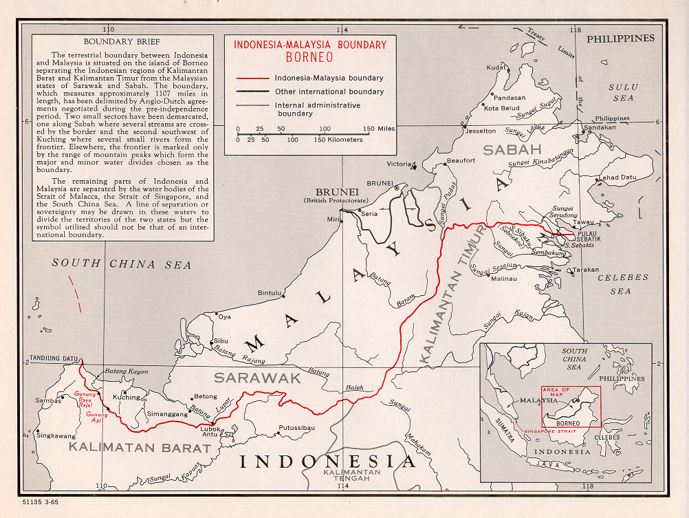
The land boundary stretches from Tanjung Datu at the northwestern corner of Borneo through the highlands of the Borneo hinterland to the Gulf of Sebatik and the Celebes Sea in the eastern side of the island. The boundary separates the Indonesian provinces of North Kalimantan, East Kalimantan and West Kalimantan from the Malaysian states of Sabah and Sarawak.
The maritime boundary in the Straits of Malacca generally follows the median line between the baselines of Indonesia and Malaysia, running south from the tripoint with Thailand to the start of the maritime border with Singapore. Only part of this boundary has been delimited through a continental shelf boundary treaty in 1969 and a territorial sea boundary treaty in 1970. The continental shelf boundary between Indonesia and Malaysia in the South China Sea is also drawn along the equidistant line between the baselines of the two countries under the 1969 continental shelf boundary.
The border in the Celebes Sea is disputed between the two countries. Part of the dispute was settled by the judgement of the International Court of Justice in the Ligitan and Sipadan Case in 2002 and is now awaiting delimitation between the two countries. However, the two countries still have overlapping claims over the continental shelf, which Indonesia refers to as Ambalat.
There are numerous sea transport crossings between Indonesia and Malaysia, mostly between Indonesia's Sumatra island and Peninsular Malaysia but also between the Indonesian province of North Kalimantan and Malaysia's Sabah state. There are only three official land transport crossing points, all between West Kalimantan and Sarawak. Both the land and maritime borders are relatively porous; many undocumented workers have crossed from Indonesia to Malaysia.
The territorial division of Borneo gained scant Dutch attention until the arrival of British soldier James Brooke in Sarawak in 1841, which the Dutch East Indies Government in Batavia (Jakarta) sensed as a threat to their hegemonic position over Bornean coastal trade. This drove the Dutch Governor General, J.J. Rochussen, to issue a decree in February 1846 outlining Dutch terrestrial interests (as opposed to mere coastal control) over Borneo. This document provided a fait-accompli division of Borneo based on the flow of watersheds. This decree was essentially the blueprint that the Dutch subsequently negotiated with the British that resulted in the Anglo-Dutch Treaty of 1891.
The principal document determining the land border between Indonesia and Malaysia on the island of Borneo is the Border Convention or London Convention of 1891 which was signed in London between the United Kingdom and the Netherlands, the two relevant colonial powers of that time, on 20 June 1891. Subsequent agreements between the colonial powers in 1915 and 1928 fine-tuned the border further. Much of the fine-tuning of the border concerned the Jagoi - Stass region in western Borneo, which, after negotiations stalled in 1930, was not yet considered definitive. The treaty and various agreements were subsequently adopted by Indonesia and Malaysia as successor states. The unresolved status of the maritime boundary in the Celebes Sea, which has been the source of recent Malaysia-Indonesia boundary disputes over Ligitan, Sipadan and Ambalat, is partly due to the fact that most maritime boundaries were never demarcated by the colonial powers, which focused primarily on land borders.
The convention states that the eastern end of the border would start at the 4° 10' North latitude, proceeding westward across the island of Sebatik off the coast of Sabah near Tawau town, bisecting it. The border then crosses the water channel between Sebatik and the mainland and travels up along the median line of the Tambu and Sikapal channels until the hills which form the watershed between the Simengaris (in Indonesia) and Serudung (in Malaysia) rivers. The border travels generally northwestward towards the 4° 20'N, and then generally westwards but accommodating the watershed, although the Pensiangan, Agisan and Sibuda rivers are allowed to intersect the border. The border then follows the line of ridges along the watershed between major rivers following northwards into the South China Sea, and those flowing eastwards, southwards and westwards into the Celebes Sea, Java Sea and Karimata Straits until Tanjung Datu at 109° 38'.8 E 02° 05'.0 N in the western extremity of Sarawak. The watershed is however not followed in a short stretch southwest of Kuching between Gunung Api at 110° 04'E and Gunung Raja at 109° 56'E where the border follows streams, paths, crests and straight lines which are marked by boundary markers and pillars.
Hub AI
Indonesia–Malaysia border AI simulator
(@Indonesia–Malaysia border_simulator)
Indonesia–Malaysia border
The Indonesia–Malaysia border consists of a 1,881 km (1,169 mi) land border that divides the territory of Indonesia and Malaysia on the island of Borneo. It also includes maritime boundaries along the length of the Straits of Malacca, in the South China Sea and in the Celebes Sea.
The land boundary stretches from Tanjung Datu at the northwestern corner of Borneo through the highlands of the Borneo hinterland to the Gulf of Sebatik and the Celebes Sea in the eastern side of the island. The boundary separates the Indonesian provinces of North Kalimantan, East Kalimantan and West Kalimantan from the Malaysian states of Sabah and Sarawak.
The maritime boundary in the Straits of Malacca generally follows the median line between the baselines of Indonesia and Malaysia, running south from the tripoint with Thailand to the start of the maritime border with Singapore. Only part of this boundary has been delimited through a continental shelf boundary treaty in 1969 and a territorial sea boundary treaty in 1970. The continental shelf boundary between Indonesia and Malaysia in the South China Sea is also drawn along the equidistant line between the baselines of the two countries under the 1969 continental shelf boundary.
The border in the Celebes Sea is disputed between the two countries. Part of the dispute was settled by the judgement of the International Court of Justice in the Ligitan and Sipadan Case in 2002 and is now awaiting delimitation between the two countries. However, the two countries still have overlapping claims over the continental shelf, which Indonesia refers to as Ambalat.
There are numerous sea transport crossings between Indonesia and Malaysia, mostly between Indonesia's Sumatra island and Peninsular Malaysia but also between the Indonesian province of North Kalimantan and Malaysia's Sabah state. There are only three official land transport crossing points, all between West Kalimantan and Sarawak. Both the land and maritime borders are relatively porous; many undocumented workers have crossed from Indonesia to Malaysia.
The territorial division of Borneo gained scant Dutch attention until the arrival of British soldier James Brooke in Sarawak in 1841, which the Dutch East Indies Government in Batavia (Jakarta) sensed as a threat to their hegemonic position over Bornean coastal trade. This drove the Dutch Governor General, J.J. Rochussen, to issue a decree in February 1846 outlining Dutch terrestrial interests (as opposed to mere coastal control) over Borneo. This document provided a fait-accompli division of Borneo based on the flow of watersheds. This decree was essentially the blueprint that the Dutch subsequently negotiated with the British that resulted in the Anglo-Dutch Treaty of 1891.
The principal document determining the land border between Indonesia and Malaysia on the island of Borneo is the Border Convention or London Convention of 1891 which was signed in London between the United Kingdom and the Netherlands, the two relevant colonial powers of that time, on 20 June 1891. Subsequent agreements between the colonial powers in 1915 and 1928 fine-tuned the border further. Much of the fine-tuning of the border concerned the Jagoi - Stass region in western Borneo, which, after negotiations stalled in 1930, was not yet considered definitive. The treaty and various agreements were subsequently adopted by Indonesia and Malaysia as successor states. The unresolved status of the maritime boundary in the Celebes Sea, which has been the source of recent Malaysia-Indonesia boundary disputes over Ligitan, Sipadan and Ambalat, is partly due to the fact that most maritime boundaries were never demarcated by the colonial powers, which focused primarily on land borders.
The convention states that the eastern end of the border would start at the 4° 10' North latitude, proceeding westward across the island of Sebatik off the coast of Sabah near Tawau town, bisecting it. The border then crosses the water channel between Sebatik and the mainland and travels up along the median line of the Tambu and Sikapal channels until the hills which form the watershed between the Simengaris (in Indonesia) and Serudung (in Malaysia) rivers. The border travels generally northwestward towards the 4° 20'N, and then generally westwards but accommodating the watershed, although the Pensiangan, Agisan and Sibuda rivers are allowed to intersect the border. The border then follows the line of ridges along the watershed between major rivers following northwards into the South China Sea, and those flowing eastwards, southwards and westwards into the Celebes Sea, Java Sea and Karimata Straits until Tanjung Datu at 109° 38'.8 E 02° 05'.0 N in the western extremity of Sarawak. The watershed is however not followed in a short stretch southwest of Kuching between Gunung Api at 110° 04'E and Gunung Raja at 109° 56'E where the border follows streams, paths, crests and straight lines which are marked by boundary markers and pillars.
Recent media