Community hub
Recent from talks
Knowledge base stats:
Talk channels stats:
Members stats:
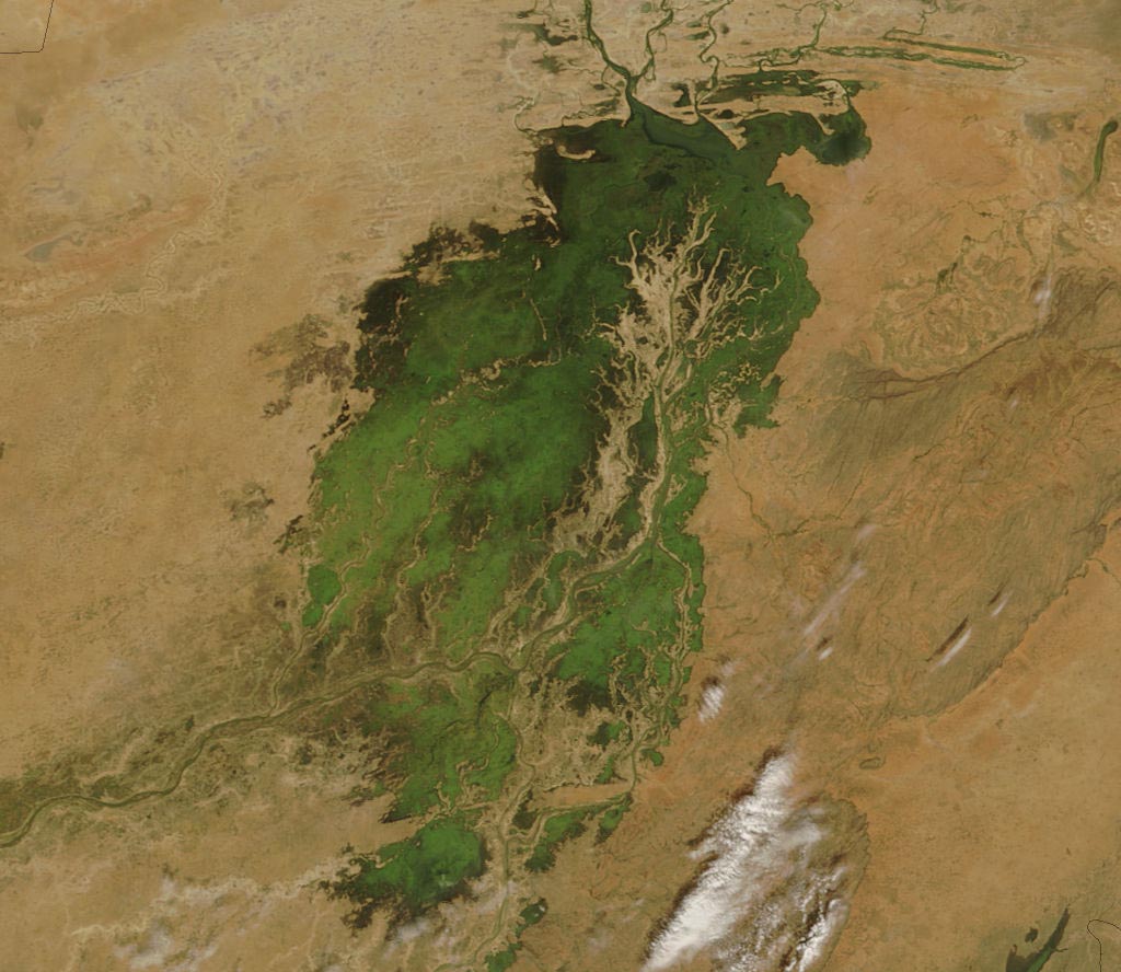
Inner Niger Delta
The Inner Niger Delta, also known as the Macina or Masina, is the inland river delta of the Niger River. It is an area of fluvial wetlands, lakes and floodplains in the semi-arid Sahel area of central Mali, just south of the Sahara Desert.
The delta consists of the middle course of the Niger River, between the bifurcated Niger and its tributary the Bani, which from here run north towards the desert. The Niger is the longest river in West Africa. Towns such as the river-port of Mopti, Sévaré and Djenné, with its mud-brick Great Mosque lie in the 400 km-long region.
The Fulani and Dogon inhabit the Macina region and the surrounding area, which has a population of over 500,000. Most of the year the area has a hot and dry climate, with hot winds from the nearby Sahara raising the temperature up to 40 °C or 104 °F. During the wet season, which generally lasts from June to September but is longer the further south one goes, the swamp floods into a lake and naturally irrigates the land. When the dry season comes, the Macina turns into a network of lakes and channels. Cattle, pearl millet, and rice are its important agricultural products. The Macina inland delta also provides water and fish for the Malians living there and during the wet season is a haven for large numbers of birds.
Due to its proximity to the widening Sahel, there have been concerns that the Macina may be getting less rain every year.
In the early 19th century, Seku Amadu founded a Massina Empire in the region, building a capital at Hamdullahi in 1820. The Massina fell to El Hadj Umar Tall's Toucouleur Empire in 1862, who in turn fell to the French army. The region became a part of the country of Mali on its independence in 1960.
The Niger inland Delta lies in the Sahelian zone, and has an ecosystem that is largely dependent on the amount of flooding it receives.
Precipitation in the water basins of the upper course of the Bani and Niger rivers makes for rising water levels downstream. The rising water floods varying parts of the low-level delta area, with the water rise determined by the amount of rain fallen upstream. This in turn, is influenced by the northward movement of the Intertropical Convergence Zone. A delay exists between the peak amount of precipitation and the maximum water level in the inland delta area. While the wet season lasts three months from July till September, the western and southern edges of the delta area are not flooded until early to mid-October. The consequence is that parts of the delta are flooded while the dry season is well under way. Note that only the lowest patches are flooded annually: higher elevations receive flooding in more intermittent periods due to the changing degrees of waterlevel rises. This division in roughly three zones (flooded, periodically flooded and not-periodically flooded), makes for patches that vary in their nature according to their proximity to a main body water and elevation.
In turn, this strongly affects land use in and around the inland delta, as human impact is driven by agriculture, both irrigated and rainfed, grazing and browsing of herds and flocks and the collection of wood for fuel, all dependent on the availability of water.
Hub AI
Inner Niger Delta AI simulator
(@Inner Niger Delta_simulator)
Inner Niger Delta
The Inner Niger Delta, also known as the Macina or Masina, is the inland river delta of the Niger River. It is an area of fluvial wetlands, lakes and floodplains in the semi-arid Sahel area of central Mali, just south of the Sahara Desert.
The delta consists of the middle course of the Niger River, between the bifurcated Niger and its tributary the Bani, which from here run north towards the desert. The Niger is the longest river in West Africa. Towns such as the river-port of Mopti, Sévaré and Djenné, with its mud-brick Great Mosque lie in the 400 km-long region.
The Fulani and Dogon inhabit the Macina region and the surrounding area, which has a population of over 500,000. Most of the year the area has a hot and dry climate, with hot winds from the nearby Sahara raising the temperature up to 40 °C or 104 °F. During the wet season, which generally lasts from June to September but is longer the further south one goes, the swamp floods into a lake and naturally irrigates the land. When the dry season comes, the Macina turns into a network of lakes and channels. Cattle, pearl millet, and rice are its important agricultural products. The Macina inland delta also provides water and fish for the Malians living there and during the wet season is a haven for large numbers of birds.
Due to its proximity to the widening Sahel, there have been concerns that the Macina may be getting less rain every year.
In the early 19th century, Seku Amadu founded a Massina Empire in the region, building a capital at Hamdullahi in 1820. The Massina fell to El Hadj Umar Tall's Toucouleur Empire in 1862, who in turn fell to the French army. The region became a part of the country of Mali on its independence in 1960.
The Niger inland Delta lies in the Sahelian zone, and has an ecosystem that is largely dependent on the amount of flooding it receives.
Precipitation in the water basins of the upper course of the Bani and Niger rivers makes for rising water levels downstream. The rising water floods varying parts of the low-level delta area, with the water rise determined by the amount of rain fallen upstream. This in turn, is influenced by the northward movement of the Intertropical Convergence Zone. A delay exists between the peak amount of precipitation and the maximum water level in the inland delta area. While the wet season lasts three months from July till September, the western and southern edges of the delta area are not flooded until early to mid-October. The consequence is that parts of the delta are flooded while the dry season is well under way. Note that only the lowest patches are flooded annually: higher elevations receive flooding in more intermittent periods due to the changing degrees of waterlevel rises. This division in roughly three zones (flooded, periodically flooded and not-periodically flooded), makes for patches that vary in their nature according to their proximity to a main body water and elevation.
In turn, this strongly affects land use in and around the inland delta, as human impact is driven by agriculture, both irrigated and rainfed, grazing and browsing of herds and flocks and the collection of wood for fuel, all dependent on the availability of water.