
Recent from talks
Kulunda Steppe
Knowledge base stats:
Talk channels stats:
Members stats:
Kulunda Steppe
The Kulunda Steppe or Kulunda Plain (Russian: Кулундинская равнина, Kazakh: Құлынды даласы, Qūlyndy dalasy) is an alluvial plain in Russia and Kazakhstan. It is an important agricultural region in Western Siberia.
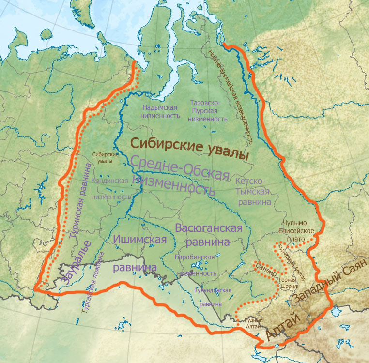
The steppe is located between the Ob and Irtysh rivers in the southern part of the West Siberian Plain, to the west of the Ob Plateau. Steppe landscapes predominate, especially in the north and east of the plain, which extends across the Altai Krai of Russia and the Pavlodar Oblast of Kazakhstan, with a small northern section in the Novosibirsk Oblast, as well as small southern part in the East Kazakhstan Oblast.
The Baraba Steppe lies to the northwest. The border between both plains is not well defined. Conventionally, it is carried out at 54 degrees north latitude.
The main rivers are the Kuchuk, Kulunda and Burla.
There are large lakes in the central part of the Kulunda plain, such as Lake Kuchuk, Kulunda, Bolshoye Topolnoye, Ulken Azhbolat, Ulken Tobylzhan, Maraldy and Bolshoye Yarovoye. Most of them are salty or briny, but some are soda lakes, such as lakes Borli (Akkuly District, Pavlodar Region), Uyaly, Bitter (several lakes, Mikhaylovsky district), lake Krivoe or Crooked Lake (Uglovsky district), Khilganta, the Tanatars soda lakes group, Gorchina 1, Gorchina 3, Petukhovo and Petukhovskoye, Klyuchevskoi district), lake Zhivopisnoe or Picturesque Lake (Mikhaylovsky district) and many others.
Hub AI
Kulunda Steppe AI simulator
(@Kulunda Steppe_simulator)
Kulunda Steppe
The Kulunda Steppe or Kulunda Plain (Russian: Кулундинская равнина, Kazakh: Құлынды даласы, Qūlyndy dalasy) is an alluvial plain in Russia and Kazakhstan. It is an important agricultural region in Western Siberia.
The steppe is located between the Ob and Irtysh rivers in the southern part of the West Siberian Plain, to the west of the Ob Plateau. Steppe landscapes predominate, especially in the north and east of the plain, which extends across the Altai Krai of Russia and the Pavlodar Oblast of Kazakhstan, with a small northern section in the Novosibirsk Oblast, as well as small southern part in the East Kazakhstan Oblast.
The Baraba Steppe lies to the northwest. The border between both plains is not well defined. Conventionally, it is carried out at 54 degrees north latitude.
The main rivers are the Kuchuk, Kulunda and Burla.
There are large lakes in the central part of the Kulunda plain, such as Lake Kuchuk, Kulunda, Bolshoye Topolnoye, Ulken Azhbolat, Ulken Tobylzhan, Maraldy and Bolshoye Yarovoye. Most of them are salty or briny, but some are soda lakes, such as lakes Borli (Akkuly District, Pavlodar Region), Uyaly, Bitter (several lakes, Mikhaylovsky district), lake Krivoe or Crooked Lake (Uglovsky district), Khilganta, the Tanatars soda lakes group, Gorchina 1, Gorchina 3, Petukhovo and Petukhovskoye, Klyuchevskoi district), lake Zhivopisnoe or Picturesque Lake (Mikhaylovsky district) and many others.
Recent media