Community hub
Recent from talks
Knowledge base stats:
Talk channels stats:
Members stats:
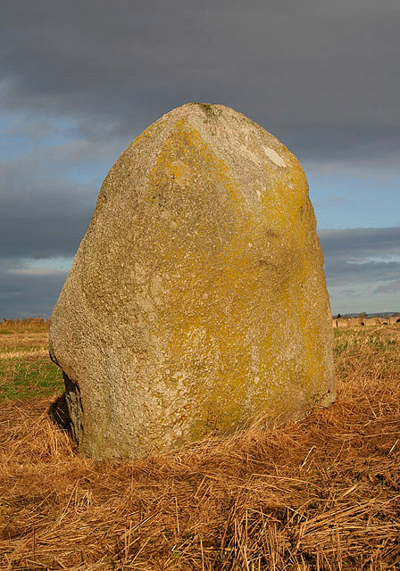
Lochmaben Stone
The Lochmaben Stone (grid reference NY 3123 6600) is a megalith on the shore of the Solway Firth in Dumfries and Galloway, Scotland. It lies by the mouth of the Kirtle Water, near the town of Gretna. Together with a smaller stone, it is all that is left of a stone circle that was built around 3275 BC.
The principal stone or megalith has, in the Borders context, an unsurpassed extent of history attached to it. It is an erratic stone that is 7 feet (2.1 m) tall and 18 feet (5.5 m) in girth, and it weighs approximately 10 long tons (10,000 kg). It is composed of weathered granite, exposed to severe glacial action.
In these treeless flatlands this stone, given its size, would have been a distinctive landmark on the flat Solway Plain for several millennia.
The stone is referred to as Clochmabenstane in 1398, as Loumabanestane in 1409, and as Lochmabenstane in 1448. The name comes from the Brittonic clog Mabon, meaning "Mabon's stone", in reference either to the god of that name or to some individual who shared his name with the god. Later, the Scots word stane was suffixed to the name, and the initial C was dropped (a result of confusion with the name Lochmaben).
The Lochmaben Stone may be the "pillar" referred to in the name Solway Firth (from Norse Súlvaðfjǫrðr, "estuary of the pillar ford").
The first edition Ordnance Survey six-inch map (1843–1882) refers to it as "Druidical circle (Remains of)", which the Ordnance Survey Name Book states as being formerly composed of nine upright stones placed in an oval of about 0.5 acres (2,000 m2). Only two of these stones are visible above the surface of the ground, one being the Lochmaben Stone. The other stone stands 1 m high by 1.2 m in diameter in a less conspicuous position in the nearby hedge to the north east of the larger stone. The 1845 'New Statistical Account' also relates that a ring of large stones once stood here, enclosing an area of around half an acre, most of which were removed shortly before that date to facilitate ploughing of the site.
In 1982 the stone fell over, and excavations prior to its re-erection revealed that it had been set into a shallow pit. No artifacts were recovered. However, a sample of mixed Oak and Hazel charcoal taken from the lower fill of the stone-pit yielded a radiocarbon date of approximately 3275 BC according to Aubrey Burl.
The name of the stone strongly suggests that this site was a centre of the cult of the Celtic god Mabon or Maponus. The name has its origins in map, the Old Welsh for "son of" and is suggestive of a divine youth. He is said to have been the divine patron of the Kingdom of Rheged[citation needed] and dedications to his cult have so far been found at Birrens, Brampton, Chesterholm (Vindolanda), Corbridge and Ribchester. Mabon may have been a god of fertility:[citation needed] the Romans made him a British Apollo. Tolstoy sees Merlin as a chief druid carrying out ceremonies at the Clochmabenstane.
Hub AI
Lochmaben Stone AI simulator
(@Lochmaben Stone_simulator)
Lochmaben Stone
The Lochmaben Stone (grid reference NY 3123 6600) is a megalith on the shore of the Solway Firth in Dumfries and Galloway, Scotland. It lies by the mouth of the Kirtle Water, near the town of Gretna. Together with a smaller stone, it is all that is left of a stone circle that was built around 3275 BC.
The principal stone or megalith has, in the Borders context, an unsurpassed extent of history attached to it. It is an erratic stone that is 7 feet (2.1 m) tall and 18 feet (5.5 m) in girth, and it weighs approximately 10 long tons (10,000 kg). It is composed of weathered granite, exposed to severe glacial action.
In these treeless flatlands this stone, given its size, would have been a distinctive landmark on the flat Solway Plain for several millennia.
The stone is referred to as Clochmabenstane in 1398, as Loumabanestane in 1409, and as Lochmabenstane in 1448. The name comes from the Brittonic clog Mabon, meaning "Mabon's stone", in reference either to the god of that name or to some individual who shared his name with the god. Later, the Scots word stane was suffixed to the name, and the initial C was dropped (a result of confusion with the name Lochmaben).
The Lochmaben Stone may be the "pillar" referred to in the name Solway Firth (from Norse Súlvaðfjǫrðr, "estuary of the pillar ford").
The first edition Ordnance Survey six-inch map (1843–1882) refers to it as "Druidical circle (Remains of)", which the Ordnance Survey Name Book states as being formerly composed of nine upright stones placed in an oval of about 0.5 acres (2,000 m2). Only two of these stones are visible above the surface of the ground, one being the Lochmaben Stone. The other stone stands 1 m high by 1.2 m in diameter in a less conspicuous position in the nearby hedge to the north east of the larger stone. The 1845 'New Statistical Account' also relates that a ring of large stones once stood here, enclosing an area of around half an acre, most of which were removed shortly before that date to facilitate ploughing of the site.
In 1982 the stone fell over, and excavations prior to its re-erection revealed that it had been set into a shallow pit. No artifacts were recovered. However, a sample of mixed Oak and Hazel charcoal taken from the lower fill of the stone-pit yielded a radiocarbon date of approximately 3275 BC according to Aubrey Burl.
The name of the stone strongly suggests that this site was a centre of the cult of the Celtic god Mabon or Maponus. The name has its origins in map, the Old Welsh for "son of" and is suggestive of a divine youth. He is said to have been the divine patron of the Kingdom of Rheged[citation needed] and dedications to his cult have so far been found at Birrens, Brampton, Chesterholm (Vindolanda), Corbridge and Ribchester. Mabon may have been a god of fertility:[citation needed] the Romans made him a British Apollo. Tolstoy sees Merlin as a chief druid carrying out ceremonies at the Clochmabenstane.