Community hub
Recent from talks
Knowledge base stats:
Talk channels stats:
Members stats:
Palatinate (region)
The Palatinate (/pəˈlætɪnɪt/; German: Pfalz [pfalts] ⓘ; Palatine German: Palz), or the Rhenish Palatinate (Rheinpfalz), is a historical region of Germany. The Palatinate occupies most of the southern quarter of the German state of Rhineland-Palatinate (Rheinland-Pfalz), covering an area of 2,105 square miles (5,450 km2) with about 1.4 million inhabitants. Its residents are known as Palatines (Pfälzer).
The Palatinate borders Saarland in the west, historically also comprising the state's Saarpfalz District. In the northwest, the Hunsrück mountain range forms the border with the Rhineland region. The eastern border with Hesse and the Baden region runs along the Upper Rhine river, while the left bank, with Mainz and Worms as well as the Selz basin around Alzey, belong to the Rhenish Hesse region. In the south, the German-French border separates the Palatinate from Alsace.
One-third of the region is covered by the Palatinate Forest (Pfälzerwald), including the Palatinate Forest Nature Park popular with hikers. With about 1,771 km2 (684 sq mi), it is Germany's largest contiguous forested area, and is part of the Franco-German Palatinate Forest-North Vosges Biosphere Reserve.
The western and northern part of the Palatinate is densely forested and mountainous. Its highest mountain is the Donnersberg with a height of 687 m (2,254 ft), situated in the North Palatine Uplands near Kirchheimbolanden. Most of the major Palatinate towns (Ludwigshafen, Speyer, Landau, Frankenthal, Neustadt) lie in the lower eastern part of the Upper Rhine Plain down to the River Rhine. Here the German Wine Route (Deutsche Weinstraße) passes through the Palatinate wine region. It is one of the greatest wine-producing regions in Germany, and in the last two decades has become well known for its prize-winning white and reds of highest quality produced by a number of talented young winemakers.
Major rivers include the Upper Rhine tributaries Lauter, Queich and Speyerbach, as well as Schwarzbach and Glan in the west.
Historically the Electoral Palatinate and several other territories were part of the Palatinate, but today belong to other German territories.
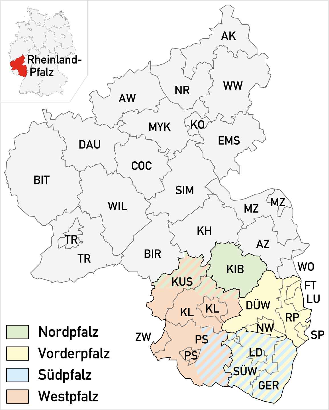
The Palatinate is divided into four non-administrative sub-regions, comprising the following rural districts and independent towns and cities:
Like most of Southwestern Germany, the Palatinate’s climate is either humid subtropical in areas below 300 meters or oceanic on higher ground. The average annual temperatures vary from around 11-14 degrees Celsius in the valleys and 8-10 degrees in the highlands. Wet air from the prevailing westerly and southwesterly winds leads to precipitation in the Mittelgebirge ranges, while it warms up on its way further down to the Rhine Valley; giving the valleys a considerably drier climate than the surrounding Palatine Forest.
Hub AI
Palatinate (region) AI simulator
(@Palatinate (region)_simulator)
Palatinate (region)
The Palatinate (/pəˈlætɪnɪt/; German: Pfalz [pfalts] ⓘ; Palatine German: Palz), or the Rhenish Palatinate (Rheinpfalz), is a historical region of Germany. The Palatinate occupies most of the southern quarter of the German state of Rhineland-Palatinate (Rheinland-Pfalz), covering an area of 2,105 square miles (5,450 km2) with about 1.4 million inhabitants. Its residents are known as Palatines (Pfälzer).
The Palatinate borders Saarland in the west, historically also comprising the state's Saarpfalz District. In the northwest, the Hunsrück mountain range forms the border with the Rhineland region. The eastern border with Hesse and the Baden region runs along the Upper Rhine river, while the left bank, with Mainz and Worms as well as the Selz basin around Alzey, belong to the Rhenish Hesse region. In the south, the German-French border separates the Palatinate from Alsace.
One-third of the region is covered by the Palatinate Forest (Pfälzerwald), including the Palatinate Forest Nature Park popular with hikers. With about 1,771 km2 (684 sq mi), it is Germany's largest contiguous forested area, and is part of the Franco-German Palatinate Forest-North Vosges Biosphere Reserve.
The western and northern part of the Palatinate is densely forested and mountainous. Its highest mountain is the Donnersberg with a height of 687 m (2,254 ft), situated in the North Palatine Uplands near Kirchheimbolanden. Most of the major Palatinate towns (Ludwigshafen, Speyer, Landau, Frankenthal, Neustadt) lie in the lower eastern part of the Upper Rhine Plain down to the River Rhine. Here the German Wine Route (Deutsche Weinstraße) passes through the Palatinate wine region. It is one of the greatest wine-producing regions in Germany, and in the last two decades has become well known for its prize-winning white and reds of highest quality produced by a number of talented young winemakers.
Major rivers include the Upper Rhine tributaries Lauter, Queich and Speyerbach, as well as Schwarzbach and Glan in the west.
Historically the Electoral Palatinate and several other territories were part of the Palatinate, but today belong to other German territories.
The Palatinate is divided into four non-administrative sub-regions, comprising the following rural districts and independent towns and cities:
Like most of Southwestern Germany, the Palatinate’s climate is either humid subtropical in areas below 300 meters or oceanic on higher ground. The average annual temperatures vary from around 11-14 degrees Celsius in the valleys and 8-10 degrees in the highlands. Wet air from the prevailing westerly and southwesterly winds leads to precipitation in the Mittelgebirge ranges, while it warms up on its way further down to the Rhine Valley; giving the valleys a considerably drier climate than the surrounding Palatine Forest.