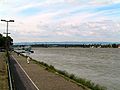
.jpg/250px-Oberrhein_bei_Iffezheim_(33932765658).jpg "Upper Rhine")
.jpg/2000px-Oberrhein_bei_Iffezheim_(33932765658).jpg)
Community hub
Recent from talks
Contribute something
Nothing was collected or created yet.
Upper Rhine
View on Wikipedia
| Upper Rhine (Oberrhein, Rhin Supérieur) | |
|---|---|
.jpg) Upper Rhine near Iffezheim | |
 Sections of the Rhine: Upper Rhine | |
| Location | |
| Country | Germany |
| States | Baden-Württemberg, Hesse, Rhineland-Palatine |
| Country | France |
| Region Departments | Grand-Est Bas-Rhin, Haut-Rhin |
| Country Canton | Switzerland Basel-Stadt |
| Physical characteristics | |
| Source | |
| • location | Rhine knee at Basel, Switzerland, continuation of the High Rhine |
| • coordinates | 47°33′37″N 7°35′23″E / 47.560148°N 7.589726°E |
| • elevation | 252 m |
| Mouth | |
• location | Bingen am Rhein, confluence with the Nahe, continues as Middle Rhine |
• coordinates | 49°58′11″N 7°53′21″E / 49.96972°N 7.88917°E |
• elevation | 89 m |
| Length | 360 km (220 mi) |
| Basin size | 185,000 km2 |
| Basin features | |
| Tributaries | |
| • left | Birsig, Ill, Lauter, Moder, Nahe |
| • right | Acher, Alb, Elz, Kander, Kinzig, Main, Murg, Neckar, Pfinz, Queich, Rench, Sauer, Selz, Wiese |
Upper Rhine (German: Oberrhein [ˈoːbɐˌʁaɪn] ⓘ; French: Rhin Supérieur is the section of the Rhine between the Middle Bridge in Basel, Switzerland, and the Rhine knee in Bingen, Germany. Representing kilometres 167 to 529 of the river[1][a] it is surrounded by the Upper Rhine Plain (Oberrheinische Tiefebene). Most of its upper section marks the France–Germany border.
The Upper Rhine is one of four sections of the river between Lake Constance and the North Sea, and is succeeded downstream by the Middle Rhine and Lower Rhine; only the High Rhine and Alpine Rhine lie above it. The countries and states along the Upper Rhine are Switzerland, France (Alsace) and the German states of Baden-Württemberg, Rhineland-Palatinate and Hesse. The largest cities along the river are Basel, Mulhouse, Strasbourg, Karlsruhe, Mannheim, Ludwigshafen and Mainz.
The Upper Rhine was straightened between 1817 and 1876 by Johann Gottfried Tulla and made navigable between 1928 and 1977. The Treaty of Versailles allows France to use the Upper Rhine for hydroelectricity in the Grand Canal d'Alsace.
On the left bank are the French region of Alsace and the German state of Rhineland-Palatinate; on the right bank are the German states of Baden-Württemberg and Hesse. The first few kilometres are in the Swiss city of Basel.
Geology
[edit]Around 35 million years ago, a rift valley of about 300 kilometres (190 mi) long and 50 kilometres (31 mi) wide came into being between the present cities of Basel and Frankfurt. This was due to tensile stresses in the Earth's crust and mantle, which resulted in lowering the earth's surface. The moat has been partially filled up again by sedimentation. On the edges we find mountain ridges, the so-called "rift flanks". On the eastern side, they are the Black Forest and Odenwald mountains, in the west the Vosges and Palatinate Forest. During the Tertiary, the High Rhine continued west from Basel and flowed via the Doubs and the Saône, into the Rhône. The rift diverted the Rhine into the newly formed Upper Rhine Valley.
The Rhine knee at Basel marks the transition from the High Rhine to the Upper Rhine with a change of direction from West to North and a change of landscape from the relatively small-chamber high-Rhine cuesta landscape to the wide rift zone of the Upper Rhine Rift Valley. The two largest tributaries come from the right: the Neckar in Mannheim, the Main across from Mainz. In the northwest corner of the Upper Rhine Valley, at Rhine-kilometre 529.1, near Bingen, where the Nahe flows into the Rhine, the Rhine flows into a gorge in the Rhenish Massif and thereby changes into the Middle Rhine.[3]
Geography
[edit]
Tributaries
[edit]Tributaries are listed in direction of flow (bottom to top), with the nearest settlement to their confluence given in brackets.
Left tributaties:
- Nahe (near Bingen am Rhein, Germany)
- Lauter (near Neuburg am Rhein)
- Moder (near Neuhäusel)
- Sauer (near Seltz)
- Ill (near Offendorf, France)
- Birsig (in Basel, Switzerland)
Right tributaries:
- Selz (in Ingelheim, Germany)
- Main (in Mainz)
- Neckar (in Mannheim)
- Queich (near Germersheim)
- Pfinz (near Germersheim)
- Murg (near Rastatt)
- Sauer (in Seltz, France)
- Acher (near Lichtenau)
- Rench (near Lichtenau)
- Kinzig (near Kehl)
- Elz (near Lahr)
- Kander (near Weil am Rhein)
- Wiese (near Basel, Switzerland)
Bordering regions
[edit]- Germany
- Switzerland
Tri-national metropolitan region
[edit]You can help expand this article with text translated from the corresponding article in German. (March 2012) Click [show] for important translation instructions.
|
You can help expand this article with text translated from the corresponding article in French. (March 2012) Click [show] for important translation instructions. Content in this edit is translated from the existing French Wikipedia article at [[:fr:Région métropolitaine trinationale du Rhin supérieur]]; see its history for attribution.{{Translated|fr|Région métropolitaine trinationale du Rhin supérieur}} to the talk page. |
The Upper Rhine tri-national region (French: Région Métropolitaine Trinationale du Rhin Supérieur, German: Trinationale Metropolregion Oberrhein) is a Euroregion that covers the border areas of the Upper Rhine (the northern part of the Upper Rhine valley and the Palatinate are not included as they are not border areas) and parts of the High Rhine. As the name suggests, it is a tri-national region comprising parts of France, Germany and Switzerland. The regional Upper Rhine Conference is a framework for future political and administrative cooperation in the area.
The tripoint between France, Germany and Switzerland, called Dreiländereck, lies within the uppermost portion of the Upper Rhine. A monument in Basel, known as the Pylon, is located 160 m (520 ft) southeast of the actual tripoint.
Interventions
[edit]Straightening
[edit].jpg)

In 1685, Louis XIV started a project to move the Upper Rhine, change its course and drain the floodplain, in order to gain land. By 1840, the river had been moved up to 1.5 kilometres (0.93 mi) to the east, taking territory away from Baden. Around 1790, large parts of the Rhine Valley were deforested, creating arable land, fields and pasture to feed the population. The Upper Rhine was straightened between 1817 and 1876 by Johann Gottfried Tulla and changed from a relatively sluggish meandering river with major and many smaller branches into a fast flowing stream flanked by embankments. The length of the Upper Rhine was reduced by 81 kilometres (50 mi). Some cut-off river arms and ox-bows remain; they are typically called the 'Old Rhine' (German: Altrhein) or Gießen (similar to the Old Rhine (Alter Rhein) in the Alpine Rhine Valley, where the Rhine was also straightened).
Canalising and dams
[edit]The Rhine between Basel and Iffezheim is almost entirely canalised. On a stretch of 180 kilometres (110 mi), there are 10 dams, provided with hydropower stations and locks. Between Basel and Breisach, the old river bed carries hardly any water; almost all water is diverted through the Grand Canal d'Alsace on the French side, to ensure safe shipping and hydropower generation around the clock. Only when there is a large supply of water, then the old river bed will receive more water than the canal. France gained the right to do this in the 1919 Treaty of Versailles; the right applies to the segment between Basel and Neuburgweier/Lauterbourg, where the Rhine forms the border between France and Germany.
The straightening (1817–76) and channeling (1928–77) reduced the water table by up to 16 metres (52 ft) and thus had a negative effect on flora and fauna. Gravel is also missing from the river, due to the dams. This has caused erosion below the dam at Iffezheim. To counter this, 173,000 cubic metres (6,100,000 cu ft) per year of a mixture of sand and gravel with an average grain diameter of 20 millimetres (0.79 in) (corresponding to the local sediment transport capacity) has been dumped into the river, since 1978, using two motorized barges.

Integrated Rhine Programme (IRP)
[edit]
The Upper Rhine plays a key role in flood control on the Middle and Lower Rhine. As a result of the straightening of the Upper Rhine, floods from the Alps now reach the Middle Rhine much faster than in the past. Thus, the risk of such a peak coinciding with a flood peak of Neckar, Moselle or Main has increased. About 123 square kilometres (47 sq mi) of floodplain have been lost. Authorities in riparian states of France, Baden-Württemberg and Rhineland-Palatinate have launched the Integrated Rhine Programme, a framework for designating water retention areas. to combat downstream flooding. A French-German treaty was concluded in 1982, in which the parties agreed to restore the retention capacity on the stretch below Iffezheim to the level it had before the area was developed.
This means: For the stretch between Iffezheim and the mouth of the Neckar, attenuation of the apex of a 200-year flood (i.e. a flood that statistically occurs once in 200 years) of the Rhine to a discharge of 5,000 cubic metres per second (180,000 cu ft/s) at the Maxau gauge station, that is, a reduction from 5,700 cubic metres per second (200,000 cu ft/s) to 5,000 cubic metres per second (180,000 cu ft/s).
- for the stretch below the mouth of the Neckar, attenuation of the apex of a 220-year flood to a discharge of 6,000 cubic metres per second (210,000 cu ft/s) at the Worms gauge station, that is, a reduction from 6,800 cubic metres per second (240,000 cu ft/s) to 6,000 cubic metres per second (210,000 cu ft/s).
For this purpose the following measures are planned and partially implemented:
- By France: Special operations power stations on the Rhine and construction of two polders Erstein and Moder
- By Baden-Württemberg: construction of about 13 polders
- By Rhineland-Palatinate: construction of polders and relocating levees
The effectiveness of the flood protection measures was verified using a computer model. The State Institute for the Environment, Nature Protection and Measurements in Baden-Württemberg carried out forecast calculations with the help of a mathematical "synoptic flood progression model". The analysis of the calculations and the evaluation of the results were made on the basis of the requirements and methods set by the international Flood Study Commission for the Rhine. The implementation of the proposed flood control measures on the Upper Rhine can prevent the occurrence of a 200-year-flood between Iffezheim and Bingen, with an overall economic loss estimated at around 6.2 billion euros.
Conservation
[edit]| Designations | |
|---|---|
| Official name | Oberrhein |
| Designated | 28 August 2008 |
| Reference no. | 1809[4] |
| Official name | Rhin Supérieur |
| Designated | 5 September 2008 |
| Reference no. | 1810[5] |
The floodplains between Mainz and Bingen are important for nature conservation. In this section, the so-called Island Rhine, there are many nature reserves and bird sanctuaries.
Gallery
[edit]-
 The Rhine at Mainz Theodor Heuss Bridge in Mainz
 -
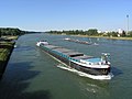 Cargo ships on the straightened Upper Rhine near Karlsruhe
 -
 Sunset on the Rhine at Mannheim
 -
 Fortifications on the Upper Rhine 1720


See also
[edit]Notes
[edit]- ^ The kilometrage of the Rhine begins at the Old Rhine Bridge in the city of Konstanz (Constance) and ends at the Hook of Holland at the North Sea.[2]
References
[edit]- ^ "Der Oberrhein [The Upper Rhine]" (in German). Retrieved 22 June 2024.
- ^ "Rheinkilometrierung [Rhine kilometrage]" (in German). Retrieved 22 June 2024.
- ^ "Hessian Ministry of Environment, Energy, Agriculture and Consumer Protection". Archived from the original on 29 October 2012. Retrieved 20 May 2011.
- ^ "Oberrhein / Rhin Supérieur". Ramsar Sites Information Service. Retrieved 25 April 2018.
- ^ "Rhin Supérieur / Oberrhein". Ramsar Sites Information Service. Retrieved 25 April 2018.
Bibliography
[edit]- Dieter Balle: Kultur- und Naturführer Oberrhein. Zwischen Mannheim und Basel, Verlag Regionalkultur, Ubstadt-Weiher 2007. ISBN 978-3-89735-496-8
- Manfred Bosch: Oberrheingeschichten, Verlag Klöpfer und Meyer, 2010, 384 pages, ISBN 3-940086-47-9 (an anthology)
- Upper Rhine Agency: Rahmenkonzept des Landes Baden-Württemberg zur Umsetzung des Integrierten Rheinprogramms. Part I Wiederherstellung des Hochwasserschutzes, Part II Erhaltung und Renaturierung der Auelandschaft am Oberrhein. Materialien zum integrierten Rheinprogramm. Lahr, September, 1996
- Ministry of Environment Baden-Württemberg: Das Integrierte Rheinprogramm: Hochwasserschutz und Auenrenaturierung am Oberrhein, Stuttgart, May, 2007
- Water and Shipping Directorate South West: Kompendium der Wasser- und Schifffahrtsdirektion Südwest. Organizational and technical data, inland navigation, duties, waterways. Self-published, June 2007
External links
[edit]- Official tourism website of the Upper Rhine Valley
- EUCOR-URGENT
- Franco-German-Swiss Conference of the Upper Rhine
- Regional Association of the Southern Upper Rhine
- RegionalverRegional Association of the Central Upper Rhine
- Association for Regional History in the Upper Rhine area
- Information on the Integrated Rhine Programme from the government office in Freiburg
- Water Management Administration of Rhineland-Palatinate
- Gauge station Maxau
- The floodplain north of Strasbourg
48°57′N 8°16′E / 48.950°N 8.267°E
| International | |
|---|---|
| National | |
Upper Rhine
View on GrokipediaThe Upper Rhine constitutes the river section spanning from Basel, Switzerland, to Bingen am Rhein, Germany, measuring approximately 360 kilometers in length and traversing the tectonically active Upper Rhine Graben, a continental rift valley characterized by extensional faulting and subsidence.[1][2][3] This segment originates downstream of the High Rhine at the Basel central bridge and flows northward through a broad alluvial plain, initially forming the border between France and Germany for roughly 184 kilometers before entering German territory exclusively near Lauterbourg.[4] The graben's geological structure, extending over 300 kilometers with an average width of 50 kilometers, results from Miocene to recent rifting, influencing the river's meandering path and sediment deposition patterns.[3] Extensively modified through 19th- and 20th-century engineering projects, including channel straightening initiated by Johann Gottfried Tulla and the installation of ten barrages for canalization, the Upper Rhine supports heavy commercial navigation while enhancing flood protection, though these interventions have reduced floodplain dynamics and biodiversity.[5][6] As a critical European waterway, it facilitates the transport of bulk goods such as coal, ores, and containers, underpinning industrial clusters in regions like Alsace, Baden-Württemberg, and Rhineland-Palatinate, with disruptions like low water levels demonstrating its outsized economic influence.[7][8] The area's strategic location has historically shaped fortifications and conflicts, while modern efforts focus on ecological restoration amid ongoing tectonic and climatic pressures.[9]
Geological and Physical Characteristics
Rift Valley Formation
![Satellite image of the Upper Rhine Graben from NASA][float-right] The Upper Rhine Graben, constituting the structural trough traversed by the Upper Rhine River, represents a key segment of the European Cenozoic Rift System, extending approximately 300 kilometers in length and averaging 50 kilometers in width from the Swiss Jura to the Hessian depression.[10] Its formation initiated during the Late Eocene around 40 million years ago, driven by extensional tectonics linked to the distant effects of Alpine collisional compression, which induced crustal stretching and faulting in the foreland.[11] Preexisting crustal weaknesses, inherited from the Variscan orogeny in the Paleozoic era (approximately 380-300 million years ago), particularly northeast-trending fault zones in the basement, exerted primary control on the graben's localization and asymmetry, facilitating reactivation under changing stress regimes.[11] The primary rifting phase unfolded during the Oligocene (33-23 million years ago), characterized by significant normal faulting along border faults such as the eastern Upper Rhine fault zone, leading to subsidence rates exceeding 100 meters per million years in depocenters and accumulation of up to 3-4 kilometers of syn-rift sediments including lacustrine, fluvial, and minor marine deposits.[11] Extension persisted into the Miocene (23-5 million years ago) with a shift toward transtension in some segments, influenced by ongoing Alpine indentation and possible asthenospheric upwelling, though volcanic activity remained subdued compared to other rift arms, limited to alkali basalts and trachytes dated to around 68 million years ago in northern exposures but primarily post-dating main rifting.[12] This evolution reflects a polyphase process where initial Eocene-Oligocene pure extension transitioned to Miocene oblique rifting, constrained by thermomechanical models indicating brittle-ductile crustal deformation under NE-SW directed extension.[13] Post-Miocene development involved reduced extension rates, with Plio-Quaternary depocenters signaling renewed tectonic activity along reactivated faults, evidenced by seismic reflection data revealing two major asymmetric rift units and ongoing subsidence filled by Quaternary alluvial sediments up to 200 meters thick.[14] The graben remains tectonically active, as demonstrated by historical seismicity including the 1356 Basel earthquake of magnitude ~6.5, originating from faults within the southern Upper Rhine Graben, underscoring persistent intraplate deformation amid stable European cratonic conditions.[15] Overall, the rift's failed nature—lacking oceanic spreading—stems from insufficient extension magnitudes, estimated at 10-20% beta factors, ultimately arrested by isostatic and collisional feedbacks from the evolving Alpine belt.[11]Hydrological Features
The Upper Rhine, spanning approximately 350 km from Basel to Mainz, features a hydrological regime shaped by alpine influences upstream and increasing pluvial dominance downstream, with mean annual discharges rising from 1059 m³/s at Basel to 1588 m³/s near Mainz due to tributary inflows such as the Aare and Neckar.[16] [17] The river's longitudinal profile exhibits a low average bed slope of about 0.05% (0.5 m/km), facilitating historical sediment deposition and meandering but also contributing to flood risks during high-flow events.[18] Seasonal variations show a traditional nivo-pluvial pattern, with peaks from snowmelt and winter rains, though 20th-century trends indicate rising winter runoff and stable or declining summer flows, reducing overall seasonality due to glacier retreat, altered precipitation, and upstream reservoir regulation.[19] Suspended sediment transport in the Upper Rhine is characterized by downstream increases in silt and clay loads from tributaries, while sand transport varies with channel morphology; historical rates have been curtailed by engineering interventions, leading to net deposition in impounded reaches and erosion elsewhere.[20] [21] The basin's water balance reflects higher precipitation in upstream alpine areas (contributing to runoff coefficients of 0.4–0.6) versus lower evapotranspiration demands in the rift valley, where annual precipitation averages 700–900 mm, supporting the river's role as a conduit for transboundary water resources.[22] Extreme events underscore hydrological variability, with recorded peak discharges exceeding 10,000 m³/s during major floods, such as those in 1926, driven by synchronized rainfall and melt across the catchment.[23] ![Rhein-Karte2.png][center]Tributaries and Channel Morphology
The Upper Rhine receives notable tributaries from both banks along its course from Basel to Bingen, contributing to its hydrological regime within the Upper Rhine Graben. The most significant left-bank tributary is the Ill River, which spans approximately 220 km and drains a catchment area of 4,760.5 km² through the Alsace region before joining the Rhine at kilometer 311.3 near Strasbourg, downstream of the Gambsheim barrage.[1] On the right bank, inflows from the Black Forest include the Elz, Kinzig, and Murg rivers, which add discharge from forested uplands and support local sediment transport into the main channel.[1] These tributaries, influenced by Alpine meltwater cycles, peak in volume during early summer, enhancing the Rhine's overall flow variability.[1] In its geological context, the Upper Rhine's channel morphology reflects the rift valley setting of the Upper Rhine Graben, featuring a low-gradient, gravel-bed river system with historically dynamic planform adjustments. Prior to 19th-century engineering interventions, the channel displayed a complex braided-anabranching pattern, characterized by multiple interwoven threads, extensive gravel and sand bars, and lateral migration across a broad floodplain up to several kilometers wide.[5] This configuration arose from high sediment loads delivered during Late Glacial and Holocene phases, with paleochannel networks evidencing repeated avulsions and infilling in the French Upper Rhine alluvial plain.[24] Downstream variations included sectorized patterns, where upper reaches showed more stable braiding while lower segments exhibited meandering tendencies modulated by subsidence and sediment supply.[25] Bed material primarily consists of coarse gravel, facilitating riffle-pool sequences and bar formation under natural flows exceeding 1,000 m³/s during floods.[26]Historical Human Interactions
Ancient and Medieval Utilization
The Upper Rhine, stretching from Basel to approximately Bingen, functioned primarily as a military frontier and nascent trade artery during antiquity. Julius Caesar encountered the river in 58 BCE during campaigns against the Helvetii tribe, designating it as the eastern boundary of Roman Gaul and initiating Roman military presence in the region.[27] Roman engineering emphasized defensive infrastructure, including legionary fortresses such as Moguntiacum (modern Mainz), established around 13 BCE as a base for Legio XIV Gemina, and Argentoratum (Strasbourg), founded circa 12 BCE to secure the frontier against Germanic incursions.[28] The river facilitated limited navigation for troop movements and commerce, transporting goods like grain, wine, and metals from Gaul into Roman provinces, though rapids and seasonal floods constrained upstream travel to shallow-draft vessels. By the late 3rd century CE, pressures from Germanic migrations prompted partial abandonment of forward defenses, with Emperor Valentinian I reinforcing the Rhine line around 370 CE through extended fortifications and fleet bases.[29][28] In the medieval period, the Upper Rhine transitioned into a vital commercial waterway and settlement hub under Frankish and Holy Roman Empire oversight, supporting trade in salt, timber, and agricultural produce from the fertile graben valley. Early medieval sites, including continuations of Roman-era nuclei at Basel and Strasbourg, evidenced persistent occupation and economic activity, with archaeological data indicating land-use patterns focused on floodplain agriculture and riverine exchange from the 5th century onward.[30] By the 10th-12th centuries, burgeoning urban centers like Speyer (founded as a bishopric in 1077) and Worms leveraged the river for inter-regional commerce, integrating with overland routes to the Alps and North Sea. Navigation relied on oar- and sail-powered barges, though tolls—such as those documented in the mid-13th century upstream of Mainz—imposed economic controls, with at least several stations extracting fees on cargoes averaging 8 denari per vessel in the 1240s.[31] Monastic foundations, including those near Strasbourg, further utilized the waterway for provisioning, underscoring the Rhine's role in sustaining feudal economies amid recurrent floods that necessitated adaptive embankment practices by the 11th century.[32]Pre-Modern Flood Patterns and Settlement
The Upper Rhine's pre-modern hydrological regime featured a dynamic, braided river system prone to frequent flooding due to high sediment loads from Alpine tributaries, combined with snowmelt and persistent rainfall. Documentary and proxy records reveal major flood events dating to at least the 13th century, including destructive inundations at Basel in 1342, 1544, and 1682, which hydraulic modeling estimates reached discharges exceeding 5,000 cubic meters per second—far surpassing modern regulated flows.[33] In the southern Upper Rhine, chronicles document clusters such as the July 1480 event affecting multiple tributaries and the December 1506 flood, with over 20 notable occurrences in the 15th century alone on the French (Alsace) side, driven primarily by rain-on-snow mechanisms under westerly atmospheric patterns.[34] Summer floods peaked in frequency during 1651–1750, correlating with elevated regional precipitation, while winter events dominated overall, reflecting the river's sensitivity to seasonal Alpine discharge variability.[33] These floods caused extensive damage, including erosion of banks, deposition of coarse sediments, and prolonged inundation of lowlands, often lasting weeks and leading to livestock drownings, bridge collapses, and crop failures across the valley floor. Impacts were spatially variable: Rhine-mainstem floods isolated settlements, while tributary-synced events amplified backwater effects in confluences like those of the Ill or Kinzig rivers. Geoarchaeological evidence from sites like the Gallo-Roman town of Oedenburg near Rheinau indicates repeated overbank flooding from the 1st to 4th centuries AD, burying structures under meters of silt and constraining urban expansion to slightly elevated alluvial fans.[35] Pre-19th-century frequency estimates suggest decadal-scale major events, with minor floods annually in wet periods, exacerbating soil salinization and channel avulsions that reshaped the floodplain morphology.[34] Settlement strategies adapted causally to this hazard-prone environment, prioritizing geomorphically stable locations to minimize exposure. Neolithic and Bronze Age communities favored loess-covered terrace edges above the rift valley floor for defensibility and drainage, as evidenced by archaeological distributions avoiding active floodplains, where fertility from silt deposits was offset by recurrent destruction.[36] By the medieval period, this evolved into clustered villages on higher rims—such as those along the Black Forest and Vosges escarpments—while lowlands served for transient pastoralism or forestry, with permanent habitation limited to natural levees or islands like the Maîche near Strasbourg. Early diking efforts, traceable to the 11th century via radiocarbon-dated organic layers beneath embankments, enabled piecemeal reclamation on the German (Baden) bank, promoting arable expansion and denser rural patterns despite breaches during peaks like 1524.[37] In contrast, Alsatian territories enforced communal restraint on floodplain intrusion through legal bans on private dikes until the 16th century, preserving wetlands as buffers and curtailing settlement vulnerability compared to the engineered German side.[34][38] This divergence highlights how local governance and technical capacity mediated flood risks, with dike proliferation inadvertently heightening exposure to extreme events by confining flows into narrower channels.19th-Century Engineering Transformations
The primary 19th-century engineering transformation of the Upper Rhine involved the systematic rectification initiated by Johann Gottfried Tulla, a Badenese hydraulic engineer, to address chronic flooding and improve navigation along the meandering river course from Basel to Mannheim. Tulla's plans, outlined in detailed proposals such as his 1822 memorandum on the Rhine's regulation, advocated for cutting off oxbows and meanders through artificial channels while reinforcing banks with dikes and revetments to confine the flow.[39] [40] Construction began in 1817 under Tulla's direction, marking the start of large-scale interventions that shifted the river from its natural, braided morphology to a more linear and controlled waterway.[41] Key early works included the diversion near Ketsch in 1833, where engineers excavated a cutoff channel to bypass a pronounced loop, shortening the local path and accelerating flow to prevent sediment deposition and overflow.[42] These measures were extended progressively through the mid-century, with Baden and other states coordinating efforts to build parallel flood embankments and stabilize the thalweg, reducing the river's historical tendency to shift laterally during high discharges. By the late 19th century, the Upper Rhine had been modified into a regularly flowing, straight, and revetted course, substantially lowering flood peaks in the valley and enabling expanded settlement on reclaimed floodplains.[43] [44] The rectification's causal effects stemmed from increased channel gradient and velocity post-straightening, which minimized meander reformation and enhanced sediment transport downstream, though it also lowered regional groundwater levels and altered local ecosystems by confining dynamic braiding processes.[6] Empirical observations from the period, including reduced inundation frequency in agricultural areas, validated the flood mitigation goals, as documented in state engineering reports, despite initial resistance from riparian communities concerned over disrupted fisheries and water access.[44] Works continued until around 1880, establishing a foundational framework for subsequent 20th-century modifications while prioritizing utilitarian outcomes over unaltered natural variability.[41]Modern Infrastructure and Modifications
Canalization and Barrage Systems
The canalization of the Upper Rhine transformed its braided, meandering course into a straightened, revetted channel primarily during the 19th century to mitigate recurrent flooding and enhance navigability. Engineering efforts reduced the river's length by confining it within dikes and eliminating loops, resulting in a more uniform flow regime that accelerated discharge and minimized overflow onto adjacent floodplains.[43] This phase, spanning from the early 1800s, involved systematic removal of side arms and islands, altering the natural morphology to prioritize human control over hydrological variability.[6] In the 20th century, barrage systems supplemented initial canalization by introducing run-of-river dams equipped with locks and hydropower turbines, enabling consistent navigation depths amid seasonal low flows. The Grand Canal d'Alsace, developed parallel to the Rhine from Basel to Breisach starting in 1932 and operational by 1959, bypassed shallow rapids and incorporated multiple hydroelectric stations to harness the river's gradient while providing a controlled waterway for barge traffic.[41] Downstream, German authorities constructed ten barrages between Rheinau and Iffezheim from the 1960s to 1977, each featuring ship lifts or locks to accommodate vessels up to 1,400 tons and maintain a minimum channel depth of 2.5–3 meters during droughts.[45] These structures regulate water levels upstream, storing excess during high flows for controlled release, thereby balancing flood retention with uninterrupted commercial transport.[46] The integrated barrage network, totaling over 300 kilometers of modified waterway, supports year-round navigation for push convoys while generating approximately 3,000 megawatts of electricity across facilities like those at Iffezheim, which alone produces 900 megawatts with an annual output exceeding 3.5 billion kilowatt-hours.[5] Operational protocols prioritize minimum ecological flows in bypassed old riverbeds to sustain residual habitats, though retention volumes are capped to avoid exacerbating downstream scour.[44] This engineering paradigm reflects a causal prioritization of economic utility—facilitating 200 million tons of annual freight—over unaltered floodplain dynamics, with barrages demonstrably reducing low-water interruptions from historical norms of several months to near-elimination.[43]Navigation Infrastructure
The navigation infrastructure of the Upper Rhine, spanning from Basel to Iffezheim, features a canalized channel with ten barrages equipped with locks to maintain sufficient water depth and ensure year-round accessibility for commercial vessels despite the river's natural gradient.[47] This system, developed primarily between the 1930s and 1970s, includes the Grand Canal d'Alsace for the initial stretch from Basel to approximately Breisach, followed by direct river canalization.[4] The locks accommodate large inland vessels, including self-propelled barges up to 185 meters in length and 11.4 meters in beam, as well as pushed convoys comprising multiple units for enhanced cargo capacity.[48] Key installations include the twin locks at Kembs, operational since the 1930s with dimensions of 182.5 by 25 meters and a smaller 100 by 25 meters, alongside subsequent locks at sites such as Vogelgrün, Fessenheim, Marckolsheim, Gambsheim, Strasbourg, Rhinau, Gerstheim, and culminating at Iffezheim.[4] These facilities regulate water levels to support a minimum depth of about 2.5 to 3 meters, critical for the transport of bulk goods like chemicals, aggregates, and containers originating from major ports including Basel, Strasbourg, Karlsruhe, and Mannheim.[48] The infrastructure adheres to standards set by the Central Commission for the Navigation of the Rhine (CCNR), which oversees uniform regulations for vessel traffic and safety along the waterway.[48] Annual freight traffic on the Upper Rhine segment contributes substantially to the overall Rhine corridor's volume, with container throughput reaching 0.67 million TEU in 2018, reflecting its role in European inland logistics despite occasional disruptions from low water levels or maintenance.[49] The fleet includes approximately 6,900 vessels with a collective capacity exceeding 10 million tonnes, predominantly motor cargo ships, tankers, and pushed barges optimized for the channel's constraints.[48] Modernization efforts, such as lock expansions, continue to address bottlenecks and accommodate growing push convoy operations, which can exceed 10,000 tonnes per passage.[47]Hydropower Installations
The hydropower installations on the Upper Rhine primarily comprise run-of-the-river power plants integrated with the barrages erected during the river's canalization from the 1930s to the 1970s, aimed at improving navigation, flood control, and energy production. Spanning approximately 160 kilometers from near Basel (Rhine kilometer 170) to Iffezheim (Rhine kilometer 334), these ten facilities—eight operated by Électricité de France (EDF) along the Grand Canal d'Alsace and two further downstream under joint German-French management—harness the Rhine's steady flow to generate renewable electricity without large-scale reservoirs. Collectively, they produce around 9 billion kilowatt-hours annually, equivalent to the consumption of over 2.5 million households, underscoring their role in regional energy supply.[50] The Grand Canal d'Alsace, constructed between 1932 and 1959 parallel to the Rhine border, diverts water through eight barrages equipped with turbines: Kembs (commissioned 1935, capacity approximately 60 MW), Ottmarsheim (1940s, 125 MW), Fessenheim (1950s, 180 MW), Vogelgrün (1959, 140 MW), and smaller stations at Marckolsheim, Rhinau, Gerstheim, and Strasbourg. These EDF-managed plants total an installed capacity exceeding 600 MW, yielding about 3,760 gigawatt-hours per year from the canal's controlled flow.[51][52] Downstream, the Gambsheim barrage (Rhine kilometer 332, completed 1975) and Iffezheim barrage (1978) extend the system into German territory, with joint operation by EnBW and EDF. Iffezheim, the largest installation, features five Kaplan turbines with a total capacity of 148 MW following a 2013 modernization that added a 38 MW unit, enabling output of roughly 860 gigawatt-hours annually under average conditions.[53][54][55] These plants utilize bulb or Kaplan turbines optimized for low-head, high-flow conditions typical of the straightened Rhine, with fish passes and sediment management features incorporated to mitigate ecological disruption.[56]| Barrage | Approximate Capacity (MW) | Commissioning Year | Operator |
|---|---|---|---|
| Kembs | 60 | 1935 | EDF |
| Ottmarsheim | 125 | 1947 | EDF |
| Fessenheim | 180 | 1957 | EDF |
| Vogelgrün | 140 | 1959 | EDF |
| Iffezheim | 148 | 1978 (expanded 2013) | EnBW/EDF |