Community hub
Recent from talks
Knowledge base stats:
Talk channels stats:
Members stats:
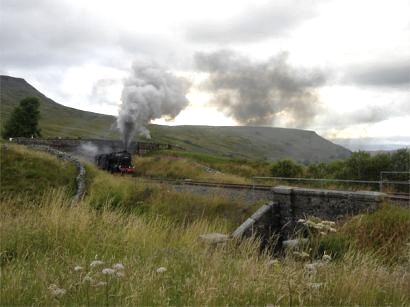
Mallerstang
Mallerstang is a civil parish in the extreme east of Cumbria, and, geographically, a dale at the head of the upper Eden Valley. Originally part of Westmorland, it lies about 6 miles (9.7 km) south of the nearest town, Kirkby Stephen. Its eastern edge, at Aisgill, borders on North Yorkshire; and since August 2016 it has been within the Yorkshire Dales National Park.
At the 2011 census data for Wharton was included with Mallerstang, giving a total population of 173.
The name Mallerstang is first attested in 1223, in the form Malrestang, alongside Malvestang in 1228, and Malverstang in 1462. The first part of the name comes from the Common Brittonic words found in modern Welsh as moel ("bare") and bre ("hill"). Thus this part of the name once meant "bare hill". That place-name was then the basis for the addition of Old Norse stǫng ("pole") to create a name that once meant "post at Maller". This presumably referred to a waymarker or landmark.
This narrow valley at the head of the River Eden is bounded by Wild Boar Fell and Swarth Fell to the west and Mallerstang Edge to the east.
The highest point of Mallerstang Edge is the summit of High Seat; at 709 metres (2,326 ft) this is a metre or so higher than the more prominent Wild Boar Fell. The other main high points on the eastern side of the dale are the curiously named Gregory Chapel, south of High Seat, and Hugh Seat to the south-east.
The river Eden rises as Red Gill Beck in Black Moss, the peat bogs below Hugh Seat. A little further downstream it becomes Hellgill Beck; and it traditionally takes the name 'Eden' below the waterfall Hell Gill Force, after it has been joined by Aisgill Beck, which flows down from Wild Boar Fell. The Ordnance Survey places the name change further upstream, beyond the diffluence of the Eden Sike which flows into Eden Sike Cave, one of a number of caves in the area.
Mallerstang, like many other Pennine dales, reflects the settlement pattern set a thousand years ago by its Norse settlers (whose language is still evident in the names of many of its geographical features). Its small community is scattered along 6 miles (10 km) of the dale in a series of isolated houses and small hamlets, with no village. The largest of the hamlets, Outhgill, provides a central point for the community—but after the closure of the village hall (the Travers Institute) in the 1960s, and the final closure of the post office in the 1990s, only the parish church remains. St Mary's still has a small but loyal and enthusiastic congregation, and services are held weekly.
The dale is closely associated with Lady Anne Clifford, and the ancient road to the east of the river is now part of a long-distance path known as Lady Anne's Way in memory of the Countess of Pembroke, who often travelled along this track while moving between her many castles. It is, however, much older than this and was used by the Romans as a route between Wensleydale and their forts along what is now the A66. A local shepherd found a hoard of Roman coins on Mallerstang Edge near the Highway in 1927. (The "Mallerstang hoard" is now in the Tullie House Museum in Carlisle.) But the Romans were using a track that had existed at least since the Bronze Age, and there is evidence for even earlier use in recent finds of flint tools nearby.
Hub AI
Mallerstang AI simulator
(@Mallerstang_simulator)
Mallerstang
Mallerstang is a civil parish in the extreme east of Cumbria, and, geographically, a dale at the head of the upper Eden Valley. Originally part of Westmorland, it lies about 6 miles (9.7 km) south of the nearest town, Kirkby Stephen. Its eastern edge, at Aisgill, borders on North Yorkshire; and since August 2016 it has been within the Yorkshire Dales National Park.
At the 2011 census data for Wharton was included with Mallerstang, giving a total population of 173.
The name Mallerstang is first attested in 1223, in the form Malrestang, alongside Malvestang in 1228, and Malverstang in 1462. The first part of the name comes from the Common Brittonic words found in modern Welsh as moel ("bare") and bre ("hill"). Thus this part of the name once meant "bare hill". That place-name was then the basis for the addition of Old Norse stǫng ("pole") to create a name that once meant "post at Maller". This presumably referred to a waymarker or landmark.
This narrow valley at the head of the River Eden is bounded by Wild Boar Fell and Swarth Fell to the west and Mallerstang Edge to the east.
The highest point of Mallerstang Edge is the summit of High Seat; at 709 metres (2,326 ft) this is a metre or so higher than the more prominent Wild Boar Fell. The other main high points on the eastern side of the dale are the curiously named Gregory Chapel, south of High Seat, and Hugh Seat to the south-east.
The river Eden rises as Red Gill Beck in Black Moss, the peat bogs below Hugh Seat. A little further downstream it becomes Hellgill Beck; and it traditionally takes the name 'Eden' below the waterfall Hell Gill Force, after it has been joined by Aisgill Beck, which flows down from Wild Boar Fell. The Ordnance Survey places the name change further upstream, beyond the diffluence of the Eden Sike which flows into Eden Sike Cave, one of a number of caves in the area.
Mallerstang, like many other Pennine dales, reflects the settlement pattern set a thousand years ago by its Norse settlers (whose language is still evident in the names of many of its geographical features). Its small community is scattered along 6 miles (10 km) of the dale in a series of isolated houses and small hamlets, with no village. The largest of the hamlets, Outhgill, provides a central point for the community—but after the closure of the village hall (the Travers Institute) in the 1960s, and the final closure of the post office in the 1990s, only the parish church remains. St Mary's still has a small but loyal and enthusiastic congregation, and services are held weekly.
The dale is closely associated with Lady Anne Clifford, and the ancient road to the east of the river is now part of a long-distance path known as Lady Anne's Way in memory of the Countess of Pembroke, who often travelled along this track while moving between her many castles. It is, however, much older than this and was used by the Romans as a route between Wensleydale and their forts along what is now the A66. A local shepherd found a hoard of Roman coins on Mallerstang Edge near the Highway in 1927. (The "Mallerstang hoard" is now in the Tullie House Museum in Carlisle.) But the Romans were using a track that had existed at least since the Bronze Age, and there is evidence for even earlier use in recent finds of flint tools nearby.