

Community hub
Recent from talks
Contribute something
Nothing was collected or created yet.
Kirkby Stephen
View on Wikipedia
Kirkby Stephen (/ˈkɜːrbi/) is a market town and civil parish in Cumbria, England. It lies on the A685 and is surrounded by sparsely populated hill country, about 25 miles (40 km) from the nearest larger towns, Kendal and Penrith. The River Eden rises 6 miles (10 km) away in the peat bogs below Hugh Seat and passes the eastern edge of the town. At the 2001 census the parish had a population of 1,832.[2][1] In 2011, it had a population of 1,822.[3]
Key Information


The name Kirkby derives from the Old Norse kirkju-býr meaning 'village with a church'. The Stephen part of the name is thought to derive from either the church (which may have previously been dedicated to St Stephen) or from a medieval abbot called Stephen.[4]
Market
[edit]In 1352–1353, Roger de Clifford, Baron of Westmorland, obtained a charter from King Edward III for a market and two annual fairs to be held in the town. This was reaffirmed by a charter granted in 1605 to George, Earl of Cumberland, by King James I, for "one market on Monday and two fairs yearly; one on the Wednesday, Thursday and Friday after Whitsuntide and the other on the two days next before the feast of St Luke."
The Monday market, with livestock sales at the Mart in Faraday Road and stalls on Market Square, remains an important event in the town and surrounding countryside. There were special celebrations to mark the 400th anniversary of the King James charter. St Luke's Fair, or Charter Day, is celebrated every year at the end of October, when the Charter is read at the Charter Stone in Market Street. The special Tup sales, very important in this sheep-rearing area, still take place around this time each year.
Facilities
[edit]The town has a range of shops: several antique shops, restaurants, cafés, pubs, and an Upper Eden Visitor Centre. Kirkby Stephen has won several awards from Cumbria/Britain in Bloom.
Kirkby Stephen serves as a base for tourism in the Upper Eden Valley area and for walking tours of the Valley. It is on the route of the Coast to Coast Walk, devised by Alfred Wainwright in 1973.[5] Each June there is held the "Mallerstang Horseshoe and Nine Standards Yomp", which takes a strenuous route along the high ground on both sides of the neighbouring dale of Mallerstang, including Wild Boar Fell and the summit of nearby Nine Standards Rigg.
The surrounding countryside attracts walkers. There is a Kirkby Stephen Mountain Rescue Team to assist those not fully prepared for harsh conditions on the fell tops.
The community and council centre in the library provides information and services for all local councils: county, district and parish.
Parish church
[edit]
A church has stood on the site of the present parish church since the Anglo-Saxon period, and a cross shaft depicting Loki, the Norse god, survives from this period (right). The earliest fabric in the current building is Norman, however most dates from c. 1230 and the nineteenth century, when the chancel and other parts of the church were rebuilt or restored. The tower is sixteenth century.[6]
Schools
[edit]There are primary schools in Kirkby Stephen and in the neighbouring parishes of Brough and Ravenstonedale.
Secondary education for the town and surrounding area is provided by Kirkby Stephen Grammar School. This was founded in 1566 by Thomas Wharton, 1st Baron Wharton, under letters patent granted by Queen Elizabeth I. Although it has retained the name "grammar school", its old buildings were replaced long ago, and it is now a comprehensive school and Sports College with about 410 pupils. The grounds of the grammar school included for a time an open-air swimming pool built in the 1960s for the school and local community, which was open from May to August to members of the Kirkby Stephen and District Swimming Club and to visitors to the area.[7]
Governance
[edit]For local government purposes, Kirkby Stephen is in the unitary authority area of Westmorland and Furness. It was historically in the county of Westmorland. The settlement also has a town council.[8]
An electoral ward in the same name stretches south to Aisgill, with a total population at the 2011 Census of 2,580.[9] The town had a 2011 population of 1,522, which was estimated to have risen to 1,647 in 2019.[10]
The town is in the parliamentary constituency of Westmorland and Lonsdale.
Media
[edit]Local news and television programmes are provided by BBC North East and Cumbria and ITV Border. Television signals are received from the Caldbeck and local relay transmitters.[11][12]
Local radio stations are BBC Radio Cumbria, Greatest Hits Radio Cumbria & South West Scotland and Dales Radio.[13]
The town is served by the local newspapers, Cumberland and Westmorland Herald and The Westmorland Gazette.[14][15]
Scenic highlights
[edit]
- Stenkrith Park is to the south of the town, on the B6259 road to Nateby. The river scenery marks a change from limestone at the head of the Eden Valley in Mallerstang to the red sandstone characteristic further along the Eden Valley. The main rock, from which most houses in Kirkby Stephen are built, is brockram, composed of fragments of limestone in a cement of red sandstone. The river at Stenkrith has carved this rock into many fantastic shapes, collectively known as the Devil's Grinding Mill or Devil's Hole. This natural scenery has been supplemented, in recent years, by three human additions.
- The Poetry Path has 12 stones, which were carved by the artist Pip Hall. They bear poems by Meg Peacock that depict a year in the life of a hill farmer.
- Eden Benchmark: Beside the river there is a sculpture by Laura White, entitled "Passage", one of the ten "Eden Benchmarks", a series of sculptures that have been placed at intervals along the River Eden from its source in Mallerstang to the Solway Firth.
- The Millennium Bridge, opened in 2002, provides pedestrian access from the park to a walk along the old south Durham railway track.
Other scenic features in the area include Nine Standards Rigg to the north-east Pendragon Castle and Wild Boar Fell to the south.
Unlike neighbouring Brough, Kirkby shows no evidence of Roman settlement. However, there are many traces of much more ancient eras in the area, including remains of a large Iron Age earthwork or hill fort known as Croglam Castle, on the south-eastern edge of the town.
Yomp Mountain Challenge
[edit]The Yomp Mountain Challenge started in 1983,[16] is a 23 mile fell running and walking event following the River Eden’s watershed along the high ground on both sides of the neighbouring dale of Mallerstang, including Wild Boar Fell and the summit of nearby Nine Standards Rigg. Originally inspired by local business owner Peter Denby to honour the efforts of British troops in the Falkland Islands conflict with Argentina, the route was designed by local fell runner Richard Sewell and first walked by a small group of enthusiasts, which included Richard, Glyn Robinson, Ray Myers and a number of others, with Mr Denby in support. It was then adopted by the Rotary Club as an annual fund raising event and during the early years was strongly supported by team entries from both the regular British Army and the TA. It later became registered with the Fell Runners Association and whilst the June fell running calendar was already quite full, the Yomp has over the years attracted some top fell runners, with the long course record being held for many years by Sedbergh fell runner Paul Tuson. It has recently been re-started after a short hiatus and offers a number of other length races held over the same weekend.
Railways
[edit]Kirkby Stephen West station, on the Settle–Carlisle line, is located over 1 mile (2 km) south-west of the town. The line keeps to high ground, avoiding any descent into the valleys where possible.
A second, older railway station is Kirkby Stephen East station at the southern edge of the town. Originally a large junction of the South Durham & Lancashire Union Railway and the Eden Valley Railway, the station was reopened by the Stainmore Railway Company in August 2011 as a heritage centre and operational railway representing the 1950s. It is open to visitors every weekend.
Gallery
[edit]-
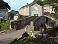 Frank's Bridge
 -
 Kirkby Stephen from the path to Hartley
 -
 River Eden through Kirkby Stephen.


Location grid
[edit]See also
[edit]References
[edit]- ^ a b UK Census (2011). "Local Area Report – Kirkby Stephen Parish (E04002544)". Nomis. Office for National Statistics. Retrieved 10 April 2021.
- ^ UK Census (2001). "Local Area Report – Kirkby Stephen Parish (16UF035)". Nomis. Office for National Statistics. Retrieved 10 April 2021.
- ^ UK Census (2011). "Local Area Report – Kirkby Stephen Built-up area (E34000899)". Nomis. Office for National Statistics. Retrieved 10 April 2021.
- ^ "Key to English Place-names". kepn.nottingham.ac.uk. Retrieved 29 September 2025.
- ^ A Wainwright, Wainwright's Coast to Coast Walk, Michael Joseph, 1987.
- ^ Historic England. "CHURCH OF ST STEPHEN, Kirkby Stephen (1136925)". National Heritage List for England. Retrieved 14 April 2024.
- ^ "Kirkby Stephen, Sports". Archived from the original on 1 January 2010. Retrieved 10 December 2009.
- ^ "Kirkby Stephen Town Council". Kirkby Stephen. Retrieved 17 September 2024.
- ^ "Ward population 2011". Retrieved 21 June 2015.
- ^ City Population site. Retrieved 13 November 2020.
- ^ "Full Freeview on the Caldbeck (Cumbria, England) transmitter". UK Free TV. 1 May 2004. Retrieved 11 October 2023.
- ^ "Freeview Light on the Kirkby Stephen (Cumbria, England) transmitter". UK Free TV. 1 May 2004. Retrieved 11 October 2023.
- ^ "Dales Radio - How to Listen". Retrieved 11 October 2023.
- ^ "Cumberland and Westmorland Herald". British Papers. 18 August 2013. Retrieved 11 October 2023.
- ^ "Cumberland and Westmorland Herald". British Papers. 15 November 2013. Retrieved 11 October 2023.
- ^ "Yomp Mountain Challenge | Upper Eden Rotary Club". www.upperedenrotary.org.uk. Retrieved 23 September 2025.
External links
[edit]- Cumbria County History Trust: Kirkby Stephen (nb: provisional research only - see Talk page)
- The Northern Viaducts - Upper Eden Valley
| International | |
|---|---|
| National | |
| Other | |
Kirkby Stephen
View on GrokipediaGeography
Location and setting
Kirkby Stephen is a market town and civil parish located in the Eden district of Cumbria, England, at coordinates 54°28′18″N 2°20′52″W, with an Ordnance Survey grid reference of NY7708.[7] The town sits in the Upper Eden Valley, surrounded by hill country within the North Pennines Area of Outstanding Natural Beauty and adjacent to the Yorkshire Dales National Park.[8] Positioned along the A685 road, Kirkby Stephen lies approximately 25 miles (40 km) southeast of Kendal and 25 miles (40 km) northwest of Penrith, making it a central hub in the sparsely populated Upper Eden area.[9] The River Eden flows along the eastern edge of the town, providing a natural waterway that originates about 6 miles (9.7 km) to the south in the Mallerstang Valley and supports local scenic and recreational features.[9] As a traditional market town granted a charter in the 14th century, it serves as a key base for visitors exploring the surrounding valleys, fells, and national parks, with facilities including a weekly Monday market, walking trails, and the Upper Eden Visitor Centre offering information on local attractions and accommodations.[8][2] The civil parish encompasses an area of 12.69 km² (3,135 acres), characterized by pastoral landscapes and upland terrain at an average elevation of about 259 meters (850 feet) above sea level.[5][10] This setting positions Kirkby Stephen as a gateway to the broader Eden Valley, facilitating access to outdoor activities while maintaining its role as a self-sufficient community center.[2]Topography and natural features
Kirkby Stephen lies within the undulating hill country of the Upper Eden Valley, characterized by glacial landforms and limestone geology. To the south, the town borders Mallerstang dale, a deep U-shaped glacial valley carved through Millstone Grit plateaus, featuring steep summits, rocky limestone scars, and escarpments along its sides.[11] The surrounding landscape includes sparsely populated fells and moorlands, with Wild Boar Fell rising as the highest nearby point at 708 meters, dominating the western skyline and marking the transition to upland terrain.[12] The River Eden significantly shapes the local geography, rising on Black Fell Moss just south of Kirkby Stephen and flowing northward through the valley in a meandering course amid glacial moraine hummocks and drift terraces. This has formed a narrow floodplain with fertile meadows and influenced the broader vale's gently rolling topography, contrasting with the enclosing uplands of the North Pennines and Orton Fells.[13] The river's dynamics also pose flood risks, with the Upper River Eden flood alert area encompassing low-lying land around Kirkby Stephen, where surcharging tributaries have historically caused inundation.[14] Key natural sites highlight the area's karst features, including Stenkrith Park, where the River Eden descends into a dramatic gorge lined with limestone outcrops, creating whirlpools known locally as the Devil's Mustard Mill.[15] Adjacent to this, the Poetry Path follows the river's course, offering access to these scars and revealing the interplay of water and rock in the limestone landscape. Kirkby Stephen occupies the fringe of the Yorkshire Dales National Park, whose 2016 extension incorporated surrounding fells and dales, enhancing protection for the transitional habitats between lowland and upland.[16] The Eden Valley supports diverse biodiversity, including Atlantic salmon, otters, and white-clawed crayfish in the river, alongside red squirrels, badgers, and birds such as kingfishers and peregrine falcons in the woodlands and grasslands; nearby reserves like Smardale Gill boast over 400 plant species, underscoring the area's ecological richness.[17][18][19]History
Etymology and early settlement
The name Kirkby Stephen originates from the Old Norse compound kirkju-býr, translating to "village with a church" or "church settlement," reflecting the Norse linguistic influence in the region during the early medieval period. The element "Stephen" is likely a dedication to Saint Stephen, to whom the parish church is consecrated, though it may alternatively refer to an early Anglo-Saxon abbot or cleric named Stephen. This etymology underscores the town's foundational role around a religious site, with the earliest recorded form of the name appearing as Cherkaby Stephen around 1090.[20][5][21] Evidence of early settlement points to Anglo-Saxon origins in the region, centered on the parish church, where the first structure is believed to have been constructed around 850 AD, predating widespread Norse arrivals. The site's continuity as a place of worship suggests it served as a focal point for local communities within the broader Anglo-Saxon landscape of northern England. Archaeological findings, including stone sculptures in the church, indicate Christian artistic development from the 8th century onward, bridging pre-Viking and later traditions.[22][23] Viking influence is evident through the Norse-derived place name and regional settlement patterns, with Danish settlers likely establishing or reinforcing the community between 900 and 950 AD. Artifacts such as the Loki Stone—a rare 8th- or 10th-century carving depicting the bound Norse god Loki, preserved in the parish church—provide archaeological hints of pagan Norse beliefs persisting amid Christianization. These elements highlight a cultural transition in the area, where Viking incomers integrated with existing populations.[24][25][26] Prior to the Norman Conquest in 1066, Kirkby Stephen lay within the Kingdom of Northumbria, an expansive Anglo-Saxon realm that encompassed much of northern England and exerted influence over peripheral hill country like the Eden Valley. The area's strategic position is further contextualized by proximity to ancient routeways, including a potential Roman road (Margary 731) running from Sedbergh to Kirkby Stephen, which facilitated earlier connectivity across the Pennines despite no direct evidence of Roman occupation at the site itself.[25][27]Medieval development
The Norman Conquest brought significant changes to Kirkby Stephen, including the expansion and rebuilding of its parish church under monastic influences. Following the Conquest, the income from the parish supported newly revived monasteries, leading to the construction of a new church by monks of St Mary's Abbey, York, sometime in the 12th century and before 1175. This Norman-era structure incorporated early medieval elements, such as the church's foundational layout, which was later modified but retained 12th-century architectural features like rounded arches and robust masonry typical of the period.[24][22] A notable artifact within the parish church is the Loki Stone, a 10th-century sandstone carving depicting the Norse god Loki bound in chains, reflecting the region's Viking heritage amid Christianization. Discovered in 1847 during chancel restoration, the stone—measuring about 6 feet tall and featuring a horned figure with serpents—serves as the shaft of a cross and stands as one of only two known European representations of Loki, symbolizing the transition from pagan to Christian iconography in medieval Cumbria.[28] Economic growth in medieval Kirkby Stephen accelerated with the granting of a market charter in 1352–1353 by King Edward III to Roger de Clifford, Baron of Westmorland, establishing a weekly Monday market and two annual fairs to foster trade in the Upper Eden Valley. This charter enhanced the town's role as a regional hub for wool, livestock, and agricultural goods, spurring population and infrastructural development through the late medieval period. The market privileges were reaffirmed in 1605 by King James I to George Clifford, 3rd Earl of Cumberland, specifying "one market on Monday and two fairs yearly," which solidified Kirkby Stephen's commercial status into the early modern era.[9] Key institutions emerged during the Tudor period, notably the founding of Kirkby Stephen Grammar School in 1566 by Thomas Wharton, 1st Baron Wharton, under letters patent from Queen Elizabeth I. Endowed with lands and revenues from Wharton's estates, the school provided free education in Latin, Greek, and sciences to local boys, contributing to the town's cultural and intellectual advancement amid post-Reformation reforms. The original building, likely repurposed from a tithe barn in Vicarage Lane, operated until the 20th century, exemplifying early modern educational patronage in northern England.[29]Modern history
In the 19th century, Kirkby Stephen experienced modest population growth and economic shifts driven by improved transportation infrastructure, particularly the arrival of the railway. The Settle–Carlisle line, a major engineering feat, opened for freight traffic on 1 August 1875 and for passengers on 1 May 1876, passing directly through the town and establishing Kirkby Stephen station as a key stop.[30] This development stimulated local industries such as limestone quarrying by providing efficient transport links, while also facilitating the rapid movement of livestock and produce to broader markets, thereby boosting trade and supporting the town's agrarian economy.[30] Concurrently, traditional agriculture in the region, dominated by small-scale sheep and cattle farming on inclosed lands and commons, began to decline in its conventional forms; practices like paring and burning for land improvement waned after 1850, with common land use diminishing due to enclosures and a shift toward larger landholdings, leading to reduced reliance on communal grazing and oat-based rotations.[31] The 20th century brought further community-oriented developments, including the establishment of the Yomp Mountain Challenge in 1983 as a 23-mile fell run fundraiser organized by the Upper Eden Rotary Club.[32] Held annually on the fells surrounding Kirkby Stephen, the event originated as a homage to the Royal Marines' long marches over open terrain and has since raised funds for local charities through participant entries and sponsorships, evolving into a multi-day celebration of running, walking, and outdoor activities.[33] Entering the 21st century, infrastructural enhancements enhanced the town's recreational and aesthetic appeal. The Stenkrith Millennium Bridge, a galvanized steel and concrete structure spanning 65 feet and rising 42 feet above the River Eden, was completed and opened in 2002, providing pedestrian access from Frank's Bridge park to trails along the disused South Durham railway.[34] Around the same period, the Eden Benchmarks project installed a series of ten site-specific stone sculptures along the River Eden to mark the millennium; the second sculpture, titled "Passage" by artist Laura White, is located near Kirkby Stephen at NY 7737 0746, serving as both an artistic landmark and functional seating to encourage public engagement with the landscape.[35] Recent milestones reflect ongoing community resilience and investment in the town's vitality. The 2021 Census recorded a parish population of 1,895, indicating stable demographics amid regional trends. In 2024, heritage and tourism received a boost through funded improvement schemes under the UK Shared Prosperity Fund and Rural England Prosperity Fund, including grants for arts, culture, and landscape management plans that enhanced public paths, interpretation panels at sites like Kirkby Stephen railway station, and community facilities to promote visitor experiences.[36] By 2025, local fundraisers demonstrated notable successes, such as the Upper Eden Rotary Club's ongoing Yomp event achieving record participation and charitable contributions in its 43rd year, alongside church restoration efforts like the heating project at Kirkby Stephen Church that secured substantial community donations.[32][37]Demographics
Population trends
The population of Kirkby Stephen civil parish, as recorded in national censuses, has exhibited modest variation over the early 21st century. In 2001, the parish had 1,832 residents. By 2011, this figure had slightly declined to 1,822. The population then rose to 1,895 in 2021, corresponding to an average annual growth rate of 0.39% over the decade from 2011 to 2021.[38][39][40]| Census Year | Parish Population |
|---|---|
| 2001 | 1,832 |
| 2011 | 1,822 |
| 2021 | 1,895 |