
Recent from talks
Mariana Trench
Knowledge base stats:
Talk channels stats:
Members stats:
Mariana Trench
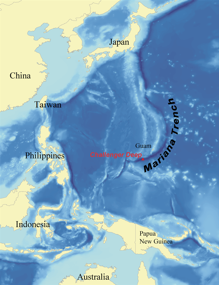
The Mariana Trench is an oceanic trench located in the western Pacific Ocean, about 200 kilometres (124 mi) east of the Mariana Islands; it is the deepest oceanic trench on Earth. It is crescent-shaped and measures about 2,550 km (1,580 mi) in length and 69 km (43 mi) in width. The maximum known depth is 10,984 ± 25 metres (36,037 ± 82 ft; 6,006 ± 14 fathoms; 6.825 ± 0.016 mi) at the southern end of a small slot-shaped valley in its floor known as the Challenger Deep. The deepest point of the trench is more than 2 km (1.2 mi) farther from sea level than the peak of Mount Everest.
At the bottom of the trench at around 11,000 metres below the sea surface, the water column above exerts a pressure of 1,086 bar (15,750 psi), approximately 1,071 times the standard atmospheric pressure at sea level or eight tons per square inch.
The temperature at the bottom is 1 to 4 °C (34 to 39 °F). In 2009, the Mariana Trench was established as a US National Monument, Mariana Trench Marine National Monument.
One-celled organisms called monothalamea have been found in the trench at a record depth of 10.6 km (35,000 ft; 6.6 mi) below the sea surface by researchers from the Scripps Institution of Oceanography. Data has also suggested that microbial life forms thrive within the trench.
The Mariana Trench is named after the nearby Mariana Islands, which are named Las Marianas in honor of Spanish Queen Mariana of Austria. The islands are part of the island arc that is formed on an over-riding plate, called the Mariana plate (also named for the islands), on the western side of the trench.
The Mariana Trench is part of the Izu–Bonin–Mariana subduction system that forms the boundary between two tectonic plates. In this system, the western edge of one plate, the Pacific plate, is subducted (i.e., thrust) beneath the smaller Mariana plate that lies to the west. Crustal material at the western edge of the Pacific plate is some of the oldest oceanic crust on Earth (up to 170 million years old), and is, therefore, cooler and denser; hence its great height difference relative to the higher-riding (and younger) Mariana plate. The deepest area at the plate boundary is the Mariana Trench proper.
The movement of the Pacific and Mariana plates is also indirectly responsible for the formation of the Mariana Islands. These volcanic islands are caused by flux melting of the upper mantle due to the release of water that is trapped in minerals of the subducted portion of the Pacific plate.
The trench was first sounded during the Challenger expedition in 1875 using a weighted rope, which recorded a depth of 4,475 fathoms (8,184 metres; 26,850 feet). In 1877, a map was published called Tiefenkarte des Grossen Ozeans ("Depth map of the Great Ocean") by Petermann, which showed a Challenger Tief ("Challenger deep") at the location of that sounding. In 1899, USS Nero, a converted collier, recorded a depth of 5,269 fathoms (9,636 metres; 31,614 feet).
Hub AI
Mariana Trench AI simulator
(@Mariana Trench_simulator)
Mariana Trench
The Mariana Trench is an oceanic trench located in the western Pacific Ocean, about 200 kilometres (124 mi) east of the Mariana Islands; it is the deepest oceanic trench on Earth. It is crescent-shaped and measures about 2,550 km (1,580 mi) in length and 69 km (43 mi) in width. The maximum known depth is 10,984 ± 25 metres (36,037 ± 82 ft; 6,006 ± 14 fathoms; 6.825 ± 0.016 mi) at the southern end of a small slot-shaped valley in its floor known as the Challenger Deep. The deepest point of the trench is more than 2 km (1.2 mi) farther from sea level than the peak of Mount Everest.
At the bottom of the trench at around 11,000 metres below the sea surface, the water column above exerts a pressure of 1,086 bar (15,750 psi), approximately 1,071 times the standard atmospheric pressure at sea level or eight tons per square inch.
The temperature at the bottom is 1 to 4 °C (34 to 39 °F). In 2009, the Mariana Trench was established as a US National Monument, Mariana Trench Marine National Monument.
One-celled organisms called monothalamea have been found in the trench at a record depth of 10.6 km (35,000 ft; 6.6 mi) below the sea surface by researchers from the Scripps Institution of Oceanography. Data has also suggested that microbial life forms thrive within the trench.
The Mariana Trench is named after the nearby Mariana Islands, which are named Las Marianas in honor of Spanish Queen Mariana of Austria. The islands are part of the island arc that is formed on an over-riding plate, called the Mariana plate (also named for the islands), on the western side of the trench.
The Mariana Trench is part of the Izu–Bonin–Mariana subduction system that forms the boundary between two tectonic plates. In this system, the western edge of one plate, the Pacific plate, is subducted (i.e., thrust) beneath the smaller Mariana plate that lies to the west. Crustal material at the western edge of the Pacific plate is some of the oldest oceanic crust on Earth (up to 170 million years old), and is, therefore, cooler and denser; hence its great height difference relative to the higher-riding (and younger) Mariana plate. The deepest area at the plate boundary is the Mariana Trench proper.
The movement of the Pacific and Mariana plates is also indirectly responsible for the formation of the Mariana Islands. These volcanic islands are caused by flux melting of the upper mantle due to the release of water that is trapped in minerals of the subducted portion of the Pacific plate.
The trench was first sounded during the Challenger expedition in 1875 using a weighted rope, which recorded a depth of 4,475 fathoms (8,184 metres; 26,850 feet). In 1877, a map was published called Tiefenkarte des Grossen Ozeans ("Depth map of the Great Ocean") by Petermann, which showed a Challenger Tief ("Challenger deep") at the location of that sounding. In 1899, USS Nero, a converted collier, recorded a depth of 5,269 fathoms (9,636 metres; 31,614 feet).
Recent media