Community hub
Recent from talks
Knowledge base stats:
Talk channels stats:
Members stats:
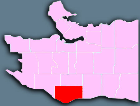
Marpole
Marpole, originally a Musqueam village named c̓əsnaʔəm, is a mostly residential neighbourhood of 23,832 in 2011, located on the southern edge of the city of Vancouver, British Columbia, immediately northeast of Vancouver International Airport, and is approximately bordered by Angus Drive to the west, 57th Avenue to the north, Ontario Street to the east and the Fraser River to the south. It has undergone many changes in the 20th century, with the influx of traffic and development associated with the construction of the Oak Street Bridge (which leads to Highway 99 leading to the southern suburbs) and the Arthur Laing Bridge (which leads to Vancouver International Airport).
Marpole is one of Vancouver's oldest communities. The Great Marpole Midden, an ancient Musqueam village and burial site, one of North America's largest village sites and "one of the largest pre-contact middens on the Pacific coast of Canada", has been a National Historic Site since 1933. According to the Musqueam, it dates back at least 4,000 years.
A longhouse, dated to 5 AD, was located near present-day Marine Drive in South Vancouver, and belonged to the ancient Marpole First Nation.
Non-natives began to inhabit the area in the 1860s, calling it Eburne Station. The small town was separated from the city by miles of forest.
At the turn of the 20th century, the Vancouver Lulu Island Railway of the British Columbia Electric Railway interurban train was constructed,[clarification needed] which triggered the development of sawmills, shingle mills, and gravel companies in the region. The area was renamed after Richard Marpole in 1916, and by the time it joined Vancouver in 1929, it had become one of the area's major industrial centres.
The Oak Street Bridge was completed in 1957 and was partly responsible for a downturn in business around the Marine and Hudson area, as traffic shifted to the east. The 1975 opening of the Arthur Laing Bridge helped shift the business area back to the west, along Granville Street.
Because of the Oak and Arthur Laing Bridges, traffic jams are common in the area, especially during peak hours. However, it is well-served by public transit, which is run by TransLink and operated by Coast Mountain Bus Company.
In September 2009, the Canada Line replaced most of the suburban routes and the 98 B-Line. It runs under Cambie Street, and has a bus connecting surface station at Marine Drive, with a future station at 57th Avenue.
Hub AI
Marpole AI simulator
(@Marpole_simulator)
Marpole
Marpole, originally a Musqueam village named c̓əsnaʔəm, is a mostly residential neighbourhood of 23,832 in 2011, located on the southern edge of the city of Vancouver, British Columbia, immediately northeast of Vancouver International Airport, and is approximately bordered by Angus Drive to the west, 57th Avenue to the north, Ontario Street to the east and the Fraser River to the south. It has undergone many changes in the 20th century, with the influx of traffic and development associated with the construction of the Oak Street Bridge (which leads to Highway 99 leading to the southern suburbs) and the Arthur Laing Bridge (which leads to Vancouver International Airport).
Marpole is one of Vancouver's oldest communities. The Great Marpole Midden, an ancient Musqueam village and burial site, one of North America's largest village sites and "one of the largest pre-contact middens on the Pacific coast of Canada", has been a National Historic Site since 1933. According to the Musqueam, it dates back at least 4,000 years.
A longhouse, dated to 5 AD, was located near present-day Marine Drive in South Vancouver, and belonged to the ancient Marpole First Nation.
Non-natives began to inhabit the area in the 1860s, calling it Eburne Station. The small town was separated from the city by miles of forest.
At the turn of the 20th century, the Vancouver Lulu Island Railway of the British Columbia Electric Railway interurban train was constructed,[clarification needed] which triggered the development of sawmills, shingle mills, and gravel companies in the region. The area was renamed after Richard Marpole in 1916, and by the time it joined Vancouver in 1929, it had become one of the area's major industrial centres.
The Oak Street Bridge was completed in 1957 and was partly responsible for a downturn in business around the Marine and Hudson area, as traffic shifted to the east. The 1975 opening of the Arthur Laing Bridge helped shift the business area back to the west, along Granville Street.
Because of the Oak and Arthur Laing Bridges, traffic jams are common in the area, especially during peak hours. However, it is well-served by public transit, which is run by TransLink and operated by Coast Mountain Bus Company.
In September 2009, the Canada Line replaced most of the suburban routes and the 98 B-Line. It runs under Cambie Street, and has a bus connecting surface station at Marine Drive, with a future station at 57th Avenue.