Hubbry Logo
Canada LineCanada LineMain
Open search
Canada Line
Community hub
Canada Line
logo
8 pages, 0 posts
0 subscribers
Be the first to start a discussion here.
Canada Line
Canada Line
from Wikipedia

Canada Line
Canada Line train pulling into Marine Drive station
Overview
OwnerTransLink, InTransitBC
LocaleMetro Vancouver, British Columbia
Termini
Stations17
Websitethecanadaline.com
Service
TypeRapid transit
SystemSkyTrain
Operator(s)ProTrans BC
Rolling stockRotem EMU, 2 cars per trainset
Daily ridership120,000 (2023)[1]
History
OpenedAugust 17, 2009; 16 years ago (2009-08-17)
Technical
Line length19.2 km (11.9 mi)
Number of tracks2
Track gauge1,435 mm (4 ft 8+12 in) standard gauge
ElectrificationThird rail750 V DC
Operating speed80 km/h (50 mph)
Route map
Map Canada Line highlighted in teal
SeaBus
to Lonsdale Quay
West Coast Express
to Mission
Waterfront
Expo
Line
Vancouver City Centre
Yaletown–Roundhouse
Olympic Village
Broadway–City Hall
King Edward
33rd Avenue (future)
Oakridge–41st Avenue
Langara–49th Avenue
57th Avenue (future)
Marine Drive
Vancouver Zone 1
Richmond Zone 2
North Arm Bridge
over Fraser River
Operations and
maintenance centre
Bridgeport
Capstan
Aberdeen
Lansdowne
Richmond–Brighouse
Middle Arm Bridge
over Fraser River
Templeton
Sea Island Centre
YVR Terminal 3 (future)
YVR–Airport
Vancouver International Airport

Handicapped/disabled access All stations are accessible

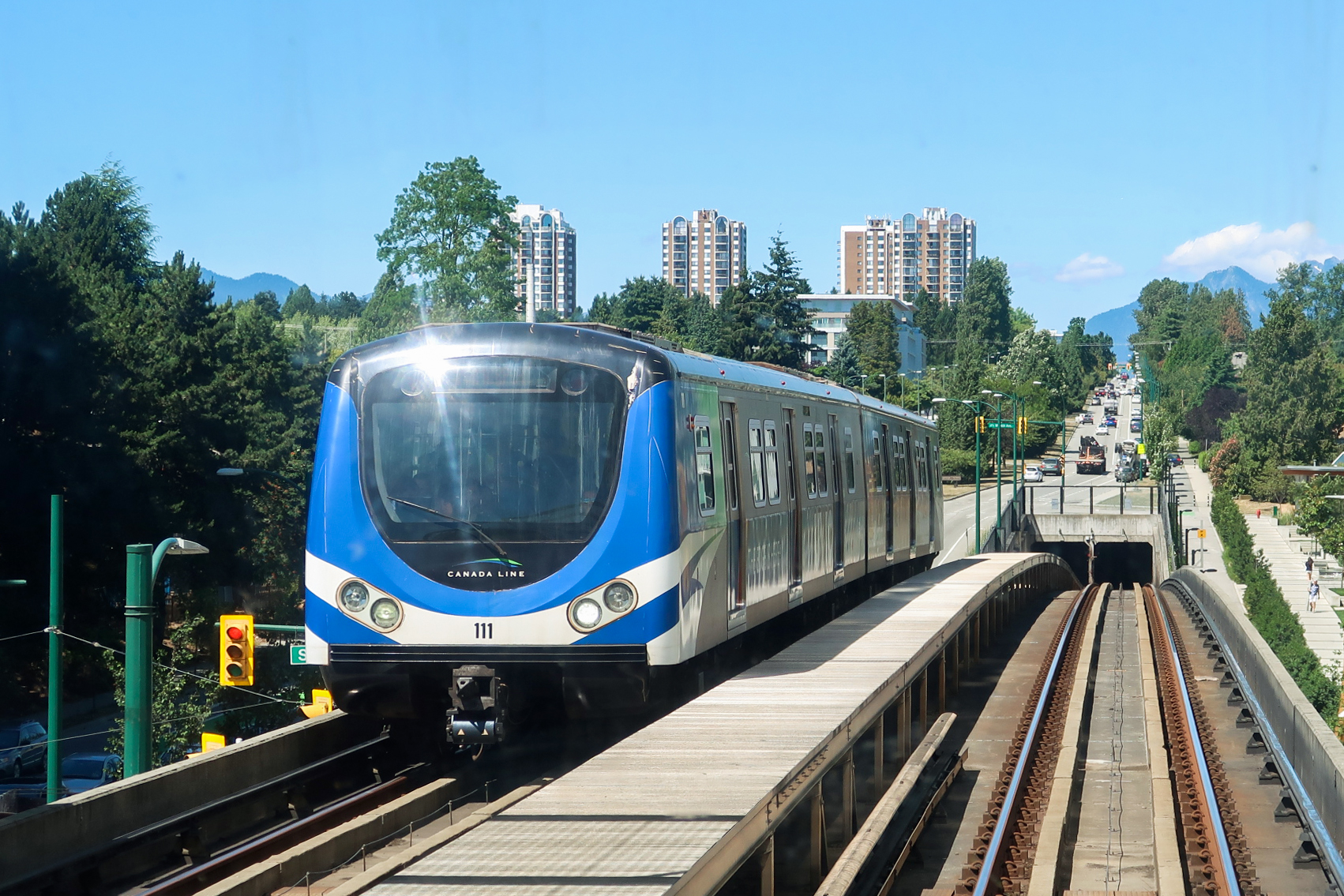
The Canada Line is a rapid transit line in Greater Vancouver, British Columbia, Canada, that is part of the SkyTrain system. The line is owned by TransLink and InTransitBC and is operated by ProTrans BC. Coloured turquoise on route maps, it operates as an airport rail link between Vancouver, Richmond, and the Vancouver International Airport (YVR). The line comprises 16 stations and 19.2 kilometres (11.9 mi) of track; the main line runs from Vancouver to Richmond while a 4-kilometre (2.5 mi) spur line from Bridgeport station connects to the airport.[2] It opened on August 17, 2009, ahead of the 2010 Winter Olympics.[3]

The Canada Line was anticipated to have 100,000 boardings per day in 2013 and 142,000 boardings per day by 2021, but it has consistently exceeded early targets.[4] Ridership has grown steadily since opening day, with average ridership of 83,000 per day in September 2009,[5] 105,000 per day in March 2010,[6] and over 136,000 passengers per weekday in June 2011.[7] During the 17 days of the 2010 Winter Olympics, the line carried an average of 228,190 passengers per day.[8]

Governance of the project was through Canada Line Rapid Transit Inc. (CLCO), formerly RAV Project Management Ltd. (RAVCO), a reflection of the original "Richmond–Airport–Vancouver" name).[9] The line was built by SNC-Lavalin, and InTransitBC is under contract with TransLink to manage the line for its first 35 years, until 2044. The Canada Line is operationally independent from British Columbia Rapid Transit Company, which operates SkyTrain's Expo and Millennium lines[10] but is considered a part of the SkyTrain network. Like the other two SkyTrain lines in Metro Vancouver, it is also light metro rapid transit, using fully automated trains on grade-separated guideways.[11] However, the trains are powered by conventional motors with third rail electrical pickup rather than the linear induction system used on the other SkyTrain lines.

Route

[edit]
Canada Line bridge over the Fraser River

The Canada Line begins in Downtown Vancouver at Waterfront station (0.0 km [0 mi]) in a cut-and-cover subway tunnel beneath Granville Street. It quickly goes into twin-bored tunnels, heading southwest beneath Granville Street, then curving southeast to follow Davie Street through Yaletown. The tunnels then dive deeper to pass below False Creek before rising back up to Olympic Village station (2.7 km [1.7 mi]). There, the line transitions back to a cut-and-cover tunnel (which is noted by the tunnel changing from a circular to a square shape), heading south under Cambie Street. This section has some portions where the two sets of tracks are stacked vertically. The line emerges from the ground just south of 64th Avenue, climbing to an elevated guideway.[12]

The line continues elevated across the North Arm Bridge over the North Arm of the Fraser River, leaving Vancouver and entering Richmond. Just beyond Bridgeport station (11.1 km [6.9 mi]) at a flying junction, the line splits, with the Richmond branch heading south on elevated tracks along No. 3 Road and terminating at Richmond–Brighouse station (14.5 km [9.0 mi]). The airport branch turns west and crosses the Middle Arm Bridge over the Middle Arm of the Fraser River, connecting to stations on Sea Island and terminating at YVR–Airport station (15.0 km [9.3 mi]). Portions of the airport branch are at grade in order to accommodate a future elevated taxiway for aircraft over the line. Both branches narrow to a single track as they approach their respective terminus stations. Just before Bridgeport station is the Operations and Maintenance Centre (OMC) facility, which houses Canada Line trains that are not in use.

Stations

[edit]

Station construction was designed as a two-stage process. Sixteen original stations opened at the same time as the line did. Three additional stations are planned, and may be built in the future. The stations are listed below.

Each Canada Line station is slightly different in appearance, designed to blend in with the surrounding neighbourhood. For example, Langara–49th Avenue station is designed to fit into the area's low-density residential neighbourhood.[citation needed]

The five busiest stations have platforms 50 metres (160 ft) long, while the rest of the stations have 40-metre (130 ft) platforms that can be easily extended to 50 metres. The termini at YVR–Airport and Richmond–Brighouse stations are single-tracked, whereas the Waterfront station terminus is double-tracked. The double-tracking is necessary to accommodate the three-minute headways between trains on the Waterfront–Bridgeport portion of the line. King Edward station is the only station with a stacked configuration, and Broadway–City Hall station is the only station with a double-height ceiling over the platforms. Vancouver City Centre station is linked to Pacific Centre mall and Vancouver Centre Mall, in addition to having street level access. All direct transfers to the Expo and Millennium Lines must be made at Waterfront station; there is no direct connection from Vancouver City Centre station to Granville station. However, it is possible to transfer between those two stations via a short walk through Pacific Centre or Vancouver Centre Mall.

Stations were configured to allow for the future installation of fare gates, and received fare gates in 2013 as part of full implementation throughout all SkyTrain stations. Every station has an up escalator and an elevator, but only the three terminal stations have down escalators.[13]

Until late 2019, six stations (Vancouver City Centre, Olympic Village, Broadway–City Hall, Marine Drive, Templeton, and YVR–Airport) were equipped with self-service flight check-in kiosks which allowed customers to check into their flights at Vancouver International Airport while at these stations.[14][15]

Station City Connections Location
Waterfront Vancouver Granville, between Pender and Hastings
Vancouver City Centre Granville at Georgia
Yaletown–Roundhouse Davie near Mainland
Olympic Village Cambie at West 2nd Ave
Broadway–City Hall 99 B-Line Cambie at West Broadway
King Edward Cambie at King Edward
Oakridge–41st Avenue R4 RapidBus Cambie at West 41st; next to Oakridge Centre
Langara–49th Avenue Cambie at West 49th; near Langara College
Marine Drive Cambie at Marine
Bridgeport Richmond Major transit exchange for suburban buses; branches split; adjacent to River Rock Casino Resort
Richmond–Brighouse branch
Capstan Richmond No. 3, between Capstan and McMyn[16]
Aberdeen No. 3 at Cambie; adjacent to Aberdeen Centre
Lansdowne No. 3 at Lansdowne; adjacent to Lansdowne Centre
Richmond–Brighouse No. 3 at Saba; adjacent to Richmond Centre
YVR–Airport branch
Templeton Richmond North of Grant McConachie Way; east of Templeton
Sea Island Centre Near Air Canada service centre
YVR–Airport Vancouver International Airport YVR Adjacent to Grant McConachie Way, attached by walkways to YVR Main Terminal

Additional stations

[edit]

Provisions have been made to allow for the addition of the following infill stations in the future:

  • 33rd Avenue (Cambie Street at West 33rd Avenue, next to Queen Elizabeth Park)[17]
  • 57th Avenue (Cambie Street at West 57th Avenue)[17][18]
    The future of a 57th Avenue (Cambie Street and West 57th Avenue) in Vancouver is not fully known at this time. The original plan was that one day a station could be built, but new documents and talk between TransLink and the City of Vancouver raise the possibility of it never happening. The station was part of the broad policy statement adopted in 2014 by city council for the redevelopment of the Pearson Dogwood lands. But in June 2017 Susan Haid, city assistant director of planning for Vancouver South, submitted a report to Vancouver council stating that "though it is desirable to achieve a future station at 57th Avenue there are a number of key challenges," Haid wrote in her report. "Currently, the station is not considered in regional transportation plans and is not considered a regional priority such as the Broadway Corridor line." Haid also added to her report that, "Should the station not be attainable in the long-term future, the financial contribution towards a future station would be re-allocated to address the amenity priorities identified for Pearson Dogwood and those in and around the Cambie Corridor consistent with the respective public benefit strategies."[19]
  • YVR Terminal 3 (near YVR Terminal 3)
    The master plan for the Vancouver International Airport for 2027 indicates that this station would be built alongside the airport's proposed Northeast Terminal expansion.[17][20]

Transit connections

[edit]
Map of the Canada Line as of January 2025

Many transit services connect with the Canada Line and form an important part of the service. With the opening of the line, most bus routes in Richmond, and connecting services from White Rock, Tsawwassen, and Ladner, doubled their service frequency. Waterfront station provides connections to the R5 Hastings St, Expo Line, West Coast Express, and SeaBus. Broadway–City Hall provides a connection to the 99 B-Line service.

There are currently only two routes serving Vancouver International Airport: the N10 NightBus, running parallel to the Canada Line along Granville Street, and route 412, running between Airport South and Bridgeport station.[21][22] Riders on these bus routes are not subject to the YVR AddFare.[23] The Airport Station exchange was downgraded to a regular bus stop on September 7, 2009, a few weeks after the opening of the line. Bus routes that used this loop were discontinued (as in the case of the 424 and the 98 B-Line), short-turned (as in the case of the 100, renamed 100 Marpole Loop), or redirected to Bridgeport station (as in the case of the 620, C90, and C92).[24]

Work began in May 2021 to extend the Millennium Line from VCC–Clark station west along Broadway to the new Arbutus station, allowing for a transfer to the Canada Line at Broadway–City Hall station.[25] As indicated in material presented by the City of Vancouver at public meetings in early 2006, this station was designed with such a future extension in mind. A "knock-out" panel was installed in the concourse that would facilitate construction of a connection between the station and a Broadway-corridor SkyTrain extension.

The Canada Line uses the same fare system as the rest of the transit system managed by TransLink, with two exceptions:[26]

  • The YVR AddFare, started in January 2010, is a surcharge that applies to some passengers leaving the airport and travelling eastbound to Bridgeport station and beyond. Passengers headed away from the airport must pay a $5 AddFare on top of the regular fare to leave the Sea Island stations unless they are travelling on a monthly pass; or a DayPass or a single-use Compass Ticket that was not purchased on Sea Island.
  • Travel between the Sea Island stations is free to everyone. There is no additional fare for passengers travelling toward the airport. Such trips require a special Sea Island ticket that is free to obtain at any ticket machine at the Sea Island stations. These tickets are not valid for tapping out at other stations; an exit ticket is required for Sea Island ticketholders exiting at any station outside of Sea Island.

The Canada Line operates on a "Fare Paid Zone" system. Passengers are required by law to possess a valid fare when they are in Fare Paid Zones. Fare Paid Zones are clearly marked, and fares can be bought from Compass Vending Machines at all stations. Fare inspections are mostly conducted by the South Coast British Columbia Transportation Authority Police Service. Passengers who fail to pay the fare or do not have a valid fare may be fined $173 and/or removed from the station or train.[27]

Canada Line attendants are the customer service staff for the Canada Line. They are easily identifiable by their green uniforms. They provide customer service, troubleshoot certain problems with the trains, observe and report safety issues, and check fares.

Technology

[edit]
A train parked at the Canada Line Operations and Maintenance Centre near Bridgeport station

The Canada Line uses a fleet of trains built by Rotem, a division of Hyundai Motor Group. The trains are powered by conventional electric motors, rather than the linear induction motors used by the Expo and Millennium Line's Bombardier ART trains. Canada Line trains are operated by the same SelTrac automated train control system used in the rest of the SkyTrain network.

The selection of Rotem was largely a consequence of the request for proposals process for the public-private partnership, whose terms did not allow Bombardier to consider efficiencies in combining operations or rolling-stock orders for the new line with those for the existing system.[28] This placed all bidders on a level playing field, albeit at the cost of not necessarily picking the most efficient choice for long-term operation. The RFP also required that the system have a capacity of 15,000 passengers per hour in each direction (leaving the choice of technology and platform length to the proponent) and a maximum travel time between the airport and downtown Vancouver of 24 minutes.[29]

The fleet consists of 32 fully automated two-car articulated trains, for a total of 64 cars.[30] The capacity of the trains is estimated at 334 people per pair of cars (comfortably) or 400 people at crush load. The trains have a top speed of 80 kilometres per hour (50 mph) in normal operation and 90 kilometres per hour (56 mph) in catch-up mode.[31] Each married pair of gangway-connected cars is 41 metres (134 ft 6 in) long and 3 metres (9 ft 10 in) wide, and longer and wider than the Bombardier ART fleet used on the Expo and Millennium lines.[32] Each train has LED electronic displays on the exterior to indicate the terminus station and on the interior to display the next station and the terminus station, a useful feature considering the line has two branches.

In 2018, twelve additional trainsets were ordered by Translink from Hyundai Rotem at a cost of $88 million to increase capacity on the line.[33] The sole-source contract allowed for commonality between the two train models, and reduced the number of specialized tools and parts required.[34] These were delivered in 2019 and 2020.[35][36]

Canada Line Hyundai Rotem specifications

[edit]

Name

[edit]

During the planning and public consultation stages, the line was known as the "Richmond-Airport-Vancouver Line", or RAV for short. The name "Canada Line" was adopted in 2005 to coincide with the beginning of construction.[41] Some early documents also refer to it as the "Olympic Line",[42] in recognition of the 2010 Winter Olympics, continuing the practice by which the Expo and Millennium lines were named after significant events occurring at the time of construction. This name was adopted for the demonstration modern streetcar service that operated along the Downtown Historic Railway for a two-month period centred on the Olympics.[43]

Timeline

[edit]
  • Between 1990 and 1992, BC Transit and N. D. Lea (now WSP Global) consultants studied intermediate-capacity transit system options in the Vancouver–Richmond corridor.[44]
  • From September 1991 through August 1993, the TRANSPORT 2021 Steering Committee carried out an extensive program of research and public consultation to create "A Long Range Transportation Plan for Greater Vancouver". Under Project Director M. L. (Martin Crilly), a comprehensive transportation investment and financing strategy was envisioned for the region. Until today all existing and proposed road and transit investments have been put forth in this plan. The plan calls for the provision of an intermediate-capacity transit system from Richmond to Vancouver's central business district.[45]
  • In fall of 1994, N. D. Lea and Delcan consultants carried out studies examining technologies, operating feasibility, ridership, capital and operating costs, traffic impacts, and development potential in three corridors, including the Richmond–Vancouver corridor. These studies were prepared as input into BC Transit's 10-Year Development Plan. They did not include a spur line to the Vancouver International Airport.[46]
  • In 1995, BC Transit (a crown corporation responsible for public transit) expressed a desire to create a special bus rapid transit (BRT) or automated rapid transit (ART) service connecting the cities of Richmond and Vancouver and the Vancouver International Airport in one of the transit improvement plans.
    • Underground rights-of-way were reserved at the Concord Pacific development close to the Cambie bridge.
  • From mid-1997 to mid-1998 a number of BRT routes for Vancouver-airport/Richmond were evaluated, and the preferred route and station locations were selected.[47]
  • June 24, 1998, the minister in charge of BC Transit, Joy MacPhail, announced plans to build a Vancouver–Richmond ALRT: "The new line would link Richmond city centre, the airport and Downtown Vancouver—probably running north-south through Vancouver along the Cambie Street corridor." "MacPhail said the province wants to accelerate the construction of rapid transit to Richmond as part of a bid to bring the 2010 Winter Olympics to the Lower Mainland."[48]
  • In 1999, detailed design of the Vancouver-Airport/Richmond BRT was carried out.
  • On April 1, 1999, The Greater Vancouver Transportation Authority (TransLink) was created under the direction of CEO Ken Dobell, previously city manager for the City of Vancouver.
  • In April 2000, TransLink adopted its Strategic Transportation Plan 2000–2005. The plan noted that future transit lines have equal priority, and recommended the planning and design of a Richmond-Airport-Vancouver (RAV) rapid transit line.
  • May 2000 saw the approval of the RAV study, while construction had begun on the BRT service between Richmond Centre, Airport Station exchange, and downtown Vancouver.
  • In 2000, a Transport Canada report on rail access to the airport estimated it would cost $1.3 billion for a SkyTrain expansion using the Cambie route and $738 million for a light rail system along the Arbutus corridor.[49]
  • In December 2000, TransLink received the report on public-private partnerships for road and transportation infrastructure, the model that would be used to finance, construct, and operate the new Canada Line.
  • On April 1, 2001, bus operators and other CMBC employees went on strike, delaying full implementation of the Vancouver-Airport-Richmond BRT by four months.
  • That same month, TransLink reaffirmed a Vancouver–Richmond line including a connection to the airport, and approved a recommendation by the TransLink CEO that, based on greater benefits from a private-sector perspective and community concerns, at-grade rail transit be excluded from further analysis and that analysis in Vancouver be restricted to underground options.
  • On August 1, 2001, the 98 B-Line BRT service began service in the corridor, ultimately carrying over 20,000 passengers per day, while plans were already under way for an ART service to replace it. This proposed service was projected to carry over 100,000 passengers per day.
  • On December 10, 2001, the federal government under Jean Chrétien announced over $2.0 billion in funding for large infrastructure projects; the Canada Strategic Infrastructure Fund established by this budget would fund the federal government's contribution to the Canada Line. The government stipulated that the fund promote private-public partnerships where appropriate.[50]
  • In April 2002, work was started on the third phase, project definition. This ten-month task consisted of a technical evaluation to determine if it was possible to build the line by 2010.
  • In 2003, ten companies or consortia submitted expressions of interest in the project.
  • In December 2003, this was shortlisted to the following three consortia, which were given a request for proposal:
  • On April 16, 2004, the federal government under Prime Minister Paul Martin increased its funding promise from $300 million to $450 million.[51][52]
  • On June 10, 2004, the provincial government restated its commitment to the Canada Line, increasing funding from $300 to $370 million, and earmarked $170 million for the Evergreen Line.[53][54]
  • On June 30, 2004, after twice voting to cancel the project, the TransLink Board approved the RAV line but maintained the right to cancel the project if none of the bids met the approved budget of $1.35 billion.
  • On November 19, 2004, RAVCO recommended that the SNC-Lavalin/Serco (now known as InTransitBC) proposal for a fully automated, grade-separated system be accepted. This "best and final offer" bid was $343 million over the approved budget. The project was, however, brought within the funding allowance through various cost-trimming measures, including design changes, the contractor agreeing to lower its bid, and the province contributing another $65 million.
  • On December 1, 2004, the TransLink board gave final approval for the project.
  • On July 29, 2005, the final contract to design, build, and operate the RAV Line was signed by InTransitBC and TransLink. Serco was no longer a partner to InTransitBC, and two pension funds were brought into the partnership.
  • In October 2005, the utilities relocation and road work was started.
  • On November 25, 2005, the design of the new trains was unveiled, and Hyundai Rotem was announced as the supplier of the trains. It was announced that the new line would be called the Canada Line as a funding condition from the federal government.[28]
  • The line opened at 1 p.m. local time on August 17, 2009, on budget and three and a half months ahead of schedule, and six months ahead of the 2010 Winter Olympics held in Vancouver. It began normal revenue service on the following day.
  • On September 30, 2009, it was announced that the Canada Line had seen an average of 82,500 passengers per day since opening, putting it well on track to reach its ridership target of 100,000 per day within two years.[5]
  • On December 28, 2009, it was revealed that the average daily ridership (including weekends) has grown to 93,000 and has occasionally exceeded 100,000, three years ahead of expectations.[55]
  • On February 5, 2010, ridership reached a (then) record of 135,000 during a campaign to encourage residents to use transit prior to the Olympics.[56] Further single-day records included 157,000 on February 11, 2010,[57] and 210,000 on February 15, 2010, with all 20 trains running.[58]
  • Overall, the 2010 Winter Olympics saw the Canada Line's ridership increase by 118 percent to an average of 228,190 per day for 17 days, with a single-day record of 287,400 on February 19, 2010. Its regular non-Olympic ridership was stated as being 104,674 per weekday.[8]
  • In February 2011, Translink revealed that the average daily ridership of the Canada Line had grown to 110,000 per day.[59]
  • In September 2021, construction began on Capstan station at Capstan Way; the station opened in December 2024.[60]

Project funding

[edit]

The Canada Line was built as a public-private partnership. Funding was provided by both government agencies and a private partner, the proponent. As of March 2009, the entire project was expected to cost $2.054 billion. The premier of BC stated that the project was on budget and ahead of schedule.[61] When approved in December 2004, the cost was given as $1.76 billion.[62]

The public contributions to the budget come from the following sources:

These sums are all in 2006 dollars, except for the government of Canada's contribution, which will be paid out when constructed, and is estimated to be equivalent of $419 million 2003 dollars.[64]

The private partner was expected to contribute $200 million, and be responsible for any construction cost overruns.[65] As of November 7, 2009, InTransitBC has invested $750 million. InTransitBC is a joint venture company owned by SNC-Lavalin, the Investment Management Corporation of BC (bcIMC), and the Caisse de dépôt et placement du Québec.[66][67]

The BC government had committed $370 million, but when the bid came in over budget, it contributed an extra $65 million. TransLink also put in extra money by committing money from the sale of the Sexsmith Park and Ride in Richmond and from the introduction of a special fare in the Airport Zone.[62]

In November 2004, bid costs were reduced by postponing the construction of a walkway between Waterfront station and the cruise ship terminal, removing Westminster station, and moving Richmond Centre station and the end of the line several hundred metres north. TransLink would further pay for the cost of reinstallation of the trolley wires along Cambie. As a way to further reduce the best and final offer, RAVCO no longer required that the proponent provide for 59 ticket vending machines and 38 ticket validating machines or for a police unit to operate on the RAV line. RAVCO also shifted responsibility for moving trolley wires from SNC-Lavalin to TransLink.[68] Costs were also decreased due to decisions to single-track sections on the Richmond and airport branches. The Richmond branch was single-tracked from Ackroyd Road onward in large part due to Richmond's city council pressuring for the visual profile of the overhead line to be reduced for esthetic reasons.

On July 11, 2006, a decision was made to relocate Broadway station half a block north at a cost of $3 million to allow for better integration of the station with Broadway and a new development in the area. The funding was provided as follows: one third from the City of Vancouver, one third from TransLink, and one third from surplus funding available to CLCO.[69]

In February 2007, TransLink approved the addition of a pedestrian and bicycle path to the Canada Line Bridge and agreed not to postpone the construction of a station at 2nd Avenue (Olympic Village station), but instead build it to be ready when the line opens. The $10 million cost of the bridge bike path was paid for by TransLink and not considered part of the cost of the Canada Line. The Olympic Village station cost an additional $29 million.[70]

RAVCO was set up by the agencies funding the transit line to oversee project design, procurement, construction, and implementation. This TransLink subsidiary, later renamed Canada Line Rapid Transit Inc (CLCO), made distributions to the builder as work progressed.

The table below lists the year-by-year contributions (in millions of dollars) made by various governments on a year-by-year basis up to December 31, 2008.[71][72] Contributions by TransLink are total disbursements minus contributions from the City of Vancouver, the government of British Columbia, and the government of Canada. Calculations show that TransLink has contributed $271 million to date. It has committed an additional $52 million in its 2009 budget.

Year Vancouver BC government Canadian government Total disbursements through TransLink Airport disbursements
2008 $7.1 $59.6 $93.4 $163.2 $46.8
2007 $14.9 $58.4 $167.4 $336.7 $94.6
2006 $6.9 $17.2 $125.6 $322.5 $108.4
2005 $1.1 $117.1 $108.9 $209.4 $15.7

The private sector will operate the line for 35 years in return for a share of its operating revenue.

In early 2006, TransLink decided not to install turnstiles at Canada Line stations, but stations would be designed to accommodate controlled access to allow TransLink to install them for less cost if it wished to do so in the future.[73] On April 9, 2009, TransLink, the provincial government, and the government of Canada announced joint funding of $100 million to introduce turnstiles at all 49 SkyTrain stations.[74] While a large portion of this funding will be used on the Expo and Millennium Lines, a portion will be used on the Canada Line stations. The federal government is contributing $30 million and the province is adding $40 million toward fare gates, or controlled access gates.

Construction

[edit]

Construction began in October 2005 and was completed in August 2009.

At initial completion, the line comprised the following construction elements:

Segment type Length
Tunnel 9,080 m
(29,790 ft)
Elevated 7,349 m
(24,111 ft)
Bridge 614 m
(2,014 ft)
At-grade 1,385 m
(4,544 ft)

In addition to the 18.4 kilometres (11.4 mi) of track above, there are about 500 metres (1,600 ft) of track in the OMC.

Controversies

[edit]

Opponents have claimed that the approval process was undemocratic and dishonest. In 2004, critics said that the projected ridership figures were grossly inflated;[75] ridership projections were exceeded in 2010 and subsequent years.[6][7] Opponents also argued that the official claim that the project had nothing to do with Vancouver's bid to host the 2010 Winter Olympics was not credible.[76]

Public-private partnerships

[edit]

Opponents of the RAV line's public-private partnership (P3) believe it was politically motivated and that it will cost more money because of the private involvement. However, the private involvement allowed for construction costs to be known and fixed up front. After raising its contribution to $435 million, the BC minister of transport and premier reaffirmed that this was the final contribution and that any cost overruns would be the responsibility of the proponent.[77] The Canadian Union of Public Employees opposed the use of a P3 to design, build, and operate the Canada Line. The P3 process did not allow precise plans to be developed with public consultation, but limited discussion to certain abstract parameters, while leaving actual design details to the private partner.

Ridership projections

[edit]

Before the building of the line, TransLink had projected that it would require a 100,000 passenger/day average to reach the "break even point". They also projected that it would take about three years for capacity to reach this point and that TransLink would be responsible for the loss. However, the Canada Line reached its projected ridership goal in late 2010, three years early.[78] In 2017, TransLink CEO Kevin Desmond suggested that the Canada Line was underbuilt for its ridership, especially because more people moved into transit-oriented developments along the line following its completion.[79] In 2019, former Vancouver city councillor Gord Price noted that the desire to have the line open in time for the 2010 Winter Olympics, as well as not exceeding the budget, led to cautious decision making.[80][81] In 2018, 12 additional trainsets were purchased to increase capacity on the line by 35 percent.[82][36]

Alignment and grade separation

[edit]

Vancouver

[edit]

Although the latest proposal for rapid transit did not include an option for rapid transit down the Arbutus corridor along the abandoned CPR right of way, Vancouver council reopened debate on this issue. Given that the rail right of way is currently zoned for transit use with space available for transit lines, running the line down the Arbutus corridor may have been more cost-effective than tunnelling under Cambie. The planners and RAVCO, however, countered that the Arbutus corridor does not have the major concentration of transit destinations and origins that exist along the Cambie Street corridor, such as Vancouver City Hall, Vancouver General Hospital, Oakridge Centre, and Langara College, which are necessary to provide the ridership required for this project to be successful. Also the Arbutus corridor is longer than the Cambie corridor and would cause longer travel times. The Cambie corridor further had greater potential for future ridership growth.[83]

The Project Definition Report further specified that any service had to be able to travel from Waterfront station in downtown Vancouver to the airport in 25 minutes or less. At-grade transit, either along Cambie or the Arbutus corridor, was ruled out as a result. The reason or origin for this exact requirement was not specified, although travel times were considered an important factor in attracting new riders and in retaining existing riders, who were now required to make an extra transfer relative to the existing bus service.

All partner contributions were made upon the specifications set in the Project Definition Report. Any "significant change" would allow each partner to reconsider its respective contribution. As the Arbutus corridor proposal could not meet the specifications, this could put participation of funding partners in jeopardy.

Residents along Cambie Boulevard created the Cambie Boulevard Heritage Society in 1994, which opposed any alteration to a wide green centre median that is currently a grassy area with various species of trees, including cherry trees donated by the City of Yokohama on occasion of the 1967 Canadian Centennial. The residents had already been mobilized in 1989 in response to the possibility of elevated rail along Cambie Boulevard.[84] In effect the residents were opposed to surface, trench, or elevated rail along much of Cambie Street. Even cut-and-cover construction raised concerns over construction impacts and temporary traffic diversions. Cost and ridership risks were also concerns to property tax–paying residents. Advertisements asked residents to join "to prevent Vancouver's worst traffic nightmare and from burdening ourselves and our children with unnecessary tax risks for years to come". The society suggested that the line instead be constructed along Arbutus, where its impact and cost would be minimal.[85] Despite the society's concerns, one of the final two proposals for the Canada Line in 2004 involved a trench in the centre of Cambie Street from 49th to 64th Avenues.

On June 18, 2004, the TransLink Board voted 6–6 to oppose sending the project to the "best and final offer" stage. Opponents of the project favoured a proposal to build a line along the Cambie corridor involving a minimal amount of tunnelling, at a saving of about $300 million over the previously fully grade-separated proposal. The province responded to the suggestion by withdrawing funding until after the 2010 Olympics; Minister of Transport Kevin Falcon said that such a change of scope could no longer be accommodated in the time left before 2010. Mayors and councillors sitting on the TransLink Board, however, could not come to an agreement on this alternate plan of action.[86] The impasse created a stir in the business community, which joined together and called for the province to take over control of the project. "The Coalition FOR a Lower Mainland Rapid Transit Solution" in a newspaper ad called on the premier to "please rescue our rapid transit". The Vancouver Board of Trade, the Council of Tourism Associations, and Tourism Vancouver led the call on the premier.[87] While the board ultimately voted to proceed, the incident had lasting repercussions for TransLink.

Richmond

[edit]

When the results of the bidding process indicated that an elevated option in Richmond was the winning bid, Richmond council engaged in some last-minute opposition to the RAV line and refused to give RAVCO the green light.

Objections to the elevated line included its visual impact and the impact and cost of any extensions into Richmond. The line would have varied impact on businesses along No. 3 Road.

In November 2004, a survey of 11,750 people was conducted by RAVCO to determine if people in Richmond supported an elevated or at-grade service in Richmond. Of the respondents, 58 percent favoured an elevated option.[88]

Closure and dismantling of 98 B-Line busway on No. 3 Road at Capstan Way to make way for Canada Line, April 2006

Even after the survey, however, another option was brought forward. On November 22, 2004, Richmond council considered whether an elevated guideway along No. 3 Road in Richmond was appropriate. If an at-grade service was not feasible, council had instructed staff to look into the possibility of relocating the elevated guideway further west, along Minoru Boulevard. In response, residents along Minoru Boulevard presented a petition containing 666 signatures opposing the Minoru alignment. In the petition they "indicated that if Translink and RAVCO were not prepared to construct an at-grade system on No. 3 Road, then the project should be abandoned in favour of bus service on No. 3 Road."[89]

When further surveys and public consultation conducted by city staff in December indicated that residents did not support the realignment along Minoru Boulevard, council was left to either turn down the development or support the best and final offer. They chose to go ahead with the project. As a final compromise, part of the elevated track in Richmond was single-tracked to reduce visual impact.

Impact on local businesses

[edit]
One side of the street was cut off from traffic and parking was affected.
The "business is open" logo

For the entire consultation process, it was assumed that any underground construction along the Cambie corridor would be by bored tunnel.[citation needed] It was only upon the publication of the winning bid that it became apparent that the portion of the line from 64th to 2nd Avenues would be constructed using cut-and-cover construction. This raised concern over the disruption of local business on Cambie Street. Businesses in Yaletown and No. 3 Road in Richmond would also be affected by the construction. Although construction in the downtown was mostly by bored tunnel, businesses in Yaletown were caught off guard when it turned out that Yaletown-Roundhouse station would be north of Pacific Boulevard on Davie Street, rather than south of Pacific Boulevard.[90] InTransitBC responded by launching an advertising campaign promoting local business on the line.[91][92] Despite these efforts, businesses on Cambie Street experienced significant loss of business. After numerous failed appeals to the provincial government for compensation, store operators unsuccessfully sued for compensation. However, since the completion of the Canada Line, the line has been linked to rising property values along Cambie Street and in Richmond.[93]

Impact on expansion of other transit options

[edit]

It had been pointed out that construction of the Canada Line would do little to improve transit or alleviate congestion on the Broadway corridor to UBC, which serves more than 100,000 weekday trips on bus services, with many trips continuing to University of British Columbia. In addition, the Evergreen Extension rapid transit project was delayed (until 2016). As TransLink is solely responsible for funding bus operations, any shortage of funding may translate into cuts in bus service.

Hiring practices

[edit]

There were several labour disputes related to wages and unionization between employees and contractors working on the construction of the Canada Line. To excavate the final 2 kilometres (1.2 mi) of the tunnel underneath the downtown core a crew of 36 Latin American workers were brought to Canada from Costa Rica, Ecuador and Colombia in April 2006. The employer, a joint partnership of SELI Canada and SNC (Pacific) engaged workers to assemble the tunnel boring machine (TBM) and begin excavations. Pay stubs and testimony evidence from the workers indicated that they were paid US$1,000 monthly in exchange for 65-hour work weeks (less than $4 per hour). The Latin Americans, all on temporary work permits, joined the Construction and Specialized Workers Unions Local 1611 and, in a majority vote, won union certification on June 23, 2006. This was the first time in Canadian history that a group of temporary foreign workers in the construction industry had successfully exercised their right to form a union. Before the union had a chance to begin collective bargaining, workers' wages were increased to $14.21 per hour and hours were reduced to 40 hours per week with overtime concessions as required by BC labour law. The union was not consulted, and the unilateral pay raise led to an unfair labour practice complaint from the CSWU 1611. The BC Labour Relations Board (BCLRB) sided with the employer's (SELI–SNCP) explanation that there had been a mistake in calculations of wages during the months before the workers voted to join the union. The employer stalled negotiations for a collective agreement until they were ordered back to the bargaining table in August 2006 by the BCLRB.[94]

In September, bargaining broke down. On September 21, 2006, CSWU 1611 workers threatened a strike vote to bring the employer back to the bargaining table.[95]

After almost two years of litigation, the BC Labour Relations Board ruled against the union's claims of unfair labour practices.[96]

In a separate complaint, the union claimed discrimination against the workers based on their country of origin. Even with the newly imposed wage of $14.21 per hour, the Latin Americans were earning half the wages of European (Italian, Spanish and Portuguese) workers with whom they worked alongside and performed the same underground TBM operations.

On November 9, 2007, the BC Human Rights Tribunal ruled that the Latin American workers had been intimidated to sign a petition against being represented by their union.[97][98] The tribunal found that the workers were intimidated and coerced to sign a petition in the fear of possibly losing future job prospects with their employer. The petition would have prevented them from being represented by a union before the tribunal and would also have created evidence that could have jeopardized the ongoing investigation by the tribunal over perceived discrimination.[99]

Upon completion of the tunnels in March 2008, the workers were laid-off and returned to their home countries.[100] Only five of the workers were re-hired by SELI after their arrival back to their home countries.

On December 3, 2008, the BC Human Rights Tribunal found in favour of the discrimination complaint.[101] The decision prohibits employers from discrimination based on a workers' country of origin. Migrant workers must not suffer wage discrimination based on low wage labour markets in their countries of origin. The Latin Americans workers were awarded the difference in wages with an additional $10,000 each in punitive damages. The total award averaged approximately $50,000 per worker or $2.5 million.

SELI Canada appealed the decision to the BC Supreme Court. In December 2012, SELI agreed to a settlement offer by the union. The Latin American workers voted unanimously to accept a settlement. The settlement provided payments worth 50% of the original award.[102]

Notes

[edit]

References

[edit]
[edit]
Revisions and contributorsEdit on WikipediaRead on Wikipedia
from Grokipedia
The Canada Line is a fully automated line forming part of the SkyTrain network in Metro , , . It spans 19 kilometres and serves 17 stations, connecting Waterfront Station in to Richmond–Brighouse in the suburb of Richmond, with a branch extending to (YVR). Opened on 17 August 2009 ahead of the , the line provides a direct 25-minute journey from downtown to the airport, enhancing regional connectivity and accommodating high volumes of passengers. Constructed via a public-private partnership (P3) model to expedite delivery, the Canada Line achieved completion on time and within budget, but design choices prioritizing cost efficiency resulted in shorter trains and platforms compared to other SkyTrain lines, leading to capacity constraints amid unexpectedly strong ridership growth. The project's elevated and tunneled minimized surface disruption in parts, yet along Cambie Street severely impacted local businesses, with many reporting significant revenue losses and some closures due to prolonged traffic blockages. Despite these challenges, the line has become integral to Metro Vancouver's transit system, supporting economic activity around stations like the recently added in 2024, which includes retail and to foster community integration.

Route and Geography

Vancouver Section

The Vancouver section of the Canada Line originates at Vancouver City Centre station in downtown , adjacent to the Expo Line's Waterfront station for interline transfers, and proceeds southward to Marine Drive station near the city's southern boundary. This segment primarily follows the Cambie Corridor, a north-south arterial route through dense urban development characterized by mixed residential, commercial, and institutional land uses. The path navigates the flat to gently sloping terrain of Vancouver's peninsula, crossing inlet and paralleling Cambie Street, a major six-lane thoroughfare. Initial infrastructure consists of underground tunnels serving the initial stations. Vancouver City Centre station connects to office towers and retail in the . Yaletown–Roundhouse station provides access to the historic neighborhood, known for its converted industrial buildings and proximity to entertainment venues. The route then traverses a subaqueous beneath to Olympic Village station, located on the southeast inlet shore amid post-2010 Winter Olympics developments including residential high-rises and parks. South of , the line emerges onto an elevated guideway aligned parallel to Cambie Street, minimizing surface disruption in the Fairview and Oakridge areas. Broadway–City Hall station lies at the intersection of Cambie and , linking to City Hall and nearby educational institutions. King Edward station serves the west side of General Hospital's campus and surrounding healthcare facilities. Oakridge–41st Avenue station adjoins the Oakridge Centre shopping mall and residential zones at West 41st Avenue. The section concludes at Marine Drive station, positioned near the North Arm of the , facilitating the transition to the Richmond municipality via elevated structure.
StationLocation and Key Connections
Vancouver City CentreDowntown core; transfers to Expo Line at adjacent Waterfront station; access to offices and shopping.
–RoundhouseYaletown district; near Roundhouse Community Arts and Recreation Centre.
Southeast ; residential and Olympic legacy sites.
Broadway–City HallCambie and Broadway intersection; Vancouver City Hall, commercial hubs.
King EdwardNear ; medical precinct.
Oakridge–41st AvenueOakridge Centre mall; West 41st Avenue retail and residences.
Marine DriveNear North Arm; industrial and residential fringe.

Richmond and YVR Section

The Canada Line enters Richmond at Bridgeport station, a major interchange hub connecting to the Expo Line and situated near Highway 99 and the approaches. Southbound service along the mainline proceeds on an elevated guideway through commercial and mixed-use zones, serving Aberdeen station adjacent to the mall and surrounding retail developments. The route then reaches Capstan station, which opened on December 20, 2024, in the Capstan Village neighborhood to support high-density residential growth and local amenities. Continuing south, trains stop at Lansdowne station near Lansdowne Park and community facilities before terminating at Richmond–Brighouse station in the city's at No. 3 Road and Brighouse Street, a key node for shopping, libraries, and civic buildings. This segment, spanning flat delta land reclaimed from the floodplain, integrates with Richmond's grid of arterial roads and high-density urban form, where over 200,000 residents—predominantly of Asian descent—rely on it for intra-city mobility amid limited access. Travel times within Richmond average 5-7 minutes between Bridgeport and Richmond–Brighouse, with frequencies up to every 3-6 minutes during peak hours. At Bridgeport, trains diverge onto a dedicated spur to Vancouver International Airport (YVR), routing southeast across industrial zones and the Middle Arm of the . The branch serves Templeton station near the airport's north entrance and local schools, then Sea Island Centre station in the Sea Island community of single-family homes and parks, before terminating at YVR–Airport station, directly linked to the airport's terminals via pedestrian walkways. This extension, operational since August 17, 2009, reduces airport trips to 18 minutes from Richmond–Brighouse and under 30 minutes from , alleviating road congestion on Highway 99. The spur navigates Sea Island's low-elevation terrain, incorporating environmental mitigations for nearby wildlife corridors and dikes.

Stations and Infrastructure

Station List and Design Features

The Canada Line serves 17 stations across , Richmond, and (YVR), with the line splitting at Bridgeport Station into branches to Richmond–Brighouse and YVR–Airport. The stations from to Langara–49th Avenue are underground, while Waterfront, Marine Drive, and all stations in Richmond and toward YVR are elevated or at-grade. Most stations opened on August 17, 2009, except , which opened on December 20, 2024. Stations on the main line from Waterfront to Bridgeport include: The Richmond branch from Bridgeport continues to:
  • Capstan (Richmond)
  • (Richmond)
  • Lansdowne (Richmond)
  • Richmond– (Richmond)
The YVR branch from Bridgeport serves:
  • Templeton (Richmond)
  • Sea Island Centre (Richmond)
  • YVR–Airport (Vancouver International Airport)
Canada Line stations emphasize openness and security through extensive frameless glazing, providing line-of-sight visibility across platforms and entrances. Designs incorporate modern materials like steel superstructures with wood elements—such as prefabricated Douglas-fir panels and arched roofs at stations like Aberdeen and Lansdowne—for aesthetic warmth and acoustic benefits. Architectural firms including Perkins&Will, DIALOG, and Fast + Epp contributed to specific stations, adapting to urban contexts with features like captured roof water channels and integrated plazas. The elevated sections use concrete platforms and steel frameworks, while underground stations employ bored tunneling for minimal surface disruption. Capstan Station uniquely features the Canada Line's longest platforms (80 meters) and expanded circulation areas to accommodate growing ridership in Capstan Village. All stations support the line's automated operation, with no crew cabins on platforms.

Accessibility and Amenities

All Canada Line stations provide barrier-free access through elevators and escalators connecting street level, mezzanine areas, and platforms, enabling users and those with mobility aids to navigate independently. Escalators are available at all stations, though some operate in a single direction only, with real-time status updates accessible via TransLink alerts. The line's automated trains include dedicated multi-use areas at each end for s, scooters, strollers, and bicycles, facilitating secure boarding with level platform alignment. Priority seating, marked with icons for users and those with mobility canes, is located near doors to accommodate passengers with disabilities, elderly individuals, or those temporarily needing support. Amenities vary by station but include provisions for station assistance, available by calling 604-520-5518 at least 10 minutes prior to arrival for guidance on or boarding. Newer stations, such as Capstan opened in December 2024, feature enhanced designs with two elevators per platform, dual escalator sets, expanded public circulation space, secure bike parking, bright LED lighting, and space for future retail kiosks to support passenger convenience. Older stations emphasize core accessibility without extensive commercial integration, prioritizing efficient flow to nearby urban amenities like shopping districts at City Centre.

Technology and Operations

Vehicles and Fleet Specifications

The Canada Line utilizes a fleet of 32 two-car (EMU) trains built by of . Initial deliveries occurred between 2007 and 2009, with 12 additional trainsets entering service starting in late 2019 to expand capacity. These trains operate exclusively on the line in fixed two-car configurations, comprising 64 cars total. Each car measures approximately 20 meters in length, resulting in a trainset length of 41 meters, aligned with station platform dimensions. Cars feature three doors per side, brushed stainless steel bodies, and Mitsubishi Electric AC traction motors powered by third-rail electrification at standard gauge (1,435 mm). The trains support a maximum operating speed of 80 km/h. Seating capacity stands at 44 per car (88 per trainset), with a comfortable total capacity of 334 passengers and up to 400 at per trainset. The design emphasizes compatibility, lacking operator cabs in traditional form, and includes features like for energy efficiency. No further fleet expansions are planned for the Canada Line as of 2025, unlike the Expo and lines.

Automation, Signaling, and Maintenance

The Canada Line operates as a fully automated system without onboard train operators, relying on a Thales SelTrac (CBTC) system for unattended train operations. This technology, implemented since the line's opening on August 17, 2009, integrates automatic train protection (ATP) to enforce speed limits and prevent collisions, (ATO) for precise movement control, and automatic train supervision (ATS) for centralized monitoring and scheduling adjustments. The CBTC employs a moving-block signaling approach, using continuous communication between trains and trackside equipment to dynamically adjust train spacing, enabling peak-hour headways as low as 2 minutes and supporting a maximum throughput of up to 20,000 passengers per hour per direction. All train movements are overseen from the Canada Line Operations and Maintenance Centre (OMC) located at 9851 Van Horne Way in , adjacent to Bridgeport station. This facility houses control rooms for real-time system supervision, fault detection, and remote diagnostics, with contingency protocols for manual overrides in rare disruptions, such as signal failures or track obstructions. Signaling infrastructure includes zone controllers, balises for train positioning, and onboard transponders, ensuring operations compliant with Canadian rail standards. Maintenance responsibilities fall under ProTrans BC, a led by (formerly SNC-Lavalin), operating via a 35-year public-private concession agreement signed in 2005. Routine tasks encompass daily inspections of the 20-train fleet of EMU-3000 vehicles, track and power rail servicing, and automated cleaning, performed primarily at the OMC during off-peak hours to minimize service interruptions. leverages a model of the entire 19.1 km guideway, incorporating sensor data from tracks, trains, and substations to forecast component failures—such as rail wear or door malfunctions—and optimize replacement schedules, reportedly reducing overall maintenance costs by 15% since implementation around 2022. This data-driven approach contrasts with more reactive methods on older SkyTrain lines, prioritizing asset longevity amid annual ridership exceeding 20 million passengers.

History and Development

Planning and Naming Origins

The corridor linking , Richmond, and had been studied for transportation improvements for over three decades prior to the project's formal advancement. In 1999, during public consultations for the Livable Region Strategic Plan, the Richmond/Airport/Vancouver (RAV) line emerged as a designated priority to address growing demand along the route, projected to carry up to 100,000 daily passengers by accommodating , urban commuting, and regional connectivity. These early assessments emphasized automated light technology to minimize operational costs and maximize capacity, drawing from precedents like existing SkyTrain lines while adapting to the corridor's mix of elevated, at-grade, and tunneled segments necessitated by and airport constraints. Project planning accelerated in 2000, with Transit (predecessor to aspects of TransLink's oversight) initiating detailed feasibility studies and development. Municipal endorsements followed, including Richmond City Council's approval of a management plan for the RAV project on September 25, 2000, which outlined environmental assessments, route alignments, and preliminary cost estimates ranging from CAD $1.2 to $1.8 billion. reviewed integration with local bus networks in April 2003, prioritizing seamless transfers at key hubs like Vancouver City Centre station. The provincial government committed funding in 2004, structuring it as a public-private to expedite delivery ahead of the , with SNC-Lavalin selected to lead design-build-finance-operate-maintain phases. Originally designated the RAV Line to reflect its endpoints, the project was rebranded as the Canada Line in November 2005 to signify its role as a national gateway via the airport and to unify it under the SkyTrain branding. This naming shift occurred amid final route approvals and procurement, emphasizing automated operations compatible with but distinct from the Expo and Lines' fleet.

Timeline of Key Events

  • December 2004: The TransLink board provided final approval for the Canada Line project, following agreements among provincial, regional, and authorities to proceed with .
  • November 2005: Construction commenced on the 19-kilometer line, including elevated guideways, tunnels, and stations connecting to Richmond and .
  • March 2, 2008: Bored tunnel segments under were completed ahead of schedule, marking a major underground infrastructure milestone.
  • November 12, 2008: Initial passenger testing began, with the first groups riding prototype trains to validate operations prior to full .
  • March 27, 2009: Provincial and federal officials celebrated near-completion of construction, confirming the line would open by early September, three months ahead of the original November target.
  • August 17, 2009: The Canada Line officially opened to the public, providing automated service with 16 stations and integrating with the existing SkyTrain network.
  • December 20, 2024: opened between Bridgeport and Aberdeen stations in Richmond, adding capacity to serve growing residential development in the area.

Construction Processes and Milestones

The Canada Line's construction adopted a hybrid approach tailored to urban constraints and timelines, primarily using cut-and-cover methods along the 9 km corridor on Cambie Street, where trenches were excavated, reinforced with anchored systems, fitted with tunnel segments, and backfilled to minimize long-term disruption while enabling seismic resilience. A supplemented this for select underground sections, starting operations in June 2006 from the future station site and advancing southward. In Richmond and to , elevated guideways and at-grade segments were built using beams and piers, facilitating faster assembly over less dense terrain. The 19 km line, spanning 16 stations, was executed under a public-private by the InTransitBC , which assumed primary risks to accelerate delivery ahead of the . Key milestones included the project's formal commencement on November 1, 2005, shortly after contract award. Tunnel boring achieved a significant breakthrough on April 7, 2007, completing the initial TBM drive. By March , the line neared operational readiness, with trackwork, electrification, and systems integration substantially complete. launched on August 17, 2009—three months ahead of the revised target and four months early against the initial plan—following intensive testing and a fare-free inaugural day that drew tens of thousands of riders. The $1.9 billion project finished on budget, earning recognition for innovation in PPP delivery.

Funding and Delivery Model

Project Costs and Budgeting

The Canada Line project was initially estimated in the early at approximately $1.6 billion CAD for a rail connection from to Richmond and , encompassing design, construction, and operations under a proposed public-private partnership (P3). By financial close on July 29, 2005, the approved budget stood at $2.05 billion CAD in nominal terms (or $1.889 billion in 2003 dollars), reflecting refined scope including 19 kilometers of guideway, 16 stations, and a 35-year design-build-finance-operate agreement with the private consortium InTransitBC. Funding was secured through a mix of public contributions totaling $1.331 billion CAD and $720 million in private equity from InTransitBC, which assumed responsibility for cost overruns during via the structure. The public portion included direct without exposure to private-side risks, aided by a $41 million contingency held by the (CLCO) for defined public liabilities such as acquisition.
Funding SourceContribution (CAD million, nominal)
Government of Canada450
Province of British Columbia252
Greater Vancouver Transportation Authority (TransLink)333
259
30
Private (InTransitBC equity)720
The project concluded construction within the $2.05 billion envelope, with total costs reported at $2.054 billion, avoiding taxpayer-funded overruns due to the P3 model's risk allocation to the private partner. This outcome contrasted with broader Canadian transit trends of escalation, as the fixed-price mechanism incentivized efficient delivery despite early planning revisions from initial lower estimates driven by preliminary scoping.

Public-Private Partnership Structure

The Canada Line was developed through North America's inaugural public-private partnership (PPP) for rapid transit infrastructure, structured as a design-build-finance-operate-maintain (DBFOM) concession agreement with a 35-year term, achieving financial close in July 2005. The model allocated design, construction, partial upfront financing, operations, and maintenance to the private sector while enabling public oversight via Canada Line Rapid Transit Inc. (CLCO), a special-purpose vehicle co-owned by the South Coast British Columbia Transportation Authority (TransLink), the Province of British Columbia, the Vancouver International Airport Authority (YVR), and Transport Canada. InTransitBC, the selected private consortium comprising Infrastructure Partners LP (formerly SNC-Lavalin), Plenary Americas as equity investor, and B.C. Investment Management Corporation (bcIMC), bore primary responsibility for delivering the 19.5 km automated guideway, 16 stations, 20-train fleet, and an operations and maintenance facility in Richmond. InTransitBC assumed most risks, including overruns and delays, as well as operational risks such as performance shortfalls, in exchange for monthly availability payments from CLCO totaling the project's approximately CAD$2 billion value. These payments were calibrated at 70% for (measured by trains per hour), 20% for metrics, and 10% tied to ridership volume to incentivize efficiency and demand generation. Public contributions, drawn from TransLink, provincial, federal, and YVR funds, covered the majority of estimated at CAD$1.76 billion upon approval in December 2004, with and bridging the remainder and repaid progressively through the concession. TransLink retained authority over fare policy, system integration with the broader SkyTrain network, and overall scheduling, ensuring alignment with regional transit goals while mitigating full private control over revenue streams. This risk-transfer mechanism aimed to harness private-sector and capital, though evaluations noted the private operator's incentives influenced choices like shorter lengths to optimize under initial low ridership projections.

Performance Metrics

The Canada Line, which opened on August 17, 2009, recorded initial average daily boardings of approximately 83,000 in September 2009, rising to 105,000 by March 2010 amid strong post-opening demand connected to and Richmond. Ridership continued to expand rapidly, surpassing pre-construction projections of 120,000 daily boardings—originally forecasted for 2025—by around 2011 or 2012, driven by population growth in Richmond and airport traffic. Pre-pandemic ridership peaked with over 50 million annual boardings in 2019, reflecting sustained growth from urban development and transit-oriented connectivity. The caused a sharp decline, with fall 2022 boardings recovering to only 74% of fall 2019 levels amid reduced air travel and office . Post-pandemic recovery accelerated, with 2023 boardings increasing 21% over 2022, aligning with broader SkyTrain trends. In 2024, Canada Line boardings grew 5% year-over-year, reaching average weekday levels of 132,307 (Monday-Friday), 102,561 on Saturdays, and 86,454 on Sundays/holidays, approaching or exceeding pre-2019 peaks due to regional population expansion and service enhancements. These trends indicate robust demand along the corridor, though capacity constraints persist during peak hours.

Capacity Utilization and Upgrades

The Canada Line's current peak directional capacity stands at approximately 8,600 passengers per hour under its standard operating parameters with two-car automated trains and minimum headways of around two minutes. This configuration supports up to 75% utilization based on recent assessments, though projections indicate potential overloads exceeding 112% of capacity within horizons due to sustained ridership growth outpacing initial forecasts. Physical counts and service data confirm peak-period crowding, particularly on segments serving and Richmond, where boardings have consistently surpassed early targets, reaching over 50 million annually by 2019 before pandemic disruptions. To address escalating demand, TransLink augmented capacity through fleet and scheduling enhancements in –2020, introducing additional 300 train cars and denser peak frequencies, which collectively raised service capacity by 35% relative to 2019 baselines. These measures included the addition of four cars in early 2020 alone, accommodating roughly 800 more riders per peak hour and enabling an 11% weekday capacity uplift via extended peak operations. Post-implementation monitoring in TransLink's annual performance reviews has shown ridership rebounding to 74–80% of pre-2020 levels by 2023–2024, underscoring the upgrades' role in maintaining service reliability amid recovery. Prospective upgrades focus on platform extensions to support three-car , potentially elevating ultimate capacity to 15,000 passengers per hour per direction through compatible 50-meter trainsets and optimized signaling, though realization hinges on renegotiating the line's public-private with ProTrans BC. Constraints from the original design—stations built for 40–50 meter envelopes—limit immediate scalability without structural modifications, as evidenced by ongoing SkyTrain-wide infrastructure reviews prioritizing Expo and lines but identifying Canada Line bottlenecks. No major lengthening projects were funded or underway as of 2025, with emphasis instead on operational tweaks like frequency adjustments to defer capital-intensive overhauls.

Economic and Regional Impacts

Positive Outcomes and Achievements

The phase of the Canada Line created 7,000 job-years of direct , averaging 1,400 jobs annually over the five-year build period from 2005 to 2009, while disbursing $415 million in worker wages. This activity stimulated local supply chains and supported ancillary economic multipliers in materials and services procurement. Operational since August 17, 2009—two months ahead of its contractual deadline—the line enabled seamless mass transit during the , transporting 3.9 million passengers across 17 days with peak daily volumes reaching 112,000 riders. Its integration with (YVR) established North America's first direct automated rail link to a major international gateway, serving as a boon for airport operations and facilitating efficient access for and travelers. Post-opening, the Canada Line has unlocked land value along its corridor by easing access constraints, promoting and higher-density uses near stations in , Richmond, and YVR environs. Enhanced regional mobility has supported patterns, reducing reliance on automobiles for airport-bound trips and fostering between urban core, suburbs, and trade hubs.

Adverse Effects on Local Economies

The construction of the Canada Line between 2007 and 2009, employing cut-and-cover tunneling along much of Cambie Street in , imposed significant short-term economic burdens on adjacent small businesses through prolonged street closures, noise, dust, vibrations, and barriers that impeded customer access and reduced foot traffic. These disruptions led to substantial revenue losses, with fencing and excavation works blocking visibility and entry to storefronts for over three years in some segments. In the Cambie Village area, from 2nd Avenue to 25th Avenue, the impacts forced the closure of 39 businesses unable to sustain lease payments amid the interference. Dozens of affected merchants pursued compensation via class-action lawsuits against Canada Line Rapid Transit Inc. and ProTrans BC, alleging unreasonable interference with their operations. In a 2018 test case (Gautam v. Canada Line Inc., 2018 BCSC 1515), three Cambie Street businesses—a , a , and a retail outlet—were awarded a total of over $180,000 in damages for proven financial hardships, including lost sales directly attributable to the construction methods selected under the public-private partnership (P3) model. The court recognized the cumulative effects of the works as intolerable, though subsequent appeals by TransLink in 2020 overturned the damages awards on calculation grounds while affirming the interference's severity. Overall, more than 80 property owners and business operators claimed hundreds of thousands in collective losses, highlighting how the P3's emphasis on accelerated timelines and cost efficiencies contributed to inadequate mitigation measures despite community opposition to the chosen techniques. In Richmond, the elevated guideway along No. 3 Road necessitated post-construction street restorations to address aesthetic and access issues, but documented business-specific economic harms were less pronounced than in , with impacts varying by location and primarily involving temporary traffic rerouting rather than widespread closures. Critics of the P3 structure, including labor unions, argued that profit-driven decisions exacerbated community-level costs by favoring disruptive methods over less invasive alternatives, eroding local economic vitality during the build phase without sufficient compensatory funding or consultation. These effects underscore the trade-offs in rapid delivery, where upfront private efficiencies can amplify localized fiscal strains on small enterprises reliant on stable and vehicular patronage.

Controversies and Debates

Ridership Forecasting Accuracy

The Canada Line's pre-opening ridership forecasts, developed as part of the project's , projected approximately 100,000 weekday boardings by fall 2010. In practice, the line achieved this threshold ahead of schedule, with post-opening data showing average daily boardings of 83,000 in September 2009—shortly after launch—and rising to 105,000 by March 2010. By 2014, weekday ridership had surpassed 120,000, exceeding the near-term forecast. Annual boardings in the first full year of operation (to August 2010) totaled 36 million, reflecting strong initial demand driven by airport connectivity and . Growth persisted, with average weekday boardings reaching 150,000 in 2019, consistently outperforming original projections according to TransLink assessments. This pattern held into the early 2020s, though pandemic-related disruptions temporarily reduced volumes before a rebound; for instance, 2018 annual boardings stood at 48.7 million prior to impacts. The forecasting approach, informed by regional travel demand models, proved conservative relative to actual utilization, particularly for airport-bound traffic and Vancouver-Richmond corridors. While short-term targets were met or exceeded without significant shortfalls, the underestimation of long-term growth contributed to earlier-than-anticipated capacity pressures, including platform and overcrowding. TransLink's contractual metrics with the private operator (InTransit BC) were fulfilled, as ridership thresholds tied to revenue-sharing and incentives were achieved promptly post-opening.

Design Choices and Capacity Constraints

The Canada Line features automated, driverless operation using two-car consists on a dedicated guideway combining underground tunnels in central and elevated sections toward Richmond and . Platforms were built predominantly at 40 meters long to match these lengths, with knock-out panels allowing extension to 50 meters at certain underground stations, reflecting a prioritized for swift under the 2009 opening deadline ahead of the . This configuration stemmed from the public-private partnership model, which allocated design-build-finance-operate responsibilities to InTransit BC to minimize public risk and expedite delivery amid tight timelines and budgets. Each two-car trainset accommodates approximately 334 passengers, including 41 seated per car, emphasizing standing capacity for short urban trips. Minimum headways of two minutes enable up to 30 trains per hour per direction, supporting a peak capacity of roughly 10,000 passengers per hour per direction (pphpd) under optimal conditions. Post-2020 fleet expansions raised effective peak service to about 8,000 pphpd with 24 trains per hour, but actual utilization often exceeds load factors during rush hours due to surging demand from links and suburban growth. Capacity constraints arise primarily from the inability to deploy longer without platforms, which at many stations have reached their 50-meter maximum or face spatial limitations from adjacent . Extending to three-car consists could elevate capacity to 15,000 pphpd, but this necessitates breaching end walls, platform lengthening, and contractual amendments with the private operator, entailing billions in costs and years of disruption. manifests in passengers beyond seated limits, prompting modifications like seat removals in some cars to improve flow and standing room. Initial ridership forecasts underestimated post-opening growth, which exceeded projections by 2010 and continued rising, exposing the line's underbuilt nature relative to comparable SkyTrain extensions. Design emphasis on cost efficiency—yielding construction at about $167 million per kilometer—locked in lighter infrastructure unsuitable for unchecked demand expansion, fueling debates over whether parallel lines or rebuilds represent viable long-term remedies.

Hiring Practices and Labor Issues

The construction of the Canada Line involved the use of temporary foreign workers (TFWs) for tunneling operations, primarily through a subcontract with Italy-based SELI Overseas and Canadian partner SNC-Lavalin. In June 2006, construction unions alleged exploitation of dozens of these workers from , claiming they faced substandard wages, excessive hours, and poor living conditions compared to local standards. These claims led to legal action, culminating in a 2008 BC Tribunal ruling that found based on , as the TFWs were paid approximately 30-50% less than equivalently skilled Canadian workers for similar tasks. The tribunal ordered back pay, , and ; by April 2013, about 40 affected workers received settlements totaling tens of thousands of dollars each from the involved companies. In a related case, determined in August 2016 that SNC-Lavalin and SELI Canada wrongfully dismissed a who reported safety violations on the tunnel project, ruling it retaliatory under occupational health regulations. During operations, managed by ProTrans BC under the InTransit public-private partnership, labor tensions arose with maintenance and service staff represented by the BC Building Trades Council. In October 2023, the council successfully organized TFWs employed on the line, securing union protections amid complaints of intimidation tactics by employers, including non-work-related contacts that violated labor rules. Additionally, in September 2018, a switch to a new cleaning contractor resulted in the loss of jobs, benefits, and negotiated improvements for previously unionized janitors, prompting union protests over subcontracting practices that prioritized cost savings. Operator and attendant staff, under the Local 1724, threatened in February 2021 over demands for wage parity with Expo and workers (who earned about 3% more), increased sick days from four to match regional standards, and better benefits. A tentative agreement averted disruption, but the dispute highlighted ongoing inequities in compensation tied to the Canada Line's separate operational structure. Earlier, in 2006, the Construction and Specialized Workers' Union Local 1611 filed complaints against Canada Line contractors, alleging anti-union tactics during construction hiring.

Community and Environmental Concerns

Construction of the Canada Line, completed in 2009 ahead of the , faced opposition in Richmond over the decision to build elevated guideways along sections like No. 3 Road, with some city councillors in 2004 advocating for at-grade alternatives to minimize visual and property impacts. Residents and officials expressed concerns that elevated structures would disrupt neighborhood aesthetics and lower property values, though the elevated design was selected for cost and speed. The public-private partnership (P3) model employed for the project drew criticism for inadequate community consultation, leading to significant disruptions during the 2005–2009 phase, including , dust, and noise affecting nearby businesses and residents in and Richmond. A analysis highlighted business revenue losses and resident nuisances, attributing these to rushed timelines and over-simplified impact assessments that allegedly misled stakeholders on construction severity. Legal claims, such as those from Hazel & Co., alleged misrepresentation of disruption levels, potentially paving the way for class actions, though outcomes favored the project proponents. Post-opening, some community groups raised fears of increased along the line due to expanded transit access, but a 2015 study found no evidence of elevated crime rates attributable to the Canada Line, countering perceptions in affected neighborhoods. Environmental concerns centered on in urban and airport-adjacent areas, necessitating remediation of contaminated sites along the alignment to secure permits and mitigate soil and groundwater risks. A fisheries and aquatic resources assessment evaluated potential impacts from bridge and guideway work near water bodies, implementing measures to protect salmon habitats and aquatic life during crossings and shoreline proximity. Operational analyses later confirmed net reductions from mode shifts to the line, outweighing construction emissions, with no major long-term ecological disruptions reported.

References

Add your contribution
Related Hubs
User Avatar
No comments yet.