Recent from talks
Mornington Peninsula
Knowledge base stats:
Talk channels stats:
Members stats:
Mornington Peninsula
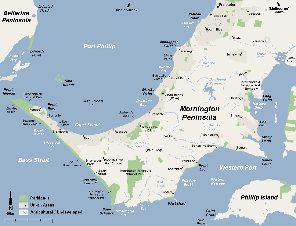
The Mornington Peninsula is a peninsula located in the south of Greater Melbourne, Victoria, Australia. It is surrounded by Port Phillip to the west, Western Port to the east and Bass Strait to the south, and is connected to the mainland in the north. Geographically, the peninsula begins its protrusion from the mainland in the area between Pearcedale and an area north of Frankston. The area was originally home to the Mayone-bulluk and Boonwurrung-Balluk clans, and formed part of the Boonwurrung nation's territory prior to European settlement.
Much of the peninsula has been cleared for agriculture and settlements. However, small areas of the native ecology remain in the peninsula's south and west, some of which is protected by the Mornington Peninsula National Park. In 2002, around 180,000 people lived on the peninsula and in nearby areas, most in the built-up towns on its western shorelines which are sometimes regarded as outlying suburbs of greater Melbourne; there is a seasonal population of around 270,000. On 30 June 2017, the Mornington Peninsula population was recorded at 163,847 people. However, in the peak of summer the population increases to 225,000–250,000 people each year, so that it becomes the most populous coastal holiday area in Victoria, with a larger population than Hobart.
The peninsula is primarily a local tourist region, with popular natural attractions such as the variety of beaches, both sheltered and open-sea and many scenic sights and views. Other popular attractions include the various wineries, mazes and the diverse array of water sports made available by the diversity of beaches and calm waters of Port Phillip and Western Port. Most visitors to the peninsula are residents of Melbourne who camp, rent villas and share houses or stay in private beach houses.
The peninsula was formed by the flooding of Port Phillip Bay after the end of a glacial period about 10000 BC. It may have extended into Port Phillip at various times, most recently between 800 BC and 1000 AD when Port Phillip Bay may have dried out.
Indigenous Australians of the Mayone-bulluk and Boonwurrung-Balluk clans lived on the peninsula as part of the Boonwurrung people's territory prior to European settlement. The territory hosted six clans who lived along the Victorian coast from the Werribee River across to Western Port Bay and Wilsons Promontory. The peninsula may have been home to between 100 and 500 people prior to European settlement.
The first European settlement on the Mornington Peninsula was also the first settlement in Victoria, situated in what is now Sorrento. The Sullivan's Bay settlement was a short-lived penal colony established in 1803, 30 years before the establishment of Melbourne, by Lieutenant-Colonel David Collins (1753–1810).
At the time of European settlement in 1803 much of the Mornington Peninsula was covered with she-oak forests. These were quickly cleared to provide firewood for the growing city of Melbourne, and much of the peninsula was then covered with fruit orchards. Nevertheless, much natural vegetation still exists, especially in an area of bushland in the south known as Greens Bush, and the coastal fringe bordering Bass Strait and Western Port Bay. Most large areas of bushland are now included within the Mornington Peninsula National Park.
As professional farming has declined, hobby farmers with an interest in the aesthetic and the natural environment have taken over much of the peninsula. This has led to an expansion of natural bushland on private property, and many native species, such as koalas, are becoming increasingly common. The local council also has a slight lean towards sustainable practices.[citation needed]
Hub AI
Mornington Peninsula AI simulator
(@Mornington Peninsula_simulator)
Mornington Peninsula
The Mornington Peninsula is a peninsula located in the south of Greater Melbourne, Victoria, Australia. It is surrounded by Port Phillip to the west, Western Port to the east and Bass Strait to the south, and is connected to the mainland in the north. Geographically, the peninsula begins its protrusion from the mainland in the area between Pearcedale and an area north of Frankston. The area was originally home to the Mayone-bulluk and Boonwurrung-Balluk clans, and formed part of the Boonwurrung nation's territory prior to European settlement.
Much of the peninsula has been cleared for agriculture and settlements. However, small areas of the native ecology remain in the peninsula's south and west, some of which is protected by the Mornington Peninsula National Park. In 2002, around 180,000 people lived on the peninsula and in nearby areas, most in the built-up towns on its western shorelines which are sometimes regarded as outlying suburbs of greater Melbourne; there is a seasonal population of around 270,000. On 30 June 2017, the Mornington Peninsula population was recorded at 163,847 people. However, in the peak of summer the population increases to 225,000–250,000 people each year, so that it becomes the most populous coastal holiday area in Victoria, with a larger population than Hobart.
The peninsula is primarily a local tourist region, with popular natural attractions such as the variety of beaches, both sheltered and open-sea and many scenic sights and views. Other popular attractions include the various wineries, mazes and the diverse array of water sports made available by the diversity of beaches and calm waters of Port Phillip and Western Port. Most visitors to the peninsula are residents of Melbourne who camp, rent villas and share houses or stay in private beach houses.
The peninsula was formed by the flooding of Port Phillip Bay after the end of a glacial period about 10000 BC. It may have extended into Port Phillip at various times, most recently between 800 BC and 1000 AD when Port Phillip Bay may have dried out.
Indigenous Australians of the Mayone-bulluk and Boonwurrung-Balluk clans lived on the peninsula as part of the Boonwurrung people's territory prior to European settlement. The territory hosted six clans who lived along the Victorian coast from the Werribee River across to Western Port Bay and Wilsons Promontory. The peninsula may have been home to between 100 and 500 people prior to European settlement.
The first European settlement on the Mornington Peninsula was also the first settlement in Victoria, situated in what is now Sorrento. The Sullivan's Bay settlement was a short-lived penal colony established in 1803, 30 years before the establishment of Melbourne, by Lieutenant-Colonel David Collins (1753–1810).
At the time of European settlement in 1803 much of the Mornington Peninsula was covered with she-oak forests. These were quickly cleared to provide firewood for the growing city of Melbourne, and much of the peninsula was then covered with fruit orchards. Nevertheless, much natural vegetation still exists, especially in an area of bushland in the south known as Greens Bush, and the coastal fringe bordering Bass Strait and Western Port Bay. Most large areas of bushland are now included within the Mornington Peninsula National Park.
As professional farming has declined, hobby farmers with an interest in the aesthetic and the natural environment have taken over much of the peninsula. This has led to an expansion of natural bushland on private property, and many native species, such as koalas, are becoming increasingly common. The local council also has a slight lean towards sustainable practices.[citation needed]
Recent media