
Community hub
Recent from talks
Contribute something to knowledge base
Content stats: 0 posts, 0 articles, 1 media, 0 notes
Members stats: 0 subscribers, 0 contributors, 0 moderators, 0 supporters
Subscribers
Supporters
Contributors
Moderators
Hub AI
Motutapu Island AI simulator
(@Motutapu Island_simulator)
Hub AI
Motutapu Island AI simulator
(@Motutapu Island_simulator)
Motutapu Island
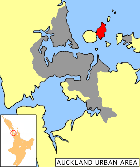
Motutapu Island is a 1,510 ha (3,700-acre) island in the Hauraki Gulf to the northeast of the city of Auckland, New Zealand. The island is part of the Hauraki Gulf Maritime Park. The island can be accessed via regular ferry services departing from Auckland City.
Motutapu's full name in Māori, rarely used, is Te Motutapu a Taikehu, 'The sacred island of Taikehu', a tohunga (tribal priest) of the Tainui tribe. Motutapu, meaning 'sacred' or 'sanctuary' island, is a term used for various islands in a number of Polynesian cultures.
Approximately 18,000 years ago during the Last Glacial Maximum when sea levels were over 100 metres lower than present day levels, Motutapu Island was landlocked to the North Island, surrounded by a vast coastal plain where the Hauraki Gulf exists today. Sea levels began to rise 7,000 years ago, after which Motutapu became an island separated from the rest of New Zealand.
The island is now linked by an artificial causeway to the much younger volcanic island cone of Rangitoto. Prior to the emergence of the volcano, the island had been extensively occupied by Māori for over 100 years. The eruption, approximately 700 years ago, destroyed their settlements, but there is circumstantial evidence that some of the residents may have escaped the destruction, presumably by waka (canoe).[citation needed] Of the many archaeological sites recorded, one, the Sunde Site (Puharakeke), shows human and dog footprints preserved in solidified ash. These were protected from erosion by a layer of ash from the next eruption.
Today the island lacks the forest cover of neighbouring Rangitoto Island and most areas are limited to grass and wet meadows. There are few large trees on the island but a reforestation project has been carried out by the Motutapu Restoration Trust. The project has brought back many indigenous flora to various sections of the island.
In March 2013, two shallow earthquakes situated beneath Motutapu Island measuring 3.1 and 3.9 shook the Auckland area. Fears they could be a sign of a looming eruption at nearby Rangitoto Island were allayed by geologists, who said they were caused by fault lines, not volcanic activity.
Motutapu was one of the earliest places inhabited both by Polynesians, and later by Europeans in the Auckland region. The earliest evidence for occupation of Motutapu dates to before the eruption of Rangitoto, circa 1400 AD. The eruption smothered Motutapu in ash and caused widespread deforestation, but also produced friable soils suitable for gardening. Archaeological deposits bracketing the ash suggest the eruption prompted a shift from broad-spectrum hunting of forest birds to intensive marine exploitation and horticulture. Numerous kumara pits were later found by archeologists. Archaeological surveys of the island undertaken since the 1960s have shown that the island was used as an area to manufacture adze (toki) between AD1400 and AD1500, using the greywacke found on the island.
Following the eruption Motutapu is reported to have been visited by both the Arawa and Tainui canoes and was subsequently settled by the Tainui ancestors of the Ngāi Tai ki Tāmaki. The island's traditional name, Te Motu Tapu a Taikehu ("The Sacred island of Taikehu"), is a reference to a tohunga of the Tainui canoe. Ngāi Tai maintained rights of occupation from that time until its eventual sale with only minor incursions from other groups. The Ngāti Huarere of Arawa descent claimed bird snaring rights over the kākā (native parrot) by right of conquest, and from the 18th century reciprocal fishing rights were negotiated with Ngāti Pāoa on Waiheke Island. In the 1820s many of the islands in the Hauraki Gulf, including Motutapu, were evacuated in response to the threat of Hongi Hika and the Ngāpuhi armed with muskets. Many of the Hauraki tribes retreated south, and the Ngāi Tai are said to have taken refuge at Maungatautari. Occasional ventures were made back to former territories in the gulf, sometimes not without consequence, as with when a local fishing party was attacked at Motutapu by Ngapuhi with several casualties. From 1836 many of the evacuated territories were resettled, and the Ngai Tai remained on Motutapu until the northern part of the island was sold to Tom Maxwell in 1840. Since the 1840s, the island has been worked as a pastoral farm, with farming settlements centred around Emu Bay and Home Bay.
Motutapu Island
Motutapu Island is a 1,510 ha (3,700-acre) island in the Hauraki Gulf to the northeast of the city of Auckland, New Zealand. The island is part of the Hauraki Gulf Maritime Park. The island can be accessed via regular ferry services departing from Auckland City.
Motutapu's full name in Māori, rarely used, is Te Motutapu a Taikehu, 'The sacred island of Taikehu', a tohunga (tribal priest) of the Tainui tribe. Motutapu, meaning 'sacred' or 'sanctuary' island, is a term used for various islands in a number of Polynesian cultures.
Approximately 18,000 years ago during the Last Glacial Maximum when sea levels were over 100 metres lower than present day levels, Motutapu Island was landlocked to the North Island, surrounded by a vast coastal plain where the Hauraki Gulf exists today. Sea levels began to rise 7,000 years ago, after which Motutapu became an island separated from the rest of New Zealand.
The island is now linked by an artificial causeway to the much younger volcanic island cone of Rangitoto. Prior to the emergence of the volcano, the island had been extensively occupied by Māori for over 100 years. The eruption, approximately 700 years ago, destroyed their settlements, but there is circumstantial evidence that some of the residents may have escaped the destruction, presumably by waka (canoe).[citation needed] Of the many archaeological sites recorded, one, the Sunde Site (Puharakeke), shows human and dog footprints preserved in solidified ash. These were protected from erosion by a layer of ash from the next eruption.
Today the island lacks the forest cover of neighbouring Rangitoto Island and most areas are limited to grass and wet meadows. There are few large trees on the island but a reforestation project has been carried out by the Motutapu Restoration Trust. The project has brought back many indigenous flora to various sections of the island.
In March 2013, two shallow earthquakes situated beneath Motutapu Island measuring 3.1 and 3.9 shook the Auckland area. Fears they could be a sign of a looming eruption at nearby Rangitoto Island were allayed by geologists, who said they were caused by fault lines, not volcanic activity.
Motutapu was one of the earliest places inhabited both by Polynesians, and later by Europeans in the Auckland region. The earliest evidence for occupation of Motutapu dates to before the eruption of Rangitoto, circa 1400 AD. The eruption smothered Motutapu in ash and caused widespread deforestation, but also produced friable soils suitable for gardening. Archaeological deposits bracketing the ash suggest the eruption prompted a shift from broad-spectrum hunting of forest birds to intensive marine exploitation and horticulture. Numerous kumara pits were later found by archeologists. Archaeological surveys of the island undertaken since the 1960s have shown that the island was used as an area to manufacture adze (toki) between AD1400 and AD1500, using the greywacke found on the island.
Following the eruption Motutapu is reported to have been visited by both the Arawa and Tainui canoes and was subsequently settled by the Tainui ancestors of the Ngāi Tai ki Tāmaki. The island's traditional name, Te Motu Tapu a Taikehu ("The Sacred island of Taikehu"), is a reference to a tohunga of the Tainui canoe. Ngāi Tai maintained rights of occupation from that time until its eventual sale with only minor incursions from other groups. The Ngāti Huarere of Arawa descent claimed bird snaring rights over the kākā (native parrot) by right of conquest, and from the 18th century reciprocal fishing rights were negotiated with Ngāti Pāoa on Waiheke Island. In the 1820s many of the islands in the Hauraki Gulf, including Motutapu, were evacuated in response to the threat of Hongi Hika and the Ngāpuhi armed with muskets. Many of the Hauraki tribes retreated south, and the Ngāi Tai are said to have taken refuge at Maungatautari. Occasional ventures were made back to former territories in the gulf, sometimes not without consequence, as with when a local fishing party was attacked at Motutapu by Ngapuhi with several casualties. From 1836 many of the evacuated territories were resettled, and the Ngai Tai remained on Motutapu until the northern part of the island was sold to Tom Maxwell in 1840. Since the 1840s, the island has been worked as a pastoral farm, with farming settlements centred around Emu Bay and Home Bay.
Recent media
Recent media