

Community hub
0 subscribers8 pages, 0 posts
Recent from talks
All channels
Be the first to start a discussion here.
Be the first to start a discussion here.
Be the first to start a discussion here.
Be the first to start a discussion here.
Contribute something
Welcome to the community hub built to collect knowledge and have discussions related to Mount Iriga.
Nothing was collected or created yet.
Mount Iriga
View on Wikipediafrom Wikipedia
Mount Iriga, also known as Mount Asog, is a dormant stratovolcano in the province of Camarines Sur, in the Philippines.
Key Information

.svg)
.svg)

It is a stratovolcano about a kilometer from Lake Buhi. It rises 1,196 m (3,924 ft) with a base diameter of 10 kilometres (6.2 mi).[1][2] It has a large crater formed due to a debris avalanche.
Mount Iriga, generally known for its phreatic explosions, erupted in 1628 and 1642.[2] After these eruptions, it remained dormant.
Gallery
[edit]-
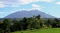 View from San Ramon, Iriga
 -
 View from San Jose, Iriga
 -
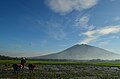
 View from Perpetual Help, Iriga
 -
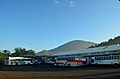 View from Iriga Central Terminal


See also
[edit]References
[edit]- ^ a b c "Iriga". Global Volcanism Program. Smithsonian Institution. Retrieved September 17, 2011.
- ^ a b "Mount Iriga". Philippine Institute of Volcanology and Seismology (PHIVOLCS). Archived from the original on September 1, 2011. Retrieved September 17, 2011.
External links
[edit] Media related to Mount Iriga at Wikimedia Commons
| Authority control databases: Geographic |
|---|
This article about a location in Bicol Region is a stub. You can help Wikipedia by expanding it. |
Mount Iriga
View on Grokipediafrom Grokipedia