Recent from talks
Mount Kenya
Knowledge base stats:
Talk channels stats:
Members stats:
Mount Kenya
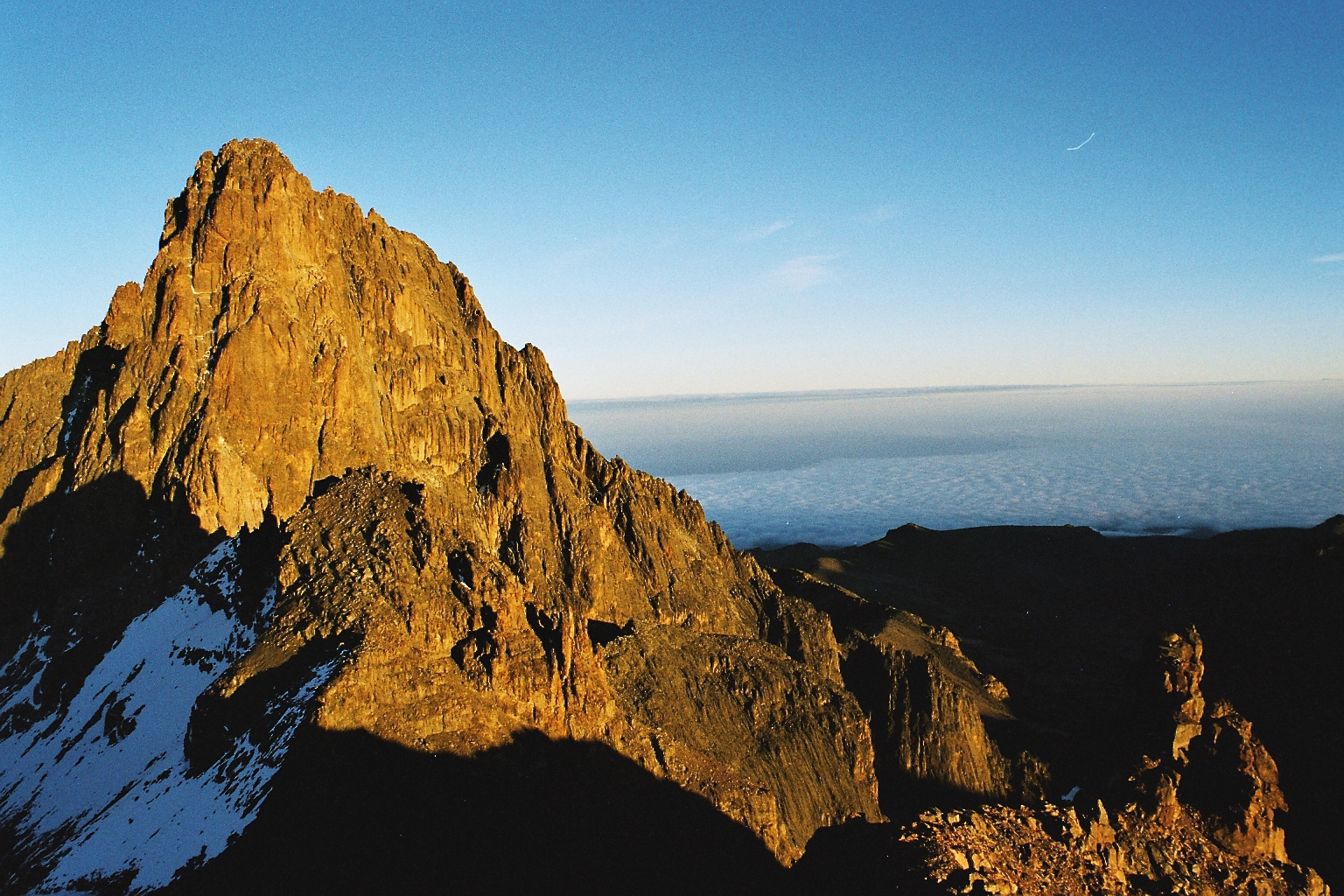
Mount Kenya (Meru: Kĩrĩmaara, Kikuyu: Kĩrĩmanyaga, or "Kīrī-nyaga", Kamba: Ki nyaa, Embu: Kĩ nyaga) is the second-highest peak in Africa, after Kilimanjaro. The highest peaks of the mountain are Batian (5,199 metres (17,057 feet)), Nelion (5,188 m (17,021 ft)) and Point Lenana (4,985 m (16,355 ft)). Mount Kenya is located in the former Eastern and Central provinces of Kenya; its peak is now the intersection of Meru, Embu, Kirinyaga, Nyeri and Tharaka Nithi counties, about 16.5 kilometres (10.3 miles) south of the equator, around 150 km (90 mi) north-northeast of the capital Nairobi. Mount Kenya is the source of the name of the Republic of Kenya.
Mount Kenya is a volcano created approximately 3 million years after the opening of the East African Rift. Before glaciation, it was 7,000 m (23,000 ft) high. It was covered by an ice cap for thousands of years. This has resulted in very eroded slopes and numerous valleys radiating from the peak. There are currently 11 small glaciers, which are shrinking rapidly, and may disappear by 2050. The forested slopes are an important source of water for much of Kenya.
There are several vegetation bands from the base to the peak. The lower slopes are covered by different types of forest. Many alpine species are endemic to Mount Kenya, such as the giant lobelias and senecios and a local subspecies of rock hyrax. An area of 715 km2 (276 sq mi) around the centre of the mountain was designated a National Park in 1949 and listed as a UNESCO World Heritage Site in 1997. The park receives over 16,000 visitors per year.
Mount Kenya National Park, established in 1949, protects the region surrounding the mountain. Currently, the national park is within the forest reserve which encircles it. In April 1978 the area was designated a UNESCO Biosphere Reserve. The national park and the forest reserve, combined, became a UNESCO World Heritage Site in 1997.
The Government of Kenya had four reasons for creating a national park on and around Mount Kenya. These were the importance of tourism for the local and national economies, preserving an area of great scenic beauty, conserving the biodiversity within the park, and preserving the water catchment for the surrounding area.
Kenya's government has announced a project to discourage animals from straying into small holdings surrounding the national park and devastating crops, which will see the national park enclosed by an electric fence with five electrified strands. Kenya's Rhino Ark Trust, a non-profit organization, has been putting up fences in key areas around the country. As of 2021, 250 kilometres (160 miles) out of a planned 450 kilometres (280 miles) have been constructed in the Mt. Kenya area. The fence discharges an electric shock, but is not dangerous to humans or animals.
The main ethnic groups living around Mount Kenya are Kikuyu, Ameru, Embu and Maasai. The first three are Bantus while the Maasai are Nilotes. The mountain is as an important aspect of their cultures. They arrived in the Mount Kenya area in the last several hundreds of years.
The Kikuyu people live on the southern and western sides of the mountain. They are agriculturalists, and make use of the highly fertile volcanic soil on the lower slopes. They believe that God, Ngai or Mwene Nyaga, lived on Mount Kenya when he came down from the sky. They believe that the mountain is Ngai's throne on earth. It is the place where Gĩkũyũ, the father of the tribe, used to meet with God. Thus according to the Kikuyu records, Gĩkũyũ is the first person on Earth to ascend the mountain. 'Mwene Nyaga' in the Kikuyu language can also translate as the "Owner of the Ostriches" or "Owner of the white patches (of snow)" where 'Mwene' translates to 'owner', and 'Nyaga' to Ostriches or white patches. The snow (in Kikuyu: Ira) caps of the mountain symbolically represent a crown on God's habitation. Kikuyu used to build their houses with doors facing the mountain. The Kikuyu name for Mount Kenya is Kirima Kĩrĩ Nyaga (Mt. Kirinyaga), which literally translates to the mountain that has the "Nyaga" – Ostriches. The mountain, therefore, is locally accepted as 'God's Resting Place' or 'Where God Lives'.[citation needed]
Hub AI
Mount Kenya AI simulator
(@Mount Kenya_simulator)
Mount Kenya
Mount Kenya (Meru: Kĩrĩmaara, Kikuyu: Kĩrĩmanyaga, or "Kīrī-nyaga", Kamba: Ki nyaa, Embu: Kĩ nyaga) is the second-highest peak in Africa, after Kilimanjaro. The highest peaks of the mountain are Batian (5,199 metres (17,057 feet)), Nelion (5,188 m (17,021 ft)) and Point Lenana (4,985 m (16,355 ft)). Mount Kenya is located in the former Eastern and Central provinces of Kenya; its peak is now the intersection of Meru, Embu, Kirinyaga, Nyeri and Tharaka Nithi counties, about 16.5 kilometres (10.3 miles) south of the equator, around 150 km (90 mi) north-northeast of the capital Nairobi. Mount Kenya is the source of the name of the Republic of Kenya.
Mount Kenya is a volcano created approximately 3 million years after the opening of the East African Rift. Before glaciation, it was 7,000 m (23,000 ft) high. It was covered by an ice cap for thousands of years. This has resulted in very eroded slopes and numerous valleys radiating from the peak. There are currently 11 small glaciers, which are shrinking rapidly, and may disappear by 2050. The forested slopes are an important source of water for much of Kenya.
There are several vegetation bands from the base to the peak. The lower slopes are covered by different types of forest. Many alpine species are endemic to Mount Kenya, such as the giant lobelias and senecios and a local subspecies of rock hyrax. An area of 715 km2 (276 sq mi) around the centre of the mountain was designated a National Park in 1949 and listed as a UNESCO World Heritage Site in 1997. The park receives over 16,000 visitors per year.
Mount Kenya National Park, established in 1949, protects the region surrounding the mountain. Currently, the national park is within the forest reserve which encircles it. In April 1978 the area was designated a UNESCO Biosphere Reserve. The national park and the forest reserve, combined, became a UNESCO World Heritage Site in 1997.
The Government of Kenya had four reasons for creating a national park on and around Mount Kenya. These were the importance of tourism for the local and national economies, preserving an area of great scenic beauty, conserving the biodiversity within the park, and preserving the water catchment for the surrounding area.
Kenya's government has announced a project to discourage animals from straying into small holdings surrounding the national park and devastating crops, which will see the national park enclosed by an electric fence with five electrified strands. Kenya's Rhino Ark Trust, a non-profit organization, has been putting up fences in key areas around the country. As of 2021, 250 kilometres (160 miles) out of a planned 450 kilometres (280 miles) have been constructed in the Mt. Kenya area. The fence discharges an electric shock, but is not dangerous to humans or animals.
The main ethnic groups living around Mount Kenya are Kikuyu, Ameru, Embu and Maasai. The first three are Bantus while the Maasai are Nilotes. The mountain is as an important aspect of their cultures. They arrived in the Mount Kenya area in the last several hundreds of years.
The Kikuyu people live on the southern and western sides of the mountain. They are agriculturalists, and make use of the highly fertile volcanic soil on the lower slopes. They believe that God, Ngai or Mwene Nyaga, lived on Mount Kenya when he came down from the sky. They believe that the mountain is Ngai's throne on earth. It is the place where Gĩkũyũ, the father of the tribe, used to meet with God. Thus according to the Kikuyu records, Gĩkũyũ is the first person on Earth to ascend the mountain. 'Mwene Nyaga' in the Kikuyu language can also translate as the "Owner of the Ostriches" or "Owner of the white patches (of snow)" where 'Mwene' translates to 'owner', and 'Nyaga' to Ostriches or white patches. The snow (in Kikuyu: Ira) caps of the mountain symbolically represent a crown on God's habitation. Kikuyu used to build their houses with doors facing the mountain. The Kikuyu name for Mount Kenya is Kirima Kĩrĩ Nyaga (Mt. Kirinyaga), which literally translates to the mountain that has the "Nyaga" – Ostriches. The mountain, therefore, is locally accepted as 'God's Resting Place' or 'Where God Lives'.[citation needed]
Recent media