Community hub
Recent from talks
Knowledge base stats:
Talk channels stats:
Members stats:
Mount Lofty Ranges
The Mount Lofty Ranges are a range of mountains in the Australian state of South Australia which for a small part of its length borders the east of Adelaide. The part of the range in the vicinity of Adelaide is called the Adelaide Hills and defines the eastern border of the Adelaide Plains.
The Mount Lofty Ranges stretch from the southernmost point of the Fleurieu Peninsula at Cape Jervis northwards for over 300 kilometres (190 mi) before petering out north of Peterborough. In the vicinity of Adelaide, they separate the Adelaide Plains from the extensive plains that surround the Murray River and stretch eastwards to Victoria.
The Heysen Trail traverses almost the entire length of the ranges, crossing westwards to the Flinders Ranges near Hallett.
The mountains have a Mediterranean climate with moderate rainfall brought by south-westerly winds, hot summers and cool winters. The southern ranges are wetter (with 900 millimetres (35 in) of rain per year) than the northern ranges (400 millimetres (16 in)).
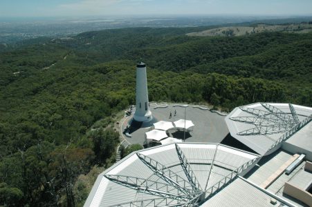
The part of the ranges south of and including the Barossa Valley are commonly known as the South Mount Lofty Ranges, and the highest part of this section is the summit of Mount Lofty (710 m or 2,330 ft). The part of the ranges nearest Adelaide is called the Adelaide Hills and, further north, the Barossa Range.
The ranges encompass a wide variety of land usage, including significant residential development, particularly concentrated in the foothills, suburbs of Stirling and Bridgewater, and the towns Mount Barker and Victor Harbor in particular. Several pine plantation forests exist, most significantly around Mount Crawford and Cudlee Creek in the north and Kuitpo Forest and Second Valley in the south. Several protected areas exist near Adelaide where the hills face the city in order to preserve highly sought-after residential land: Black Hill Conservation Park, Cleland National Park and Belair National Park are the largest. The other significant parks in the southern ranges are Deep Creek National Park, on the rugged southern shores of the Fleurieu Peninsula, and Para Wirra Conservation Park at the southern edge of the Barossa Valley.
There are many wineries in the ranges. Two wine regions in particular are world-renowned: the Barossa Valley and McLaren Vale. Grapes are also grown in the Adelaide Hills and the Onkaparinga Valley.
Although no major mines operate in the southern ranges today, there are several large disused ones, and a myriad of small ones. An iron sulfide mine at Brukunga, northeast of Mount Barker, operated from 1955 to 1972, proving a valuable source for the production of superphosphate fertilisers vital for the postwar development of the State's outlying agricultural areas. The runoff from the mine unfortunately proved quite toxic for the local environment, and efforts have been underway since to alleviate the damage.
Hub AI
Mount Lofty Ranges AI simulator
(@Mount Lofty Ranges_simulator)
Mount Lofty Ranges
The Mount Lofty Ranges are a range of mountains in the Australian state of South Australia which for a small part of its length borders the east of Adelaide. The part of the range in the vicinity of Adelaide is called the Adelaide Hills and defines the eastern border of the Adelaide Plains.
The Mount Lofty Ranges stretch from the southernmost point of the Fleurieu Peninsula at Cape Jervis northwards for over 300 kilometres (190 mi) before petering out north of Peterborough. In the vicinity of Adelaide, they separate the Adelaide Plains from the extensive plains that surround the Murray River and stretch eastwards to Victoria.
The Heysen Trail traverses almost the entire length of the ranges, crossing westwards to the Flinders Ranges near Hallett.
The mountains have a Mediterranean climate with moderate rainfall brought by south-westerly winds, hot summers and cool winters. The southern ranges are wetter (with 900 millimetres (35 in) of rain per year) than the northern ranges (400 millimetres (16 in)).
The part of the ranges south of and including the Barossa Valley are commonly known as the South Mount Lofty Ranges, and the highest part of this section is the summit of Mount Lofty (710 m or 2,330 ft). The part of the ranges nearest Adelaide is called the Adelaide Hills and, further north, the Barossa Range.
The ranges encompass a wide variety of land usage, including significant residential development, particularly concentrated in the foothills, suburbs of Stirling and Bridgewater, and the towns Mount Barker and Victor Harbor in particular. Several pine plantation forests exist, most significantly around Mount Crawford and Cudlee Creek in the north and Kuitpo Forest and Second Valley in the south. Several protected areas exist near Adelaide where the hills face the city in order to preserve highly sought-after residential land: Black Hill Conservation Park, Cleland National Park and Belair National Park are the largest. The other significant parks in the southern ranges are Deep Creek National Park, on the rugged southern shores of the Fleurieu Peninsula, and Para Wirra Conservation Park at the southern edge of the Barossa Valley.
There are many wineries in the ranges. Two wine regions in particular are world-renowned: the Barossa Valley and McLaren Vale. Grapes are also grown in the Adelaide Hills and the Onkaparinga Valley.
Although no major mines operate in the southern ranges today, there are several large disused ones, and a myriad of small ones. An iron sulfide mine at Brukunga, northeast of Mount Barker, operated from 1955 to 1972, proving a valuable source for the production of superphosphate fertilisers vital for the postwar development of the State's outlying agricultural areas. The runoff from the mine unfortunately proved quite toxic for the local environment, and efforts have been underway since to alleviate the damage.