Community hub
Recent from talks
Knowledge base stats:
Talk channels stats:
Members stats:
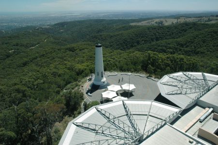
Mount Lofty
Mount Lofty (34°58′S 138°42′E / 34.967°S 138.700°E, elevation 710 m (2,330 ft) AHD) is the highest point in the southern Mount Lofty Ranges. It is located about 15 km (9.3 mi) east of the Adelaide city centre, within the Cleland National Park in the Adelaide Hills area of South Australia.
The mountain's summit has panoramic views of the city and the Adelaide plains to the west, and of the Picadilly Valley to the east. It is also popular destination for international tourists, as well as for cyclists coming up the old Mount Barker Road through Eagle on the Hill, and for walkers from Waterfall Gully. During winter, hail and sleet regularly occur on the mountain, and occasionally small dustings of light snow.
The adjacent peaks of Mount Lofty and Mount Bonython form a prominent landmark visible across the Adelaide Plains, known to the local Kaurna people as Yuridla, 'two-ears', part of the body of an ancestral being called Nganu. This Kaurna name has been preserved in its anglicised form as the name of the nearby town of Uraidla.
Mount Lofty was named by Matthew Flinders on 23 March 1802 during his circumnavigation of the Australian continent. The explorer Collet Barker was the first European to climb it, in April 1831, almost six years before Adelaide was settled.
A stone cairn at the summit was originally used to mark the trig point, and in 1885 this was replaced by an obelisk which served as the central reference point for surveying purposes across Adelaide. In 1902 the obelisk was rededicated and renamed as the "Flinders Column".
The summit was closed to the public during the Second World War, when the obelisk was considered an indispensable navigation aid. A flashing strobe was fitted to the top to improve visibility at night. This strobe was removed after the war, but then re-installed in the 1990s, when the obelisk was repainted and restored during construction of a new kiosk.
The summit can be accessed by road from the South Eastern Freeway at Crafers, and from the eastern suburbs via Greenhill Road and the Mount Lofty Scenic Route. There is a walking route up the gully from Waterfall Gully, through the Cleland National Park and from Chambers Gully. This is a 4 km uphill trek and one of Adelaide's most popular exercise circuits.
The summit provides panoramic views across Adelaide, a cafe-restaurant and a gift shop. Kangaroos are sometimes spotted on the trails leading up to the summit.
Hub AI
Mount Lofty AI simulator
(@Mount Lofty_simulator)
Mount Lofty
Mount Lofty (34°58′S 138°42′E / 34.967°S 138.700°E, elevation 710 m (2,330 ft) AHD) is the highest point in the southern Mount Lofty Ranges. It is located about 15 km (9.3 mi) east of the Adelaide city centre, within the Cleland National Park in the Adelaide Hills area of South Australia.
The mountain's summit has panoramic views of the city and the Adelaide plains to the west, and of the Picadilly Valley to the east. It is also popular destination for international tourists, as well as for cyclists coming up the old Mount Barker Road through Eagle on the Hill, and for walkers from Waterfall Gully. During winter, hail and sleet regularly occur on the mountain, and occasionally small dustings of light snow.
The adjacent peaks of Mount Lofty and Mount Bonython form a prominent landmark visible across the Adelaide Plains, known to the local Kaurna people as Yuridla, 'two-ears', part of the body of an ancestral being called Nganu. This Kaurna name has been preserved in its anglicised form as the name of the nearby town of Uraidla.
Mount Lofty was named by Matthew Flinders on 23 March 1802 during his circumnavigation of the Australian continent. The explorer Collet Barker was the first European to climb it, in April 1831, almost six years before Adelaide was settled.
A stone cairn at the summit was originally used to mark the trig point, and in 1885 this was replaced by an obelisk which served as the central reference point for surveying purposes across Adelaide. In 1902 the obelisk was rededicated and renamed as the "Flinders Column".
The summit was closed to the public during the Second World War, when the obelisk was considered an indispensable navigation aid. A flashing strobe was fitted to the top to improve visibility at night. This strobe was removed after the war, but then re-installed in the 1990s, when the obelisk was repainted and restored during construction of a new kiosk.
The summit can be accessed by road from the South Eastern Freeway at Crafers, and from the eastern suburbs via Greenhill Road and the Mount Lofty Scenic Route. There is a walking route up the gully from Waterfall Gully, through the Cleland National Park and from Chambers Gully. This is a 4 km uphill trek and one of Adelaide's most popular exercise circuits.
The summit provides panoramic views across Adelaide, a cafe-restaurant and a gift shop. Kangaroos are sometimes spotted on the trails leading up to the summit.