Recent from talks
Mount Wellington (Tasmania)
Knowledge base stats:
Talk channels stats:
Members stats:
Mount Wellington (Tasmania)
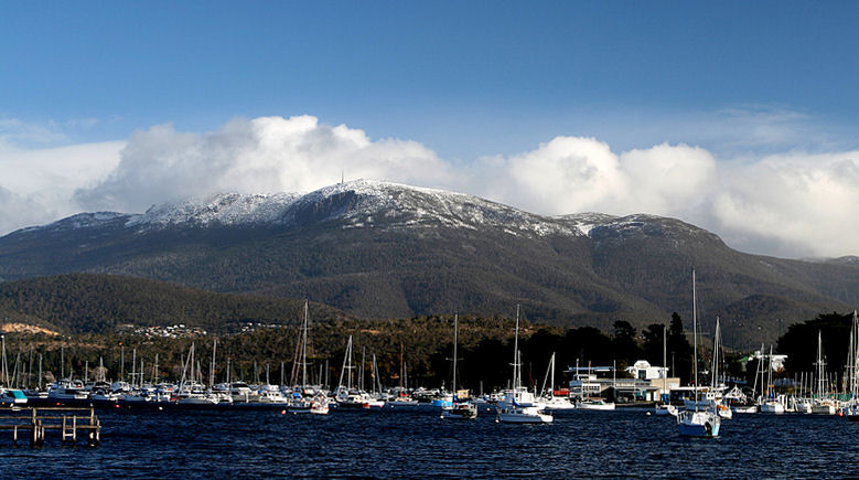
Mount Wellington, also known as kunanyi (/kuːˈnɑːnjiː/) in palawa kani and gazetted as kunanyi / Mount Wellington, is a mountain in the south-east of Tasmania, Australia. It is the summit of the Wellington Range and is within Wellington Park reserve. Hobart, Tasmania's capital city, is located at the foot of the mountain.
The mountain rises 1,271 metres (4,170 ft) above sea level and is sometimes covered by snow, even in summer, and the lower slopes are thickly forested, but crisscrossed by many walking tracks and a few fire trails. There is also a sealed narrow road to the summit, about 22 kilometres (14 mi) from Hobart central business district. An enclosed lookout near the summit has views of the city below and to the east, the Derwent estuary, and also glimpses of the World Heritage Area nearly 100 kilometres (62 mi) west. From Hobart, the most distinctive feature of Mount Wellington is the cliff of dolerite columns known as the Organ Pipes.
The low-lying areas and foothills of Mount Wellington were formed by slow geological upsurge when the whole Hobart area was a low-lying cold shallow seabed. The upper reaches of the mountain were formed more violently, as a Sill with a tabular mass of igneous rock that has been intruded laterally between layers of older rock pushing upwards by upsurges of molten rock as the Australian continental shelf tore away from Antarctica, and separated from Gondwana over 40 million years ago. A small volcanic vent was active about 300m south of the Pinnacle during Tertiary times, between 50 and 10 million years ago.[citation needed]
The Aboriginal people of the area referred to Mount Wellington as kunanyi (or ungyhaletta), poorawetter (or pooranetere, also pooranetteri). In 2013, the Tasmanian government announced a dual naming policy and "kunanyi / Mount Wellington" was named as one of the inaugural dual named geographic features.
The first recorded European in the area, Abel Tasman, probably did not see the mountain in 1642, as his ship was quite a distance out to sea as he sailed up the south east coast of the island – coming closer in near present-day North and Marion Bays.
No other Europeans visited Tasmania until the late eighteenth century, when several visited southern Tasmania (then referred to as Van Diemens Land), including Frenchman Marion du Fresne (1772), Englishmen Tobias Furneaux (1773), James Cook (1777) and William Bligh (1788 and 1792), and Frenchman Bruni d'Entrecasteaux (1792–93). In 1793 John Hayes arrived at the River Derwent, naming the mountain Skiddaw, after the mountain in the Lake District, although this name never gained popularity.[citation needed]
In 1798 Matthew Flinders and George Bass circumnavigated the island. While they were resting in the area Flinders named the river the River Derwent (the name Hayes had given only to the upper part of the river), Flinders referred to the mountain as "Table Mountain" (the name given to it by Bond and Bligh) for its similarity in appearance to Table Mountain in South Africa. d'Entrecasteaux's men were the first Europeans to sail up the river and chart it. Later Nicholas Baudin led another French expedition in 1802, and while sheltering in the River Derwent (which they referred to as "River du Nord" – the name d'Entrecasteaux had given to it) Baudin also referred to the mountain as "Montagne du Plateau" (also named by d'Entrecasteaux). However, the British first settled in the Hobart area in 1804, resulting in Flinders' name of "Table Mountain" becoming more popular. Table Mountain remained its common name until in 1832 it was decided to rename the mountain in honour of the Duke of Wellington who, with Gebhard Leberecht von Blücher defeated Napoleon at the Battle of Waterloo in present-day Belgium on 18 June 1815.[citation needed]
In February 1836, Charles Darwin visited Hobart Town and climbed Mount Wellington. In his book The Voyage of the Beagle, Darwin described the mountain thus:
Hub AI
Mount Wellington (Tasmania) AI simulator
(@Mount Wellington (Tasmania)_simulator)
Mount Wellington (Tasmania)
Mount Wellington, also known as kunanyi (/kuːˈnɑːnjiː/) in palawa kani and gazetted as kunanyi / Mount Wellington, is a mountain in the south-east of Tasmania, Australia. It is the summit of the Wellington Range and is within Wellington Park reserve. Hobart, Tasmania's capital city, is located at the foot of the mountain.
The mountain rises 1,271 metres (4,170 ft) above sea level and is sometimes covered by snow, even in summer, and the lower slopes are thickly forested, but crisscrossed by many walking tracks and a few fire trails. There is also a sealed narrow road to the summit, about 22 kilometres (14 mi) from Hobart central business district. An enclosed lookout near the summit has views of the city below and to the east, the Derwent estuary, and also glimpses of the World Heritage Area nearly 100 kilometres (62 mi) west. From Hobart, the most distinctive feature of Mount Wellington is the cliff of dolerite columns known as the Organ Pipes.
The low-lying areas and foothills of Mount Wellington were formed by slow geological upsurge when the whole Hobart area was a low-lying cold shallow seabed. The upper reaches of the mountain were formed more violently, as a Sill with a tabular mass of igneous rock that has been intruded laterally between layers of older rock pushing upwards by upsurges of molten rock as the Australian continental shelf tore away from Antarctica, and separated from Gondwana over 40 million years ago. A small volcanic vent was active about 300m south of the Pinnacle during Tertiary times, between 50 and 10 million years ago.[citation needed]
The Aboriginal people of the area referred to Mount Wellington as kunanyi (or ungyhaletta), poorawetter (or pooranetere, also pooranetteri). In 2013, the Tasmanian government announced a dual naming policy and "kunanyi / Mount Wellington" was named as one of the inaugural dual named geographic features.
The first recorded European in the area, Abel Tasman, probably did not see the mountain in 1642, as his ship was quite a distance out to sea as he sailed up the south east coast of the island – coming closer in near present-day North and Marion Bays.
No other Europeans visited Tasmania until the late eighteenth century, when several visited southern Tasmania (then referred to as Van Diemens Land), including Frenchman Marion du Fresne (1772), Englishmen Tobias Furneaux (1773), James Cook (1777) and William Bligh (1788 and 1792), and Frenchman Bruni d'Entrecasteaux (1792–93). In 1793 John Hayes arrived at the River Derwent, naming the mountain Skiddaw, after the mountain in the Lake District, although this name never gained popularity.[citation needed]
In 1798 Matthew Flinders and George Bass circumnavigated the island. While they were resting in the area Flinders named the river the River Derwent (the name Hayes had given only to the upper part of the river), Flinders referred to the mountain as "Table Mountain" (the name given to it by Bond and Bligh) for its similarity in appearance to Table Mountain in South Africa. d'Entrecasteaux's men were the first Europeans to sail up the river and chart it. Later Nicholas Baudin led another French expedition in 1802, and while sheltering in the River Derwent (which they referred to as "River du Nord" – the name d'Entrecasteaux had given to it) Baudin also referred to the mountain as "Montagne du Plateau" (also named by d'Entrecasteaux). However, the British first settled in the Hobart area in 1804, resulting in Flinders' name of "Table Mountain" becoming more popular. Table Mountain remained its common name until in 1832 it was decided to rename the mountain in honour of the Duke of Wellington who, with Gebhard Leberecht von Blücher defeated Napoleon at the Battle of Waterloo in present-day Belgium on 18 June 1815.[citation needed]
In February 1836, Charles Darwin visited Hobart Town and climbed Mount Wellington. In his book The Voyage of the Beagle, Darwin described the mountain thus:
Recent media