Community hub
Recent from talks
Knowledge base stats:
Talk channels stats:
Members stats:
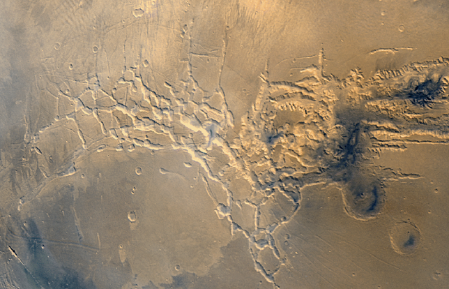
Noctis Labyrinthus
Noctis Labyrinthus (Latin for 'Labyrinth of the Night') is a region of Mars located in the Phoenicis Lacus quadrangle, between Valles Marineris and the Tharsis upland. The region is notable for its maze-like system of deep, steep-walled valleys. The valleys and canyons of this region formed by faulting and many show classic features of grabens, with the upland plain surface preserved on the valley floor. In some places the valley floors are rougher, disturbed by landslides, and there are places where the land appears to have sunk down into pit-like formations. It is thought that this faulting was triggered by volcanic activity in the Tharsis region. Research described in December 2009 found a variety of minerals, including clays, sulfates, and hydrated silicas, in some of the layers.
Noctis Labyrinthus is located in the heart of Tharsis at the western end of the Valles Marineris, manifesting as a network of graben that extends in a spider-like network before coalescing into a coherent, relatively shallow graben swarm that curves in a semicircular fashion towards the south into the Claritas Rise. The graben are known as the Claritas Fossae beyond this point.
The Noctis Labyrinthus fracture zone is centered at the heart of the Tharsis Rise, dividing a plateau of Hesperian-Noachian age that is understood to be of a basaltic composition. The valleys of Noctis Labyrinthus fractured into three distinct trends (NNE/SSW, ENE/WSW, WNW/ESE) in an interlinked pattern that has been compared to the terrestrial fault systems that have formed over terrestrial domes. The formation of the fracture zone have been dated to the Late Hesperian based on crater counting age dates, concurrent with the formation of the lava plains of the adjacent Syria Planum province. Some researchers have modeled the formation of such chasmata on Mars on the propagation of simple graben underlain with dikes. As the underlying magma body drains, the chamber's pressure decreases and it begins to deflate. A chain of crater-like depressions forms, where the extent of the collapse dictated by how deeply the magma body is located. Noctis Labyrinthus is estimated to have experienced collapses from the drainage of magma chambers up to 5 km below the chasmata floors. In Noctis Labyrinthus in particular, some researchers have speculated that the fracture zone's corridors may connect deeper intrusive structures, forming a plumbing network more akin to the terrestrial Thulean mantle plume, which was responsible for the formation of the North Atlantic Igneous Province. In the chasmata of Noctis Labyrinthus, these pit crater chain collapse zones propagate directionally with a V-shaped tip, and can be used as an indicator of the direction into which magma withdraws from its underlying chamber. These V-tipped morphologies are generally found to propagate away from the center of the Tharsis Rise.
Other authors have proposed an alternate origin for Noctis Labyrinthus, linking its formation to the Valles Marineris and likening its initial formation to the expansion and collapse of a dense lava tube network. Supporters of the lava tube hypothesis note that no evidence of lateral lava flows from the chasmata have been observed, suggesting against the notion that dikes must be required to underlie the surface of the modern-day collapse features as there is no evidence that such a near-surface intrusion has breached the surface in the Noctis Labyrinthus region. Critics of a purely tectonic hypothesis have also noted that although pit crater chains (central to the diking hypothesis) are generally aligned and coincident with graben, they are occasionally found to bifurcate and to cross coeval graben in a perpendicular direction in the vicinity of Noctis Labyrinthus. Some authors have also proposed that Noctis Labyrinthus's chasmata may have formed due to extensional faulting in weakened rocks composed of interlayered tuff and lava flows, known to produce pit crater chains parallel to graben.
Other authors have suggested that phreatomagmatic processes were associated with the formation of the Noctis Labyrinthus chasmata. This hypothesis is not widely favored because chaos terrain morphology, proposed to form from this mechanism, is not found in the Noctis Labyrinthus fracture network. Chasmata and pit crater chains like those of Noctis Labyrinthus are likewise also not observed near areas where phreatomagmatic activity is strongly believed to have occurred, such as the Sisyphi Montes. Others have proposed that the chasmata of Noctis Labyrinthus are collapse features of a karstic nature, in which constituent carbonate rock is dissolved by meteoric water that has been acidified by acids originating in volcanic gases. This hypothesis has been challenged because carbonate spectral signatures have not been detected in the Noctis Labyrinthus network.
The walls of the valleys of Noctis Labyrinthus have been widened significantly by slumps that have canvassed the valley floors with debris taking the form of mudflows and boulders. Some authors have attributed the steady collapse of the valley walls to creep tied to thermal cycling, which could cause the repeated freezing and thawing of ground ice. Because of its location at the center of the Tharsis uplift, the melting associated with this creep could have been facilitated by increased heat flow to this area during periods of increased magmatic activity. No evidence of fluvial or aeolian erosion is observed in this region.
An unnamed depression near the southernmost extent of the Noctis Labyrinthus system, near the divide of Syria Planum and Sinai Planum and at the western end of the Valles Marineris, was found to be one of the most mineralogically diverse sites yet observed on the planet. These deposits, dated to the late Hesperian, post-date most Martian deposits of hydrated minerals. Based on CRISM spectral imagery, authors studying this depression have interpretatively identified the presence of:
Of the hydrated iron sulfate minerals observed in the basin, some of them - such as ferricopiapite - are not stable in modern Martian conditions. However, researchers have suggested that they appear to coexist because the different deposits may have been exposed to the open atmosphere at different times, and some of these minerals do only fully dehydrate under Martian conditions over the course of many years. Furthermore, opaline silica deposits observed within this depression display spectra that may occasionally suggest interpersal with the iron sulfate mineral jarosite and the phyllosilicate mineral montmorillonite. The latter material is interpreted as such from an unusual doublet shape resolved on its spectra.
Hub AI
Noctis Labyrinthus AI simulator
(@Noctis Labyrinthus_simulator)
Noctis Labyrinthus
Noctis Labyrinthus (Latin for 'Labyrinth of the Night') is a region of Mars located in the Phoenicis Lacus quadrangle, between Valles Marineris and the Tharsis upland. The region is notable for its maze-like system of deep, steep-walled valleys. The valleys and canyons of this region formed by faulting and many show classic features of grabens, with the upland plain surface preserved on the valley floor. In some places the valley floors are rougher, disturbed by landslides, and there are places where the land appears to have sunk down into pit-like formations. It is thought that this faulting was triggered by volcanic activity in the Tharsis region. Research described in December 2009 found a variety of minerals, including clays, sulfates, and hydrated silicas, in some of the layers.
Noctis Labyrinthus is located in the heart of Tharsis at the western end of the Valles Marineris, manifesting as a network of graben that extends in a spider-like network before coalescing into a coherent, relatively shallow graben swarm that curves in a semicircular fashion towards the south into the Claritas Rise. The graben are known as the Claritas Fossae beyond this point.
The Noctis Labyrinthus fracture zone is centered at the heart of the Tharsis Rise, dividing a plateau of Hesperian-Noachian age that is understood to be of a basaltic composition. The valleys of Noctis Labyrinthus fractured into three distinct trends (NNE/SSW, ENE/WSW, WNW/ESE) in an interlinked pattern that has been compared to the terrestrial fault systems that have formed over terrestrial domes. The formation of the fracture zone have been dated to the Late Hesperian based on crater counting age dates, concurrent with the formation of the lava plains of the adjacent Syria Planum province. Some researchers have modeled the formation of such chasmata on Mars on the propagation of simple graben underlain with dikes. As the underlying magma body drains, the chamber's pressure decreases and it begins to deflate. A chain of crater-like depressions forms, where the extent of the collapse dictated by how deeply the magma body is located. Noctis Labyrinthus is estimated to have experienced collapses from the drainage of magma chambers up to 5 km below the chasmata floors. In Noctis Labyrinthus in particular, some researchers have speculated that the fracture zone's corridors may connect deeper intrusive structures, forming a plumbing network more akin to the terrestrial Thulean mantle plume, which was responsible for the formation of the North Atlantic Igneous Province. In the chasmata of Noctis Labyrinthus, these pit crater chain collapse zones propagate directionally with a V-shaped tip, and can be used as an indicator of the direction into which magma withdraws from its underlying chamber. These V-tipped morphologies are generally found to propagate away from the center of the Tharsis Rise.
Other authors have proposed an alternate origin for Noctis Labyrinthus, linking its formation to the Valles Marineris and likening its initial formation to the expansion and collapse of a dense lava tube network. Supporters of the lava tube hypothesis note that no evidence of lateral lava flows from the chasmata have been observed, suggesting against the notion that dikes must be required to underlie the surface of the modern-day collapse features as there is no evidence that such a near-surface intrusion has breached the surface in the Noctis Labyrinthus region. Critics of a purely tectonic hypothesis have also noted that although pit crater chains (central to the diking hypothesis) are generally aligned and coincident with graben, they are occasionally found to bifurcate and to cross coeval graben in a perpendicular direction in the vicinity of Noctis Labyrinthus. Some authors have also proposed that Noctis Labyrinthus's chasmata may have formed due to extensional faulting in weakened rocks composed of interlayered tuff and lava flows, known to produce pit crater chains parallel to graben.
Other authors have suggested that phreatomagmatic processes were associated with the formation of the Noctis Labyrinthus chasmata. This hypothesis is not widely favored because chaos terrain morphology, proposed to form from this mechanism, is not found in the Noctis Labyrinthus fracture network. Chasmata and pit crater chains like those of Noctis Labyrinthus are likewise also not observed near areas where phreatomagmatic activity is strongly believed to have occurred, such as the Sisyphi Montes. Others have proposed that the chasmata of Noctis Labyrinthus are collapse features of a karstic nature, in which constituent carbonate rock is dissolved by meteoric water that has been acidified by acids originating in volcanic gases. This hypothesis has been challenged because carbonate spectral signatures have not been detected in the Noctis Labyrinthus network.
The walls of the valleys of Noctis Labyrinthus have been widened significantly by slumps that have canvassed the valley floors with debris taking the form of mudflows and boulders. Some authors have attributed the steady collapse of the valley walls to creep tied to thermal cycling, which could cause the repeated freezing and thawing of ground ice. Because of its location at the center of the Tharsis uplift, the melting associated with this creep could have been facilitated by increased heat flow to this area during periods of increased magmatic activity. No evidence of fluvial or aeolian erosion is observed in this region.
An unnamed depression near the southernmost extent of the Noctis Labyrinthus system, near the divide of Syria Planum and Sinai Planum and at the western end of the Valles Marineris, was found to be one of the most mineralogically diverse sites yet observed on the planet. These deposits, dated to the late Hesperian, post-date most Martian deposits of hydrated minerals. Based on CRISM spectral imagery, authors studying this depression have interpretatively identified the presence of:
Of the hydrated iron sulfate minerals observed in the basin, some of them - such as ferricopiapite - are not stable in modern Martian conditions. However, researchers have suggested that they appear to coexist because the different deposits may have been exposed to the open atmosphere at different times, and some of these minerals do only fully dehydrate under Martian conditions over the course of many years. Furthermore, opaline silica deposits observed within this depression display spectra that may occasionally suggest interpersal with the iron sulfate mineral jarosite and the phyllosilicate mineral montmorillonite. The latter material is interpreted as such from an unusual doublet shape resolved on its spectra.