Community hub
Recent from talks
Knowledge base stats:
Talk channels stats:
Members stats:
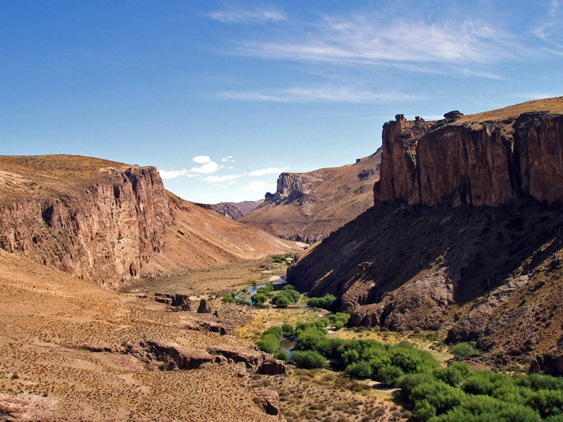
Patagonian Desert
The Patagonian Desert, also known as the Patagonian Steppe, is the largest desert in Argentina and is the eighth-largest desert in the world by area, occupying approx. 673,000 square kilometres (260,000 mi2). It is located primarily in Argentina and is bounded by the Andes, to its west, and the Atlantic Ocean to its east, in the region of Patagonia, southern Argentina and areas of Chile. To the north the desert grades into the Cuyo Region and the Monte. The central parts of the steppe are dominated by shrubby and herbaceous plant species albeit to the west, where precipitation is higher, bushes are replaced by grasses. Topographically the deserts consist of alternating tablelands and massifs dissected by river valleys and canyons. The more western parts of the steppe host lakes of glacial origin and grades into barren mountains or cold temperate forests along valleys.
Inhabited by hunter-gatherers since Pre-Hispanic times, the desert faced migration in the 19th century of Argentines, Welsh, and other European peoples, transforming it from a conflictive borderland zone to an integral part of Argentina, with cattle, sheep and horse husbandry being the primary land uses.
The Patagonian Desert has existed since the Middle Miocene (14–12 million years ago) and came into existence as the Andes rose to the west.
The Patagonian Desert is the largest desert south of the 40° parallel and is a large cold winter desert, where the temperature rarely exceeds 12 °C and averages just 3 °C. The region experiences about seven months of winter and five months of summer. Frost is not uncommon in the desert but, due to the very dry condition year round, snow is rare. The Andes, to the desert's west, are the primary reason for the Patagonian desert status as they inhibit the westerly flow of moisture from the southern Pacific from reaching inland. This creates a rain shadow that accounts for the formation of the desert and is why, despite approximately half of the desert being only about 200 miles from the ocean, such a large desert is found in the region. The cold Falkland Current off the Atlantic coast of South America also contributes to the area's aridity.
Different climates can be distinguished: the coast north of the 45th parallel is much milder because of the warm currents from Brazil, and the entire northern half of the region is significantly warmer in the summer, when sunny weather predominates. Daily temperatures in the summer reach 31 °C in the Rio Colorado region, a general 26 °C to 29 °C in the northern coast, and 24 °C to 28 °C in the northern plain, with nights around 12 °C to 15 °C in the coast and between 7 °C and 10 °C in the steppe. In the south, summer temperatures decrease from 22 °C to only 16 °C along the coast, and from 24 °C to 17 °C along the steppes, while nights go from 8 °C to 11 °C on the coast, and from 6 °C to 10 °C in the steppe.
During the winter, the proximity to the coast and the altitude are the main factors: while northern coastal areas have mild winters, from 2 °C at night to about 11 °C during the day, southern Santa Cruz ranges from -2 °C to 5 °C, and Tierra del Fuego, from -3 °C to 3 °C, for a mean of 0 °C. Inland, the northern areas range from 0 °C to 10 °C in low areas, and from -5 °C to 5 °C on the plateaus (again, mean around 0 °C), while in the south, low areas range from -3 °C to 4 °C, and higher areas are clearly below 0 °C. The coldest spots usually register temperatures between -20 °C and -25 °C during cold waves, and the official record is -33.9 °C in Chubut province. However, some towns claim to have had records of around -35 °C.
Summer frost is common everywhere except for the northern coast, and even sleet and light snow can fall during the warm season. Winds are constant and very strong, from the west in most cases.
Before the Andes were formed, the region was likely covered by temperate forests. However, after the formation of the Andes, ash from nearby volcanoes covered the forests and mineral-saturated waters seeped into the logs, thus fossilizing the trees and creating one of the world's best preserved petrified forests in the desert's center. The Patagonian is mainly composed of gravel plains and plateaus with sandstone canyons and clay shapes dotting the landscape, sculpted by the desert wind. The region encompassing the desert, however, has many diverse features. Ephemeral rivers, lakes, and drainage deposits from the Andes' spring melt form annually, hosting a variety of waterfowl and aquatic grasses. A variety of glacial, fluvial, and volcanic deposits are also found in the region and have significantly affected the desert's climate over time, especially contributing to the gravel sediments covering parts of the Patagonian.
Hub AI
Patagonian Desert AI simulator
(@Patagonian Desert_simulator)
Patagonian Desert
The Patagonian Desert, also known as the Patagonian Steppe, is the largest desert in Argentina and is the eighth-largest desert in the world by area, occupying approx. 673,000 square kilometres (260,000 mi2). It is located primarily in Argentina and is bounded by the Andes, to its west, and the Atlantic Ocean to its east, in the region of Patagonia, southern Argentina and areas of Chile. To the north the desert grades into the Cuyo Region and the Monte. The central parts of the steppe are dominated by shrubby and herbaceous plant species albeit to the west, where precipitation is higher, bushes are replaced by grasses. Topographically the deserts consist of alternating tablelands and massifs dissected by river valleys and canyons. The more western parts of the steppe host lakes of glacial origin and grades into barren mountains or cold temperate forests along valleys.
Inhabited by hunter-gatherers since Pre-Hispanic times, the desert faced migration in the 19th century of Argentines, Welsh, and other European peoples, transforming it from a conflictive borderland zone to an integral part of Argentina, with cattle, sheep and horse husbandry being the primary land uses.
The Patagonian Desert has existed since the Middle Miocene (14–12 million years ago) and came into existence as the Andes rose to the west.
The Patagonian Desert is the largest desert south of the 40° parallel and is a large cold winter desert, where the temperature rarely exceeds 12 °C and averages just 3 °C. The region experiences about seven months of winter and five months of summer. Frost is not uncommon in the desert but, due to the very dry condition year round, snow is rare. The Andes, to the desert's west, are the primary reason for the Patagonian desert status as they inhibit the westerly flow of moisture from the southern Pacific from reaching inland. This creates a rain shadow that accounts for the formation of the desert and is why, despite approximately half of the desert being only about 200 miles from the ocean, such a large desert is found in the region. The cold Falkland Current off the Atlantic coast of South America also contributes to the area's aridity.
Different climates can be distinguished: the coast north of the 45th parallel is much milder because of the warm currents from Brazil, and the entire northern half of the region is significantly warmer in the summer, when sunny weather predominates. Daily temperatures in the summer reach 31 °C in the Rio Colorado region, a general 26 °C to 29 °C in the northern coast, and 24 °C to 28 °C in the northern plain, with nights around 12 °C to 15 °C in the coast and between 7 °C and 10 °C in the steppe. In the south, summer temperatures decrease from 22 °C to only 16 °C along the coast, and from 24 °C to 17 °C along the steppes, while nights go from 8 °C to 11 °C on the coast, and from 6 °C to 10 °C in the steppe.
During the winter, the proximity to the coast and the altitude are the main factors: while northern coastal areas have mild winters, from 2 °C at night to about 11 °C during the day, southern Santa Cruz ranges from -2 °C to 5 °C, and Tierra del Fuego, from -3 °C to 3 °C, for a mean of 0 °C. Inland, the northern areas range from 0 °C to 10 °C in low areas, and from -5 °C to 5 °C on the plateaus (again, mean around 0 °C), while in the south, low areas range from -3 °C to 4 °C, and higher areas are clearly below 0 °C. The coldest spots usually register temperatures between -20 °C and -25 °C during cold waves, and the official record is -33.9 °C in Chubut province. However, some towns claim to have had records of around -35 °C.
Summer frost is common everywhere except for the northern coast, and even sleet and light snow can fall during the warm season. Winds are constant and very strong, from the west in most cases.
Before the Andes were formed, the region was likely covered by temperate forests. However, after the formation of the Andes, ash from nearby volcanoes covered the forests and mineral-saturated waters seeped into the logs, thus fossilizing the trees and creating one of the world's best preserved petrified forests in the desert's center. The Patagonian is mainly composed of gravel plains and plateaus with sandstone canyons and clay shapes dotting the landscape, sculpted by the desert wind. The region encompassing the desert, however, has many diverse features. Ephemeral rivers, lakes, and drainage deposits from the Andes' spring melt form annually, hosting a variety of waterfowl and aquatic grasses. A variety of glacial, fluvial, and volcanic deposits are also found in the region and have significantly affected the desert's climate over time, especially contributing to the gravel sediments covering parts of the Patagonian.