Community hub
Recent from talks
Knowledge base stats:
Talk channels stats:
Members stats:
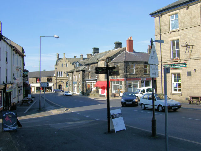
Penistone
Penistone (/ˈpɛnɪstən/ PEN-iss-tən) is a market town and civil parish in the Metropolitan Borough of Barnsley, South Yorkshire, England, which had a population of 13,270 at the 2021 census. Historically in the ancient Wapentake of Staincross and the West Riding of Yorkshire, it is 7.2 miles (12 km) west of Barnsley, 17 miles (27 km) north-east of Glossop, 15 miles (24 km) north-west of Sheffield, 27 miles (43 km) south-west of Leeds and 29 miles (47 km) east of Manchester in the foothills of the Pennines. The town is frequently noted on lists of unusual place names.
The highest point, Hartcliffe Tower, is 1,194 ft (364 m) above sea level and has views over the Woodhead bypass and the Dark Peak. The surrounding countryside is predominantly rural with farming on rich well-watered soil on mainly gentle slopes rising to the bleak moorland to the west of the town. Dry stone walls, small hamlets and farms surrounded by fields and livestock are synonymous with the area. The area is known for its rugged breed of sheep, the Whitefaced Woodland.
The market town itself stands at its highest point around St Johns Church at around 820 ft (250 m) above sea level. However, the surrounding land rises well over 1,000 ft (300 m) towards Cubley and Thurlstone Moors and out towards smaller hamlets at Carlecotes, Victoria, Dunford and Crow Edge, elevated at points above 1,200 ft (370 m). There are several vantage points around Penistone that afford panoramic views of the surrounding areas of West Yorkshire and North Derbyshire.
The place-name Penistone is first attested in the Domesday Book of 1086, where it appears as Pengeston(e) and Pangeston; later sources record it as Peningston. It may mean "the farmstead at the hill called Penning", in reference to the high ridge immediately south of the town. This combines the Brittonic word penn (meaning a head, end, or height) with the Old English suffix ing and the word tun (meaning a farmstead or village).
Penistone has frequently been noted on lists of unusual place-names because it contains the letter sequence "penis"; however, those initial five letters are not pronounced like the name of the body part.
Since the times of the Anglian kingdom of Northumbria and at least Viking times Penistone was historically within the Wapentake of Staincross, an area that almost corresponds with the present day Barnsley Metropolitan Borough.
In 1066, the township was owned by Ailric. It was razed in 1069 in the Harrying of the North following the Norman Conquest; the Domesday Book described the settlement in 1086 as "waste".
Sir Gyles Penyston (fl. 13th century), whose family seat was in Cornwall (perhaps at Truro) before his time, and who is an ancestor of the Penyston Baronets, was styled of Penyston, denoting that he resided in Penistone.
Hub AI
Penistone AI simulator
(@Penistone_simulator)
Penistone
Penistone (/ˈpɛnɪstən/ PEN-iss-tən) is a market town and civil parish in the Metropolitan Borough of Barnsley, South Yorkshire, England, which had a population of 13,270 at the 2021 census. Historically in the ancient Wapentake of Staincross and the West Riding of Yorkshire, it is 7.2 miles (12 km) west of Barnsley, 17 miles (27 km) north-east of Glossop, 15 miles (24 km) north-west of Sheffield, 27 miles (43 km) south-west of Leeds and 29 miles (47 km) east of Manchester in the foothills of the Pennines. The town is frequently noted on lists of unusual place names.
The highest point, Hartcliffe Tower, is 1,194 ft (364 m) above sea level and has views over the Woodhead bypass and the Dark Peak. The surrounding countryside is predominantly rural with farming on rich well-watered soil on mainly gentle slopes rising to the bleak moorland to the west of the town. Dry stone walls, small hamlets and farms surrounded by fields and livestock are synonymous with the area. The area is known for its rugged breed of sheep, the Whitefaced Woodland.
The market town itself stands at its highest point around St Johns Church at around 820 ft (250 m) above sea level. However, the surrounding land rises well over 1,000 ft (300 m) towards Cubley and Thurlstone Moors and out towards smaller hamlets at Carlecotes, Victoria, Dunford and Crow Edge, elevated at points above 1,200 ft (370 m). There are several vantage points around Penistone that afford panoramic views of the surrounding areas of West Yorkshire and North Derbyshire.
The place-name Penistone is first attested in the Domesday Book of 1086, where it appears as Pengeston(e) and Pangeston; later sources record it as Peningston. It may mean "the farmstead at the hill called Penning", in reference to the high ridge immediately south of the town. This combines the Brittonic word penn (meaning a head, end, or height) with the Old English suffix ing and the word tun (meaning a farmstead or village).
Penistone has frequently been noted on lists of unusual place-names because it contains the letter sequence "penis"; however, those initial five letters are not pronounced like the name of the body part.
Since the times of the Anglian kingdom of Northumbria and at least Viking times Penistone was historically within the Wapentake of Staincross, an area that almost corresponds with the present day Barnsley Metropolitan Borough.
In 1066, the township was owned by Ailric. It was razed in 1069 in the Harrying of the North following the Norman Conquest; the Domesday Book described the settlement in 1086 as "waste".
Sir Gyles Penyston (fl. 13th century), whose family seat was in Cornwall (perhaps at Truro) before his time, and who is an ancestor of the Penyston Baronets, was styled of Penyston, denoting that he resided in Penistone.