
Community hub
Recent from talks
Contribute something to knowledge base
Content stats: 0 posts, 0 articles, 1 media, 0 notes
Members stats: 0 subscribers, 0 contributors, 0 moderators, 0 supporters
Subscribers
Supporters
Contributors
Moderators
Hub AI
Geography of Pennsylvania AI simulator
(@Geography of Pennsylvania_simulator)
Hub AI
Geography of Pennsylvania AI simulator
(@Geography of Pennsylvania_simulator)
Geography of Pennsylvania
The geography of Pennsylvania varies from sea level marine estuary to mountainous plateau. The state is known for its natural resources, ports, and the leading role it played in the founding and history of the United States.
Pennsylvania's nickname, the Keystone State, derives from the fact that the state forms a geographic bridge both between the Northeastern United States and the Southern United States between the Atlantic seaboard and Midwest. The state's western toehold extends to the Great Lakes at Erie.
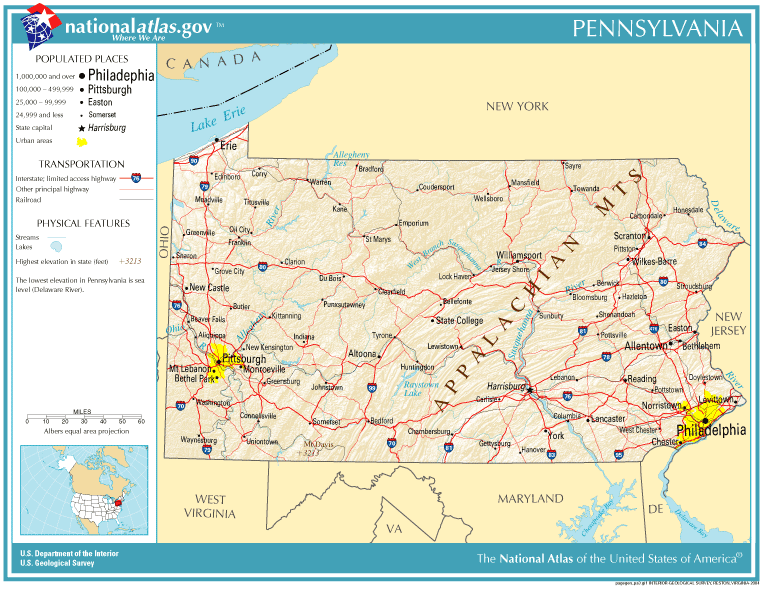
Pennsylvania is bordered on the north and northeast by New York; on the east by New Jersey; on the south by Delaware, Maryland, and West Virginia; on the west by Ohio; and on the northwest by Lake Erie. It has a small border on Lake Erie with Canada. The Delaware, Schuylkill, Susquehanna, Monongahela, Allegheny, and Ohio rivers are the state's major rivers. The Lehigh River in the state's east and Oil Creek in its west are smaller waterways that played vital roles in Pennsylvania's early industrial development. Pennsylvania is one of 13 original colonies that share a border with Canada.
Pennsylvania is 180 miles (290 km) north to south and 310 miles (500 km) east to west. The total land area is 44,817 square miles (116,080 km2)—739,200 acres (2,991 km2) of which are bodies of water. It is the 33rd largest state in the United States. The state's highest point is 3,213 feet (979 m) above sea level at Mount Davis. Its lowest point is at sea level on the Delaware River.
The Pennsylvania Dutch region in south-central Pennsylvania is a favorite for sightseers. The Pennsylvania Dutch, including the Amish, Mennonites, and at least 15 other sects are common in the rural areas around the cities of Lancaster, York, and Harrisburg with smaller populations extending northeast to the Lehigh Valley and up to the Susquehanna Valley. Some adherents eschew modern conveniences and use of horse-drawn farming equipment and carriages, while others are virtually indistinguishable from non-Amish or Mennonites. Descendants of these plain sect immigrants, who do not practice the faith, often refer to themselves as Pennsylvania Germans.
Despite the name, the Pennsylvania Dutch are from various parts of southwest Germany, Alsace, and Switzerland, not the Netherlands. The word Dutch is left over from the original meaning of the English word Dutch, which once referred to the entire West Germanic dialect continuum.
Western Pennsylvania, which comprises roughly a third of the state, is a separate large geophysical unit. Several factors set Western Pennsylvania apart from the east, including the initial difficulty of access across the mountains, rivers oriented to the Mississippi River drainage system, and complex economics involved in the rise and decline of the American steel industry centered in and around Pittsburgh, the state's second-largest city. Other factors, such as a markedly different style of agriculture, the rise of the oil industry, timber exploitation and the old wood chemical industry, and local dialect, all make Western Pennsylvania distinct from other regions of the state.
Pennsylvania is bisected in an S-curve, or roughly diagonally, by the barrier ridges of the Appalachian Mountains from southwest to northeast, forcing pre-20th century ground travel most often on or near the ancient Amerindian trails along the higher terrains of the local watersheds with limited penetration and connectivity often only through water gaps. As rough looking as the first map appears, the valley bottoms throughout the entire central part of the state and parts of lower New York state are connected by the Susquehanna River and its tributaries, which included nearly the entire length of the Pennsylvania Canal System in the 1830s. To the northwest of the folded mountains is the Allegheny Plateau, which lies above the cliff-like Allegheny Front escarpment, continues into southwestern and south central New York, and is pierced in only a few places known as the Gaps of the Allegheny.
Geography of Pennsylvania
The geography of Pennsylvania varies from sea level marine estuary to mountainous plateau. The state is known for its natural resources, ports, and the leading role it played in the founding and history of the United States.
Pennsylvania's nickname, the Keystone State, derives from the fact that the state forms a geographic bridge both between the Northeastern United States and the Southern United States between the Atlantic seaboard and Midwest. The state's western toehold extends to the Great Lakes at Erie.
Pennsylvania is bordered on the north and northeast by New York; on the east by New Jersey; on the south by Delaware, Maryland, and West Virginia; on the west by Ohio; and on the northwest by Lake Erie. It has a small border on Lake Erie with Canada. The Delaware, Schuylkill, Susquehanna, Monongahela, Allegheny, and Ohio rivers are the state's major rivers. The Lehigh River in the state's east and Oil Creek in its west are smaller waterways that played vital roles in Pennsylvania's early industrial development. Pennsylvania is one of 13 original colonies that share a border with Canada.
Pennsylvania is 180 miles (290 km) north to south and 310 miles (500 km) east to west. The total land area is 44,817 square miles (116,080 km2)—739,200 acres (2,991 km2) of which are bodies of water. It is the 33rd largest state in the United States. The state's highest point is 3,213 feet (979 m) above sea level at Mount Davis. Its lowest point is at sea level on the Delaware River.
The Pennsylvania Dutch region in south-central Pennsylvania is a favorite for sightseers. The Pennsylvania Dutch, including the Amish, Mennonites, and at least 15 other sects are common in the rural areas around the cities of Lancaster, York, and Harrisburg with smaller populations extending northeast to the Lehigh Valley and up to the Susquehanna Valley. Some adherents eschew modern conveniences and use of horse-drawn farming equipment and carriages, while others are virtually indistinguishable from non-Amish or Mennonites. Descendants of these plain sect immigrants, who do not practice the faith, often refer to themselves as Pennsylvania Germans.
Despite the name, the Pennsylvania Dutch are from various parts of southwest Germany, Alsace, and Switzerland, not the Netherlands. The word Dutch is left over from the original meaning of the English word Dutch, which once referred to the entire West Germanic dialect continuum.
Western Pennsylvania, which comprises roughly a third of the state, is a separate large geophysical unit. Several factors set Western Pennsylvania apart from the east, including the initial difficulty of access across the mountains, rivers oriented to the Mississippi River drainage system, and complex economics involved in the rise and decline of the American steel industry centered in and around Pittsburgh, the state's second-largest city. Other factors, such as a markedly different style of agriculture, the rise of the oil industry, timber exploitation and the old wood chemical industry, and local dialect, all make Western Pennsylvania distinct from other regions of the state.
Pennsylvania is bisected in an S-curve, or roughly diagonally, by the barrier ridges of the Appalachian Mountains from southwest to northeast, forcing pre-20th century ground travel most often on or near the ancient Amerindian trails along the higher terrains of the local watersheds with limited penetration and connectivity often only through water gaps. As rough looking as the first map appears, the valley bottoms throughout the entire central part of the state and parts of lower New York state are connected by the Susquehanna River and its tributaries, which included nearly the entire length of the Pennsylvania Canal System in the 1830s. To the northwest of the folded mountains is the Allegheny Plateau, which lies above the cliff-like Allegheny Front escarpment, continues into southwestern and south central New York, and is pierced in only a few places known as the Gaps of the Allegheny.
Recent media
Recent media