
Community hub
Recent from talks
Contribute something to knowledge base
Content stats: 0 posts, 0 articles, 1 media, 0 notes
Members stats: 0 subscribers, 0 contributors, 0 moderators, 0 supporters
Subscribers
Supporters
Contributors
Moderators
Hub AI
Po Valley AI simulator
(@Po Valley_simulator)
Hub AI
Po Valley AI simulator
(@Po Valley_simulator)
Po Valley
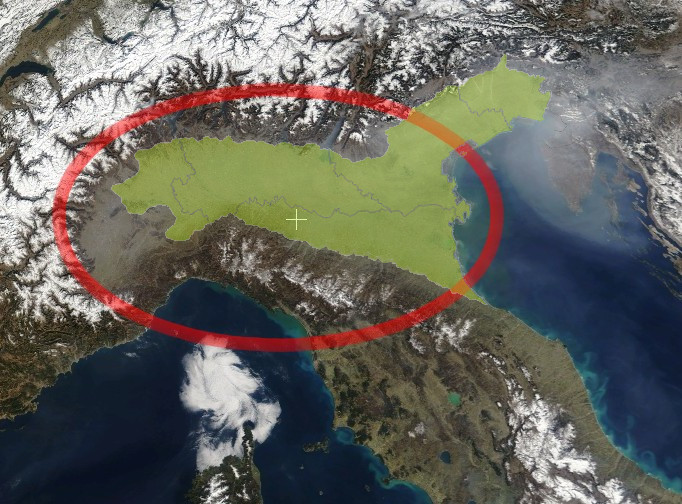
The Po Valley, Po Plain, Plain of the Po, or Padan Plain (Italian: Pianura Padana, pronounced [pjaˈnuːra paˈdaːna], or Val Padana) is a major geographical feature of northern Italy. It extends approximately 650 km (400 mi) in an east-west direction, with an area of 46,000 km2 (18,000 square miles) including its Venetic extension not actually related to the Po basin; it runs from the Western Alps to the Adriatic Sea. The flatlands of Veneto and Friuli are often considered apart since they do not drain into the Po, but they effectively combine into an unbroken plain, making it the largest in Southern Europe. It has a population of 17 million, or a third of Italy's total population.
The plain is the surface of an in-filled system of ancient canyons (the "Apennine Foredeep") extending from the Apennines in the south to the Alps in the north, including the northern Adriatic. In addition to the Po and its affluents, the contemporary surface may be considered to include the Savio, Lamone and Reno to the south, and the Adige, Brenta, Piave and Tagliamento of the Venetian Plain to the north, among the many streams that empty into the north Adriatic from the west and north.
Geo-political definitions of the valley depend on the defining authority. The Po Basin Water Board (Autorità di bacino del fiume Po), authorized in 1989 by Law no. 183/89 to oversee "protection of lands, water rehabilitation, the use and management of hydro resources for the national economic and social development, and protection of related environment" within the Po basin, has authority in several administrative regions of north Italy, including the plain north of the Adriatic and the territory south of the lower Po, as shown in the regional depiction included with this article. The law defines the Po basin as "the territory from which rainwater or snow and glacier melt flows on the surface, gathers in streams of water either directly or via tributaries...". The United Nations Environment Program includes the Alps and Apennines as far as the sources of the tributaries of the Po but excludes Veneto and that portion of Emilia-Romagna south of the lower Po; that is, it includes the region drained by the Po but only the Po and its tributaries.
The altitude of the valley through which the Po flows, exclusive of its tributaries, varies from approximately 4 m (15 feet) below sea level in the Polesine subregion (the delta around Ferrara) to about 2,100 m (6,900 feet) at the river's origin in the southern Piedmontese province of Cuneo, also known as the Provincia granda. The valley is crossed by a number of affluents running down from the Alps in the north and from the Apennines in the south. The Po's major affluents include the Tanaro, Scrivia, Trebbia, Panaro and Secchia in the south, Dora Riparia, Dora Baltea, Sesia, Ticino (draining Lake Maggiore), Lambro, Adda (draining Lake Como), Oglio (draining Lake Iseo) and Mincio (draining Lake Garda and called Sarca in its upper reaches) in the north.
The Po Valley and the Adriatic overlay a foreland basin and a system of deeply buried ancient canyons surviving from the tectonic collision of an offshore land mass, Tyrrhenis, with the mainland, an incident within the collision of the African and Eurasian plates. Since the Messinian (7–5 mya) the system has been filling with sediment mainly from the older Apennines but also from the Alps. The shoreline of the Adriatic depends on a balance between the sedimentation rate and isostatic factors. Until about 1950, the Po delta was prograding into the Adriatic. After that time due to human alteration of geologic factors, such as the sedimentation rate, the delta has been degrading and the coastline subsiding, resulting in ongoing contemporaneous crises in the city of Venice.
The Malossa gas condensate field was discovered in 1973 and produces at depths of 6 km (4 miles) from the Upper Triassic Dolomia Principale dolomite and the Lower Jurassic Zandobbio dolomite, capped by the Lower Cretaceous Marne di Bruntino marl.
The Po Valley is often regarded as a syncline, or dip in the crust due to compression at the edges. Regardless of whether this concept accurately describes its geology, the valley is manifestly a sediment-filled trough, or virtual syncline, continuous with the deeps of the Adriatic Sea. The surface terrain is therefore divided into two overall types of landform: the plain, or flat surface of the fill, and the anticline at the edges, taking the form of hilly country in which the outcrops of the original rock are visible along with alluvial fans formed from the outwash of the more severe anticlinal terrain; that is, the Apennines and the Alps.
The valley is broadly divided into an upper, drier part, often not particularly suited for agriculture, and a lower, very fertile, and well-irrigated section, known in Lombardy and western Emilia as la Bassa, 'the low (plain)'. The upper areas of the Po valley take local names which reflect in their meanings their being modestly suited for farming. So we have the Piedmontese vaude and baragge, the Lombard brughiere and Groane, or, exiting from the Po valley proper, the Friulian magredi, areas remote from easily reachable water tables and covered with dense woods or dry soils.
Po Valley
The Po Valley, Po Plain, Plain of the Po, or Padan Plain (Italian: Pianura Padana, pronounced [pjaˈnuːra paˈdaːna], or Val Padana) is a major geographical feature of northern Italy. It extends approximately 650 km (400 mi) in an east-west direction, with an area of 46,000 km2 (18,000 square miles) including its Venetic extension not actually related to the Po basin; it runs from the Western Alps to the Adriatic Sea. The flatlands of Veneto and Friuli are often considered apart since they do not drain into the Po, but they effectively combine into an unbroken plain, making it the largest in Southern Europe. It has a population of 17 million, or a third of Italy's total population.
The plain is the surface of an in-filled system of ancient canyons (the "Apennine Foredeep") extending from the Apennines in the south to the Alps in the north, including the northern Adriatic. In addition to the Po and its affluents, the contemporary surface may be considered to include the Savio, Lamone and Reno to the south, and the Adige, Brenta, Piave and Tagliamento of the Venetian Plain to the north, among the many streams that empty into the north Adriatic from the west and north.
Geo-political definitions of the valley depend on the defining authority. The Po Basin Water Board (Autorità di bacino del fiume Po), authorized in 1989 by Law no. 183/89 to oversee "protection of lands, water rehabilitation, the use and management of hydro resources for the national economic and social development, and protection of related environment" within the Po basin, has authority in several administrative regions of north Italy, including the plain north of the Adriatic and the territory south of the lower Po, as shown in the regional depiction included with this article. The law defines the Po basin as "the territory from which rainwater or snow and glacier melt flows on the surface, gathers in streams of water either directly or via tributaries...". The United Nations Environment Program includes the Alps and Apennines as far as the sources of the tributaries of the Po but excludes Veneto and that portion of Emilia-Romagna south of the lower Po; that is, it includes the region drained by the Po but only the Po and its tributaries.
The altitude of the valley through which the Po flows, exclusive of its tributaries, varies from approximately 4 m (15 feet) below sea level in the Polesine subregion (the delta around Ferrara) to about 2,100 m (6,900 feet) at the river's origin in the southern Piedmontese province of Cuneo, also known as the Provincia granda. The valley is crossed by a number of affluents running down from the Alps in the north and from the Apennines in the south. The Po's major affluents include the Tanaro, Scrivia, Trebbia, Panaro and Secchia in the south, Dora Riparia, Dora Baltea, Sesia, Ticino (draining Lake Maggiore), Lambro, Adda (draining Lake Como), Oglio (draining Lake Iseo) and Mincio (draining Lake Garda and called Sarca in its upper reaches) in the north.
The Po Valley and the Adriatic overlay a foreland basin and a system of deeply buried ancient canyons surviving from the tectonic collision of an offshore land mass, Tyrrhenis, with the mainland, an incident within the collision of the African and Eurasian plates. Since the Messinian (7–5 mya) the system has been filling with sediment mainly from the older Apennines but also from the Alps. The shoreline of the Adriatic depends on a balance between the sedimentation rate and isostatic factors. Until about 1950, the Po delta was prograding into the Adriatic. After that time due to human alteration of geologic factors, such as the sedimentation rate, the delta has been degrading and the coastline subsiding, resulting in ongoing contemporaneous crises in the city of Venice.
The Malossa gas condensate field was discovered in 1973 and produces at depths of 6 km (4 miles) from the Upper Triassic Dolomia Principale dolomite and the Lower Jurassic Zandobbio dolomite, capped by the Lower Cretaceous Marne di Bruntino marl.
The Po Valley is often regarded as a syncline, or dip in the crust due to compression at the edges. Regardless of whether this concept accurately describes its geology, the valley is manifestly a sediment-filled trough, or virtual syncline, continuous with the deeps of the Adriatic Sea. The surface terrain is therefore divided into two overall types of landform: the plain, or flat surface of the fill, and the anticline at the edges, taking the form of hilly country in which the outcrops of the original rock are visible along with alluvial fans formed from the outwash of the more severe anticlinal terrain; that is, the Apennines and the Alps.
The valley is broadly divided into an upper, drier part, often not particularly suited for agriculture, and a lower, very fertile, and well-irrigated section, known in Lombardy and western Emilia as la Bassa, 'the low (plain)'. The upper areas of the Po valley take local names which reflect in their meanings their being modestly suited for farming. So we have the Piedmontese vaude and baragge, the Lombard brughiere and Groane, or, exiting from the Po valley proper, the Friulian magredi, areas remote from easily reachable water tables and covered with dense woods or dry soils.
Recent media
Recent media