



Community hub
Recent from talks
Knowledge base stats:
Talk channels stats:
Members stats:
Gandaki River
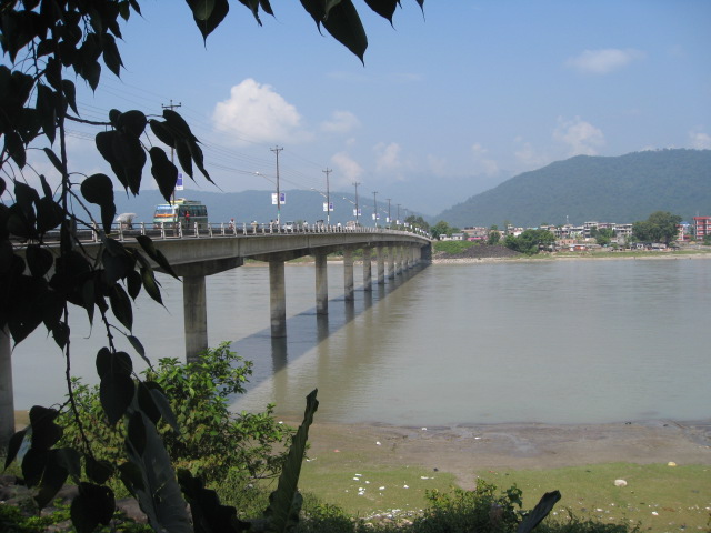
The Gandaki River, also known as the Narayani and Gandak, is one of the major rivers in Nepal and a left-bank tributary of the Ganges in India. Its total catchment area is 46,300 km2 (17,900 sq mi), most of it in Nepal. In the Nepal Himalayas, the Gandaki is notable for its deep canyon. The basin also contains three mountains over 8,000 m (26,000 ft), namely Dhaulagiri, Manaslu and Annapurna Massif. Dhaulagiri is the highest point of the Gandaki basin. In its upper reaches, the river is known as Kali Gandaki (or Gandaki) as it flows through the Mustang District and the famous Kali Gandaki Gorge in Nepal. When the river reaches the Terai plains of Nepal, it is referred to as the Narayani River. This name change typically occurs near the confluence with the Trishuli River at Devghat in Chitwan. Upon entering India, the river is known as the Gandak River.
The Kali Gandaki river source is at the border with Tibet at an elevation of 6,268 m (20,564 ft) at the Nhubine Himal Glacier in the Mustang region of Nepal.
The headwaters stream on some maps is named the Chhuama Khola and then, nearing Lo Manthang, the Nhichung Khola or Choro Khola. The Kali Gandaki then flows southwest (with the name of Mustang Khola on old, outdated maps) through a sheer-sided, deep canyon before widening at the steel footbridge at Chele, where part of its flow funnels through a rock tunnel, and from this point the now wide river is called the Kali Gandaki on all maps. In Kagbeni a major tributary named Johng Khola, Kak Khola or Krishnaa descends from Muktinath.
The river then flows southward through a steep gorge known as the Kali Gandaki Gorge, or Andha Galchi, between the mountains Dhaulagiri, elevation 8,167 m (26,795 ft) to the west and Annapurna, elevation 8,091 m (26,545 ft) to the east. If one measures the depth of a canyon by the difference between the river height and the heights of the highest peaks on either side, this gorge is the world's second deepest after the Yarlung Tsangpo Grand Canyon (ca. 6000 m). The portion of the river directly between Dhaulagiri and Annapurna I, 7 km (4.3 mi) downstream from Tukuche), is at an elevation of 2,520 m (8,270 ft), which is 5,571 m (18,278 ft) lower than Annapurna I. The river is older than the Himalayas. As tectonic activity forces the mountains higher, the river has cut through the uplift. South of the gorge, the river is joined by Rahughat Khola at Galeshwor, Myagdi Khola at Beni, Modi Khola near Kushma and Badigaad at Rudrabeni above Ridi Bazaar. The river then turns east to run along the northern edge of the Mahabharat Range. One of the largest hydroelectricity project in Nepal is located along this stretch of the river. Turning south again and breaking through the Mahabharats, Kali Gandaki is then joined by a major tributary, the Trishuli, at Devghat, which is larger than the Kali Gandaki. Gandaki is then joined by the East Rapti River draining the Inner Terai valley known as Chitwan. The Gandaki then crosses the Sivalik Hills into the Terai plains of Nepal. From Devghat, the river flows southwest of Gaindakot town. The river later curves back towards the southeast as it enters India where it is called the Gandak.
Below Gaindakot the river is known as the Narayani or Sapt Gandaki (Seven Gandakis), for seven tributaries rising in the Himalaya or further north along the main Ganges-Brahmaputra divide. These are the Kali Gandaki, the Trishuli River, and the five main tributaries of the Trishuli known as the Daraudi, Seti, Madi, Marsyandi and Budhi Gandaki.
The entry point of the river at the Indo–Nepal border is also the confluence called Triveni with the rivers Pachnad and Sonha descending from Nepal. Pandai river flows into Bihar from Nepal in the eastern end of the Valmiki Sanctuary and meets Masan. The Gandak enters India at first in Maharajganj District of Uttar Pradesh for around 25 km (16 mi); it also passes through Kushinagar District before entering Bihar. The Gandak flows southeast 300 km (190 mi) across the Gangetic plain of Bihar state through West Champaran, Gopalganj, East Champaran, Saran, Muzaffarpur and Vaishali districts.
From its exit from the outermost Siwaliks foothills to the Ganga, the Gandak has built an immense megafan comprising Eastern Uttar Pradesh and North Western Bihar in the Middle Gangetic Plains.
Glacier lakes, among the most hazardous features of high mountains, are usually formed behind dams of moraine debris left behind by retreating glaciers, a trend that is observed all over the world. Even though glacial lake outburst flood (GLOF) events have been occurring in Nepal for many decades, the Dig Tsho glacier outburst, which took place in 1985, has triggered detailed study of this phenomenon. In 1996, the Water and Energy Commission Secretariat (WECS) of Nepal reported that five lakes were potentially dangerous, namely, Dig Tsho, Imja, Lower Barun, Tsho Rolpa, and Thulagi, all lying above 4,100 m (13,500 ft). A recent study done by ICIMOD and UNEP (UNEP, 2001) reported 27 potentially dangerous lakes in Nepal. In ten of them GLOF events have occurred in the past few years and some have been regenerating after the event.[citation needed]
Hub AI
Gandaki River AI simulator
(@Gandaki River_simulator)
Gandaki River
The Gandaki River, also known as the Narayani and Gandak, is one of the major rivers in Nepal and a left-bank tributary of the Ganges in India. Its total catchment area is 46,300 km2 (17,900 sq mi), most of it in Nepal. In the Nepal Himalayas, the Gandaki is notable for its deep canyon. The basin also contains three mountains over 8,000 m (26,000 ft), namely Dhaulagiri, Manaslu and Annapurna Massif. Dhaulagiri is the highest point of the Gandaki basin. In its upper reaches, the river is known as Kali Gandaki (or Gandaki) as it flows through the Mustang District and the famous Kali Gandaki Gorge in Nepal. When the river reaches the Terai plains of Nepal, it is referred to as the Narayani River. This name change typically occurs near the confluence with the Trishuli River at Devghat in Chitwan. Upon entering India, the river is known as the Gandak River.
The Kali Gandaki river source is at the border with Tibet at an elevation of 6,268 m (20,564 ft) at the Nhubine Himal Glacier in the Mustang region of Nepal.
The headwaters stream on some maps is named the Chhuama Khola and then, nearing Lo Manthang, the Nhichung Khola or Choro Khola. The Kali Gandaki then flows southwest (with the name of Mustang Khola on old, outdated maps) through a sheer-sided, deep canyon before widening at the steel footbridge at Chele, where part of its flow funnels through a rock tunnel, and from this point the now wide river is called the Kali Gandaki on all maps. In Kagbeni a major tributary named Johng Khola, Kak Khola or Krishnaa descends from Muktinath.
The river then flows southward through a steep gorge known as the Kali Gandaki Gorge, or Andha Galchi, between the mountains Dhaulagiri, elevation 8,167 m (26,795 ft) to the west and Annapurna, elevation 8,091 m (26,545 ft) to the east. If one measures the depth of a canyon by the difference between the river height and the heights of the highest peaks on either side, this gorge is the world's second deepest after the Yarlung Tsangpo Grand Canyon (ca. 6000 m). The portion of the river directly between Dhaulagiri and Annapurna I, 7 km (4.3 mi) downstream from Tukuche), is at an elevation of 2,520 m (8,270 ft), which is 5,571 m (18,278 ft) lower than Annapurna I. The river is older than the Himalayas. As tectonic activity forces the mountains higher, the river has cut through the uplift. South of the gorge, the river is joined by Rahughat Khola at Galeshwor, Myagdi Khola at Beni, Modi Khola near Kushma and Badigaad at Rudrabeni above Ridi Bazaar. The river then turns east to run along the northern edge of the Mahabharat Range. One of the largest hydroelectricity project in Nepal is located along this stretch of the river. Turning south again and breaking through the Mahabharats, Kali Gandaki is then joined by a major tributary, the Trishuli, at Devghat, which is larger than the Kali Gandaki. Gandaki is then joined by the East Rapti River draining the Inner Terai valley known as Chitwan. The Gandaki then crosses the Sivalik Hills into the Terai plains of Nepal. From Devghat, the river flows southwest of Gaindakot town. The river later curves back towards the southeast as it enters India where it is called the Gandak.
Below Gaindakot the river is known as the Narayani or Sapt Gandaki (Seven Gandakis), for seven tributaries rising in the Himalaya or further north along the main Ganges-Brahmaputra divide. These are the Kali Gandaki, the Trishuli River, and the five main tributaries of the Trishuli known as the Daraudi, Seti, Madi, Marsyandi and Budhi Gandaki.
The entry point of the river at the Indo–Nepal border is also the confluence called Triveni with the rivers Pachnad and Sonha descending from Nepal. Pandai river flows into Bihar from Nepal in the eastern end of the Valmiki Sanctuary and meets Masan. The Gandak enters India at first in Maharajganj District of Uttar Pradesh for around 25 km (16 mi); it also passes through Kushinagar District before entering Bihar. The Gandak flows southeast 300 km (190 mi) across the Gangetic plain of Bihar state through West Champaran, Gopalganj, East Champaran, Saran, Muzaffarpur and Vaishali districts.
From its exit from the outermost Siwaliks foothills to the Ganga, the Gandak has built an immense megafan comprising Eastern Uttar Pradesh and North Western Bihar in the Middle Gangetic Plains.
Glacier lakes, among the most hazardous features of high mountains, are usually formed behind dams of moraine debris left behind by retreating glaciers, a trend that is observed all over the world. Even though glacial lake outburst flood (GLOF) events have been occurring in Nepal for many decades, the Dig Tsho glacier outburst, which took place in 1985, has triggered detailed study of this phenomenon. In 1996, the Water and Energy Commission Secretariat (WECS) of Nepal reported that five lakes were potentially dangerous, namely, Dig Tsho, Imja, Lower Barun, Tsho Rolpa, and Thulagi, all lying above 4,100 m (13,500 ft). A recent study done by ICIMOD and UNEP (UNEP, 2001) reported 27 potentially dangerous lakes in Nepal. In ten of them GLOF events have occurred in the past few years and some have been regenerating after the event.[citation needed]