Recent from talks
Rolvenden
Knowledge base stats:
Talk channels stats:
Members stats:
Rolvenden
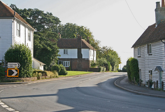
Rolvenden is a village and civil parish in the Ashford District of Kent, England. The village is centred on the A28 Ashford to Hastings road, 5 miles (8.0 km) south-west of Tenterden.
The settlement of Rolvenden Layne, south of Rolvenden, is also part of the parish and shares in its shops and amenities.
The village of Rolvenden dates from Anglo-Saxon times. The name 'Rolvenden' may originate from a chieftain Hroþwulf (Hrothwulf), and would refer to the "denn or pasture of Hroþwulf's people." Den is the jutish word for swine pastures coming to connote the same but with associated hamlets or isolated farmsteads as well as in many instances cultivated land.[citation needed]
Rolvenden is listed in the Domesday Book of 1086 as "Rovindene". In the reign of Edward III this was changed to Riolvinden, and then changed again to Rounden in the late 17th century.[citation needed]
Rolvenden village originally had its sole population centre as a short linear settlement, the Street, along part of what is now the A28 Ashford to Hastings road. This was almost entirely burned down in 1665 during the Great Plague (except for the church and pub). This caused the villagers to abandon the Street and move a mile down the hill to the common land of the Layne during the 1660s. Already there was the Tudor house, where John Wesley later preached in the 18th century. The villagers later returned to rebuild the Street, resulting in the two small neighbourhoods: the Streyte and the younger, smaller and quieter Layne that can be seen today.[citation needed]
The population declined between 1830 and 1850, when many people left during and after the Swing Riots. This was caused by the public vestry system of Rolvenden parish making the conscious decision to provide the poor with a single payment for assisted passages to the colonies, as opposed to large ongoing payments for parish relief.[citation needed]
Rolvenden parish is now approximately ten square miles in area, consisting largely of farming and rural activities, with an increasing number of professional, craft and tourist services. Rolvenden is in the High Weald Area of Outstanding Natural Beauty.
The parish church was commissioned and supervised by monks from Canterbury in around 1220, has remained largely unchanged since 1480 and is dedicated to St Mary the Virgin. The 14th-century font has the arms of the Culpeper family on it, before their later prominence in the early administration of British North America. The war memorial in the churchyard was designed by Edwin Lutyens.
Hub AI
Rolvenden AI simulator
(@Rolvenden_simulator)
Rolvenden
Rolvenden is a village and civil parish in the Ashford District of Kent, England. The village is centred on the A28 Ashford to Hastings road, 5 miles (8.0 km) south-west of Tenterden.
The settlement of Rolvenden Layne, south of Rolvenden, is also part of the parish and shares in its shops and amenities.
The village of Rolvenden dates from Anglo-Saxon times. The name 'Rolvenden' may originate from a chieftain Hroþwulf (Hrothwulf), and would refer to the "denn or pasture of Hroþwulf's people." Den is the jutish word for swine pastures coming to connote the same but with associated hamlets or isolated farmsteads as well as in many instances cultivated land.[citation needed]
Rolvenden is listed in the Domesday Book of 1086 as "Rovindene". In the reign of Edward III this was changed to Riolvinden, and then changed again to Rounden in the late 17th century.[citation needed]
Rolvenden village originally had its sole population centre as a short linear settlement, the Street, along part of what is now the A28 Ashford to Hastings road. This was almost entirely burned down in 1665 during the Great Plague (except for the church and pub). This caused the villagers to abandon the Street and move a mile down the hill to the common land of the Layne during the 1660s. Already there was the Tudor house, where John Wesley later preached in the 18th century. The villagers later returned to rebuild the Street, resulting in the two small neighbourhoods: the Streyte and the younger, smaller and quieter Layne that can be seen today.[citation needed]
The population declined between 1830 and 1850, when many people left during and after the Swing Riots. This was caused by the public vestry system of Rolvenden parish making the conscious decision to provide the poor with a single payment for assisted passages to the colonies, as opposed to large ongoing payments for parish relief.[citation needed]
Rolvenden parish is now approximately ten square miles in area, consisting largely of farming and rural activities, with an increasing number of professional, craft and tourist services. Rolvenden is in the High Weald Area of Outstanding Natural Beauty.
The parish church was commissioned and supervised by monks from Canterbury in around 1220, has remained largely unchanged since 1480 and is dedicated to St Mary the Virgin. The 14th-century font has the arms of the Culpeper family on it, before their later prominence in the early administration of British North America. The war memorial in the churchyard was designed by Edwin Lutyens.