Recent from talks
Shebaa Farms
Knowledge base stats:
Talk channels stats:
Members stats:
Shebaa Farms
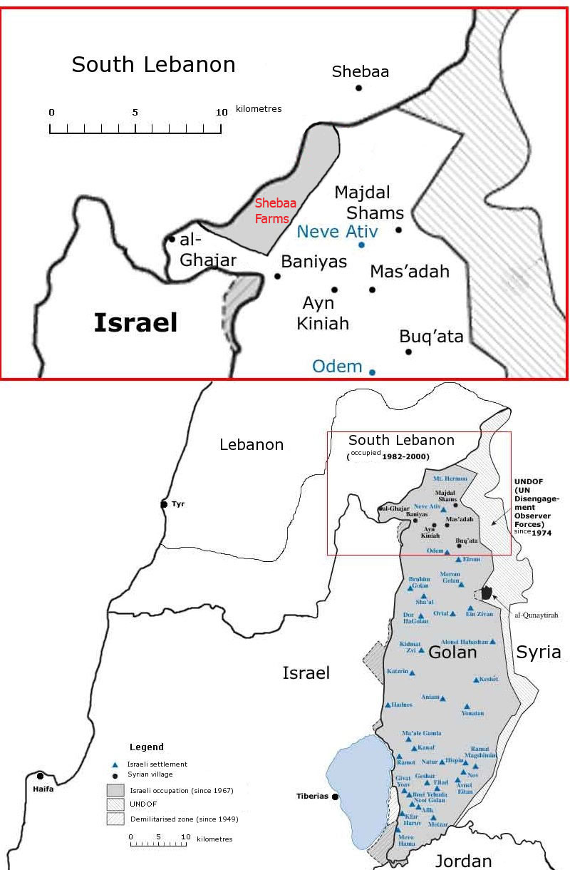
The Shebaa Farms, also spelled Sheba'a Farms (Arabic: مزارع شبعا, Mazāri' Šib‘ā; Hebrew: חוות שבעא Havot Sheba‘a), also known as Mount Dov (Hebrew: הר דב, romanized: Har Dov), is a strip of land on the Lebanese–Syrian border that is currently occupied by Israel. Lebanon claims the Shebaa Farms as its own territory, and Syria agrees with this position. Israel claims it is part of the Golan Heights, Syrian territory that it has occupied since 1967 and effectively annexed in 1981. This dispute plays a significant role in contemporary Israel–Lebanon relations.
The territory is named for the farms within it which were historically tended by the inhabitants of the Lebanese town of Shebaa. It is about 11 kilometres (7 mi) long and 2.5 kilometres (2 mi) wide. The French Mandate for Syria and the Lebanon administration did not demarcate the border between Lebanon and Syria, nor was this done later by Lebanese and Syrian governments. Documents from the 1920s and 1930s indicate that inhabitants paid taxes to the Lebanese government. From the early 1950s to Israel's occupation of the Golan Heights in the Six-Day War, Syria was the de facto ruling power. In 1978 Israel invaded and occupied Southern Lebanon. In 1981, the Golan Heights, including the Shebaa Farms, were annexed by Israel, a move not recognized by the international community. Israel considers it part of the Golan Heights and continues to hold it, along with the Golan, under military occupation.
The territory has been a flashpoint for violence since Israel withdrew from Lebanon in May 2000. Hezbollah claimed that the withdrawal was not complete because Shebaa was on Lebanese – not Syrian – territory. Following the Israeli withdrawal, the UN certified the completion of Israel's pullout. Later the United Nations Secretary General issued a statement proposing the area for the operations of the United Nations Interim Force in Lebanon; in the statement the controversy was described, with 81 different maps being studied; the UN concluded that there is no evidence of the abandoned farmlands being Lebanese, but proposed to maintain the existing boundaries of the United Nations Disengagement Observer Force in Syria (which had included the Shebaa Farms since 1967) "without prejudice" to any future agreement between Syria and Lebanon.
Low-level conflict continued in the area from 2000 to 2006 and in early 2015. In August 2008, the president of Lebanon, Michel Suleiman, stated: "The countdown for liberating the rest of our lands has begun. And today I confirm the [use] of all available and legitimate means to achieve this goal".
Shebaa Farms is an area about 9 km (5.6 mi) long, and 2.5 km (1.6 mi) wide; about 22 km2 (8.5 sq mi); 5,400 acres). The area contains 14 farms. Shebaa Farms is located about 3 to 12 km (1.9 to 7.5 mi) southwest of the Lebanese village of Shebaa, and about 5 to 7 km (3.1 to 4.3 mi) northwest of the Druze village of Majdal Shams. Shebaa Farms is on the southeastern side of a long, broad ridge descending to the southwest from Mount Hermon. The northwestern edge of the area corresponds to the international Lebanese–Syrian border recognized by the United Nations along that ridge.[citation needed] The southeastern edge follows Wadi al-Asal (Nahal Si'on), a 16 km long wadi that flows into Israel, draining a portion of the relatively precipitation-rich Hermon ridge in the northern Golan Heights. These "edges" are connected by the Shebaa Farms area's northeastern limit 2.5 km east of IDF military camp at Har Dov as defined by a 2007 UN report.[failed verification]
The same report defines the southwestern limit as a line roughly following the foot of the ridge and starting at just over a kilometer northwest of Banias, then running northwest to the international Lebanese–Syrian border's sharp turning point 3.4 km east of Ghajar and 1.0 km "south of the (Lebanese) village of El Majidiye." This southwestern limit of Shebaa Farms comes within about 1 km of the 1949 Armistice Line, international border between Israel and Syria. The only overland route between Lebanon and Syria south of the Mount Hermon ridge used to run between these two lines. The small farms in this area have not been used since the Six-Day War. The area includes heights overlooking parts of southern Lebanon and Israel to the west. Elevations range from about 250 to about 1,500 m (825–4,940 ft).
Lebanese press and officials often refer to the northern, higher part of the Shebaa Farms, just southeast of the Lebanese village of Kafr Shuba, as the Kafr Shuba Hills.[citation needed] The wide mountainous ridge in that part is called Jabel Rus (the mountain of the heads) in Arabic.
Israel refers to this northern, higher part as Har Dov (Mount Dov) after Dov Rodberg, an IDF officer killed there in 1970.
Hub AI
Shebaa Farms AI simulator
(@Shebaa Farms_simulator)
Shebaa Farms
The Shebaa Farms, also spelled Sheba'a Farms (Arabic: مزارع شبعا, Mazāri' Šib‘ā; Hebrew: חוות שבעא Havot Sheba‘a), also known as Mount Dov (Hebrew: הר דב, romanized: Har Dov), is a strip of land on the Lebanese–Syrian border that is currently occupied by Israel. Lebanon claims the Shebaa Farms as its own territory, and Syria agrees with this position. Israel claims it is part of the Golan Heights, Syrian territory that it has occupied since 1967 and effectively annexed in 1981. This dispute plays a significant role in contemporary Israel–Lebanon relations.
The territory is named for the farms within it which were historically tended by the inhabitants of the Lebanese town of Shebaa. It is about 11 kilometres (7 mi) long and 2.5 kilometres (2 mi) wide. The French Mandate for Syria and the Lebanon administration did not demarcate the border between Lebanon and Syria, nor was this done later by Lebanese and Syrian governments. Documents from the 1920s and 1930s indicate that inhabitants paid taxes to the Lebanese government. From the early 1950s to Israel's occupation of the Golan Heights in the Six-Day War, Syria was the de facto ruling power. In 1978 Israel invaded and occupied Southern Lebanon. In 1981, the Golan Heights, including the Shebaa Farms, were annexed by Israel, a move not recognized by the international community. Israel considers it part of the Golan Heights and continues to hold it, along with the Golan, under military occupation.
The territory has been a flashpoint for violence since Israel withdrew from Lebanon in May 2000. Hezbollah claimed that the withdrawal was not complete because Shebaa was on Lebanese – not Syrian – territory. Following the Israeli withdrawal, the UN certified the completion of Israel's pullout. Later the United Nations Secretary General issued a statement proposing the area for the operations of the United Nations Interim Force in Lebanon; in the statement the controversy was described, with 81 different maps being studied; the UN concluded that there is no evidence of the abandoned farmlands being Lebanese, but proposed to maintain the existing boundaries of the United Nations Disengagement Observer Force in Syria (which had included the Shebaa Farms since 1967) "without prejudice" to any future agreement between Syria and Lebanon.
Low-level conflict continued in the area from 2000 to 2006 and in early 2015. In August 2008, the president of Lebanon, Michel Suleiman, stated: "The countdown for liberating the rest of our lands has begun. And today I confirm the [use] of all available and legitimate means to achieve this goal".
Shebaa Farms is an area about 9 km (5.6 mi) long, and 2.5 km (1.6 mi) wide; about 22 km2 (8.5 sq mi); 5,400 acres). The area contains 14 farms. Shebaa Farms is located about 3 to 12 km (1.9 to 7.5 mi) southwest of the Lebanese village of Shebaa, and about 5 to 7 km (3.1 to 4.3 mi) northwest of the Druze village of Majdal Shams. Shebaa Farms is on the southeastern side of a long, broad ridge descending to the southwest from Mount Hermon. The northwestern edge of the area corresponds to the international Lebanese–Syrian border recognized by the United Nations along that ridge.[citation needed] The southeastern edge follows Wadi al-Asal (Nahal Si'on), a 16 km long wadi that flows into Israel, draining a portion of the relatively precipitation-rich Hermon ridge in the northern Golan Heights. These "edges" are connected by the Shebaa Farms area's northeastern limit 2.5 km east of IDF military camp at Har Dov as defined by a 2007 UN report.[failed verification]
The same report defines the southwestern limit as a line roughly following the foot of the ridge and starting at just over a kilometer northwest of Banias, then running northwest to the international Lebanese–Syrian border's sharp turning point 3.4 km east of Ghajar and 1.0 km "south of the (Lebanese) village of El Majidiye." This southwestern limit of Shebaa Farms comes within about 1 km of the 1949 Armistice Line, international border between Israel and Syria. The only overland route between Lebanon and Syria south of the Mount Hermon ridge used to run between these two lines. The small farms in this area have not been used since the Six-Day War. The area includes heights overlooking parts of southern Lebanon and Israel to the west. Elevations range from about 250 to about 1,500 m (825–4,940 ft).
Lebanese press and officials often refer to the northern, higher part of the Shebaa Farms, just southeast of the Lebanese village of Kafr Shuba, as the Kafr Shuba Hills.[citation needed] The wide mountainous ridge in that part is called Jabel Rus (the mountain of the heads) in Arabic.
Israel refers to this northern, higher part as Har Dov (Mount Dov) after Dov Rodberg, an IDF officer killed there in 1970.
Recent media