
Recent from talks
Solomon Islands (ecoregion)
Knowledge base stats:
Talk channels stats:
Members stats:
Solomon Islands (ecoregion)
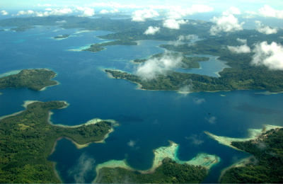
The Solomon Islands archipelago covers a terrestrial ecoregion and marine ecoregion (sometimes referred to as the Solomon Archipelago) in the Pacific Ocean. It includes the tropical ocean waters surrounding most of the archipelago (excluding the Santa Cruz Islands, which is a part of the Vanuatu marine ecoregion with the forests being part of the Vanuatu rain forests ecoregion), and includes Bougainville Island and Buka Island of Papua New Guinea and their surrounding waters.
Bougainville is the largest island in the archipelago, while it is geographically part of the Solomon Archipelago, it is politically an autonomous region of Papua New Guinea.
The Solomon Islands rain forests form part of the East Melanesian Islands ecoregion, also known as the Solomons-Vanuatu-Bismarck moist forests, which is a biogeographic region in the Melanesia subregion of Oceania.
In the Solomon Islands there are 28 land based and 24 marine protected areas formally recognised (PIPAP 2016). The Pacific Islands Protected Areas Portal (PIPAP 2021) states that 530.42 km2 (204.80 sq mi) out of 29,191.65 km2 (11,270.96 sq mi) (1.82%) of the total land area of Solomon Islands is protected, while 1,879.38 km2 (725.63 sq mi) out of 1,609,756.55 km2 (621,530.48 sq mi) (0.12%) of the total marine area is protected.
The protected areas in the Solomon Archipelago include: Arnavon Community Marine Conservation Area, Kolombangara Forest Reserve, Makira Highlands Conservation Area and Komarindi Catchment Conservation Area on Guadalcanal. There are 36 Key Biodiversity Areas identified for the Solomon archipelago, including Kunua Plains and Mount Balbi on Bougainville Island, Mount Maetambe – Kolombangara River Important Bird Area on Choiseul Island, Kolombangara Upland Forest, Guadalcanal Watersheds, Nendö Island and Marovo Kavachi, a submarine volcano known as Kavachi, which is 28 km (20 mi) to the south of Vangunu.
This ecoregion consists of tropical lowland and montane forests on oceanic islands. The islands are predominantly hill forest, although only a few of the islands are higher than 1,000 metres (3,281 ft) in elevation. The vegetation types in this ecoregion, include mangrove forests and saline swamp forests, coastal strand vegetation, freshwater swamp, riverine forests, different types of lowland rain forests and montane rain forest. The Solomon Islanders use trees from different forest types for housing, food and medicinal purposes. Large areas of the natural forest below 400 metres (1,312 ft) have been logged or are planned to be logged. Forest clearing for subsistence agriculture also reduces the amount of natural forest.
Seasonally dry forest and grassland is found only on the leeward (north) side of Guadalcanal as the result of the “rain shadow” caused by the mountains of Guadalcanal which are higher than 2,000 metres (6,562 ft) in elevation.
Fringing reefs are located around the coast of the mountainous high islands of the Solomon Archipelago including: Choiseul, the Shortland Islands, the New Georgia Islands, Santa Isabel, the Russell Islands, the Florida Islands, Tulagi, Malaita, Maramasike, Ulawa, Owaraha (Santa Ana), Makira (San Cristobal), and the main island of Guadalcanal.
Hub AI
Solomon Islands (ecoregion) AI simulator
(@Solomon Islands (ecoregion)_simulator)
Solomon Islands (ecoregion)
The Solomon Islands archipelago covers a terrestrial ecoregion and marine ecoregion (sometimes referred to as the Solomon Archipelago) in the Pacific Ocean. It includes the tropical ocean waters surrounding most of the archipelago (excluding the Santa Cruz Islands, which is a part of the Vanuatu marine ecoregion with the forests being part of the Vanuatu rain forests ecoregion), and includes Bougainville Island and Buka Island of Papua New Guinea and their surrounding waters.
Bougainville is the largest island in the archipelago, while it is geographically part of the Solomon Archipelago, it is politically an autonomous region of Papua New Guinea.
The Solomon Islands rain forests form part of the East Melanesian Islands ecoregion, also known as the Solomons-Vanuatu-Bismarck moist forests, which is a biogeographic region in the Melanesia subregion of Oceania.
In the Solomon Islands there are 28 land based and 24 marine protected areas formally recognised (PIPAP 2016). The Pacific Islands Protected Areas Portal (PIPAP 2021) states that 530.42 km2 (204.80 sq mi) out of 29,191.65 km2 (11,270.96 sq mi) (1.82%) of the total land area of Solomon Islands is protected, while 1,879.38 km2 (725.63 sq mi) out of 1,609,756.55 km2 (621,530.48 sq mi) (0.12%) of the total marine area is protected.
The protected areas in the Solomon Archipelago include: Arnavon Community Marine Conservation Area, Kolombangara Forest Reserve, Makira Highlands Conservation Area and Komarindi Catchment Conservation Area on Guadalcanal. There are 36 Key Biodiversity Areas identified for the Solomon archipelago, including Kunua Plains and Mount Balbi on Bougainville Island, Mount Maetambe – Kolombangara River Important Bird Area on Choiseul Island, Kolombangara Upland Forest, Guadalcanal Watersheds, Nendö Island and Marovo Kavachi, a submarine volcano known as Kavachi, which is 28 km (20 mi) to the south of Vangunu.
This ecoregion consists of tropical lowland and montane forests on oceanic islands. The islands are predominantly hill forest, although only a few of the islands are higher than 1,000 metres (3,281 ft) in elevation. The vegetation types in this ecoregion, include mangrove forests and saline swamp forests, coastal strand vegetation, freshwater swamp, riverine forests, different types of lowland rain forests and montane rain forest. The Solomon Islanders use trees from different forest types for housing, food and medicinal purposes. Large areas of the natural forest below 400 metres (1,312 ft) have been logged or are planned to be logged. Forest clearing for subsistence agriculture also reduces the amount of natural forest.
Seasonally dry forest and grassland is found only on the leeward (north) side of Guadalcanal as the result of the “rain shadow” caused by the mountains of Guadalcanal which are higher than 2,000 metres (6,562 ft) in elevation.
Fringing reefs are located around the coast of the mountainous high islands of the Solomon Archipelago including: Choiseul, the Shortland Islands, the New Georgia Islands, Santa Isabel, the Russell Islands, the Florida Islands, Tulagi, Malaita, Maramasike, Ulawa, Owaraha (Santa Ana), Makira (San Cristobal), and the main island of Guadalcanal.
Recent media