Recent from talks
Nothing was collected or created yet.
Southern Limestone Alps
View on Wikipedia
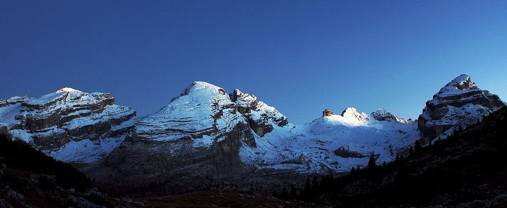
The Southern Limestone Alps (Italian: Alpi Sud-orientali, German: Südliche Kalkalpen), also called the Southern Calcareous Alps, are the ranges of the Eastern Alps south of the Central Eastern Alps mainly located in northern Italy and the adjacent lands of Austria and Slovenia. The distinction from the Central Alps, where the higher peaks are located, is based on differences in geological composition. The Southern Limestone Alps extend from the Sobretta-Gavia range in Lombardy in the west to the Pohorje in Slovenia in the east.
Key Information
Alpine Club classification
[edit]
(purple lines showing international borders and the borders of Austrian states)
Ranges of the Southern Limestone Alps according to the Alpine Club classification (from east to west):
- Pohorje (1)
- Kamnik–Savinja Alps (2)
- Karawanks (3)
- Julian Alps (4)
- Gailtal Alps (5)
- Carnic Alps (6)
- Southern Carnic Alps (7)
- Dolomites (8)
- Fiemme Mountains (9)
- Vicentine Alps (10)
- Nonsberg Group (11)
- Brenta Group (12)
- Garda Mountains (13)
- Ortler Alps (14)
- Adamello-Presanella Alps (15)
- Sobretta-Gavia Group (16)
Physiography
[edit]The Southern Alps are a distinct physiographic section of the larger Alps province, which in turn is part of the larger Alpine System physiographic division.
See also
[edit]
References
[edit]- Franz Graßler (1984), DAV; OeAV; AVS (eds.), "Alpenvereinseinteilung der Ostalpen (AVE): Alpenvereins-Jahrbuch", Berg '84 (in German), vol. 108, pp. 215–224
- Dr. Josef Moriggl (1928), Hauptausschuß des D. u. Ö. Alpenvereins (ed.), Ratgeber für Alpenwanderer in den Ostalpen: Mit Schutzhüttenverzeichnis (in German) (2 ed.), Munich
{{citation}}: CS1 maint: location missing publisher (link)
External links
[edit]
Media related to Southern Limestone Alps at Wikimedia Commons
Southern Limestone Alps
View on GrokipediaGeography
Location and Boundaries
The Southern Limestone Alps form a prominent southern branch of the Eastern Alps, extending approximately 400 km eastward from the Sobretta-Gavia range in Lombardy, Italy, to the Pohorje Mountains in northern Slovenia. This range spans roughly 20,000 km², characterized by its calcareous formations and positioned between latitudes 45.5° to 46.5° N and longitudes approximately 10° to 15.5° E.[2][3] The region primarily occupies northern Italy, encompassing the administrative regions of Lombardy, Trentino-Alto Adige, Veneto, and Friuli-Venezia Giulia, while extending into Slovenia and with minor overlaps into eastern Austria and a small portion of Switzerland. These territories reflect a transboundary alpine landscape shaped by historical geological and cultural interconnections across the Italian-Slovenian border.[2][4] The northern boundary is defined by the Periadriatic Seam, a major tectonic fault that separates the Southern Limestone Alps from the Central Eastern Alps to the north. To the south, it transitions into the Venetian Prealps and the Po Plain, marking a shift from alpine highlands to lowland plains. The western limit lies near the Lake Garda area, while the eastern extent incorporates portions of the Carnic and Julian Alps, blending into Slovenian highlands.[5][3]Extent and Subdivisions
The Southern Limestone Alps constitute a major physiographic unit within the Eastern Alps, spanning an approximate area of 20,000 km² with elevations ranging from about 200 m in the surrounding foothills to over 3,300 m at higher summits. The range forms a predominantly continuous east-west trending chain, interrupted by significant transverse valleys such as Val Camonica in the west and the Piave River valley in the central sector, which facilitate connectivity between the northern and southern flanks of the Alps. This structure aligns variably with political boundaries, notably encompassing the autonomous province of South Tyrol in Italy, where several subgroups straddle the Italian-Austrian border before extending into Slovenia eastward. The primary subdivisions of the Southern Limestone Alps follow the Alpine Club classification (Alpenvereinseinteilung der Ostalpen, AVE), which partitions the range into 15 major groups for navigational and orographic clarity. In the western sector, these include the Bergamo Alps, Adamello Group, and Brenta Group, encompassing areas like the Ortles-Cevedale subgroup. Centrally, the Dolomites dominate, incorporating the Fassa and Fiemme Dolomites along with subgroups such as the Marmarole. To the east, the Carnic Alps and Julian Alps form the concluding segments, with additional groupings like the Gailtaler Alps and Karawanks. These subdivisions reflect a progression from more isolated western massifs to interconnected eastern extensions, aiding in regional mapping and exploration.[6]Geology
Tectonic Formation
The Southern Limestone Alps, as the southern sector of the Eastern Alps, originated during the Cenozoic era through the collision of the African and Eurasian tectonic plates, which formed part of the broader Alpide orogenic belt spanning Eurasia. This convergence, beginning in the Late Cretaceous but intensifying from the Eocene to the Miocene (approximately 50 to 10 million years ago), resulted in the subduction and closure of the ancient Tethys Ocean, driving the uplift and deformation of the Alpine chain. The Adriatic microplate, a promontory of the African plate, played a central role by indenting northward into the Eurasian margin, leading to the development of the Southern Limestone Alps as an external retrowedge with predominantly south-vergent thrusting.[7] In the Alpine structure, the Southern Limestone Alps exhibit thrusting over the Adriatic plate, distinguishing them from the more complex northern nappe stacks. Key tectonic events include Oligocene nappe folding, which involved backfolding of the Adriatic margin and formation of structures like the Vanzone back-fold around 23 million years ago, followed by Miocene uplift driven by crustal wedging and exhumation rates of up to 0.65 km per million years in areas like the Adamello massif. These processes compressed and metamorphosed earlier sedimentary sequences, with total shortening estimated at about 21 km in the western Southern Alps since the Oligocene. The dominant limestone composition derives from ancient Mesozoic seabeds of the Tethys Sea.[7][8] Geological evidence supporting this formation includes abundant fossil records preserved in Tethys Sea sediments, such as marine invertebrates and foraminifera from Jurassic to Eocene carbonates, indicating initial passive margin deposition before compression. Remnants of seismic activity persist along major fault lines, notably the Insubric (Periadriatic) Line, which bounds the Southern Limestone Alps to the north and marks a dextral shear zone active from the Oligocene onward, with ongoing Quaternary deformation evidenced by earthquake foci at depths up to 20 km. The timeline begins with Mesozoic marine deposition on the Adriatic passive margin during Triassic-Jurassic rifting, transitioning to Cenozoic compression, metamorphism, and thrusting, culminating in Quaternary post-glacial isostatic rebound that has contributed to further elevation of up to 2-3 km in the massifs.[7][8]Rock Composition and Karst Features
The Southern Limestone Alps are predominantly composed of Mesozoic carbonate rocks, with limestones and dolomites forming the primary lithology. These include Upper Triassic formations such as the Dachstein Limestone, characterized by peritidal cyclic successions, and the Dolomia Principale, a thick sequence of reef-related dolomites from the late Carnian to Norian stages. Jurassic limestones, like the Calcari Grigi and Marmolada Limestone, further contribute to the massive, bedded structures typical of the range, developed in ancient shallow marine and lagoonal environments.[9] Subordinate rock types include Permian to Triassic terrigenous sediments, such as the Gardena Sandstone, and evaporites from the Bellerophon Formation, alongside minor Ladinian volcanics like pillow lavas and hyaloclastites. In the western subgroups, the Adamello Massif stands out with its Tertiary granitoid intrusions, primarily tonalite, granodiorite, and quartz diorite, representing calc-alkaline magmatism that intrudes the surrounding carbonates.[9][10] The solubility of these carbonate rocks has sculpted extensive karst landscapes through dissolution by groundwater, producing a variety of surface and subsurface features. The Kras Plateau (Carso) in the southeastern extent exemplifies this, with thousands of dolines (sinkholes), uvalas (merged sinkholes), and poljes (large, flat-floored depressions) formed by the coalescence of collapsed cavities. Over 3,490 caves are documented in the Kras alone, including the UNESCO-listed Škocjanske jama system (5.8 km long) and Kačna jama (15.18 km), where underground rivers like the Reka vanish into ponors.[11] In the Italian sector near Trieste, the Grotta Gigante represents a monumental karst chamber within Eocene to Miocene limestones, measuring 130 m long, 65 m wide, and 107 m high, highlighting the scale of dissolution processes.[11] Geological hazards in the range arise from the steep karst cliffs and jointed carbonate bedrock, prone to rockfalls and landslides triggered by weathering, heavy rainfall, or seismic activity along fault zones. For instance, large-scale rockslides in the central-eastern Southern Alps, such as those in the Giudicarie and Schio-Vicenza valleys, involve deep-seated failures in limestone slopes, posing risks to valleys and infrastructure. These events are amplified by the brittle nature of the rocks and ongoing tectonic stresses from Alpine uplift.[12] Unique paleokarst features, developed prior to major uplift, are preserved in relict surfaces and cavities across the range. In the Venetian Prealps' Lessini Mountains, late Paleogene paleokarst caves in neritic limestones exhibit phreatic dissolution morphologies filled with iron-rich paleosols, reflecting ancient coastal freshwater drainage systems during Oligocene-Miocene regressions. These contrast sharply with the crystalline schists and gneisses dominating the northern Central Alps, underscoring the Southern Limestone Alps' distinct passive-margin heritage.[13]Physiography
Major Peaks and Ranges
The Southern Limestone Alps encompass several key subranges defined within the broader Alpine subdivisions, featuring dramatic limestone and dolomitic formations that rise to significant elevations. These subranges include the iconic Dolomites, the transitional Ortles-Cevedale group, and the rugged Carnic Alps, each contributing to the region's varied topography of sharp ridges and towering summits. The Dolomites, a UNESCO World Heritage site recognized for their exceptional geological and aesthetic value, form one of the most prominent subranges with jagged towers like the Tre Cime di Lavaredo exemplifying their distinctive pinnacles. The highest peak in this subrange is Marmolada, reaching 3,343 m, while other notable summits include Antelao at 3,264 m and Cima Tofana di Rozes at 3,225 m.[14][15][16] Further east, the Carnic Alps along the Austria-Italy border feature steep faces suited to via ferratas and culminate at Monte Coglians, the subrange's highest point at 2,780 m.[17] In the western sector, the Ortles-Cevedale group marks a transitional zone with the Central Alps and hosts the overall highest summit of the Southern Limestone Alps, Ortler at 3,905 m.[18] Additional prominent peaks in the region include Mangart at 2,679 m in the Julian Alps extension.[19] The area's relief is accentuated by over a dozen ultra-prominent peaks exhibiting more than 1,500 m of prominence, such as Marmolada with 2,131 m of prominence, underscoring the independent massifs formed by erosional processes.[14] Accessibility to these highs is facilitated by historic passes like the Stelvio Pass, which crests at 2,757 m and has long served as a vital route through the terrain. Compared to the Northern Limestone Alps, the Southern ranges display steeper profiles and more dramatic forms owing to differential erosion, where resistant dolomitic layers cap softer sediments to create sheer cliffs and spires.[20]| Peak | Elevation (m) | Subrange | Prominence (m) | Source |
|---|---|---|---|---|
| Ortler | 3,905 | Ortles-Cevedale | 1,952 | Peakvisor |
| Marmolada | 3,343 | Dolomites | 2,131 | Peakbagger |
| Antelao | 3,264 | Dolomites | 1,735 | Peakbagger |
| Cima Tofana di Rozes | 3,225 | Dolomites | 664 | Peakbagger |
| Monte Coglians | 2,780 | Carnic Alps | 1,144 | Peakbagger |
| Mangart | 2,679 | Julian Alps (extension) | 1,066 | Peakbagger |

