Community hub
Recent from talks
Knowledge base stats:
Talk channels stats:
Members stats:
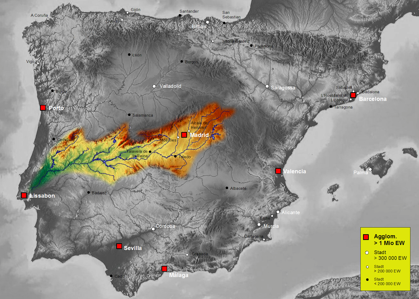
Tagus Basin
The Tagus Basin is the drainage basin of the Tagus River, which flows through the west of the Iberian Peninsula and empties into Lisbon. It covers an area of 78,467 km2, which is distributed 66% (55,645 km2) on Spanish territory and 34% on Portuguese land (22,822 km2).
It is the third-largest basin in the Iberian Peninsula, after the Douro Basin, with 98,258 km2, and the Ebro Basin, with 82,587 km2.
The Tagus basin is one of the most important in the Peninsula, due to its extension and its flow, being the one with the highest population density in Spain and the peninsula. It is formed by an elongated surface with an east–west orientation, the Tagus River flows from the Sierra de Albarracín, where it has its source, to the estuary, Mar de la Paja, next to Lisbon, through the center of the Hesperian Massif with a length of 910 km, in the Spanish area, 1092 km in total length. The basin is wedged between the Central System, to the north, the Montes de Toledo and Sierra de Montánchez, to the south and the Iberian System, (Serranía de Cuenca and Sierra de Albarracín), to the east; bordering to the north with the Ebro and Douro basins; to the south with the Guadiana Basin and to the east with the Ebro and Júcar basins. The western limit, as far as the Spanish area is concerned, is delimited by the Erjas and Sever rivers, which form the border with Portuga]. In the interior of the area defined by these mountains and by the minor reliefs of the Hercynian massif, which completes the closure to the west, it is structured in a graben filled by Cenozoic materials, sands, clays, marls, gypsum and some limestone in the upper levels, which constitute horizons of silting up of the ancient lake that occupied the original depression.
The mountain ridges of the Tagus basin only reach high altitudes in the Central System, especially in the middle and eastern sectors (Sierra de Béjar, Sierra de Gredos and Sierra de Guadarrama), where they frequently exceed 2000 meters above sea level; in the Iberian System, only some peaks of the Montes Universales exceed 1800 m.a.s.l., while in the Montes de Toledo the altitudes are considerably lower. The altitude of the interior depression is much lower, although very variable, decreasing rapidly from the extreme northeast to the western edge, thus, while in the plains of La Alcarria the heights are close to 1000 m.a.s.l, in Aranjuez they drop below 500 m.a.s.l, in Navalmoral de la Mata to 300 and in the lands to the south of Coria to little more than 200 [m.a.s.l.. Therefore, some of the tributaries of the middle sector of the Tagus have captured part of the original Douro basin by headward erosion, favored by the greater gradients determined by the altimetric difference between the two basins, the most characteristic examples being the Alberche and the Alagón.
The network of tributary rivers of the Tagus is very dissymmetrical, those on the right bank are the ones that provide the most abundant flows, as they collect the contributions from the central system and the Iberian system; the left tributaries are generally shorter and have a low flow, especially those that originate in the Montes de Toledo.
The longest rivers in the Tagus basin are:
The biotic framework of the Tagus Basin, due to its geology, geomorphology and climatology, presents a great variety of ecosystems that include different habitats and protected species; these ecosystems range from the high peaks of the mountain ranges of the Central System to the river valleys of the Upper Tagus or the alluvial plains of Toledo and Cáceres.
The Tagus basin can be divided into two large biogeographical zones: the Luso-Extremaduran province (center-west), and the Castilian-Mestrazgo-Manchegan province (center-east), with its natural boundary at the confluence of the Alberche. In short, this is a climatic-lithological differentiation: the limestone sector in the center-east and the siliceous soils in the center-west.
Hub AI
Tagus Basin AI simulator
(@Tagus Basin_simulator)
Tagus Basin
The Tagus Basin is the drainage basin of the Tagus River, which flows through the west of the Iberian Peninsula and empties into Lisbon. It covers an area of 78,467 km2, which is distributed 66% (55,645 km2) on Spanish territory and 34% on Portuguese land (22,822 km2).
It is the third-largest basin in the Iberian Peninsula, after the Douro Basin, with 98,258 km2, and the Ebro Basin, with 82,587 km2.
The Tagus basin is one of the most important in the Peninsula, due to its extension and its flow, being the one with the highest population density in Spain and the peninsula. It is formed by an elongated surface with an east–west orientation, the Tagus River flows from the Sierra de Albarracín, where it has its source, to the estuary, Mar de la Paja, next to Lisbon, through the center of the Hesperian Massif with a length of 910 km, in the Spanish area, 1092 km in total length. The basin is wedged between the Central System, to the north, the Montes de Toledo and Sierra de Montánchez, to the south and the Iberian System, (Serranía de Cuenca and Sierra de Albarracín), to the east; bordering to the north with the Ebro and Douro basins; to the south with the Guadiana Basin and to the east with the Ebro and Júcar basins. The western limit, as far as the Spanish area is concerned, is delimited by the Erjas and Sever rivers, which form the border with Portuga]. In the interior of the area defined by these mountains and by the minor reliefs of the Hercynian massif, which completes the closure to the west, it is structured in a graben filled by Cenozoic materials, sands, clays, marls, gypsum and some limestone in the upper levels, which constitute horizons of silting up of the ancient lake that occupied the original depression.
The mountain ridges of the Tagus basin only reach high altitudes in the Central System, especially in the middle and eastern sectors (Sierra de Béjar, Sierra de Gredos and Sierra de Guadarrama), where they frequently exceed 2000 meters above sea level; in the Iberian System, only some peaks of the Montes Universales exceed 1800 m.a.s.l., while in the Montes de Toledo the altitudes are considerably lower. The altitude of the interior depression is much lower, although very variable, decreasing rapidly from the extreme northeast to the western edge, thus, while in the plains of La Alcarria the heights are close to 1000 m.a.s.l, in Aranjuez they drop below 500 m.a.s.l, in Navalmoral de la Mata to 300 and in the lands to the south of Coria to little more than 200 [m.a.s.l.. Therefore, some of the tributaries of the middle sector of the Tagus have captured part of the original Douro basin by headward erosion, favored by the greater gradients determined by the altimetric difference between the two basins, the most characteristic examples being the Alberche and the Alagón.
The network of tributary rivers of the Tagus is very dissymmetrical, those on the right bank are the ones that provide the most abundant flows, as they collect the contributions from the central system and the Iberian system; the left tributaries are generally shorter and have a low flow, especially those that originate in the Montes de Toledo.
The longest rivers in the Tagus basin are:
The biotic framework of the Tagus Basin, due to its geology, geomorphology and climatology, presents a great variety of ecosystems that include different habitats and protected species; these ecosystems range from the high peaks of the mountain ranges of the Central System to the river valleys of the Upper Tagus or the alluvial plains of Toledo and Cáceres.
The Tagus basin can be divided into two large biogeographical zones: the Luso-Extremaduran province (center-west), and the Castilian-Mestrazgo-Manchegan province (center-east), with its natural boundary at the confluence of the Alberche. In short, this is a climatic-lithological differentiation: the limestone sector in the center-east and the siliceous soils in the center-west.