
Community hub
Recent from talks
Contribute something to knowledge base
Content stats: 0 posts, 0 articles, 1 media, 0 notes
Members stats: 0 subscribers, 0 contributors, 0 moderators, 0 supporters
Subscribers
Supporters
Contributors
Moderators
Hub AI
Taprobana AI simulator
(@Taprobana_simulator)
Hub AI
Taprobana AI simulator
(@Taprobana_simulator)
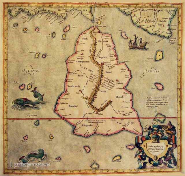
Taprobana
Taprobana (Latin: Taprobana; Ancient Greek: Ταπροβανᾶ), Trapobana, and Taprobane (Ταπροβανῆ, Ταπροβάνη) was the name by which the Indian Ocean island of Sri Lanka was known to the ancient Greeks.
Tabrobane is suggested to be derived from Sanskrit "Tamraparni". This name could be a reference to the "copper colored" shores of Sri Lanka, and may have entered Greek via the Sinhalese and/or the Pali "Tambapanni".
Reports of the island's existence were known before the time of Alexander the Great as inferred from Pliny. The treatise De Mundo, supposedly by Aristotle (died 322 BC) but according to others by Chrysippus the Stoic (280 to 208 BC), incorrectly states that the island is as large as Great Britain (in fact, it is only about one third as big). The name was first reported to Europeans by the Greek geographer Megasthenes around 290 BC. Herodotus (444 BC) does not mention the island. The first Geography in which it appears is that of Eratosthenes (276 to 196 BC) and was later adopted by Claudius Ptolemy (139 AD) in his geographical treatise to identify a relatively large island south of continental Asia. Writing during the era of Augustus, Greek geographer Strabo makes reference to the island, noting that "Taprobane sends great amounts of ivory, tortoise-shell and other merchandise to the markets of India.". Eratosthenes' map of the (for the Greeks) known world, c. 194 BC also shows the island south of India called Taprobane.
Stephanus of Byzantium writes that a metropolis of the island was called Argyra (Ancient Greek: Ἀργυρᾶ, "Silver") and that also there was a river which was called Phasis (Ancient Greek: Φᾶσις).
Aelian writes that he had heard that the island does not have cities, but 750 villages.
The identity of Ptolemy's Taprobane has been always associated with the present day Sri Lanka from maps of ancient antiquity until the medieval maps of Abu-Rehan (1030) and Edrisi (1154) and in the writing of Marco Polo (1292). Furthermore, most of the place names marked on the map can be identified with place name of the places in ancient Sri Lanka.
Also, the relative position of the island in comparison to India, being centrally situated on the Indian Ocean trade route and a major trading center for trade in elephants and golden spice as described by ancient Greek and Roman travelers, further validate the assignment of the name to Sri Lanka.
However, on the maps of the Middle Ages, the fashion of using Latinised names and delineating places with fanciful figures contributed to absurd designs and confusion regarding the actual place of Taprobane. In the fifteenth century, Niccolò de' Conti mistakenly identified Taprobana as a much smaller island. In 1507, Martin Waldseemuller still assigned Taprobana to Sri Lanka. Sebastian Munster's 1580 map identified Taprobana as Sumatra, where the German title, Sumatra Ein Grosse Insel, means, "Sumatra, a large island". Munster's map created a debate on the identity of Taprobane. Due to this debate following possibilities were considered valid for Taprobana in the Middle Ages:
Recent media
Recent media