
Community hub
Recent from talks
Contribute something to knowledge base
Content stats: 0 posts, 0 articles, 1 media, 0 notes
Members stats: 0 subscribers, 0 contributors, 0 moderators, 0 supporters
Subscribers
Supporters
Contributors
Moderators
Hub AI
Tarim River AI simulator
(@Tarim River_simulator)
Hub AI
Tarim River AI simulator
(@Tarim River_simulator)
Tarim River
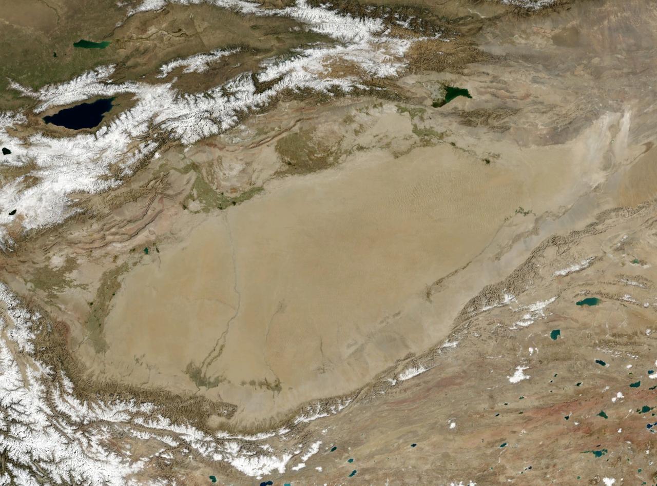
The Tarim River (Chinese: 塔里木河; pinyin: Tǎlǐmù Hé; Uyghur: تارىم دەرياسى, romanized: Tarim deryasi), known in Sanskrit as the Śītā, is an endorheic river in Xinjiang, China. It is the principal river of the Tarim Basin, a desert region of Central Asia between the Tian Shan and Kunlun Mountains. The river historically terminated at Lop Nur, but today reaches no further than Taitema Lake before drying out.
It is the longest inland river in China. The Tarim River originates from the Karakoram Mountains and flows into Lop Nur along the northern edge of the Taklimakan Desert. It has a total length of 2,327 kilometers and a drainage area of 1.02 million square kilometers. Its main tributaries include the Hotan River, the Aksu River, and the Kashgar River. The course of the Tarim River swings from north to south in history, and its migration is uncertain. The last major river change occurred in 1921, when the main stream was diverted to the east and flowed into Lop Nur through the Kongque River. In 1952, a dam was built near Yuli County, separated from the Kongque River, and the river water returned to Taitma Lake and Lop Nur through the old road of Tieganlik.
The Greek geographer Ptolemy in the 2nd century AD called the Tarim River the Oichardes River in his book "Geography". "Shui Jing Zhu" is called the South River. In the Northern dynasties, Sui and Tang dynasties, the Tarim River was called Ji-style water, Ji-shu water and Ji-shou water. The Qing dynasty's "Map of the Western Regions" called it "Erse Gol", which means "flowing water" in Mongolian. According to the "Draft of Qing History", the name of the river Tarim means "horse without reins", which describes the river's frequent diversion. In the 24th year of the reign of Emperor Jiaqing of the Qing dynasty (1819), Xu Song wrote in "The Record of the Waterways of the Western Regions": "The Hui language (Uyghur language) refers to the 'cultivable land' called Tarim, and it is said that the people living in the riverside are farming for their business."
The total length of the Yarkand-Tarim river system is 2,030 kilometres (1,260 mi), although, as the Tarim frequently changes its channel, the length tends to vary over the years.
The river is shallow, unsuitable for navigation, and because of its heavy silt load, forms a braided stream near its terminus. The area of the Tarim River Basin is about 557,000 square kilometres (215,000 sq mi). A considerable part of the Tarim's course follows no clearly defined riverbed. The water volume of the lower course of the river diminishes as a result of extensive evaporation and water-diversion schemes.
The Tarim River Basin belongs to the inland river basin, which originates from the inland rivers in the mountains around the Tarim Basin and flows into the basin, forming a centripetal water system. The river system of this basin is composed of 144 rivers originating from the Tianshan Mountains, the Pamir Plateau, the Karakoram Mountains, the Kunlun Mountains and the Altun Mountains around the Tarim Basin. The river system comprises the Weigan river system, the Aksu river system, the Kashgar river system, the Yarkand river system, the Hotan river system, the Keriya river system, and the river system.
The water source of the Tarim River completely comes from the tributaries originating from the surrounding mountainous areas, and the sediment content is very high. The average annual water volume of the Tarim River at the confluence of the three major sources is 4.299 billion cubic meters, of which the Aksu River contributes 3.358 billion cubic meters, the Yeerqiang River 23 million cubic meters, and the Hotan River 918 million cubic meters. Downstream, 212 million cubic meters are introduced from the Kongque River, and the total water volume of the main stream is 4.511 billion cubic meters. At the same time, the amount of water varies greatly due to seasonal differences. In summer, snow and glaciers melt, which increases the amount of water and decreases in winter. The Tarim River is a naturally dissipative river in history, with an average annual water consumption of 1.669 billion cubic meters in the upper reaches, 2.296 billion cubic meters in the middle reaches, and only 633 million cubic meters of water entering the downstream. The distribution of glacier runoff is uneven throughout the year. The water inflow from June to September accounts for 70%-80% of the annual runoff, and most of them are floods; the irrigation season from March to May only accounts for about 10% of the annual runoff. is likely to cause spring drought.
Precipitation in the Tarim Basin is extremely scant, and in some years it is nonexistent. In the Taklamakan Desert and in the Lop Nur basin, the average annual total of precipitation is about 12 millimetres (0.47 in). In the foothills and in several other areas of the river's basin, the precipitation amounts to from 50 to 100 millimetres (2.0 to 3.9 in) a year. In the Tian Shan it is much wetter, precipitation often exceeding 510 millimetres (20 in). Maximum temperatures in the Tarim Basin are about 40 °C (104 °F). The Tarim River freezes over every year from December through March.
Tarim River
The Tarim River (Chinese: 塔里木河; pinyin: Tǎlǐmù Hé; Uyghur: تارىم دەرياسى, romanized: Tarim deryasi), known in Sanskrit as the Śītā, is an endorheic river in Xinjiang, China. It is the principal river of the Tarim Basin, a desert region of Central Asia between the Tian Shan and Kunlun Mountains. The river historically terminated at Lop Nur, but today reaches no further than Taitema Lake before drying out.
It is the longest inland river in China. The Tarim River originates from the Karakoram Mountains and flows into Lop Nur along the northern edge of the Taklimakan Desert. It has a total length of 2,327 kilometers and a drainage area of 1.02 million square kilometers. Its main tributaries include the Hotan River, the Aksu River, and the Kashgar River. The course of the Tarim River swings from north to south in history, and its migration is uncertain. The last major river change occurred in 1921, when the main stream was diverted to the east and flowed into Lop Nur through the Kongque River. In 1952, a dam was built near Yuli County, separated from the Kongque River, and the river water returned to Taitma Lake and Lop Nur through the old road of Tieganlik.
The Greek geographer Ptolemy in the 2nd century AD called the Tarim River the Oichardes River in his book "Geography". "Shui Jing Zhu" is called the South River. In the Northern dynasties, Sui and Tang dynasties, the Tarim River was called Ji-style water, Ji-shu water and Ji-shou water. The Qing dynasty's "Map of the Western Regions" called it "Erse Gol", which means "flowing water" in Mongolian. According to the "Draft of Qing History", the name of the river Tarim means "horse without reins", which describes the river's frequent diversion. In the 24th year of the reign of Emperor Jiaqing of the Qing dynasty (1819), Xu Song wrote in "The Record of the Waterways of the Western Regions": "The Hui language (Uyghur language) refers to the 'cultivable land' called Tarim, and it is said that the people living in the riverside are farming for their business."
The total length of the Yarkand-Tarim river system is 2,030 kilometres (1,260 mi), although, as the Tarim frequently changes its channel, the length tends to vary over the years.
The river is shallow, unsuitable for navigation, and because of its heavy silt load, forms a braided stream near its terminus. The area of the Tarim River Basin is about 557,000 square kilometres (215,000 sq mi). A considerable part of the Tarim's course follows no clearly defined riverbed. The water volume of the lower course of the river diminishes as a result of extensive evaporation and water-diversion schemes.
The Tarim River Basin belongs to the inland river basin, which originates from the inland rivers in the mountains around the Tarim Basin and flows into the basin, forming a centripetal water system. The river system of this basin is composed of 144 rivers originating from the Tianshan Mountains, the Pamir Plateau, the Karakoram Mountains, the Kunlun Mountains and the Altun Mountains around the Tarim Basin. The river system comprises the Weigan river system, the Aksu river system, the Kashgar river system, the Yarkand river system, the Hotan river system, the Keriya river system, and the river system.
The water source of the Tarim River completely comes from the tributaries originating from the surrounding mountainous areas, and the sediment content is very high. The average annual water volume of the Tarim River at the confluence of the three major sources is 4.299 billion cubic meters, of which the Aksu River contributes 3.358 billion cubic meters, the Yeerqiang River 23 million cubic meters, and the Hotan River 918 million cubic meters. Downstream, 212 million cubic meters are introduced from the Kongque River, and the total water volume of the main stream is 4.511 billion cubic meters. At the same time, the amount of water varies greatly due to seasonal differences. In summer, snow and glaciers melt, which increases the amount of water and decreases in winter. The Tarim River is a naturally dissipative river in history, with an average annual water consumption of 1.669 billion cubic meters in the upper reaches, 2.296 billion cubic meters in the middle reaches, and only 633 million cubic meters of water entering the downstream. The distribution of glacier runoff is uneven throughout the year. The water inflow from June to September accounts for 70%-80% of the annual runoff, and most of them are floods; the irrigation season from March to May only accounts for about 10% of the annual runoff. is likely to cause spring drought.
Precipitation in the Tarim Basin is extremely scant, and in some years it is nonexistent. In the Taklamakan Desert and in the Lop Nur basin, the average annual total of precipitation is about 12 millimetres (0.47 in). In the foothills and in several other areas of the river's basin, the precipitation amounts to from 50 to 100 millimetres (2.0 to 3.9 in) a year. In the Tian Shan it is much wetter, precipitation often exceeding 510 millimetres (20 in). Maximum temperatures in the Tarim Basin are about 40 °C (104 °F). The Tarim River freezes over every year from December through March.
Recent media
Recent media