Community hub
Recent from talks
Knowledge base stats:
Talk channels stats:
Members stats:
Taupō Volcano
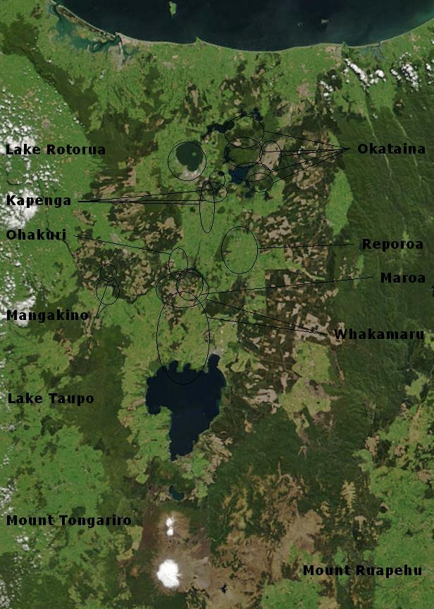
Lake Taupō, in the centre of New Zealand's North Island, fills the caldera of the Taupō Volcano, a large rhyolitic supervolcano. This huge volcano has produced two of the world's most powerful eruptions in geologically recent times.
The volcano is in the Taupō Volcanic Zone within the Taupō Rift, a region of rift volcanic activity that extends from Ruapehu in the south, through the Taupō and Rotorua districts, to Whakaari / White Island, in the Bay of Plenty.
Taupō began erupting about 300,000 years ago. The main eruptions that still affect the surrounding landscape are the dacitic Mount Tauhara eruption 65,000 years ago, the Oruanui eruption about 25,500 years ago, which is responsible for the shape of the modern caldera, and the Hatepe eruption, dated 232 ± 10 CE. There have been many more eruptions, with major ones every thousand years or so (see timeline of last 10,000 years of eruptions). The Oruanui eruption in particular destroyed or obscured much evidence of previous eruptive activity.
Taupō Volcano has not erupted for approximately 1,800 years; however, with research beginning in 1979 and published in 2022, the data collated over the 42-year period shows that Taupō Volcano is active with periods of volcanic unrest and has been for some time. Some volcanoes within the Taupō Volcanic Zone have erupted more recently. Mount Tarawera had a moderately violent VEI-5 eruption in 1886, and Whakaari/White Island is frequently active, erupting most recently in December 2019. Geologic studies published in 1888 following the eruption of Mount Tarawera first raised the possibility that there was a volcano under Lake Taupō, rather than the more obvious volcanoes near Mount Tongariro, to explain the likely source of the extensive surface pumice deposits of the central North Island.
The Taupō Volcano erupts rhyolite, a viscous magma, with a high silica content, a feature associated with the middle portion of the Taupō Volcanic Zone within the Taupō Rift. This is an intra-arc rift in the eastern part of the continental Australian Plate, resulting from an oblique convergence with the Pacific Plate in the Hikurangi subduction zone. In this region the Moho discontinuity starts about 25–30 km (16–19 mi) beneath the surface beyond the modern Taupō Rift boundaries to the west and east, but there is an area of strong contrast in seismic velocity at 16 kn (30 km/h; 18 mph) depth that is postulated to be due to intruded crust from where the feed magma is evolving. Studies show large areas of partial melt below 10 km (6.2 mi) with a brittle-ductile rock transition at approximately 6–8 km (3.7–5.0 mi) beneath the surface. For unknown as yet reasons, possibly associated with the present high rate of rift spreading and the recent subduction of the Hikurangi Plateau this area is very productive in its surface volcanism.
If the magma does not contain much gas, rhyolite tends to just form a lava dome, and such eruptions are more common. However, when mixed with gas or steam, rhyolitic eruptions can be extremely violent. The magma froths to form pumice and ash, which is thrown out with great force. Such eruptions tend to be earlier in any given eruption cycle.
If the volcano creates a stable plume, high in the atmosphere, the pumice and ash are blown sideways, and eventually fall to the ground, draping the landscape like snow.
If the material thrown out cools more rapidly and becomes denser than the air, it cannot rise as high, and suddenly collapses back to the ground, forming a pyroclastic flow, hitting the surface like water from a waterfall, and spreading sideways across the land at enormous speed. When the pumice and ash settle, they are sufficiently hot to stick together as a rock called ignimbrite. Pyroclastic flows can travel hundreds of kilometres an hour.
Hub AI
Taupō Volcano AI simulator
(@Taupō Volcano_simulator)
Taupō Volcano
Lake Taupō, in the centre of New Zealand's North Island, fills the caldera of the Taupō Volcano, a large rhyolitic supervolcano. This huge volcano has produced two of the world's most powerful eruptions in geologically recent times.
The volcano is in the Taupō Volcanic Zone within the Taupō Rift, a region of rift volcanic activity that extends from Ruapehu in the south, through the Taupō and Rotorua districts, to Whakaari / White Island, in the Bay of Plenty.
Taupō began erupting about 300,000 years ago. The main eruptions that still affect the surrounding landscape are the dacitic Mount Tauhara eruption 65,000 years ago, the Oruanui eruption about 25,500 years ago, which is responsible for the shape of the modern caldera, and the Hatepe eruption, dated 232 ± 10 CE. There have been many more eruptions, with major ones every thousand years or so (see timeline of last 10,000 years of eruptions). The Oruanui eruption in particular destroyed or obscured much evidence of previous eruptive activity.
Taupō Volcano has not erupted for approximately 1,800 years; however, with research beginning in 1979 and published in 2022, the data collated over the 42-year period shows that Taupō Volcano is active with periods of volcanic unrest and has been for some time. Some volcanoes within the Taupō Volcanic Zone have erupted more recently. Mount Tarawera had a moderately violent VEI-5 eruption in 1886, and Whakaari/White Island is frequently active, erupting most recently in December 2019. Geologic studies published in 1888 following the eruption of Mount Tarawera first raised the possibility that there was a volcano under Lake Taupō, rather than the more obvious volcanoes near Mount Tongariro, to explain the likely source of the extensive surface pumice deposits of the central North Island.
The Taupō Volcano erupts rhyolite, a viscous magma, with a high silica content, a feature associated with the middle portion of the Taupō Volcanic Zone within the Taupō Rift. This is an intra-arc rift in the eastern part of the continental Australian Plate, resulting from an oblique convergence with the Pacific Plate in the Hikurangi subduction zone. In this region the Moho discontinuity starts about 25–30 km (16–19 mi) beneath the surface beyond the modern Taupō Rift boundaries to the west and east, but there is an area of strong contrast in seismic velocity at 16 kn (30 km/h; 18 mph) depth that is postulated to be due to intruded crust from where the feed magma is evolving. Studies show large areas of partial melt below 10 km (6.2 mi) with a brittle-ductile rock transition at approximately 6–8 km (3.7–5.0 mi) beneath the surface. For unknown as yet reasons, possibly associated with the present high rate of rift spreading and the recent subduction of the Hikurangi Plateau this area is very productive in its surface volcanism.
If the magma does not contain much gas, rhyolite tends to just form a lava dome, and such eruptions are more common. However, when mixed with gas or steam, rhyolitic eruptions can be extremely violent. The magma froths to form pumice and ash, which is thrown out with great force. Such eruptions tend to be earlier in any given eruption cycle.
If the volcano creates a stable plume, high in the atmosphere, the pumice and ash are blown sideways, and eventually fall to the ground, draping the landscape like snow.
If the material thrown out cools more rapidly and becomes denser than the air, it cannot rise as high, and suddenly collapses back to the ground, forming a pyroclastic flow, hitting the surface like water from a waterfall, and spreading sideways across the land at enormous speed. When the pumice and ash settle, they are sufficiently hot to stick together as a rock called ignimbrite. Pyroclastic flows can travel hundreds of kilometres an hour.