Recent from talks
Trans-Alaska Pipeline System
Knowledge base stats:
Talk channels stats:
Members stats:
Trans-Alaska Pipeline System
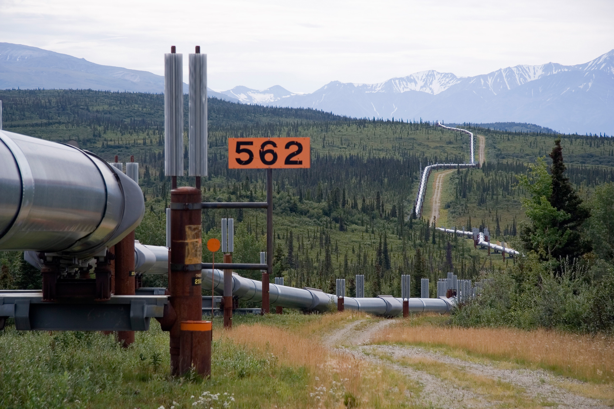
The Trans-Alaska Pipeline System (TAPS) is an oil transportation system spanning Alaska, including the trans-Alaska crude-oil pipeline, 12 pump stations, several hundred miles of feeder pipelines, and the Valdez Marine Terminal. TAPS is one of the world's largest pipeline systems. The core pipeline itself, which is commonly called the Alaska pipeline, trans-Alaska pipeline, or Alyeska pipeline, (or the pipeline as referred to by Alaskan residents), is an 800-mile (1,287 km) long, 48-inch (1.22 m) diameter pipeline that conveys oil from Prudhoe Bay, on Alaska's North Slope, south to Valdez, on the shores of Prince William Sound in southcentral Alaska. The crude oil pipeline is privately owned by the Alyeska Pipeline Service Company.
Oil was first discovered in Prudhoe Bay in 1968 and the 800 miles of 48" steel pipe was ordered from Japan in 1969 (U.S. steel manufacturers did not have the capacity at that time). However, construction was delayed for nearly 5 years due to legal and environmental issues. The eight oil companies that owned the rights to the oil hired Bechtel for the pipeline design and construction and Fluor for the 12 pump stations and the Valdez Terminal. Preconstruction work during 1973 and 1974 was critical and included the building of camps to house workers, construction of roads and bridges where none existed, and carefully laying out the pipeline right of way to avoid difficult river crossings and animal habitats. Construction of the pipeline system took place between 1975 and 1977. It was important for the United States to have a domestic source of oil to offset the high rise in foreign oil and the Alaska Pipeline fulfilled that obligation.
Building oil pipelines in the 1950s and 60s was not difficult in the contiguous United States. However, in building the Alaska Pipeline, engineers faced a wide range of difficulties, stemming mainly from the extreme cold and the difficult, isolated terrain. The construction of the pipeline was one of the first large-scale projects to deal with problems caused by permafrost, and special construction techniques had to be developed to cope with the frozen ground. The project attracted tens of thousands of workers to Alaska due to high wages, long work hours, and paid-for housing, causing a boomtown atmosphere in Valdez, Fairbanks, and Anchorage.
The first barrel of oil traveled through the pipeline in the summer of 1977, with full-scale production by the end of the year. Several notable incidents of oil leakage have occurred since, including those caused by sabotage, maintenance failures, and bullet holes. As of 2015, it had shipped over 17 billion barrels (2.7×10⁹ m3) of oil. The pipeline has been shown capable of delivering over two million barrels of oil per day but nowadays usually operates at a fraction of maximum capacity. If flow were to stop or throughput were too little, the line could freeze. The pipeline could be extended and used to transport oil produced from controversial proposed drilling projects in the nearby Arctic National Wildlife Refuge (ANWR).
Iñupiat people on the North Slope of Alaska had mined oil-saturated peat for possibly thousands of years, using it as fuel for heat and light. Whalers who stayed at Point Barrow saw the substance the Iñupiat called pitch and recognized it as petroleum. Charles Brower, a whaler who settled at Barrow and operated trading posts along the Arctic coast, directed geologist Alfred Hulse Brooks to oil seepages at Cape Simpson and Fish Creek in the far north of Alaska, east of the village of Barrow. Brooks' report confirmed the observations of Thomas Simpson, an officer of the Hudson's Bay Company who first observed the seepages in 1836. Similar seepages were found at the Canning River in 1919 by Ernest de Koven Leffingwell. Following the First World War, as the United States Navy converted its ships from coal to fuel oil, a stable supply of oil became important to the U.S. government. Accordingly, President Warren G. Harding established by executive order a series of Naval Petroleum Reserves (NPR-1 through -4) across the United States. These reserves were areas thought to be rich in oil and set aside for future drilling by the U.S. Navy. Naval Petroleum Reserve No. 4 was sited in Alaska's far north, just south of Barrow, and encompassed 23,000,000 acres (93,078 km2).
The first explorations of NPR-4 were undertaken by the U.S. Geological Survey from 1923 to 1925 and focused on mapping, identifying and characterizing coal resources in the western portion of the reserve and petroleum exploration in the eastern and northern portions of the reserve. These surveys were primarily pedestrian in nature; no drilling or remote sensing techniques were available at the time. These surveys named many of the geographic features of the areas explored, including the Philip Smith Mountains and quadrangle.
The petroleum reserve lay dormant until World War II provided an impetus to explore new oil prospects. The first renewed efforts to identify strategic oil assets were a two pronged survey using bush aircraft, local Inupiat guides, and personnel from multiple agencies to locate reported seeps. Ebbley and Joesting reported on these initial forays in 1943. Starting in 1944, the U.S. Navy funded oil exploration near Umiat Mountain, on the Colville River in the foothills of the Brooks Range. Surveyors from the U.S. Geological Survey spread across the petroleum reserve and worked to determine its extent until 1953, when the Navy suspended funding for the project. The USGS found several oil fields, most notably the Alpine and Umiat Oil Field, but none were cost-effective to develop.
Four years after the Navy suspended its survey, Richfield Oil Corporation (later Atlantic Richfield and ARCO) drilled an enormously successful oil well near the Swanson River in southern Alaska, near Kenai. The resulting Swanson River Oil Field was Alaska's first major commercially producing oil field, and it spurred the exploration and development of many others. By 1965, five oil and 11 natural gas fields had been developed. This success and the previous Navy exploration of its petroleum reserve led petroleum engineers to the conclusion that the area of Alaska north of the Brooks Range surely held large amounts of oil and gas. The problems came from the area's remoteness and harsh climate. It was estimated that between 200,000,000 barrels (32,000,000 m3) and 500,000,000 barrels (79,000,000 m3) of oil would have to be recovered to make a North Slope oil field commercially viable.
Hub AI
Trans-Alaska Pipeline System AI simulator
(@Trans-Alaska Pipeline System_simulator)
Trans-Alaska Pipeline System
The Trans-Alaska Pipeline System (TAPS) is an oil transportation system spanning Alaska, including the trans-Alaska crude-oil pipeline, 12 pump stations, several hundred miles of feeder pipelines, and the Valdez Marine Terminal. TAPS is one of the world's largest pipeline systems. The core pipeline itself, which is commonly called the Alaska pipeline, trans-Alaska pipeline, or Alyeska pipeline, (or the pipeline as referred to by Alaskan residents), is an 800-mile (1,287 km) long, 48-inch (1.22 m) diameter pipeline that conveys oil from Prudhoe Bay, on Alaska's North Slope, south to Valdez, on the shores of Prince William Sound in southcentral Alaska. The crude oil pipeline is privately owned by the Alyeska Pipeline Service Company.
Oil was first discovered in Prudhoe Bay in 1968 and the 800 miles of 48" steel pipe was ordered from Japan in 1969 (U.S. steel manufacturers did not have the capacity at that time). However, construction was delayed for nearly 5 years due to legal and environmental issues. The eight oil companies that owned the rights to the oil hired Bechtel for the pipeline design and construction and Fluor for the 12 pump stations and the Valdez Terminal. Preconstruction work during 1973 and 1974 was critical and included the building of camps to house workers, construction of roads and bridges where none existed, and carefully laying out the pipeline right of way to avoid difficult river crossings and animal habitats. Construction of the pipeline system took place between 1975 and 1977. It was important for the United States to have a domestic source of oil to offset the high rise in foreign oil and the Alaska Pipeline fulfilled that obligation.
Building oil pipelines in the 1950s and 60s was not difficult in the contiguous United States. However, in building the Alaska Pipeline, engineers faced a wide range of difficulties, stemming mainly from the extreme cold and the difficult, isolated terrain. The construction of the pipeline was one of the first large-scale projects to deal with problems caused by permafrost, and special construction techniques had to be developed to cope with the frozen ground. The project attracted tens of thousands of workers to Alaska due to high wages, long work hours, and paid-for housing, causing a boomtown atmosphere in Valdez, Fairbanks, and Anchorage.
The first barrel of oil traveled through the pipeline in the summer of 1977, with full-scale production by the end of the year. Several notable incidents of oil leakage have occurred since, including those caused by sabotage, maintenance failures, and bullet holes. As of 2015, it had shipped over 17 billion barrels (2.7×10⁹ m3) of oil. The pipeline has been shown capable of delivering over two million barrels of oil per day but nowadays usually operates at a fraction of maximum capacity. If flow were to stop or throughput were too little, the line could freeze. The pipeline could be extended and used to transport oil produced from controversial proposed drilling projects in the nearby Arctic National Wildlife Refuge (ANWR).
Iñupiat people on the North Slope of Alaska had mined oil-saturated peat for possibly thousands of years, using it as fuel for heat and light. Whalers who stayed at Point Barrow saw the substance the Iñupiat called pitch and recognized it as petroleum. Charles Brower, a whaler who settled at Barrow and operated trading posts along the Arctic coast, directed geologist Alfred Hulse Brooks to oil seepages at Cape Simpson and Fish Creek in the far north of Alaska, east of the village of Barrow. Brooks' report confirmed the observations of Thomas Simpson, an officer of the Hudson's Bay Company who first observed the seepages in 1836. Similar seepages were found at the Canning River in 1919 by Ernest de Koven Leffingwell. Following the First World War, as the United States Navy converted its ships from coal to fuel oil, a stable supply of oil became important to the U.S. government. Accordingly, President Warren G. Harding established by executive order a series of Naval Petroleum Reserves (NPR-1 through -4) across the United States. These reserves were areas thought to be rich in oil and set aside for future drilling by the U.S. Navy. Naval Petroleum Reserve No. 4 was sited in Alaska's far north, just south of Barrow, and encompassed 23,000,000 acres (93,078 km2).
The first explorations of NPR-4 were undertaken by the U.S. Geological Survey from 1923 to 1925 and focused on mapping, identifying and characterizing coal resources in the western portion of the reserve and petroleum exploration in the eastern and northern portions of the reserve. These surveys were primarily pedestrian in nature; no drilling or remote sensing techniques were available at the time. These surveys named many of the geographic features of the areas explored, including the Philip Smith Mountains and quadrangle.
The petroleum reserve lay dormant until World War II provided an impetus to explore new oil prospects. The first renewed efforts to identify strategic oil assets were a two pronged survey using bush aircraft, local Inupiat guides, and personnel from multiple agencies to locate reported seeps. Ebbley and Joesting reported on these initial forays in 1943. Starting in 1944, the U.S. Navy funded oil exploration near Umiat Mountain, on the Colville River in the foothills of the Brooks Range. Surveyors from the U.S. Geological Survey spread across the petroleum reserve and worked to determine its extent until 1953, when the Navy suspended funding for the project. The USGS found several oil fields, most notably the Alpine and Umiat Oil Field, but none were cost-effective to develop.
Four years after the Navy suspended its survey, Richfield Oil Corporation (later Atlantic Richfield and ARCO) drilled an enormously successful oil well near the Swanson River in southern Alaska, near Kenai. The resulting Swanson River Oil Field was Alaska's first major commercially producing oil field, and it spurred the exploration and development of many others. By 1965, five oil and 11 natural gas fields had been developed. This success and the previous Navy exploration of its petroleum reserve led petroleum engineers to the conclusion that the area of Alaska north of the Brooks Range surely held large amounts of oil and gas. The problems came from the area's remoteness and harsh climate. It was estimated that between 200,000,000 barrels (32,000,000 m3) and 500,000,000 barrels (79,000,000 m3) of oil would have to be recovered to make a North Slope oil field commercially viable.
Recent media