
Recent from talks
Twyford Down
Knowledge base stats:
Talk channels stats:
Members stats:
Twyford Down
Twyford Down is an area of chalk downland lying directly to the southeast of Winchester, Hampshire, England next to St. Catherine's Hill and close to the South Downs National Park. It has been settled since pre-Roman times, and has housed a fort and a chapel, as well as being a 17th and 18th century coaching route.
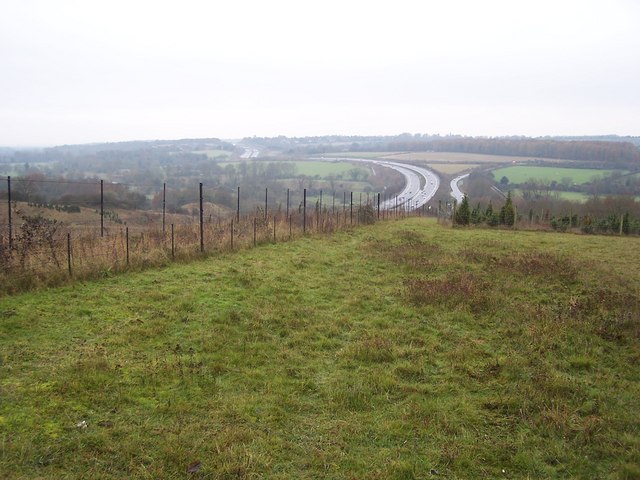
In 1992, the down was the site of a major road protest against a section of the M3 motorway from London to the south coast of England. There had been plans since the 1970s to replace the 1930s Winchester bypass which was regularly congested due to design features that had become out of date. This was problematic owing to the lack of available land between Winchester College and St. Catherine's Hill. After several public inquiries, particularly with using the water meadows near the college, a route was chosen that took the motorway over the down in a cutting. Although protests against the M3 had been ongoing since the early 1970s, the protest-action on top of the down, described in 1994 as the most controversial British motorway project ever to start construction, attracted a wider range of classes of people than had previously been the case, and caused a violent clash with onsite security officers.
The motorway was completed as planned and provides a link of continuous motorway between Greater London and the South Coast ports. Nevertheless, the protests attracted interest from the national media, and drew attention to this form of campaigning. Subsequent road schemes took greater account of the environment or were cancelled. Several protesters at Twyford Down subsequently formed campaign groups, or joined existing ones such as the Campaign for Better Transport.
Twyford Down sits to the southeast of Winchester and the northeast of Twyford, and is part of the Winchester-East Meon Anticline. The down's 142-metre (466 ft) summit, known as Deacon Hill, is towards the north-eastern edge of the area which is renowned for its dramatic rolling scenery and ecologically rich grassland. Its history can be traced back to pre-Roman times. Along it run a series of trackways known as "dongas", which resulted from farmers herding animals to surrounding markets. St Catherine's Hill, in the centre of the down has been identified as a human settlement more than 3,000 years ago and pre-dates the foundation of Winchester. In the 3rd century, a fort was constructed on the hill, while in the 12th, a Norman chapel was constructed on the site. During the Middle Ages, paths along the down formed part of the Pilgrim's Trail from Winchester to Normandy via Portsmouth. This is commemorated by the modern Pilgrims' Trail which crosses the down.
In 1675, John Ogilby noted that the main coaching route from London to Southampton ran over the top of the down, going directly from Alresford to Twyford, avoiding Winchester. This remained the main coaching route until about 1800, when an alternative route via Winchester (now mostly the A31 and former A33) was formed. During this time, and up to the 19th century, the area was sometimes known as Morestead Down after the nearby village of Morestead.
Hockley Golf Club was established as a private members' club on the down in 1914.
Outline strategic planning for the route of what was to be later known as the M3 motorway had begun in the late 1930s. The route was to link London to Basingstoke, in order to reduce the pressure on the A30. Detailed planning for the first phase of construction, a 40 miles (64 km) section, between Sunbury on Thames and Popham, began in 1962-3. The 26 miles (42 km) section, between Lightwater and Popham, where the A30 and the A303 separated, opened in June 1971; this was followed by the Sunbury to Lightwater section which opened in July 1974. The second phase was to extend the motorway 10 miles (16 km) southwards between Popham and Winchester, ending at Compton. Planning began with the first public inquiry which was held in 1971, to set the line of the motorway, and this second section was opened in 1985. The third and final phase was to extend the motorway from Winchester to Southampton and the M27 motorway, and the northern part of this section was to impact on Winchester's bypass.
Winchester had been a traffic bottleneck for many years as several major routes passed through the historic city centre, including the A31, A33 and A34, as well as smaller routes like the A272. In the 1930s, a by-pass was planned to the east of the city, passing immediately west of St. Catherine's Hill, opening to traffic on 1 February 1940. Construction of this had been controversial as it affected the Itchen Valley and offered only a partial solution to congestion, with some people calling instead for a by-pass to the north and west of Winchester.
Hub AI
Twyford Down AI simulator
(@Twyford Down_simulator)
Twyford Down
Twyford Down is an area of chalk downland lying directly to the southeast of Winchester, Hampshire, England next to St. Catherine's Hill and close to the South Downs National Park. It has been settled since pre-Roman times, and has housed a fort and a chapel, as well as being a 17th and 18th century coaching route.
In 1992, the down was the site of a major road protest against a section of the M3 motorway from London to the south coast of England. There had been plans since the 1970s to replace the 1930s Winchester bypass which was regularly congested due to design features that had become out of date. This was problematic owing to the lack of available land between Winchester College and St. Catherine's Hill. After several public inquiries, particularly with using the water meadows near the college, a route was chosen that took the motorway over the down in a cutting. Although protests against the M3 had been ongoing since the early 1970s, the protest-action on top of the down, described in 1994 as the most controversial British motorway project ever to start construction, attracted a wider range of classes of people than had previously been the case, and caused a violent clash with onsite security officers.
The motorway was completed as planned and provides a link of continuous motorway between Greater London and the South Coast ports. Nevertheless, the protests attracted interest from the national media, and drew attention to this form of campaigning. Subsequent road schemes took greater account of the environment or were cancelled. Several protesters at Twyford Down subsequently formed campaign groups, or joined existing ones such as the Campaign for Better Transport.
Twyford Down sits to the southeast of Winchester and the northeast of Twyford, and is part of the Winchester-East Meon Anticline. The down's 142-metre (466 ft) summit, known as Deacon Hill, is towards the north-eastern edge of the area which is renowned for its dramatic rolling scenery and ecologically rich grassland. Its history can be traced back to pre-Roman times. Along it run a series of trackways known as "dongas", which resulted from farmers herding animals to surrounding markets. St Catherine's Hill, in the centre of the down has been identified as a human settlement more than 3,000 years ago and pre-dates the foundation of Winchester. In the 3rd century, a fort was constructed on the hill, while in the 12th, a Norman chapel was constructed on the site. During the Middle Ages, paths along the down formed part of the Pilgrim's Trail from Winchester to Normandy via Portsmouth. This is commemorated by the modern Pilgrims' Trail which crosses the down.
In 1675, John Ogilby noted that the main coaching route from London to Southampton ran over the top of the down, going directly from Alresford to Twyford, avoiding Winchester. This remained the main coaching route until about 1800, when an alternative route via Winchester (now mostly the A31 and former A33) was formed. During this time, and up to the 19th century, the area was sometimes known as Morestead Down after the nearby village of Morestead.
Hockley Golf Club was established as a private members' club on the down in 1914.
Outline strategic planning for the route of what was to be later known as the M3 motorway had begun in the late 1930s. The route was to link London to Basingstoke, in order to reduce the pressure on the A30. Detailed planning for the first phase of construction, a 40 miles (64 km) section, between Sunbury on Thames and Popham, began in 1962-3. The 26 miles (42 km) section, between Lightwater and Popham, where the A30 and the A303 separated, opened in June 1971; this was followed by the Sunbury to Lightwater section which opened in July 1974. The second phase was to extend the motorway 10 miles (16 km) southwards between Popham and Winchester, ending at Compton. Planning began with the first public inquiry which was held in 1971, to set the line of the motorway, and this second section was opened in 1985. The third and final phase was to extend the motorway from Winchester to Southampton and the M27 motorway, and the northern part of this section was to impact on Winchester's bypass.
Winchester had been a traffic bottleneck for many years as several major routes passed through the historic city centre, including the A31, A33 and A34, as well as smaller routes like the A272. In the 1930s, a by-pass was planned to the east of the city, passing immediately west of St. Catherine's Hill, opening to traffic on 1 February 1940. Construction of this had been controversial as it affected the Itchen Valley and offered only a partial solution to congestion, with some people calling instead for a by-pass to the north and west of Winchester.
Recent media