Recent from talks
Ural (river)
Knowledge base stats:
Talk channels stats:
Members stats:
Ural (river)
The Ural, also known as the Yaik /ˈjaɪk/, is a river flowing through Russia and Kazakhstan in the continental border between Europe and Asia. It originates in the southern Ural Mountains and discharges into the Caspian Sea. At 2,428 kilometres (1,509 mi), it is the third-longest river in Europe after the Volga and the Danube, and the 18th-longest river in Asia. The Ural is conventionally considered part of the boundary between the continents of Europe and Asia.
The Ural rises near Mount Kruglaya in the Ural Mountains, flows south parallel and west of the north-flowing Tobol, through Magnitogorsk, and around the southern end of the Urals, through Orsk where it turns west for about 300 kilometres (190 mi), to Orenburg, where the river Sakmara joins. From Orenburg it continues west, passing into Kazakhstan, then turning south again at Oral, and meandering through a broad flat plain until it reaches the Caspian a few kilometers below Atyrau, where it forms a fine 'digitate' (tree-like) delta.
The river was called Δάϊκος (Daïkos) by Ptolemy in the 2nd century AD. Yulian Kulakovsky reads this as Turkic "Jajyk" or "Яик" and on this basis identifies the Huns as Turkic speakers. However, Gerard Clauson disputes that the name could be of Turkic origin as early as the 2nd century, and instead attributes it to Sarmatian origin. Also, the version of origin from the ancient Finno-Ugric and subsequent adaptation by other language groups has not been sufficiently studied (the river originates in the alleged ancestral home of the Finno-Ugric languages). In modern Finno-Ugric, the closest surviving forms are found: "joki" (Finnish), "jogi" (Karelian), "jā" (Mansi), "ju" (Komi) – river, "jəŋk" (Khanty) – water. Also, hypothetically Finno-Ugric titles may have tributaries of the Yaik River, for example Ilek (Erzya "Ilyk" – strength) and Utva (Komi "Ytva" – spring water). In the 10th-Century work De Administrando Imperio, Byzantine Emperor Constantine VII Porphyrogenitus referred to the Ural River as the "Geich." The name Яйыҡ (Yayıq) is currently used in the Bashkir language and Жайық (Zhayıq) in Kazakhstan. In later European texts it is sometimes mentioned as Rhymnus fluvius and in the Russian chronicle of 1140 as Yaik. The river was renamed Ural in the Russian language in 1775, by Catherine II of Russia.
In the 10th to 16th centuries, the city of Saray-Jük (or Saraichik, meaning "small Sarai") on the Ural River (now in Atyrau Province of Kazakhstan) was an important trade center on the Silk Road. In the 13th century, it became a stronghold of the Golden Horde. It was destroyed in 1395 by the army of Timur but then rebuilt to become the capital of Nogai Horde in the 15th and 16th centuries. It was finally reduced to a village in 1580 by the Ural Cossacks.
After the Russian conquest of the Ural basin in the late 16th century, the shores of the Ural became home to the Yaik Cossacks. One of their main activities was fishing for the sturgeon and related fishes (including the true sturgeon, starry sturgeon, and beluga) in the Ural River and the Caspian. A great variety of fishing techniques existed; the most famous of them was bagrenye (Russian: багренье, from bagor Russian: багор, meaning pike pole): spearing hibernating sturgeons in their underwater lairs in mid-winter. The bagrenye was allowed only on one day of the year. On the appointed day, a large number of Cossacks with pike poles were gathering on the shore; after a signal was given, they rushed on the ice, broke it with their poles, and speared and pulled the fish. Another fishing technique was constructing a weir, known as the uchug (учуг) across the river, to catch fish going upstream to spawn. Until 1918, an uchug was set up in the summer and autumn near Uralsk, so that the fish would not go upstream beyond the Cossacks' land. While the uchug weirs were also known in the Volga Delta, the bagrenye was thought to be a uniquely Ural technique.
The Ural Cossacks (known originally as the Yaik Cossacks) resented the attempts by the central government to impose rules and regulations on them, and on occasions rose in rebellions. The largest rebellion, the Pugachev's Rebellion of 1773–75, involved not only the Ural, but much of south-eastern Russia, and resulted in a loss of the government control there. After its suppression, Empress Catherine issued a decree of 15 January 1775 to rename most of the places involved in the revolt, in order to erase the memory of it. Thus the Yaik River and the city of Yaitsk were renamed to the Ural River and Uralsk, respectively, and the Yaik Cossacks became the Ural Cossacks.
On 6 April 2024, during the Snowmelt, a levee sheltering the city of Orsk broke. A flood in Orenburg set over 10,000 houses under water, and parts of Kazakhstan were also concerned.
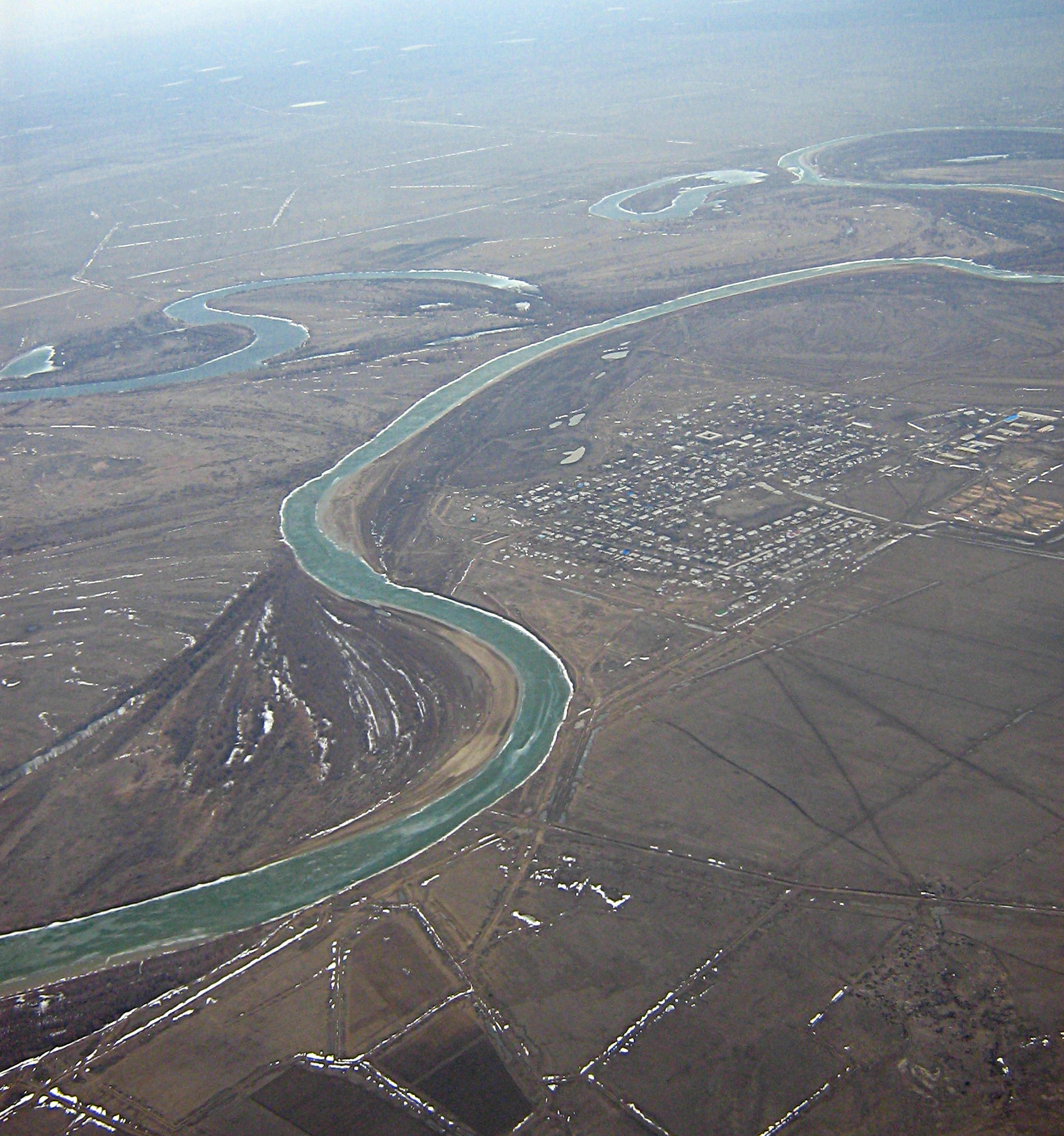
The river begins on the slopes of the Kruglaya Mountain of the Uraltau mountain ridge in South Ural, on the territory of the Uchalinsky District of Bashkortostan. There it has an average width of 60 to 80 metres (200 to 260 ft) and flows as a typical mountain river. It then falls into the Yaik Swamp and after exiting it widens up to 5 kilometres (3 mi). Below Verkhneuralsk, its flow is characteristic of a flatland river; there it enters Chelyabinsk and Orenburg Oblasts. From Magnitogorsk to Orsk its banks are steep and rocky and the bottom has many rifts. After Orsk, the river abruptly turns west and flows through a 45-kilometre (28 mi) long canyon in the Guberlinsk Mountains. After Uralsk, it flows from north to south, through the territory of West Kazakhstan Region and Atyrau Region of Kazakhstan. There, the river widens and has many lakes and ducts. Near the mouth, it splits into the Yaik and Zolotoy distributaries and forms vast wetlands. The Yaik distributary is shallow, with almost no trees on the shores, and is rich in fish; whereas Zolotoy is deeper and is navigable. Ural River has a spectacular tree-like (or "digitate") shape of the delta (see image). This type of delta forms naturally in the slow rivers which deliver a great deal of sediments and flow into a quiet sea. In the delta, 13.5 kilometres (8.4 mi) from the mouth of the Zolotoy distributary lies Shalyga Island, which is 2.5 kilometres (1.6 mi) long, with heights of 1 to 2 metres (3 to 7 ft) and maximum widths of 0.3 kilometres (980 ft).
Hub AI
Ural (river) AI simulator
(@Ural (river)_simulator)
Ural (river)
The Ural, also known as the Yaik /ˈjaɪk/, is a river flowing through Russia and Kazakhstan in the continental border between Europe and Asia. It originates in the southern Ural Mountains and discharges into the Caspian Sea. At 2,428 kilometres (1,509 mi), it is the third-longest river in Europe after the Volga and the Danube, and the 18th-longest river in Asia. The Ural is conventionally considered part of the boundary between the continents of Europe and Asia.
The Ural rises near Mount Kruglaya in the Ural Mountains, flows south parallel and west of the north-flowing Tobol, through Magnitogorsk, and around the southern end of the Urals, through Orsk where it turns west for about 300 kilometres (190 mi), to Orenburg, where the river Sakmara joins. From Orenburg it continues west, passing into Kazakhstan, then turning south again at Oral, and meandering through a broad flat plain until it reaches the Caspian a few kilometers below Atyrau, where it forms a fine 'digitate' (tree-like) delta.
The river was called Δάϊκος (Daïkos) by Ptolemy in the 2nd century AD. Yulian Kulakovsky reads this as Turkic "Jajyk" or "Яик" and on this basis identifies the Huns as Turkic speakers. However, Gerard Clauson disputes that the name could be of Turkic origin as early as the 2nd century, and instead attributes it to Sarmatian origin. Also, the version of origin from the ancient Finno-Ugric and subsequent adaptation by other language groups has not been sufficiently studied (the river originates in the alleged ancestral home of the Finno-Ugric languages). In modern Finno-Ugric, the closest surviving forms are found: "joki" (Finnish), "jogi" (Karelian), "jā" (Mansi), "ju" (Komi) – river, "jəŋk" (Khanty) – water. Also, hypothetically Finno-Ugric titles may have tributaries of the Yaik River, for example Ilek (Erzya "Ilyk" – strength) and Utva (Komi "Ytva" – spring water). In the 10th-Century work De Administrando Imperio, Byzantine Emperor Constantine VII Porphyrogenitus referred to the Ural River as the "Geich." The name Яйыҡ (Yayıq) is currently used in the Bashkir language and Жайық (Zhayıq) in Kazakhstan. In later European texts it is sometimes mentioned as Rhymnus fluvius and in the Russian chronicle of 1140 as Yaik. The river was renamed Ural in the Russian language in 1775, by Catherine II of Russia.
In the 10th to 16th centuries, the city of Saray-Jük (or Saraichik, meaning "small Sarai") on the Ural River (now in Atyrau Province of Kazakhstan) was an important trade center on the Silk Road. In the 13th century, it became a stronghold of the Golden Horde. It was destroyed in 1395 by the army of Timur but then rebuilt to become the capital of Nogai Horde in the 15th and 16th centuries. It was finally reduced to a village in 1580 by the Ural Cossacks.
After the Russian conquest of the Ural basin in the late 16th century, the shores of the Ural became home to the Yaik Cossacks. One of their main activities was fishing for the sturgeon and related fishes (including the true sturgeon, starry sturgeon, and beluga) in the Ural River and the Caspian. A great variety of fishing techniques existed; the most famous of them was bagrenye (Russian: багренье, from bagor Russian: багор, meaning pike pole): spearing hibernating sturgeons in their underwater lairs in mid-winter. The bagrenye was allowed only on one day of the year. On the appointed day, a large number of Cossacks with pike poles were gathering on the shore; after a signal was given, they rushed on the ice, broke it with their poles, and speared and pulled the fish. Another fishing technique was constructing a weir, known as the uchug (учуг) across the river, to catch fish going upstream to spawn. Until 1918, an uchug was set up in the summer and autumn near Uralsk, so that the fish would not go upstream beyond the Cossacks' land. While the uchug weirs were also known in the Volga Delta, the bagrenye was thought to be a uniquely Ural technique.
The Ural Cossacks (known originally as the Yaik Cossacks) resented the attempts by the central government to impose rules and regulations on them, and on occasions rose in rebellions. The largest rebellion, the Pugachev's Rebellion of 1773–75, involved not only the Ural, but much of south-eastern Russia, and resulted in a loss of the government control there. After its suppression, Empress Catherine issued a decree of 15 January 1775 to rename most of the places involved in the revolt, in order to erase the memory of it. Thus the Yaik River and the city of Yaitsk were renamed to the Ural River and Uralsk, respectively, and the Yaik Cossacks became the Ural Cossacks.
On 6 April 2024, during the Snowmelt, a levee sheltering the city of Orsk broke. A flood in Orenburg set over 10,000 houses under water, and parts of Kazakhstan were also concerned.
The river begins on the slopes of the Kruglaya Mountain of the Uraltau mountain ridge in South Ural, on the territory of the Uchalinsky District of Bashkortostan. There it has an average width of 60 to 80 metres (200 to 260 ft) and flows as a typical mountain river. It then falls into the Yaik Swamp and after exiting it widens up to 5 kilometres (3 mi). Below Verkhneuralsk, its flow is characteristic of a flatland river; there it enters Chelyabinsk and Orenburg Oblasts. From Magnitogorsk to Orsk its banks are steep and rocky and the bottom has many rifts. After Orsk, the river abruptly turns west and flows through a 45-kilometre (28 mi) long canyon in the Guberlinsk Mountains. After Uralsk, it flows from north to south, through the territory of West Kazakhstan Region and Atyrau Region of Kazakhstan. There, the river widens and has many lakes and ducts. Near the mouth, it splits into the Yaik and Zolotoy distributaries and forms vast wetlands. The Yaik distributary is shallow, with almost no trees on the shores, and is rich in fish; whereas Zolotoy is deeper and is navigable. Ural River has a spectacular tree-like (or "digitate") shape of the delta (see image). This type of delta forms naturally in the slow rivers which deliver a great deal of sediments and flow into a quiet sea. In the delta, 13.5 kilometres (8.4 mi) from the mouth of the Zolotoy distributary lies Shalyga Island, which is 2.5 kilometres (1.6 mi) long, with heights of 1 to 2 metres (3 to 7 ft) and maximum widths of 0.3 kilometres (980 ft).
Recent media