Hubbry Logo
Warren FieldWarren FieldMain
Open search
Warren Field
Community hub
Warren Field
logo
8 pages, 0 posts
0 subscribers
Be the first to start a discussion here.
Warren Field
Warren Field
from Wikipedia

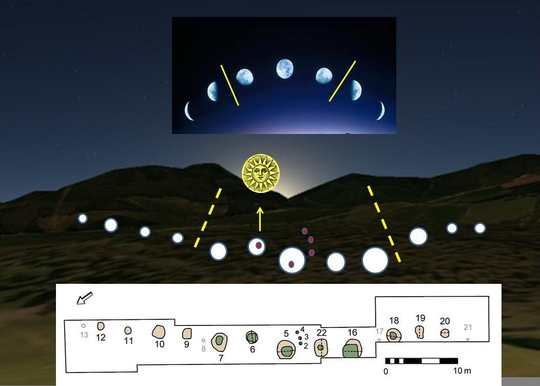
Warren Field is a Mesolithic archaeological site in Aberdeenshire, Scotland, built about 8,000 BCE and interpreted as a calendar monument.[1] It includes 12 pits believed to correlate with phases of the Moon and used as a lunisolar calendar.[2] It is considered to be the oldest lunisolar calendar yet found.[3][1][4] It is near Crathes Castle, in the Aberdeenshire region of Scotland, in the United Kingdom. It was originally discovered from the air as anomalous terrain by the Royal Commission on the Ancient and Historical Monuments of Scotland.[1] It was first excavated in 2004.

Key Information

The pits align on the southeast horizon and a prominent topographic point associated with sunrise on the midwinter solstice (thus providing an annual astronomical correction concerning the passage of time as indicated by the Moon, the asynchronous solar year, and the associated seasons).[2] The Aberdeenshire time reckoner predates the Mesopotamian calendars by nearly 5,000 years.[2] It was also interpreted as a seasonal calendar because the local prehistoric communities, which relied on hunting migrating animals, needed to carefully note the seasons to be prepared for a particular food source.[3] The Warren Field site is particularly significant for its very early date and that it was created by hunter-gatherer peoples.[1]

Warren Field lunar calendar, illustration.[2]

See also

[edit]

References

[edit]
Revisions and contributorsEdit on WikipediaRead on Wikipedia
from Grokipedia
Warren Field is an archaeological site in , , near , featuring a pit alignment constructed around 8000 BCE and interpreted as the world's oldest known luni-solar 'time-reckoner'. The monument consists of twelve large pits arranged in a shallow arc spanning approximately 50 meters, each originally holding timber posts that likely marked the phases of the over a 12-month lunar year. This alignment, oriented toward the southeast horizon, allowed prehistoric hunter-gatherers to track lunar neaps and springs while incorporating an annual solar correction aligned with the midwinter sunrise, predating similar calendrical systems in by nearly 5,000 years. The site was first identified in the 1970s through revealing cropmarks, but systematic excavation occurred between 2004 and 2006 by the in collaboration with the and other institutions. of organic remains, including hazelnut shells from the pit fills, confirmed the Mesolithic origins of the alignment, with the pits showing evidence of repeated use and maintenance over generations. Adjacent to the pits lies a larger Neolithic timber hall, a rectangular post-built structure dated to around 4000 BCE, suggesting the site's continued cultural importance into the early farming period. The discovery challenges previous assumptions about timekeeping in , demonstrating sophisticated astronomical knowledge among mobile societies and highlighting Warren Field's role in early seasonal and practices. The site's interpretation as a was detailed in a 2013 study published in Internet Archaeology, emphasizing its unique integration of lunar and solar observations within the local .

Location and Discovery

Geographical Context

Warren Field is situated in a field approximately 350 meters east-southeast of , within the region of , specifically in the fertile valley of the River Dee. The site occupies gently sloping ground at around 55 meters above , forming part of a flat terrace surface composed of post-glacial sands and gravels, which provided a stable setting for early human activity. This positioning orients the terrain toward the southeast horizon, where the site's features subtly align with the midwinter solstice sunrise. The surrounding landscape consists of productive agricultural land, where cropmarks from ancient features remain visible due to differential crop growth in underlying archaeological deposits. As part of the broader Dee Valley, the area is renowned for its concentration of Mesolithic and Neolithic archaeological remains, reflecting sustained prehistoric occupation along this riverine corridor. The valley's post-glacial environment, characterized by gravel and sand terraces flanking the river, supported diverse resources for early inhabitants, including abundant salmon runs in the Dee and extensive forested zones providing game and plant materials during the Mesolithic period.

Aerial Detection

The Warren Field site was first detected in 1976 through conducted by the Royal Commission on the Ancient and Historical Monuments of Scotland (RCAHMS), which revealed unusual crop marks indicative of subsurface archaeological features. These crop marks manifested as an irregular line of pits extending for at least 80 meters in a northeast-to-southwest orientation, accompanied by scattered pits and a large rectangular feature suggestive of a timber structure, all visible in arable fields approximately 350 meters east-southeast of . Aerial archaeology played a pivotal role in this discovery, leveraging low-altitude oblique photography from light aircraft to capture differential growth patterns in crops stressed by underlying buried remains. The particularly dry summer of 1976 enhanced visibility, as parched conditions amplified soil moisture variations caused by pits and ditches, making crop marks more pronounced in cereal fields. This technique, which had seen expanded use in Scotland during such weather, allowed RCAHMS surveyors to identify the site's potential without ground disturbance. Subsequent initial surveys, including further aerial analysis and ground assessments prompted by the 1976 photographs, confirmed the archaeological significance of the crop marks, highlighting a multi-period sequence of features warranting protection. This recognition prompted further protection efforts, including the scheduling of the associated timber hall, to preserve the pit alignment and structures for future study.

Excavation and Features

Excavation History

The primary excavations at Warren Field were carried out from 2004 to 2006 by the in collaboration with Murray Archaeological Services Ltd., following the initial detection of cropmark anomalies via . The investigative approach began with non-invasive geophysical surveys, including magnetometry to detect magnetic anomalies and resistivity surveys to identify variations in soil resistance, which helped delineate subsurface features for targeted intervention. These surveys were complemented by open-area excavations that focused on the most prominent cropmark indications, allowing for the systematic recovery of archaeological materials while minimizing disturbance to the surrounding landscape. The work encompassed key areas of the site, prioritizing zones with high potential for intact deposits. Chronologies were established through of organic remains, such as charcoal, carbonised wood, and charred plant materials, with a total of thirty-eight determinations obtained to refine the site's temporal framework. The site's position on active farmland presented significant challenges, requiring excavations to be scheduled around agricultural activities and employing strategies to protect vulnerable deposits from further damage and natural leaching. No major human remains or burials were encountered during these operations.

Mesolithic Pit Alignment

The pit alignment at Warren Field consists of 12 pits arranged in a gently curving arc, aligned from southwest to northeast across sloping ground spanning approximately 50 . Each pit measures roughly 2 in diameter and reaches depths of up to 0.5 or more, with the central section featuring the largest examples. Excavations revealed posthole evidence within the pits indicative of wooden stakes or posts, suggesting they originally held timber elements that were later removed or decayed. Some pits show signs of deliberate backfilling, incorporating layers of and carbonized shells, which point to intentional deposition by the site's inhabitants. Radiocarbon dating of organic materials from the primary fills of several pits, including pits 16, 18, and 19, yields calibrated dates centering around 8000 BC in the early , firmly establishing the alignment's construction during the period by communities. Adjacent to the largest pit (pit 5), three smaller, undated postholes were identified, potentially representing additional structural components associated with the alignment. Further southeast, about 40 meters away, five undated post-pits may relate to the feature, though their connection remains tentative.

Neolithic Timber Hall

The Neolithic Timber Hall at Warren Field represents one of the earliest substantial timber buildings in northeast Scotland, constructed during the Early period. The structure is rectangular in form, measuring approximately 24 meters in length by 9 meters in width externally, with straight side walls and rounded ends. These dimensions were first apparent as cropmarks in aerial photographs and were confirmed through targeted excavations that revealed the underlying posthole layout. The hall's orientation aligns roughly east-west, underscoring its integration into the local . Excavations uncovered a dense pattern of postholes indicating a robust post-and-beam method, where vertical timbers supported horizontal beams to form the framework of the building. The posts varied in , with larger ones likely serving as principal supports along the walls and internal divisions, while smaller stakeholes suggested lightweight partitioning or fittings within the interior space. The structure's roof was probably thatched, a common technique inferred from the absence of heavy roofing post evidence and comparable regional examples, allowing for a spacious enclosed area of around 200 square meters. This design reflects advanced skills, with timbers sourced from local and based on . Radiocarbon dating, utilizing accelerator mass spectrometry on short-lived samples such as wood from post fills and associated organic residues, establishes the hall's construction in the first half of the , specifically calibrated to circa 3820–3690 BC at 95.4% probability. This chronology positions the Warren Field hall among the earliest dated timber monuments in Britain, predating many stone-based structures. The dates derive from multiple samples across the site, modeled using Bayesian statistical methods to refine the building phase and distinguish it from earlier activity at the location. Among the artifacts recovered were worked flint tools, including scrapers and blades typical of Early lithic technology, alongside sherds of plain and decorated belonging to the Carinated Bowl tradition. These finds, concentrated in posthole fills and floor levels, indicate domestic or communal use linked to emerging farming practices, such as processing evidenced by carbonized grain residues. The 's organic residues further suggest food preparation involving dairy and meat, tying the hall to early agricultural communities in . No metalwork or exotic imports were present, emphasizing the structure's role in local material culture.

Interpretation and Function

Calendar Mechanism

The pit alignment at Warren Field functions as a luni-solar timekeeping device, where the 12 pits were likely used to track the progression of lunar months by inserting a post into a new pit approximately every 29 or 30 days, thereby mimicking the cyclical phases of the over the course of a year. This method allowed Mesolithic inhabitants to maintain a record of lunar time, with each pit representing a month's passage as observed through direct celestial monitoring. To reconcile the discrepancy between the lunar and solar calendars, the alignment incorporates an intercalation mechanism every eighth pit: after approximately eight lunar months—or about 236 days—an extended interval is observed, culminating in the alignment of the calendar with the solar year of roughly 365 days through the sighting of the midwinter sunrise from pit 6. This adjustment ensures synchronization with seasonal cycles, preventing drift from solar events critical to life. The underlying mathematical principle relies on the average length of a synodic , which is approximately 29.53 days, resulting in 12 lunar months totaling about 354 days and necessitating periodic intercalations to align with the 365-day solar year and maintain seasonal relevance. Simulation models of the pit alignment's operation demonstrate its high precision in forecasting key environmental events, such as the timing of salmon runs in the River Dee, by integrating lunar tracking with solar observations to optimize resource scheduling for Mesolithic communities.

Astronomical and Seasonal Role

The alignment of the Warren Field pit sequence is oriented toward the southeast horizon, with the midwinter solstice sunrise visible specifically from the sixth pit through a topographic notch at the Slug Road pass between Cairn-Mon-Earn and Craigberg hills, as confirmed by horizon modeling adjusted for eighth-millennium BC astronomical conditions. This orientation provided a fixed solar reference point against which the lunar cycle could be calibrated, enabling users to observe the sun's position relative to the pits during the . The interpretation of the site as a luni-solar calendar, proposed in a 2013 study, has been subject to some scholarly debate regarding its deliberate timekeeping purpose. The site's luni-solar system addressed the inherent drift of lunar months relative to the solar year by incorporating intercalation mechanisms, where the solstice alignment allowed for periodic adjustments to reset the and align it with seasonal realities, thereby facilitating reliable prediction of the . Such corrections were essential, as a purely lunar reckoning would accumulate errors of about 11 days per year, disrupting synchronization with environmental cycles. In practical terms, this timekeeping likely supported seasonal activities critical to hunter-gatherers, including timing communal gatherings, exploiting the River Dee's salmon migrations in late summer and early autumn, and harvesting wild hazelnuts during the same period when they ripen abundantly in northeast . These applications underscore the calendar's role in optimizing resource procurement and social coordination based on predictable natural rhythms. Unlike sites focused on solar-only observations, Warren Field emphasizes an integrated luni-solar approach with no evidence of exclusive solar tracking, marking it as a distinctive prehistoric European that combined lunar phases with annual solar resets for enhanced seasonal utility. This system's complexity, dating to around 8000 BC, predates other known calendars by millennia and reflects sophisticated environmental adaptation.

Archaeological Significance

Mesolithic Timekeeping

The discovery of the Warren Field pit alignment, interpreted as the earliest known , was detailed in a 2013 publication by a University of Birmingham-led team under Vince Gaffney, appearing in Internet Archaeology. This luni-solar time-reckoner, dated to approximately 8000 BC, demonstrates that hunter-gatherers in northern possessed advanced abstract thinking capabilities, enabling them to conceptualize and track extended temporal cycles well before the advent of or sedentary lifestyles. By aligning pits to monitor lunar phases and incorporate solar corrections, the structure reveals a sophisticated cognitive framework for reckoning time on both monthly and annual scales, highlighting the intellectual complexity of pre-Neolithic societies. This finding challenges longstanding assumptions that early hunter-gatherers maintained only rudimentary awareness of time, limited to immediate daily or seasonal cues. Instead, the deliberate construction of a monumental alignment around 8000 BC underscores a purposeful in timekeeping , anticipating discrepancies in lunar calendars through annual astronomical adjustments and demonstrating foresight in temporal management. Such innovation reflects a level of societal organization capable of sustaining long-term observational practices, far exceeding expectations for mobile groups in the post-glacial . In the social context of northern Britain, this calendar likely served to facilitate group coordination for seasonal mobility patterns and amid Scotland's fluctuating post-glacial environment. By providing a reliable mechanism to predict lunar months and solar years, it would have enabled communities to synchronize gatherings, optimize and expeditions, and adapt to environmental rhythms, thereby enhancing survival strategies. The suggests that these hunter-gatherers not only recognized the need for precise time tracking but also possessed the communal capacity to implement it, marking a pivotal advancement in prehistoric societal .

Neolithic Context and Comparisons

The Neolithic timber hall at Warren Field, dating to approximately 3800–3600 BC, exemplifies the early transition to farming communities in northeast , where evidence of cereal cultivation—including bread , , , oats, and —alongside dairying indicated by milk fats in associated , points to the adoption of settled within a managed clearing of about 2 km in extent. This large rectangular structure, measuring roughly 24 m by 8.5 m with internal partitions and post-built , likely served communal purposes such as feasting, ceremonies, or gatherings for up to 50 individuals, as suggested by its scale and the presence of non-structural timbers indicative of ritual significance rather than everyday domestic use. Situated in Aberdeenshire's emerging ceremonial landscape near the River Dee at low elevation for optimal access to resources, the hall reflects among early farming groups transitioning from mobile lifestyles. Comparisons with other Scottish Neolithic halls highlight both shared traits and distinctive features at Warren Field; like the nearby Balbridie hall (approximately 1 km distant, 24 m by 12 m, also early and deliberately burnt post-use), it shares a rectangular plan, advanced timber-working with split oak planks, and associations with Carinated Bowl pottery, suggesting parallel developments in monumental architecture for communal or symbolic functions. Similarities extend to sites such as Claish in and in , where large roofed buildings indicate early and partial mobility tied to crop tending. However, Warren Field stands out due to its close proximity to pit alignments, integrating construction into a landscape of pre-existing features, unlike more isolated halls; in contrast to southern British longhouses (e.g., at Lismore Fields or White Horse Stone, typically smaller at 15–18 m long, often unroofed, and from the latter ), the Scottish examples emphasize larger, enclosed spaces potentially for aggregation rather than prolonged habitation. The site's dual chronology underscores continuity in human use of the location, with the hall overlying Mesolithic activity layers and succeeding pit alignments dated to around 4000–3700 BC, spanning over 4,000 years from occupations to farming settlements without evidence of abandonment. This persistence highlights gradual cultural adaptation, including shared timber technologies like plank splitting, linking pre-farming rituals to communal practices in a stable riverside setting. Within the broader Neolithic record of northeast Scotland, Warren Field contributes to understanding a landscape rich in monumental traditions, evidenced by later recumbent stone circles (c. 3000–2500 BC) that may represent evolving ceremonial complexes, alongside trade networks indicated by Arran pitchstone artifacts at the site. This integration positions the hall as a key marker of Neolithisation through immigration and local adaptation, emphasizing Aberdeenshire's role in early agricultural and social developments.

References

Add your contribution
Related Hubs
User Avatar
No comments yet.