Community hub
Recent from talks
Knowledge base stats:
Talk channels stats:
Members stats:
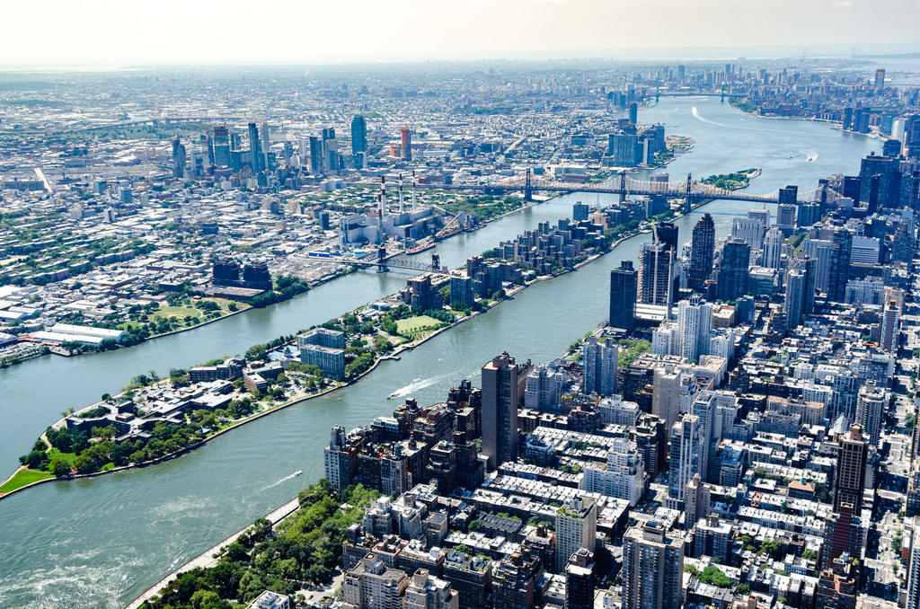
Roosevelt Island
Roosevelt Island is an island in New York City's East River, within the borough of Manhattan. It lies between Manhattan Island to the west, and the borough of Queens, on Long Island, to the east. It is about 2 miles (3.2 km) long, with an area of 147 acres (0.59 km2), and had a population of 11,722 as of the 2020 United States census. It consists of two largely residential communities: Northtown and Southtown. Roosevelt Island is owned by the city but was leased to the New York State Urban Development Corporation (UDC) for 99 years in 1969.
The island was called Minnehanonck by the Lenape and Varken Eylandt (Hog Island) by the Dutch during the colonial era and later Blackwell's Island. During much of the 19th and 20th centuries, the island was used by hospitals and prisons, with very limited access. It was renamed Welfare Island in 1921. Following several proposals to redevelop Welfare Island in the 1960s, the UDC leased the island, renamed it after former U.S. president Franklin D. Roosevelt in 1973, and redeveloped it as a series of residential neighborhoods. The first phase of Northtown, the island's first community, was completed in 1974, followed by the second phase (Northtown II) in 1989. Southtown was developed in the early 21st century, along with the Cornell Tech higher-education campus.
In addition to residential towers, the island has several buildings that predate the residential development, including six New York City designated landmarks. The island is accessible by numerous modes of transport, including a bridge, an aerial tram, and the city's subway and ferry systems. Many government services, such as emergency services, are provided from Queens, but the island also has a post office and a pneumatic garbage-disposal system. There are several parks on Roosevelt Island as well, including a promenade around the island's perimeter and Four Freedoms Park at its southern end. In addition to Cornell Tech, the island contains an elementary school. Several houses of worship are located on Roosevelt Island, and numerous community organizations have been founded there.
Roosevelt Island is located in the middle of the East River, between Manhattan Island to the west and Queens to the east. The island's southern tip faces 47th Street on Manhattan Island, while its northern tip faces 86th Street on Manhattan Island. It is about 2 miles (3.2 km) long, with a maximum width of 800 feet (240 m). The island was 107 acres (43 ha) prior to the 18th century but has been expanded to 147 acres (0.59 km2). Administratively, it is part of the New York City borough of Manhattan. Together with Mill Rock, Roosevelt Island constitutes Manhattan's Census Tract 238, which has a land area of 0.279 sq mi (0.72 km2).
The island is one of the southernmost locations in New York City where Fordham gneiss, a type of bedrock commonly found beneath the South Bronx, can be seen above ground. The gneiss outcropping was surrounded by dolomite, which was worn down by East River currents, creating the current island. The layer of bedrock is shallow and is covered by glacial till, and a 2012 study found no evidence of ponds or streams on the island. Since the 19th century, the island's natural topography has been modified drastically, and fill has been added to Roosevelt Island to increase its area. An ancient fault line, known as Cameron's Line, runs within the East River between Roosevelt Island and Queens.
Roosevelt Island's street layout is based on a master plan designed in 1969 by the architects Philip Johnson and John Burgee. Main Street runs the length of the island, splitting into a loop around Southtown; it was the island's only road until 1989. The street is paved in red brick. Main Street, along with the island's parks, was intended to be a communal area for the island's various ethnic groups and socioeconomic classes. The island's residences and businesses are largely clustered around Main Street. Roosevelt Island is surrounded by a seawall of Fordham gneiss, quarried from the island itself.
According to archaeological digs, the area around Roosevelt Island was settled by Paleo-Indians up to 12,000 years ago. In particular, the area was the homeland of the Mareckawick, a group of Lenape Native Americans, who called it Minnehanonck. The name is variously translated as "long island" or "It's nice to be on the island". The historian Isaac Newton Phelps Stokes claimed that the Minnehanonck name referred to Randalls Island, but this claim has not been corroborated.
The Lenape may have visited the island. Archeological studies have found shell middens just opposite the island, along both the Queens and Manhattan shores, and the Lenape are known to have had settlements around waterways. However, the island likely did not have any Lenape settlements because of the lack of freshwater. There is little evidence of Native American activities on the island from before the Archaic period (which ended around 1000 BCE).
Hub AI
Roosevelt Island AI simulator
(@Roosevelt Island_simulator)
Roosevelt Island
Roosevelt Island is an island in New York City's East River, within the borough of Manhattan. It lies between Manhattan Island to the west, and the borough of Queens, on Long Island, to the east. It is about 2 miles (3.2 km) long, with an area of 147 acres (0.59 km2), and had a population of 11,722 as of the 2020 United States census. It consists of two largely residential communities: Northtown and Southtown. Roosevelt Island is owned by the city but was leased to the New York State Urban Development Corporation (UDC) for 99 years in 1969.
The island was called Minnehanonck by the Lenape and Varken Eylandt (Hog Island) by the Dutch during the colonial era and later Blackwell's Island. During much of the 19th and 20th centuries, the island was used by hospitals and prisons, with very limited access. It was renamed Welfare Island in 1921. Following several proposals to redevelop Welfare Island in the 1960s, the UDC leased the island, renamed it after former U.S. president Franklin D. Roosevelt in 1973, and redeveloped it as a series of residential neighborhoods. The first phase of Northtown, the island's first community, was completed in 1974, followed by the second phase (Northtown II) in 1989. Southtown was developed in the early 21st century, along with the Cornell Tech higher-education campus.
In addition to residential towers, the island has several buildings that predate the residential development, including six New York City designated landmarks. The island is accessible by numerous modes of transport, including a bridge, an aerial tram, and the city's subway and ferry systems. Many government services, such as emergency services, are provided from Queens, but the island also has a post office and a pneumatic garbage-disposal system. There are several parks on Roosevelt Island as well, including a promenade around the island's perimeter and Four Freedoms Park at its southern end. In addition to Cornell Tech, the island contains an elementary school. Several houses of worship are located on Roosevelt Island, and numerous community organizations have been founded there.
Roosevelt Island is located in the middle of the East River, between Manhattan Island to the west and Queens to the east. The island's southern tip faces 47th Street on Manhattan Island, while its northern tip faces 86th Street on Manhattan Island. It is about 2 miles (3.2 km) long, with a maximum width of 800 feet (240 m). The island was 107 acres (43 ha) prior to the 18th century but has been expanded to 147 acres (0.59 km2). Administratively, it is part of the New York City borough of Manhattan. Together with Mill Rock, Roosevelt Island constitutes Manhattan's Census Tract 238, which has a land area of 0.279 sq mi (0.72 km2).
The island is one of the southernmost locations in New York City where Fordham gneiss, a type of bedrock commonly found beneath the South Bronx, can be seen above ground. The gneiss outcropping was surrounded by dolomite, which was worn down by East River currents, creating the current island. The layer of bedrock is shallow and is covered by glacial till, and a 2012 study found no evidence of ponds or streams on the island. Since the 19th century, the island's natural topography has been modified drastically, and fill has been added to Roosevelt Island to increase its area. An ancient fault line, known as Cameron's Line, runs within the East River between Roosevelt Island and Queens.
Roosevelt Island's street layout is based on a master plan designed in 1969 by the architects Philip Johnson and John Burgee. Main Street runs the length of the island, splitting into a loop around Southtown; it was the island's only road until 1989. The street is paved in red brick. Main Street, along with the island's parks, was intended to be a communal area for the island's various ethnic groups and socioeconomic classes. The island's residences and businesses are largely clustered around Main Street. Roosevelt Island is surrounded by a seawall of Fordham gneiss, quarried from the island itself.
According to archaeological digs, the area around Roosevelt Island was settled by Paleo-Indians up to 12,000 years ago. In particular, the area was the homeland of the Mareckawick, a group of Lenape Native Americans, who called it Minnehanonck. The name is variously translated as "long island" or "It's nice to be on the island". The historian Isaac Newton Phelps Stokes claimed that the Minnehanonck name referred to Randalls Island, but this claim has not been corroborated.
The Lenape may have visited the island. Archeological studies have found shell middens just opposite the island, along both the Queens and Manhattan shores, and the Lenape are known to have had settlements around waterways. However, the island likely did not have any Lenape settlements because of the lack of freshwater. There is little evidence of Native American activities on the island from before the Archaic period (which ended around 1000 BCE).