
Community hub
Recent from talks
Contribute something to knowledge base
Content stats: 0 posts, 0 articles, 1 media, 0 notes
Members stats: 0 subscribers, 0 contributors, 0 moderators, 0 supporters
Subscribers
Supporters
Contributors
Moderators
Hub AI
Willamette Falls AI simulator
(@Willamette Falls_simulator)
Hub AI
Willamette Falls AI simulator
(@Willamette Falls_simulator)
Willamette Falls
The Willamette Falls is a natural waterfall in the northwestern United States, located on the Willamette River between Oregon City and West Linn, Oregon. The largest waterfall in the Northwest U.S. by volume, it is the seventeenth widest in the world. Horseshoe in shape, it is 1,500 feet (455 m) wide and forty feet (12 m) high, with a flow rate of 30,850 cu ft/s (874 m3/s). Located 26 miles (42 km) upriver from the Willamette's mouth at Portland, Willamette Falls is a culturally significant site for many tribal communities in the region.
Opened in 1873 and closed since 2011, the Willamette Falls Locks allowed boat traffic on the Willamette to pass into the main Willamette Valley.
Native American oral history taught that the falls were placed there by the ancient hero T'allapus (Coyote) so that their people would have fish to eat all winter.· Willamette Falls was once the home to the Charcowah village of the Clowewalla band of Tumwaters or Willamette Band of Tumwaters, an upper Chinookan speaking people. These lands were ceded to the United States Government under the Willamette Valley Treaty of 1855 (signed on January 22, 1855; ratified on March 3, 1855). Tribal members were then removed from these ancestral lands to the Grand Ronde Reservation and the Siletz Indian Reservation.
Willamette Falls is an important location for many tribes. The abundance of salmon brought tribal communities from all over to fish, trade, and interact at the falls - creating an economic and cultural hub for the region. Each year many tribes harvest ceremonial salmon at Willamette Falls and collect lamprey during the summer, including the Confederated Tribes and Bands of the Yakama Nation, the Confederated Tribes of the Grand Ronde, the Confederated Tribes of Siletz Indians, the Confederated Tribes of the Umatilla Indian Reservation, and the Confederated Tribes of Warm Springs.
European fur traders became aware of the falls in 1810. John McLoughlin established a land claim at the falls in the name of the Hudson's Bay Company in 1829. Oregon City was established in 1842 near the east end of the falls. The town of Linn City was founded on the western shore one year later in 1843. The two towns competed economically, vying for the lucrative steamboat traffic and the trade it generated. With the falls representing the end of the line for boat traffic, river boat captains were forced to choose a side of the river on which they would dock to unload their passengers and goods; some of which would continue their upriver journey on winding portage toll roads. Competition between the towns was fierce until the Great Flood of 1862. Oregon City was inundated and badly damaged, while Linn City was obliterated.
Navigating past the falls was not possible until the completion of the Willamette Falls Locks in 1873. During construction of the locks, channels were blasted from the rocks that formerly supported the town of Linn City. Along with the locks, the city of West Linn sits on a portion of the former town site. The locks were sold by the Willamette Falls Canal and Locks Company to the United States Army Corps of Engineers in 1915. They were closed in 2011.
The Willamette Falls Electric Company (later renamed Portland General Electric) was formed in 1888 to build a hydro-electric generation facility at the falls. Four turbine-driven dynamos were built on the east end of the falls. A 14-mile (23-kilometer) long transmission line to Portland was built, becoming the first long-distance transmission of electrical energy in the United States in 1889.
In 1895 Portland General Electric built a second generation station on the west side of the falls. The newer plant, called the T.W.Sullivan Plant (previously Station B), is still in operation with a capacity of 16,000 kilowatts. The foundations of the old plant still remain.
Willamette Falls
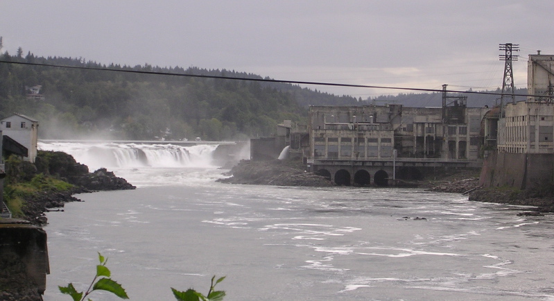
The Willamette Falls is a natural waterfall in the northwestern United States, located on the Willamette River between Oregon City and West Linn, Oregon. The largest waterfall in the Northwest U.S. by volume, it is the seventeenth widest in the world. Horseshoe in shape, it is 1,500 feet (455 m) wide and forty feet (12 m) high, with a flow rate of 30,850 cu ft/s (874 m3/s). Located 26 miles (42 km) upriver from the Willamette's mouth at Portland, Willamette Falls is a culturally significant site for many tribal communities in the region.
Opened in 1873 and closed since 2011, the Willamette Falls Locks allowed boat traffic on the Willamette to pass into the main Willamette Valley.
Native American oral history taught that the falls were placed there by the ancient hero T'allapus (Coyote) so that their people would have fish to eat all winter.· Willamette Falls was once the home to the Charcowah village of the Clowewalla band of Tumwaters or Willamette Band of Tumwaters, an upper Chinookan speaking people. These lands were ceded to the United States Government under the Willamette Valley Treaty of 1855 (signed on January 22, 1855; ratified on March 3, 1855). Tribal members were then removed from these ancestral lands to the Grand Ronde Reservation and the Siletz Indian Reservation.
Willamette Falls is an important location for many tribes. The abundance of salmon brought tribal communities from all over to fish, trade, and interact at the falls - creating an economic and cultural hub for the region. Each year many tribes harvest ceremonial salmon at Willamette Falls and collect lamprey during the summer, including the Confederated Tribes and Bands of the Yakama Nation, the Confederated Tribes of the Grand Ronde, the Confederated Tribes of Siletz Indians, the Confederated Tribes of the Umatilla Indian Reservation, and the Confederated Tribes of Warm Springs.
European fur traders became aware of the falls in 1810. John McLoughlin established a land claim at the falls in the name of the Hudson's Bay Company in 1829. Oregon City was established in 1842 near the east end of the falls. The town of Linn City was founded on the western shore one year later in 1843. The two towns competed economically, vying for the lucrative steamboat traffic and the trade it generated. With the falls representing the end of the line for boat traffic, river boat captains were forced to choose a side of the river on which they would dock to unload their passengers and goods; some of which would continue their upriver journey on winding portage toll roads. Competition between the towns was fierce until the Great Flood of 1862. Oregon City was inundated and badly damaged, while Linn City was obliterated.
Navigating past the falls was not possible until the completion of the Willamette Falls Locks in 1873. During construction of the locks, channels were blasted from the rocks that formerly supported the town of Linn City. Along with the locks, the city of West Linn sits on a portion of the former town site. The locks were sold by the Willamette Falls Canal and Locks Company to the United States Army Corps of Engineers in 1915. They were closed in 2011.
The Willamette Falls Electric Company (later renamed Portland General Electric) was formed in 1888 to build a hydro-electric generation facility at the falls. Four turbine-driven dynamos were built on the east end of the falls. A 14-mile (23-kilometer) long transmission line to Portland was built, becoming the first long-distance transmission of electrical energy in the United States in 1889.
In 1895 Portland General Electric built a second generation station on the west side of the falls. The newer plant, called the T.W.Sullivan Plant (previously Station B), is still in operation with a capacity of 16,000 kilowatts. The foundations of the old plant still remain.
Recent media
Recent media